
A Quick Cooldown… Then Spring Heat Returns

The Southern Tennessee Weather Blog is proudly presented by Heritage South Community Credit Union.
We Help When Others Won’t!
Visit https://www.heritagesouth.org/ today to see how HSCCU can help YOU!
After a weekend that felt more like late May than mid-March, today is a bit of a reality check across Southern Middle Tennessee. A dry cold front moved through the region overnight, bringing cooler air and gusty north winds to start the week. Temperatures today are running nearly 20 to 25 degrees colder than what we experienced Sunday, with highs settling back into the upper 50s to mid 60s. While that may feel like a big drop, it’s actually much closer to what we would expect this time of year… This cooler stretch, however, will be short-lived.
A Brief Return to “Normal”
The early part of the week is being controlled by a surface high pressure system sliding in from the north. This has brought in a cooler and much drier airmass, which is why the air feels noticeably less humid today. Dew points have dropped into the 30s and 40s, and when you combine that with wind gusts around 20 to 25 mph, it creates an environment where things can dry out quickly. Because of this, fire danger is a bit elevated this afternoon across parts of the region.
As we head into tonight and Tuesday, that high pressure system will shift east toward the Mid-Atlantic. This sets up a key transition — winds begin turning from northerly to easterly, and eventually out of the southeast. This shift marks the beginning of our next warmup.
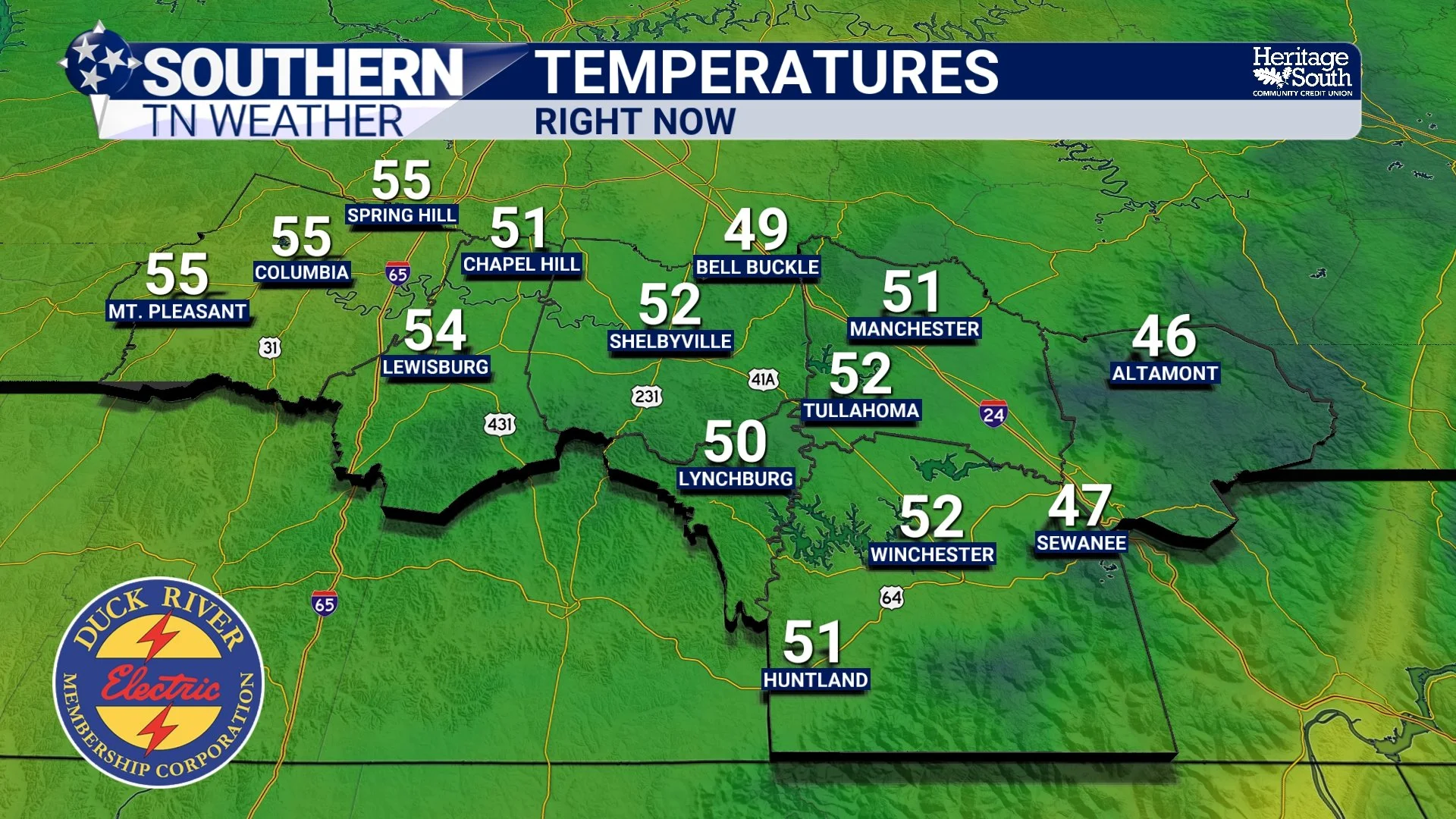
TEMPERATURES - RIGHT NOW
The Atmosphere Flips Again
By midweek, the pattern begins to resemble what we saw late last week. A large upper-level ridge (essentially a dome of warm air) will expand eastward from the Southwest into the Southeast. At the same time, surface winds turn more out of the south and southeast, allowing warmer air to be transported back into Tennessee. This process, known as warm air advection, will drive a steady increase in temperatures. Tuesday climbs back into the upper 60s, Wednesday reaches the low 70s, and by Thursday we’re right back into the 80s. That’s a fast turnaround, even by March standards.
Thursday: Another Shot at Record Warmth
Thursday is shaping up to be the warmest day of the week. With the ridge strengthening overhead and plenty of sunshine expected, temperatures will likely reach the low to mid 80s across Southern Middle Tennessee. That puts us within range of record highs, with roughly a 40 to 50 percent chance of tying or breaking records in parts of the Mid-State. This warmth isn’t just coming from the surface — temperatures a few thousand feet up in the atmosphere are also running well above normal. When that warmer air mixes down during the day, it helps push surface temperatures even higher.
It’s a very efficient setup for heating, and one we typically see later in the spring season.
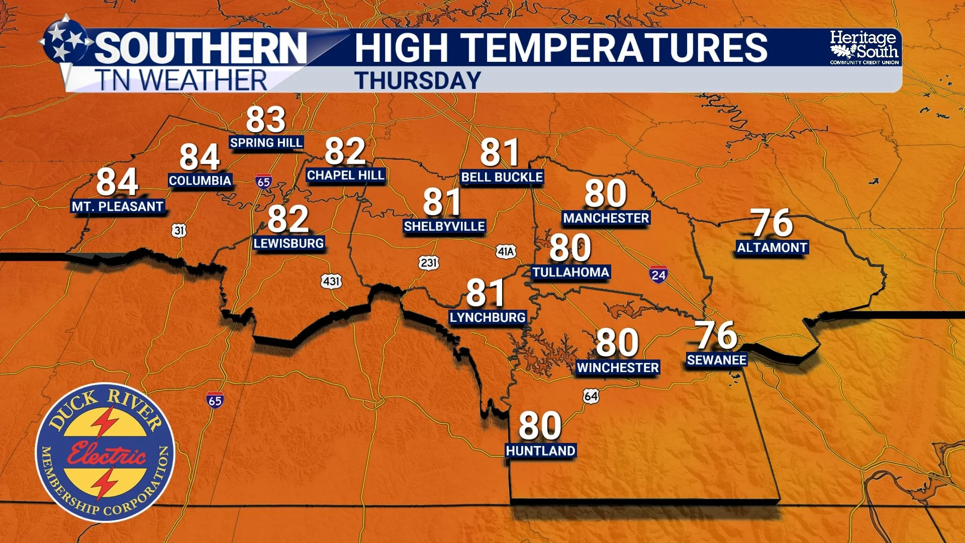
HIGH TEMPERATURES - THURSDAY
Why Rain Chances Stay Limited
Even though a couple of weak disturbances will move through the region during the week, the overall environment remains fairly dry. Those disturbances (often called shortwaves) will mainly bring periods of passing clouds Tuesday through Thursday. However, there simply isn’t enough moisture or large-scale lift in place to support widespread rain.
For most of Southern Middle Tennessee, the pattern stays dry through midweek.
Friday: A Weak Front Moves Through
Our next “real” chance for rain arrives on Friday as a cold front approaches the region. This system, however, looks fairly weak locally. Moisture will be limited, and the strongest dynamics will stay to our north. As a result, we’re looking at scattered showers and possibly a few thunderstorms, but nothing particularly widespread or intense.
At this time, severe weather is not expected, and rainfall totals appear on the lighter side — something we’ll continue to watch given how dry conditions have been.
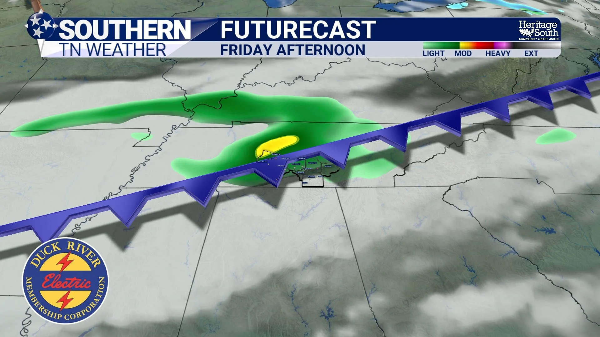
FUTURECAST - FRIDAY AFTERNOON
A Modest Cooldown Next Weekend
Behind the front, temperatures will cool slightly heading into the weekend. Saturday looks to be the cooler day, with highs likely in the 60s, before temperatures rebound back into the upper 60s to low 70s by Sunday. Overall, we remain near to slightly above normal, even after the front passes.
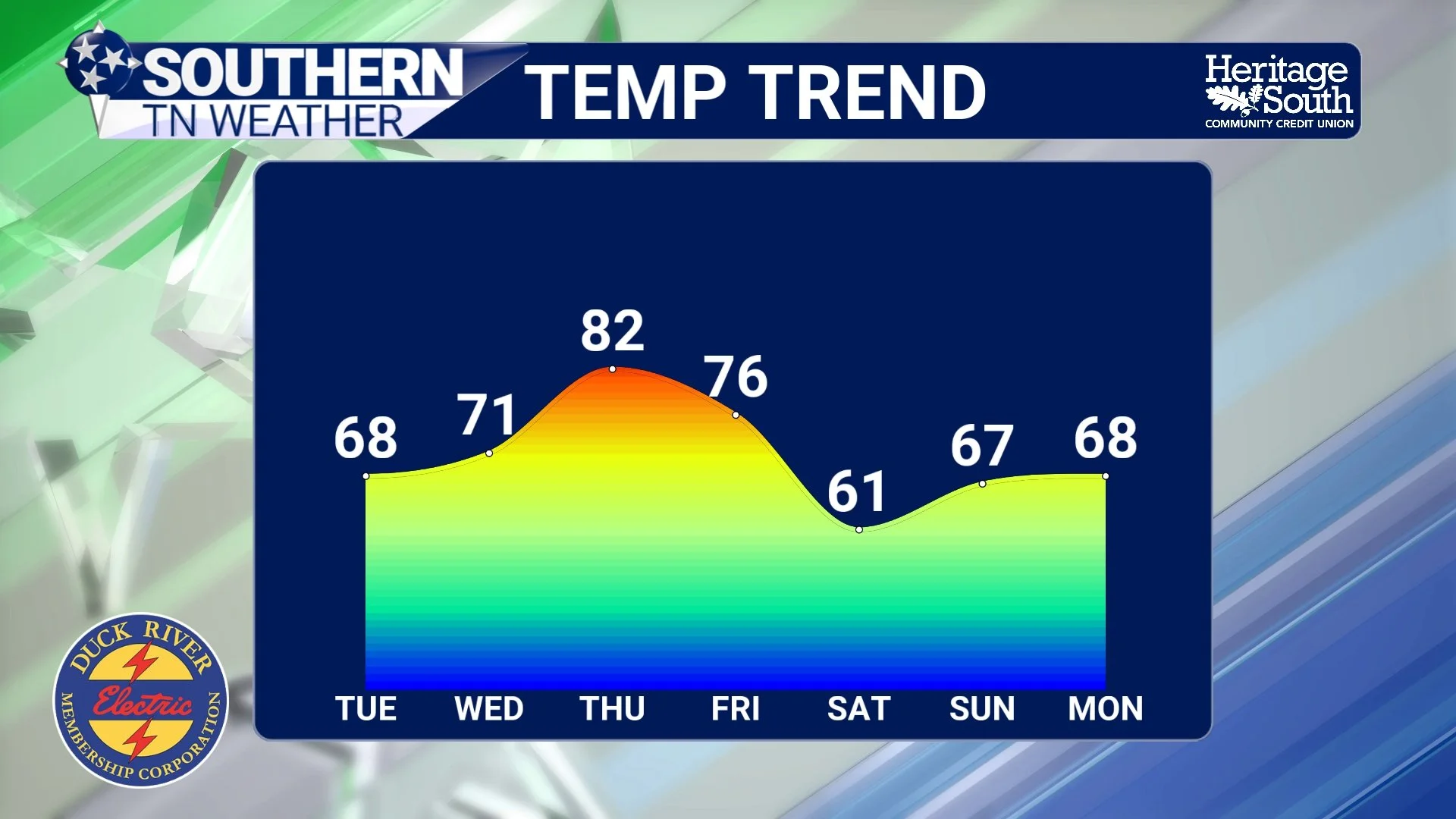
TEMPERATURE TREND - THIS WEEK
The Bottom Line 🧾
• Cooler today, but temperatures rebound quickly through midweek
• Highs return to the 80s Thursday with record warmth possible
• Dry conditions dominate through Thursday
• Scattered showers possible Friday with no severe weather expected
• Slight cooldown next weekend, but still mild overall
📰 Reminder: The Southern Tennessee Weather Blog, presented by Heritage South Community Credit Union, is updated Monday through Friday with fresh, locally tailored forecasts you can trust.