
Prolonged Cold Pattern Continues Across Southern Middle Tennessee

The Southern Tennessee Weather Blog is proudly presented by Heritage South Community Credit Union.
We Help When Others Won’t!
Visit https://www.heritagesouth.org/ today to see how HSCCU can help YOU!
Southern Middle Tennessee remains firmly locked in a winter pattern following last week’s storm, and while the active precipitation has ended, the impacts have not. The weather story now shifts into a prolonged post-storm phase defined by persistent cold, slow melting, and repeated nighttime refreezing. This is often the most deceptive part of winter events around here, because conditions may look improved during the afternoon, only to quietly deteriorate again after sunset.
On the larger scale, the eastern half of the country continues to sit beneath a broad upper-level trough. This keeps Arctic air entrenched across the region and prevents any meaningful warmup. Northwest flow aloft remains established, reinforcing cold air and maintaining below-normal temperatures through the remainder of the week.
Today Through Tonight: A Familiar Melt-Refreeze Cycle
Sunshine has finally returned in full force today, allowing temperatures to climb into the upper 30s and lower 40s across much of Southern Middle Tennessee. This is helping initiate some melting of snow and ice, particularly on darker, exposed surfaces. However, with a low January sun angle and lingering snow and ice cover, the melting process is slow and uneven. Many shaded areas, secondary roads, and locations under tree canopy remain icy, especially farther north and west in areas that saw appreciable ice accumulation.
This evening, skies will stay mostly clear and winds will relax as surface high pressure settles overhead. That combination is ideal for radiational cooling. Overnight lows are expected to fall back into the teens across most of the region, with a few single-digit readings possible in sheltered valleys and low-lying areas. Any moisture produced by today’s melting will refreeze quickly after sunset, leading to renewed slick spots and patches of black ice. Bridges, overpasses, and less-traveled roads remain especially vulnerable. This daily cycle of limited daytime melting followed by nighttime refreezing is expected to continue through much of the week.
Freezing Fog Potential and Secondary Concerns
Another subtle but important factor we are monitoring is the potential for fog development over the next couple of nights, especially tonight. With lingering snow and ice cover and temperatures falling well below freezing, any fog that becomes dense could freeze on contact with cold surfaces. This would further glaze roads, trees, and power lines and could locally worsen already sensitive conditions. While winds aloft may limit the extent of dense fog, even isolated pockets could create hazardous travel, especially in valleys and near bodies of water.
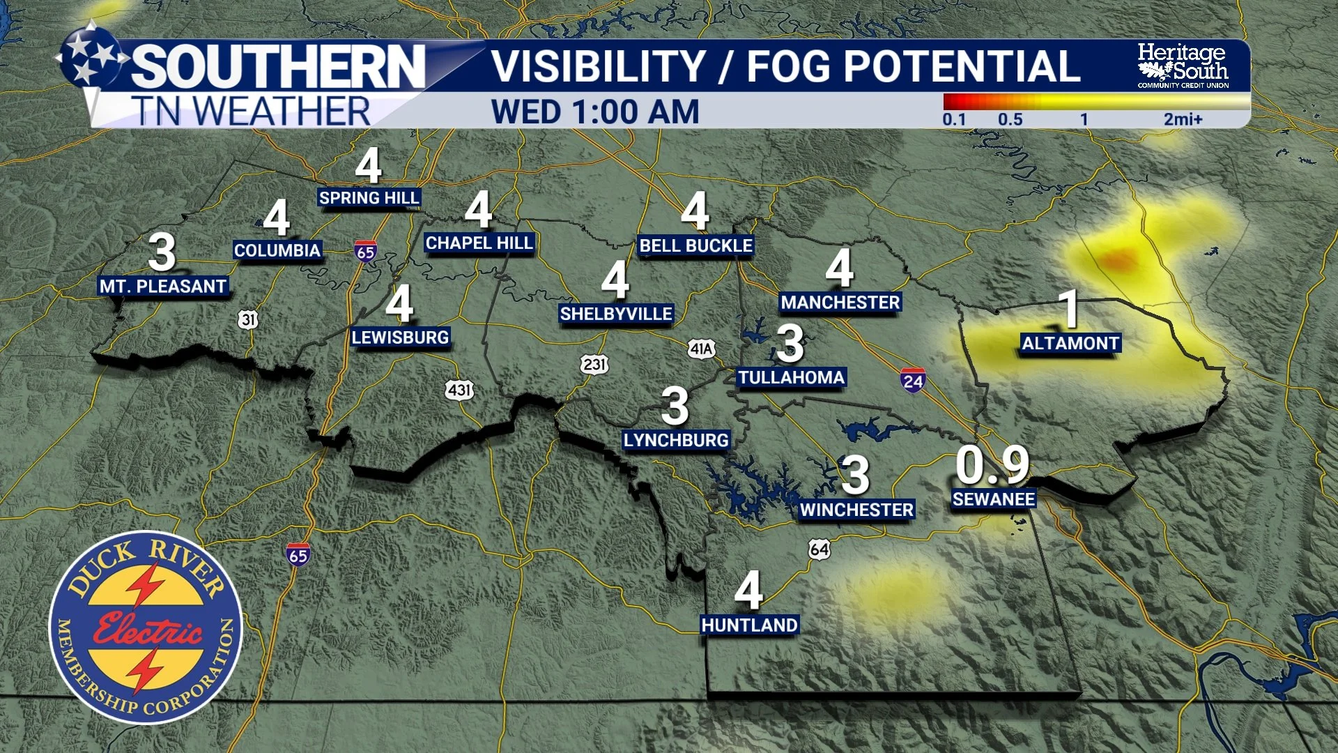
Visibility / Fog Potential - Tonight
Midweek: Quiet Weather, Ongoing Impacts
Wednesday and Thursday will remain dry as surface high pressure dominates. Skies will feature a mix of sun and passing high clouds, and afternoon highs will generally reach the upper 30s to lower 40s. Overnight lows will continue in the upper teens to lower 20s. Despite the sunshine, significant melting is not expected. Where snow and ice remain on the ground, temperatures and solar angle will not be sufficient to clear conditions quickly from roadways. Each night will continue to undo some of the daytime improvement. This is a classic post-storm cold regime where impacts linger well beyond the storm itself.
The one bit of good news is that things are already starting to return to more normal conditions in our southern and eastern areas that did not see appreciable ice and snow accumulation. Even there, however, some lingering travel impacts remain possible, especially overnight and early each morning.
Late Week: Watching a Weak Disturbance
There is increasing interest in a weak system that may approach the region late Friday into Friday night and potentially Saturday. Some guidance suggests light precipitation could brush parts of Middle Tennessee, while other solutions maintain a dry forecast. If precipitation does occur, forecast soundings support temperatures cold enough for snow. Moisture appears limited, and any accumulation would likely be light, but this period bears watching, especially given existing road conditions and the sensitivity of the region after the recent storm. I’m bringing out my “freak-out meter” once again (which has been a big hit over the past week) but this time it’s firmly in the “SNOW??? BLESS YOUR HEART…” category. This is NOT a milk and bread situation!
More certain than any precipitation chance, however, is another reinforcing surge of Arctic air late Friday into the weekend…
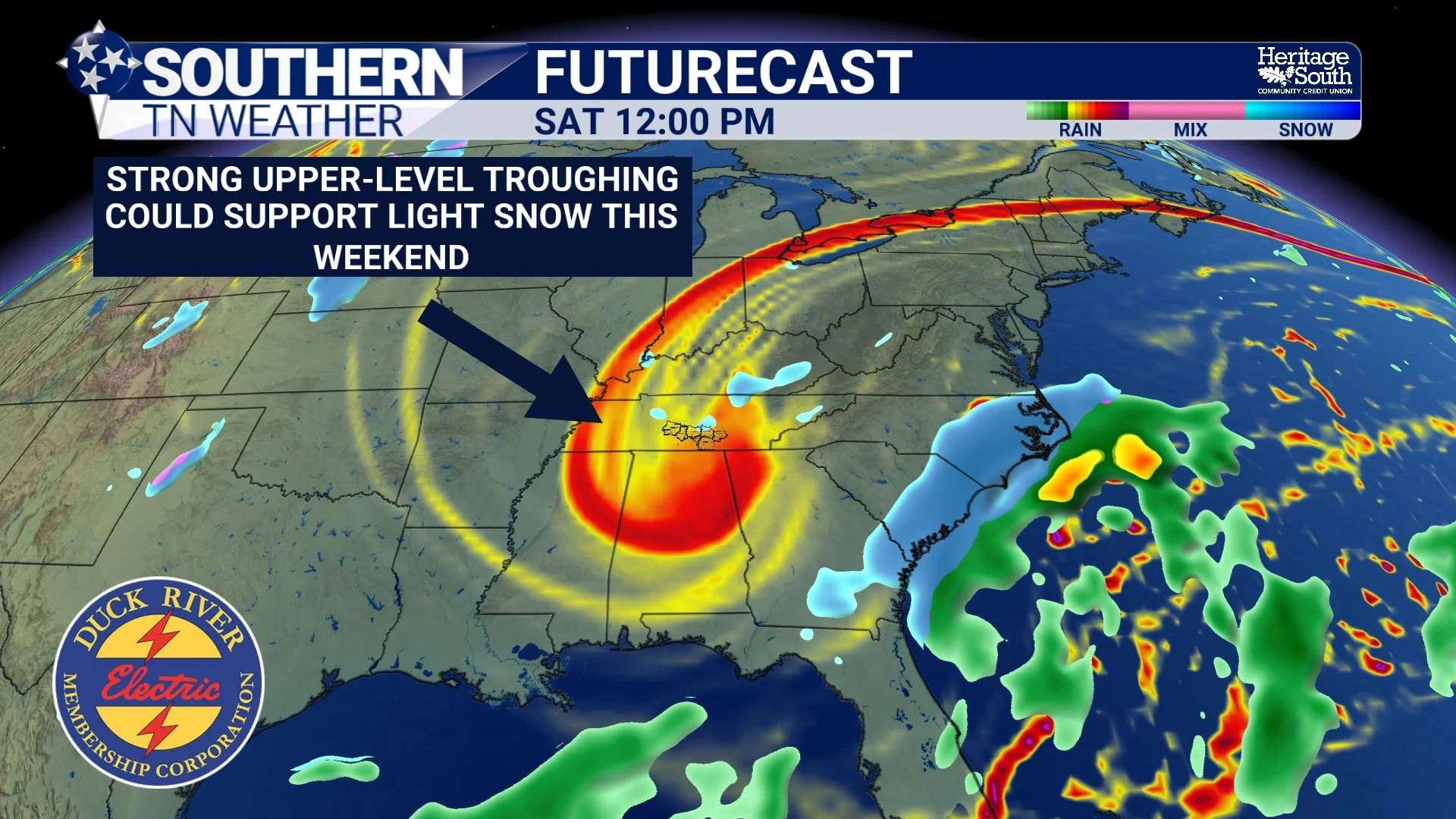
Upper-Level Trough this weekend
Another Arctic Push: The Cold Intensifies
Confidence continues to grow that another shot of cold air arrives this weekend. Probabilistic guidance still shows better than a 50 percent chance that portions of Southern Middle Tennessee fall to 5 degrees or colder Saturday morning. Saturday is currently expected to be the coldest day, with highs likely struggling through the 20s and gusty northerly winds producing dangerous wind chills. Saturday night into Sunday morning may bring another round of single-digit lows, especially in rural and sheltered areas.
With snow and ice still present, especially across our northwestern zones, radiational cooling efficiency will be enhanced. This means temperatures could locally run colder than forecast, and any remaining moisture on roads will remain frozen for extended periods. Even as skies clear next week, nighttime refreezing will continue to be a concern. This is often what happens in our region when a significant winter storm is followed by prolonged Arctic air.
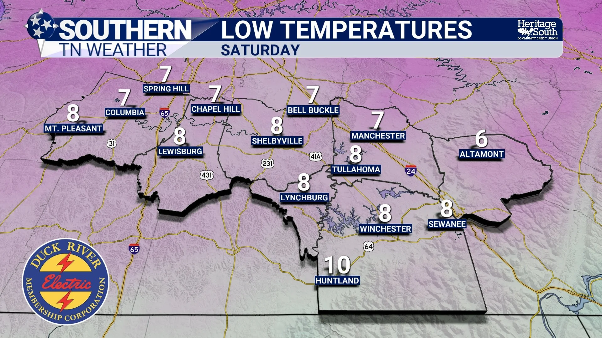
Low Temps - Saturday Morning
The Bottom Line 🧾
• Cold temperatures persist all week across Southern Middle Tennessee
• Overnight lows mainly in the teens, with some single digits possible
• Daytime melting will be limited and temporary, especially NW
• Refreezing and black ice are likely each night
• Patchy freezing fog is possible in some areas
• No widespread precipitation expected through midweek
• A weak system late Friday is being monitored for light snow potential
• Another Arctic surge this weekend may bring another round of dangerous cold
Winter weather impacts are ongoing even without falling precipitation. Continue using caution during the overnight and early morning hours, and prepare for dangerous cold as we move toward the weekend.
📰 Reminder: The Southern Tennessee Weather Blog (Presented by Heritage South Community Credit Union) is updated Monday through Friday with fresh, locally tailored forecasts you can trust