
Bitter Cold and Passing Flurries: What’s Next for Southern Middle Tennessee

The Southern Tennessee Weather Blog is proudly presented by Heritage South Community Credit Union.
We Help When Others Won’t!
Visit https://www.heritagesouth.org/ today to see how HSCCU can help YOU!
Southern Middle Tennessee remains firmly locked in a deep winter pattern, and the focus of this forecast is shifting away from storm recovery and fully into cold-weather hazards. While last weekend’s winter storm is now behind us, the atmosphere has not relaxed. In fact, the large-scale pattern aloft is becoming even more supportive of reinforcing Arctic air, and that will drive some of the coldest temperatures we have experienced so far this winter as we head into the upcoming weekend.
At the same time, a large upper-level low will drop south out of the Great Lakes late this week. While moisture with this feature looks limited, it will bring enough lift and instability to support periods of flurries and light snow showers, especially from Friday into early Saturday. Accumulations, if they occur, should remain light. However, with existing snow and ice still on the ground and dangerously cold temperatures in place, even minor snowfall could prolong slick conditions.
The Big Picture
On the large scale, the eastern United States remains beneath a broad upper-level trough, and that trough will sharpen further over the next 48 hours. As this happens, another strong lobe of Arctic air will surge southward into the Tennessee Valley late Friday into the weekend. This is not a shallow cold layer. It is a deep, continental air mass that will lock much of Southern Middle Tennessee below freezing for an extended period. At the same time, an intensifying upper low is forecast to drop southeast out of the Great Lakes and into the Ohio and Tennessee Valleys. As it swings through, it will steepen lapse rates aloft and increase upward motion. Moisture will be limited, but not absent. That combination favors scattered flurries and snow showers, particularly along and east of Interstate 65 and in the higher elevations of our eastern counties.
This is not a classic accumulating snowstorm setup for our area. It is a cold-dominant pattern driven primarily by upper-level dynamics rather than deep Gulf moisture. Systems like this most often favor the Cumberland Plateau, but that does not mean flakes will be confined there.
Today Through Thursday: Slow Melting, Refreezing, and Freezing Fog Risk
Cloud cover and patchy fog have limited solar heating today, and many locations across Southern Middle Tennessee have struggled to climb above freezing. That has significantly slowed the melting process. Ice and compacted snow remain widespread on secondary roads, shaded areas, and under tree canopy. This remains most noticeable in portions of northwest Bedford County, Marshall County, and Maury County, where ice accumulation from the weekend storm was greater.
Tonight, surface high pressure settles overhead and winds relax. With lingering ground moisture and widespread snow and ice cover, conditions become favorable for radiational cooling and fog development. Temperatures will fall back into the teens. In that environment, any fog that becomes dense could freeze on contact with cold surfaces. This raises concern for freezing fog, which can quietly add a thin glaze of ice to roads, bridges, power lines, and trees while also reducing visibility. This risk is highest west of the Plateau, including parts of Bedford, Marshall, Maury, and surrounding counties.
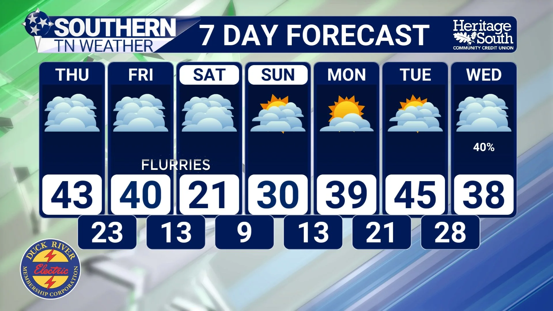
Thursday remains dry, but cold. Some southern locations may briefly touch the lower 40s, but many areas will stay in the 30s. Melting will remain limited and uneven in areas that have lots of ice and snow still on the ground, and once again temperatures will fall into the teens Thursday night, restarting the refreeze cycle.
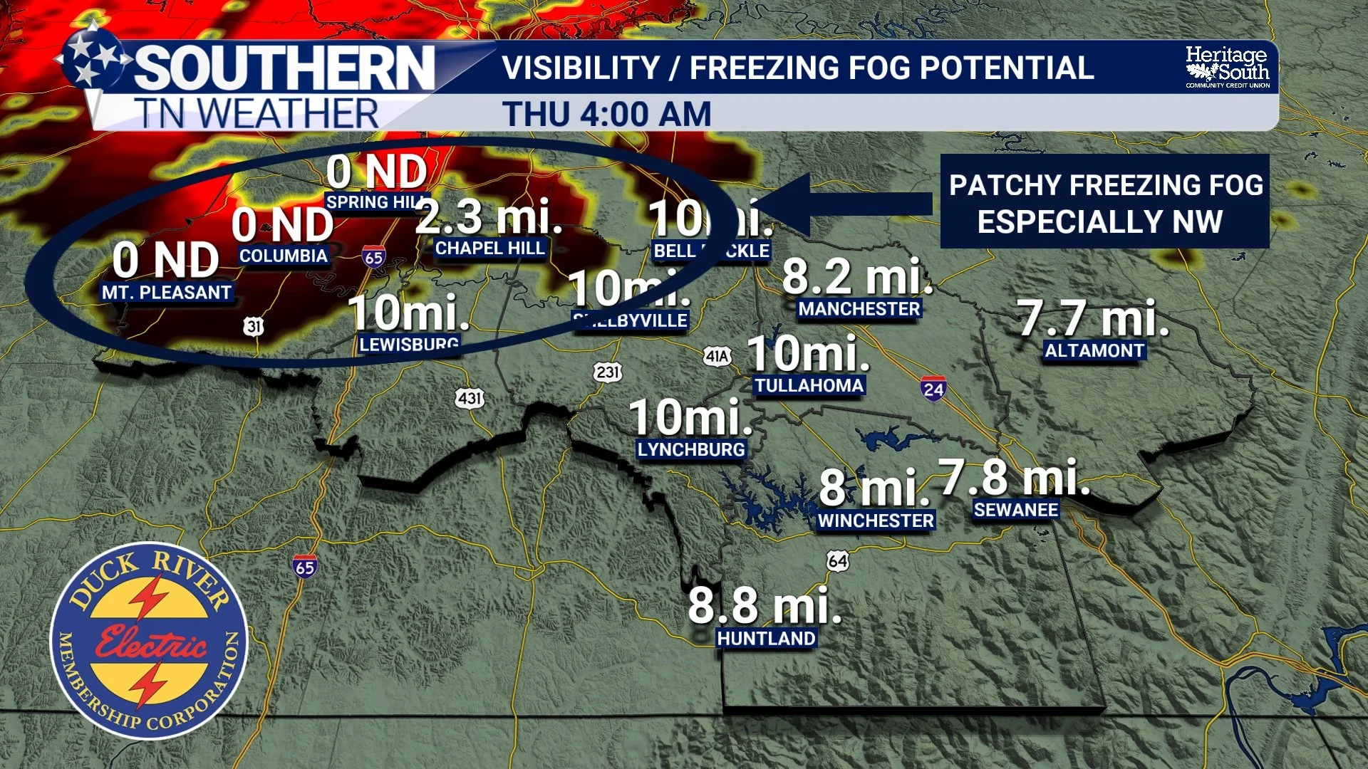
Freezing Fog Potential - Thursday Morning
Friday into Saturday: Watching for Flurries and Snow Showers
Attention then turns to late Friday into Saturday as the upper-level low drops into the region. As it approaches, cold air deepens through the entire atmospheric column. Forecast soundings across Southern Middle Tennessee indicate a fully sub-freezing profile, meaning any precipitation that develops will fall as snow.
Moisture availability remains the limiting factor. Current guidance supports scattered coverage and generally light precipitation amounts. However, lift increases Friday afternoon into Friday night, and low-level northwest flow favors upslope enhancement into the Cumberland Plateau. This places eastern portions of Southern Middle Tennessee in the best position to see measurable snowfall. At this time, the most realistic expectation is intermittent flurries and light snow showers, with localized minor accumulations possible, mainly east of I-65 and especially along the Plateau. Where snow occurs, totals are expected to remain under one inch. Still, any snowfall will be falling onto already compromised surfaces, and with temperatures well below freezing, there will be no opportunity for melting.
Winds will also be a factor. Northwest winds increase Friday and Saturday, which may help limit accumulation on some road surfaces, but they will also contribute to bitter wind chills and could produce localized blowing snow.
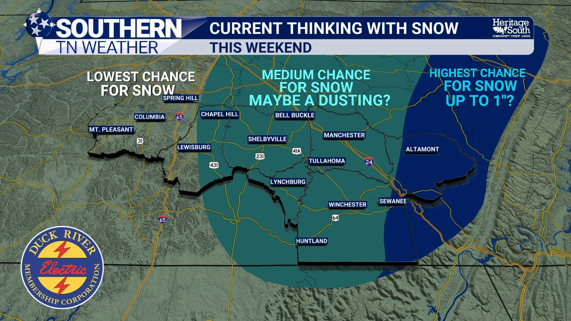
Current Thinking With Snow - This Weekend
The Primary Hazard: Dangerous and Prolonged Cold
While flurries may draw attention, the dominant hazard this weekend is extreme cold. Behind Friday’s frontal passage, Arctic air surges into Southern Middle Tennessee aggressively. Saturday morning and Sunday morning are both trending toward low teens and single-digit temperatures across much of the region, with some sheltered and rural locations possibly colder. At the same time, gradient winds will remain elevated, producing wind chills near or below zero.
Equally concerning is the duration of the cold. From Friday afternoon through at least Monday afternoon, much of Southern Middle Tennessee is expected to remain continuously below freezing for more than 60 hours. That kind of prolonged cold significantly increases the risk of lingering and worsening impacts from last week’s storm.
With snow and ice still on the ground, radiational cooling efficiency will be enhanced. This means temperatures could locally fall colder than forecast in some areas, particularly overnight.
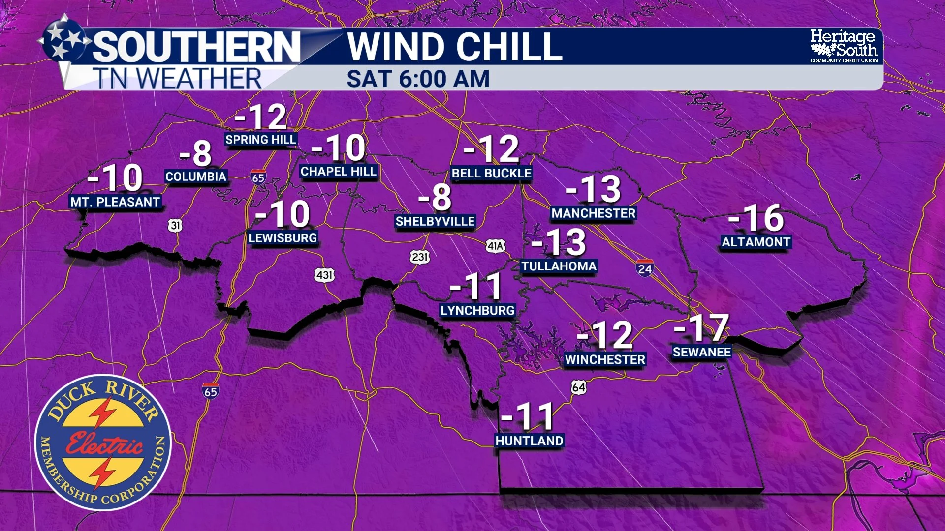
Wind Chill Forecast - This Weekend
When Do We Improve?
A slow moderation appears possible early next week. While nights will remain cold, daytime highs should gradually recover into the upper 30s and 40s by Monday and Tuesday, allowing more meaningful melting to finally begin. Until then, winter remains firmly in control across Southern Middle Tennessee.
The Bottom Line 🧾
• Southern Middle Tennessee remains locked in a deep winter pattern
• Freezing fog is possible tonight and early Thursday, adding new slick spots
• Very cold temperatures continue through the work week
• Low chance for flurries or light snow Friday into Saturday, especially east and on the Plateau
• Any accumulation would be light, but impacts could still occur
• Dangerous Arctic air arrives this weekend
• Single-digit lows are possible Saturday and Sunday mornings
• Wind chills near or below zero are likely
• Many areas may remain below freezing for more than 60 straight hours
• Black ice, frozen pipes, and cold-weather safety will be major concerns
📰 Reminder: The Southern Tennessee Weather Blog (Presented by Heritage South Community Credit Union) is updated Monday through Friday with fresh, locally tailored forecasts you can trust