
Peak Spring Heat Tomorrow… Then a Quick Pattern Reset

The Southern Tennessee Weather Blog is proudly presented by Heritage South Community Credit Union.
We Help When Others Won’t!
Visit https://www.heritagesouth.org/ today to see how HSCCU can help YOU!
We’re heading into the warmest part of this current stretch across Southern Middle Tennessee, but what’s just as important as the warmth itself is how the overall pattern is evolving. Thursday will likely bring another round of near-record temperatures, but this isn’t a stagnant pattern. Instead, it’s a classic late-March setup where warmth builds quickly, gets knocked back briefly, and then returns just as fast.
Why the Warmup Has Been So Efficient
The reason temperatures have climbed so quickly this week comes down to the larger-scale setup across the country. Right now, a longwave trough is positioned over the eastern United States, while a strong ridge is anchored over the western part of the country. Southern Middle Tennessee is sitting between these two features, which is often a “quiet zone” in the atmosphere.
At the surface, winds have shifted out of the south, and that’s allowing warmer air to be transported northward. At the same time, the ridge to our west is beginning to expand eastward, gradually taking control of the pattern. As that ridge builds overhead, it promotes sinking air. That sinking motion limits cloud development and allows for stronger sunshine during the day. Combine that with warmer air already present a few thousand feet above the ground, and you get a very efficient warming setup.
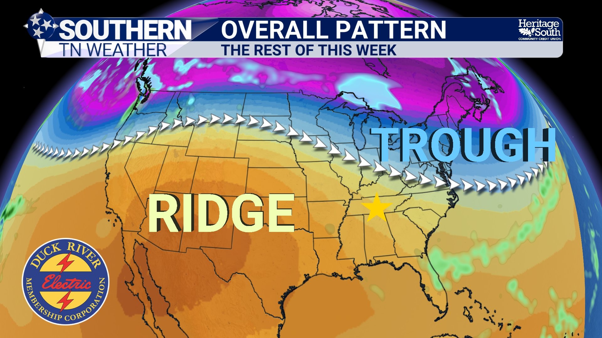
OVERALL PATTERN - REST OF THIS WEEK
Thursday: A Warm Peak
By Thursday, that ridge will be at its strongest influence over Middle Tennessee. Temperatures are expected to climb into the mid to upper 80s across Southern Middle Tennessee, especially west of the Plateau. That puts us right on the doorstep of record territory for late March.
This warmth isn’t just surface-based. Temperatures at around the 850mb level, roughly 5,000 feet above the ground, are running well above normal. With strong daytime mixing, that warmth is able to transfer down to the surface, helping push temperatures higher than you might expect for this time of year. It’s a setup that feels much more like late April or even May than mid-March.
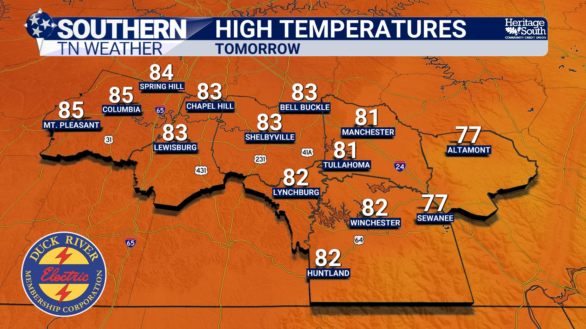
HIGH TEMPERATURES - THURSDAY
Why Friday’s System Looks Underwhelming
After Thursday’s peak warmth, a cold front will drop south into the region on Friday. At first glance, that might sound like a better opportunity for rain, but this system is missing a few key ingredients.
The front itself is relatively weak by the time it reaches us, and the best dynamics will remain well to our north. In addition, the atmosphere locally lacks strong instability and has fairly poor lapse rates, which limits vertical development in clouds and storms. This is what meteorologists often refer to as an “anafrontal” setup, where most of the lift and precipitation occur behind the front rather than ahead of it. The result is a higher chance for showers, especially north of Interstate 40, but with generally light rainfall totals. Many areas across Southern Middle Tennessee may only see a brief shower, and that’s IF anything at all…
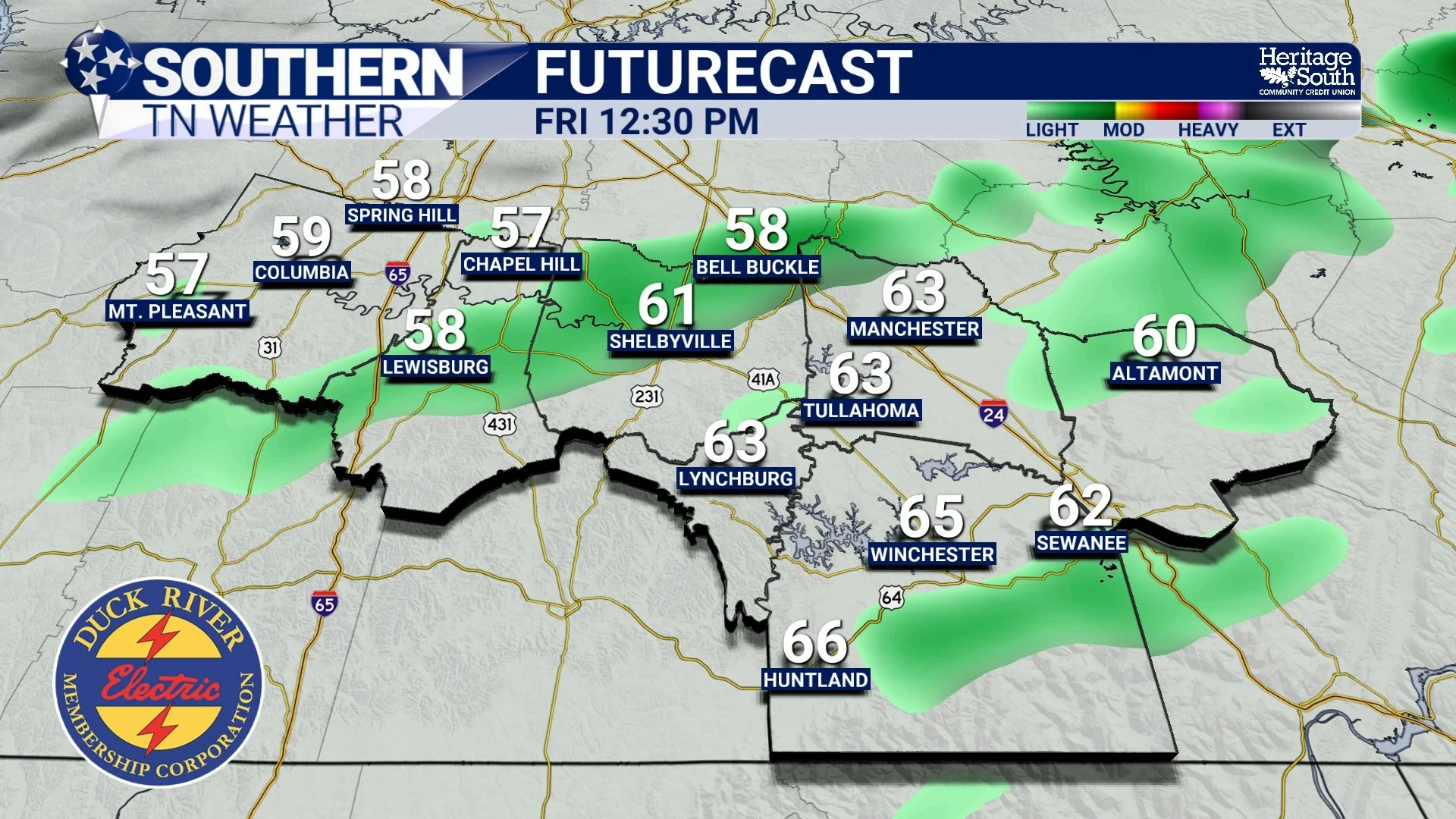
FUTURECAST - FRIDAY AFTERNOON
A Quick Cooldown… Then Right Back to Warm
Behind the front, temperatures will take a noticeable step back on Saturday. Highs will likely fall into the upper 50s to low 60s, driven by cooler air moving in from the north. It will feel like a sharp contrast compared to Thursday, even though it’s actually closer to normal for this time of year. But that cooler air doesn’t stick around long…
By Sunday, winds begin turning back out of the south, and the pattern starts to warm again. Another ridge builds into the Southeast early next week, allowing temperatures to climb back into the 70s and eventually back into the 80s.
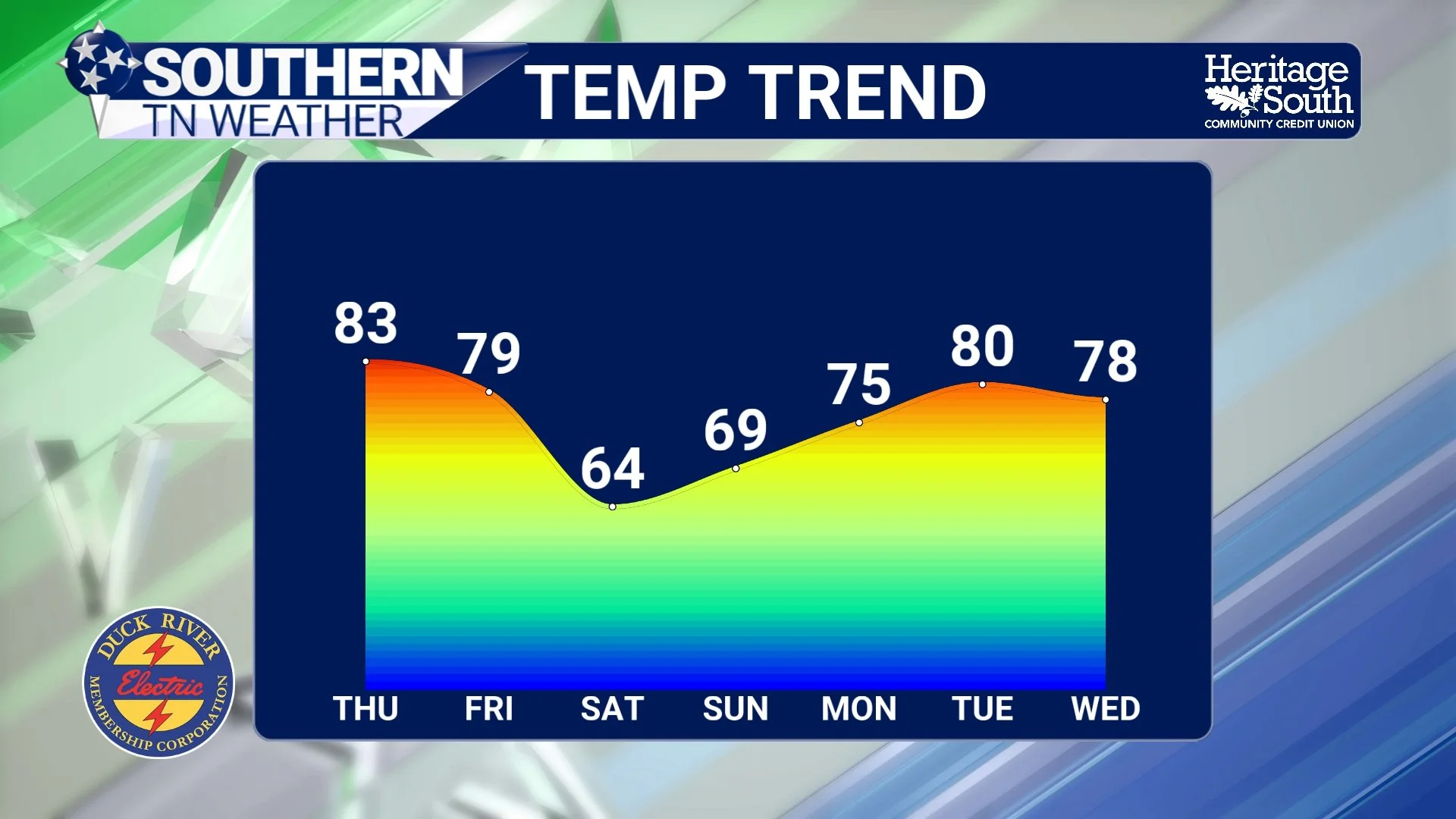
TEMPERATURE TREND - NEXT 7 DAYS
The Bigger Picture
This is a very typical late-March pattern at least in terms of overall temperatures. We’re in that time of year where the atmosphere is still active enough to send fronts through the region, but not strong enough to hold cooler air in place for very long. At the same time, ridging can rebuild quickly, allowing warmth to return in a hurry. One thing that isn’t typical though is the lack of precipitation, which we do need.
The result is a cycle of quick warmups, brief cooldowns, and often limited rainfall. It’s a pattern that favors temperature swings more than it does widespread precipitation.
The Bottom Line 🧾
• Thursday brings near-record warmth with highs in the mid to upper 80s
• A cold front moves through Friday with scattered showers, mainly north of I-40
• Rainfall will be light and limited for most areas
• Cooler air arrives Saturday with highs back into the 50s and 60s
• Temperatures rebound quickly Sunday and return to the 80s early next week
📰 Reminder: The Southern Tennessee Weather Blog, presented by Heritage South Community Credit Union, is updated Monday through Friday with fresh, locally tailored forecasts you can trust.