
More Rain Ahead… But We May Finally See A Pattern Change Soon

The Southern Tennessee Weather Blog is proudly presented by Heritage South Community Credit Union.
We Help When Others Won’t!
Visit https://www.heritagesouth.org/ today to see how HSCCU can help YOU!
If it feels like Southern Middle Tennessee has been stuck in an endless cycle of clouds, humidity, and popup downpours lately… you’re not imagining things. After one of the driest starts to spring we’ve seen in awhile, the weather pattern has COMPLETELY flipped over the last couple of weeks. Instead of fighting drought and dry cold fronts, we’re now dealing with a tropical-feeling atmosphere capable of producing repeated rounds of showers and thunderstorms almost daily.
The good news? The rain is continuing to help chip away at drought conditions across the region. The bad news? We’re probably all getting a little tired of looking at gray skies and dodging afternoon thunderstorms.
Why Today Felt Different
One thing many people probably noticed today was the return of actual sunshine for parts of the afternoon. For the first time in several days, breaks in the cloud cover allowed temperatures to climb into the upper 70s and lower 80s across parts of Southern Middle Tennessee. That sunshine also helped destabilize the atmosphere once again after this morning’s rain activity weakened and shifted northward.
Earlier today, a feature called an MCV (or Mesoscale Convective Vortex) moved through the Tennessee Valley. These are basically leftover spinning disturbances generated by previous thunderstorm complexes. Even after the main storms weaken, the circulation itself can linger for hours and sometimes even an entire day. MCVs are common in humid summertime-style patterns like the one we’re currently in, and they often help act as a “focus point” for new showers and thunderstorms to redevelop later in the day.
That’s one reason scattered storms fired back up this afternoon despite a quieter start to the day.
Why Storms Have Become So “Pulse-Like”
Unlike classic spring severe weather outbreaks where storms organize into large squall lines, this current pattern is favoring what meteorologists call “pulse convection.” Basically, storms rapidly build upward during peak daytime heating, dump heavy rainfall, produce lightning and gusty winds, then collapse fairly quickly once they run out of energy.
The reason this keeps happening is because instability remains decent, but wind shear remains weak. Wind shear is what helps storms organize and sustain themselves for longer periods of time. Without strong shear, thunderstorms struggle to maintain structure and instead behave more like isolated tropical downpours. That’s why we continue hearing phrases like “no organized severe weather expected” in forecast discussions despite storms producing torrential rainfall and occasional gusty winds.

The Atmosphere Still Looks Very Tropical
Even though widespread severe weather is not expected, the atmosphere remains incredibly moisture-rich for late May. Forecast PWAT values (or precipitable water values) continue running between 1.6 and 1.8 inches, which is near the upper end of climatological values for this time of year. In simpler terms: the atmosphere is loaded with moisture.
That means almost any thunderstorm that develops is capable of producing very heavy rainfall in a short amount of time. In addition, Dew Points are in the 70s which reinforces the fact that this airmass is VERY moist.
One interesting thing about this setup is how warm overnight temperatures have stayed recently. Normally during spring, clear skies and lower humidity allow temperatures to cool fairly efficiently after sunset. But with all this moisture trapped in the atmosphere, nighttime cooling becomes much harder. Humidity acts almost like insulation, keeping overnight lows stuck in the upper 60s instead of dropping into the 50s like we’d normally expect this time of year.
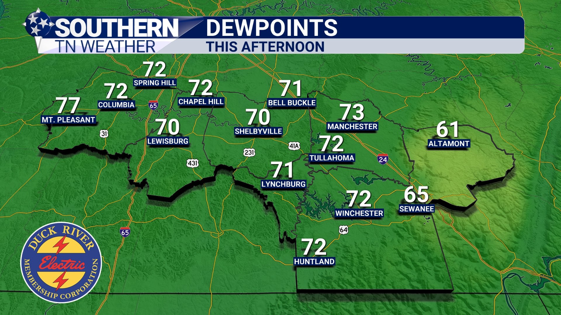
DEW POINTS - THIS AFTERNOON
Rain Totals Continue Adding Up
Some areas across Middle Tennessee are now approaching or even exceeding 6 inches of rainfall over the past week alone. Thankfully, because soils started out extremely dry, widespread river flooding has largely been avoided so far. The ground has been able to absorb a good portion of the rainfall initially. However, that buffering effect slowly decreases over time.
As additional rounds of rain continue through the rest of this week, the risk for localized flooding issues gradually increases — especially in low-lying areas, poor drainage spots, and locations that repeatedly get stuck under thunderstorms. Forecast guidance still suggests another 1 to 3 inches of rainfall through the end of the week, with the highest totals generally favored closer to the Alabama state line.
Localized higher amounts remain possible where storms repeatedly move across the same areas.
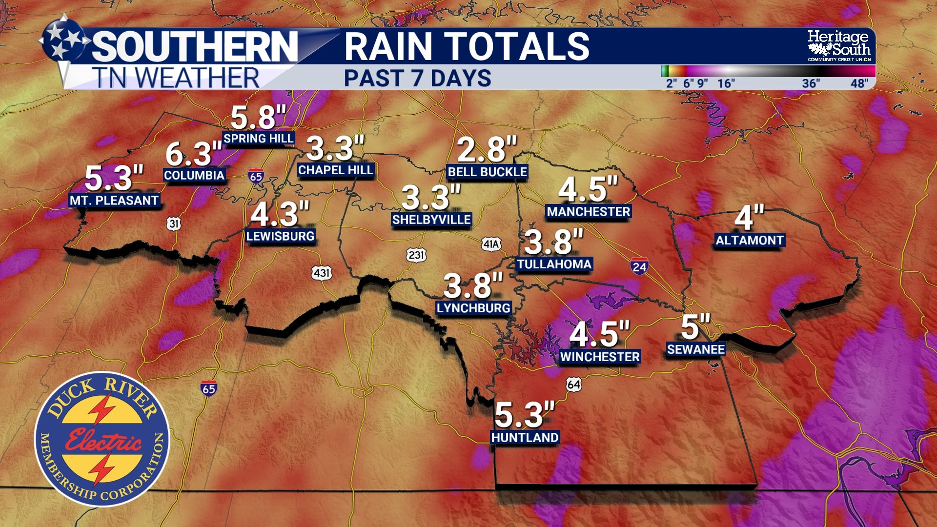
RAIN TOTALS - PAST 7 DAYS
A Drier Pattern Is Finally Trying To Develop
There IS at least some encouraging news buried in the longer-range forecast. We’re are beginning to see signs that the overall upper-level pattern may finally begin shifting by late this week into the weekend. A developing 500mb ridge (essentially an area of higher pressure in the upper atmosphere) is expected to slowly build into the Southeast. That won’t completely eliminate rain chances, but it SHOULD begin reducing overall storm coverage and helping us transition away from this nonstop dreary pattern.
Notice the wording carefully though: driER, not completely dry.
Humidity and instability will still be around, meaning isolated afternoon thunderstorms can still develop, especially during peak daytime heating. But compared to the nearly daily widespread rain coverage we’ve dealt with lately, next week should feature more sunshine and fewer storms overall. And honestly… Southern Middle Tennessee is probably ready for a little sunshine again!
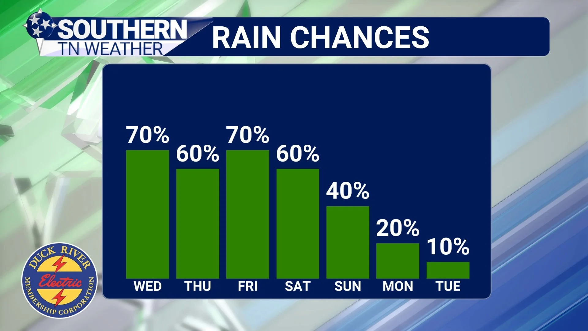
RAIN CHANCES - NEXT 7 DAYS
The Bottom Line 🧾
Scattered showers and thunderstorms continue daily through the rest of the week.
No organized severe weather is expected, but a few stronger storms remain possible during the afternoon and evening hours.
Heavy rainfall remains the primary concern with this pattern.
Some areas have already received nearly 6 inches of rain over the past week.
Another 1 to 3 inches of rain is possible through the end of the week.
Localized flooding concerns will continue where storms repeatedly track over the same locations.
A gradually drier pattern may finally begin developing by the weekend into next week.
📰 Reminder: The Southern Tennessee Weather Blog, presented by Heritage South Community Credit Union, is updated Monday through Friday with fresh, locally tailored forecasts you can trust.
