
Not All Rain Is Created Equal: What Makes a GOOD Soaking Rain?

The Southern Tennessee Weather Blog is proudly presented by Heritage South Community Credit Union.
We Help When Others Won’t!
Visit https://www.heritagesouth.org/ today to see how HSCCU can help YOU!
If you’ve been following Southern Tennessee Weather over the past few days, you know we’ve started talking more about our recent dry stretch. Despite what was a pretty wet summer overall, rainfall has become much harder to come by lately. Most of Southern Middle Tennessee is now running roughly 1–2 inches below normal over the past 30 days, with some localized areas doing a little better thanks to the scattered thunderstorms we’ve seen recently.
Naturally, that means we’re ready for some rain. And thankfully, we have several opportunities showing up in the forecast over the next few days. But here’s an interesting question: If we need an inch of rain, does it really matter HOW we get that inch?
Absolutely! An inch of rain falling gradually over several hours can have a very different impact than an inch dumped by a thunderstorm in 20 minutes. Both may put exactly 1.00” in your rain gauge, but what happens to that water once it reaches the ground can be dramatically different. That’s why meteorologists, farmers and gardeners sometimes talk about getting a good, old-fashioned “soaking rain.”
Getting Rain Into the Ground Is What Really Matters
When rain reaches the surface, some of that water begins soaking into the soil through a process called infiltration. Once there, it can replenish soil moisture available to grass, crops, trees and other vegetation, with some eventually working its way deeper into the ground. The catch is that soil can’t necessarily absorb an unlimited amount of water instantaneously.
Think about slowly pouring a glass of water onto a dry sponge. Give it enough time, and quite a bit of that water can be absorbed. Dump the entire glass onto it at once, however, and you’re probably going to have water running across the counter. Soil is considerably more complicated than a kitchen sponge, but the basic idea is similar. If rainfall occurs at a manageable rate, the ground has more time to accept that water. If an intense thunderstorm dumps tremendous amounts of rain faster than the soil can absorb it, the excess begins running across the surface and eventually into ditches, creeks and streams.
Imagine two farms each receiving exactly one inch of rain. One gets its inch gradually over six hours, while the other receives the entire inch during a torrential 25-minute thunderstorm. The rain gauges may show exactly the same amount afterward, but that doesn’t necessarily mean the same amount of useful moisture made it into the soil. Of course, there are plenty of variables involved. Soil type, vegetation, slope, land use, existing soil moisture and rainfall intensity all influence how quickly water can infiltrate. Sandy soils behave differently from clay-rich soils, while a healthy grassy field behaves much differently from compacted ground or pavement.
And believe it or not, extremely dry ground can sometimes create problems of its own. During prolonged dry periods, some soils can become hard, crusted or compacted near the surface. If torrential rain suddenly arrives, the rainfall rate may overwhelm the ground’s ability to absorb the water quickly enough. Instead of immediately soaking deeply into the soil, some of it runs off. That’s one of the strange realities of weather: an area can desperately need rain and still experience localized flooding when the rain finally arrives.
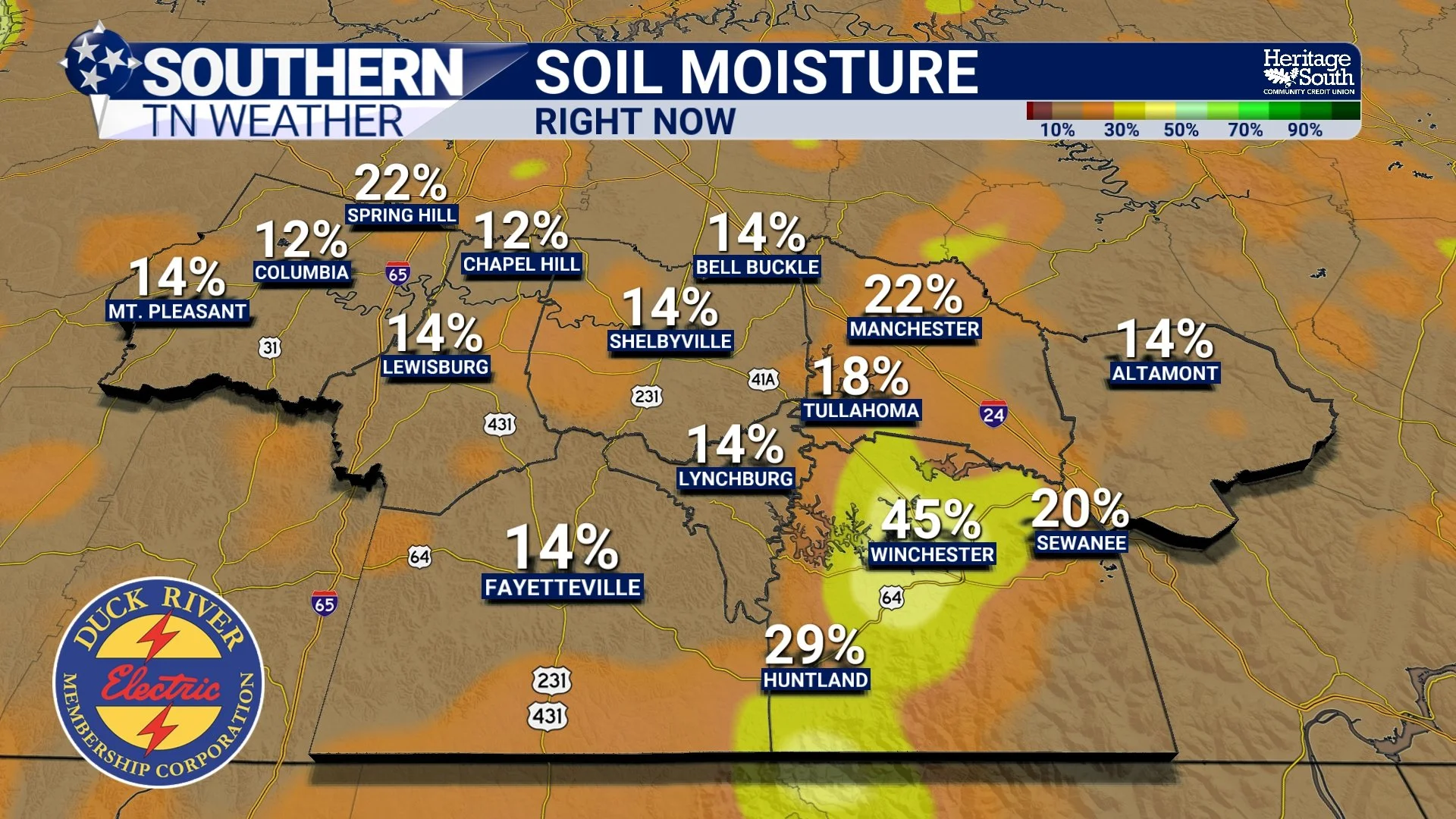
SOIL MOISTURE - RIGHT NOW
Why One Big Thunderstorm Doesn’t Necessarily Fix a Dry Spell
This also explains why scattered summertime thunderstorms aren’t always the drought-busters we’d like them to be. We’ve seen a great example of that around Southern Middle Tennessee recently. One community gets absolutely hammered by a thunderstorm while another town five or ten miles away barely gets enough rain to wet the driveway. That’s how we end up with those little “holes” in rainfall-deficit maps where one area is doing considerably better than its neighbors.
Repeat that process several times over a month and rainfall totals can become dramatically different over surprisingly short distances. That’s why widespread dry conditions are generally better improved by widespread rainfall rather than relying exclusively on scattered thunderstorms. A broad area of moderate rain lasting several hours can distribute moisture much more evenly across the region. Pop-up thunderstorms, meanwhile, may be extremely generous to one neighborhood and completely skip the next.
There’s another misconception worth clearing up while we’re here. If an area is running two inches below normal, that doesn’t necessarily mean one two-inch thunderstorm suddenly fixes everything. A rainfall deficit simply compares how much precipitation has actually fallen with how much would normally be expected over a certain period. Meanwhile, the climatological clock keeps running. While we’re trying to make up for rainfall we missed previously, additional rain would normally be falling during the days and weeks ahead. If we get one tremendous storm followed by another few weeks of dry weather, the deficit can quickly begin growing again.
Rainfall deficits also aren’t exactly the same thing as soil moisture, groundwater levels or drought classifications. All of those are related, but they measure different pieces of the overall moisture picture. That’s why recovering from a meaningful dry stretch usually isn’t about getting one monster thunderstorm. What we’d really like is a return to a pattern where beneficial rainfall occurs periodically over several weeks. In other words, I’d much rather see Mother Nature give us several rounds of manageable rainfall than attempt to erase the entire deficit between 4:15 and 5:00 one afternoon.
So What Does a GOOD Soaking Rain Look Like?
There isn’t one magical rainfall rate or total that’s perfect for every situation, but generally speaking, we’re looking for rainfall that is widespread, reasonably steady and slow enough that a substantial portion of the water has time to soak into the soil. And ideally, we’d like it to happen more than once. Several rounds of beneficial rainfall separated by enough time for the water to infiltrate can do much more for increasingly dry conditions than one tremendous cloudburst followed by another long dry stretch.
That doesn’t mean thunderstorms aren’t helpful. If your backyard picks up an inch from a storm, you’re certainly not going to hear me complain about it. But when we’re talking about improving dry conditions across an entire region, where the rain falls and how quickly it falls can matter almost as much as the final number inside the rain gauge.
That’s especially important as we head into the next several days, because we finally have more rain opportunities entering the forecast. Unfortunately, it still looks like Mother Nature may spread those rainfall totals rather unevenly.
STNWX - TITLE GRAPHIC
More Rain Opportunities Are Finally Coming
Before those rain chances increase, we’ve got another hot day to get through across Southern Middle Tennessee. High pressure remains in control today, keeping temperatures well into the 90s. The most significant heat is focused farther north and west across Middle Tennessee, while Southern Middle Tennessee and the Tennessee Valley remain quite warm as well. Our pattern begins changing Thursday as high pressure weakens and a front approaches the region. Shower and thunderstorm chances begin increasing during the afternoon, although the best opportunity initially favors areas farther north. Rain and storm coverage should become more widespread Thursday evening into Friday as the front settles farther into the region.
And this ties directly back into everything we’ve talked about today. Atmospheric moisture will increase substantially, meaning thunderstorms that develop could become efficient rainfall producers. Some storms may move rather slowly, which could lead to locally heavy rainfall. That would certainly be beneficial in some places, but it could also create another situation where rainfall totals vary tremendously over short distances. One community could receive a very healthy soaking while another several miles away receives considerably less.
The severe-weather threat with this system currently looks low, although the strongest storms could produce gusty winds. As always, we’ll keep an eye on trends as the system gets closer. Scattered shower and thunderstorm opportunities should continue Friday and periodically into the weekend as additional weak disturbances move through the region. Temperatures won’t exactly turn cool, either. Highs generally remain in the upper 80s and lower 90s, with some locations potentially creeping back toward the middle 90s as we move deeper into the weekend.
So yes, we finally have several opportunities for rain. Now we just need Mother Nature to spread the wealth instead of giving one backyard two inches and leaving the neighbor’s rain gauge empty.
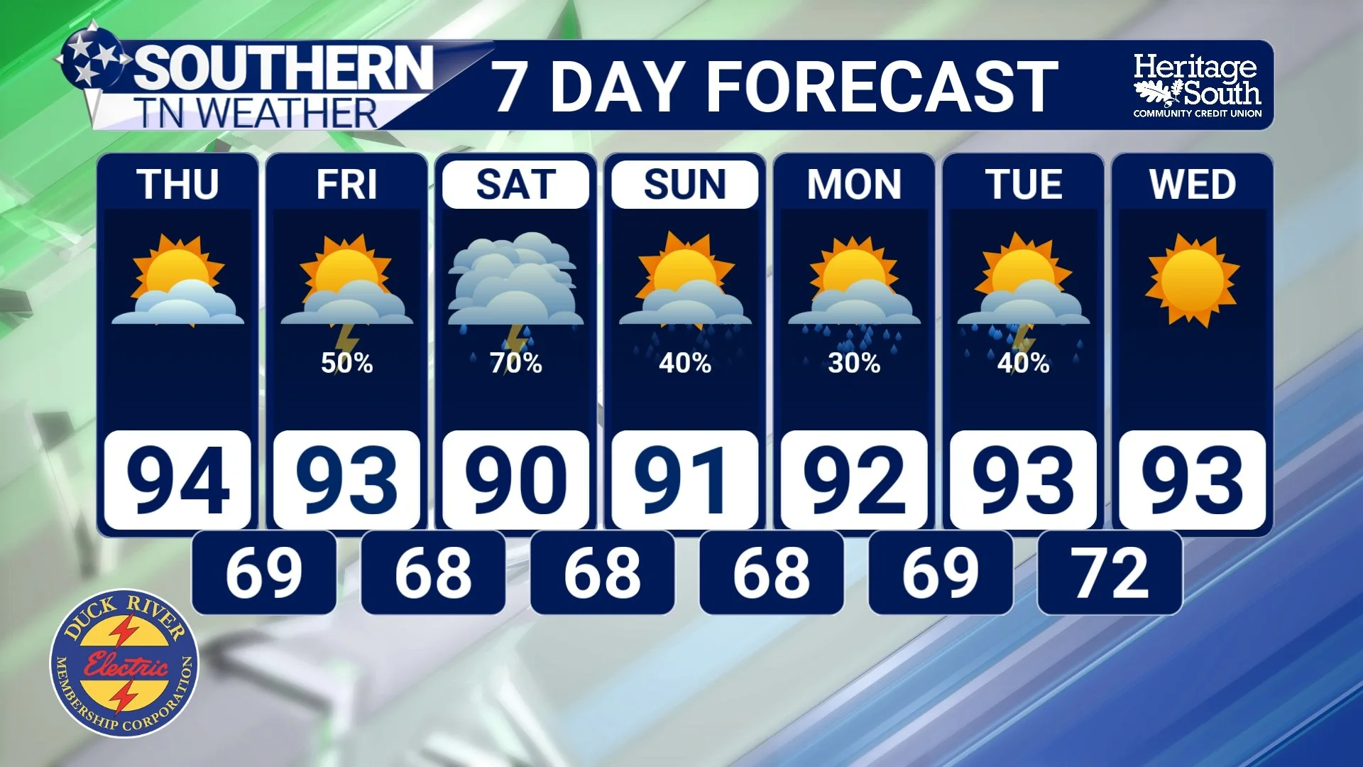
STNWX 7-DAY FORECAST
The Bottom Line 🧾
Not all rain is equally beneficial. How quickly it falls can matter almost as much as how much falls.
A slower, steadier rain generally gives more water an opportunity to infiltrate into the soil.
Torrential rainfall can exceed the ground’s ability to absorb water, resulting in more runoff.
Extremely dry or compacted ground can sometimes initially struggle to absorb very heavy rainfall.
Scattered thunderstorms can create huge differences in rainfall totals over only a few miles.
A 2-inch rainfall deficit doesn’t necessarily mean one 2-inch storm completely fixes the problem.
Several rounds of widespread, manageable rainfall are generally much more beneficial during a prolonged dry stretch.
Warm weather continues, with temperatures remaining above normal.
Rain chances increase Thursday, becoming more widespread Thursday evening into Friday.
Additional scattered showers and thunderstorms remain possible through the weekend.
Some storms could produce locally heavy rainfall, meaning rainfall totals may once again vary considerably from one community to another.
📰 Reminder: The Southern Tennessee Weather Blog, presented by Heritage South Community Credit Union, is updated Monday through Friday with fresh, locally tailored forecasts you can trust.
