
A Much Needed Pattern Change… Rain Returns This Week

The Southern Tennessee Weather Blog is proudly presented by Heritage South Community Credit Union.
We Help When Others Won’t!
Visit https://www.heritagesouth.org/ today to see how HSCCU can help YOU!
After a stretch of warm, dry, and at times fire-prone weather across Southern Middle Tennessee, the overall pattern is beginning to shift in a meaningful way. At the surface, today still feels quiet and comfortable. But higher up in the atmosphere, changes are already underway that will bring multiple chances for rain (and a much-needed break from the dryness) as we move deeper into the week.
The Calm Before the Pattern Shift
For now, we remain in what meteorologists call a zonal flow pattern, where winds in the upper levels of the atmosphere move generally west to east in a relatively straight line. This type of pattern tends to favor:
Mild temperatures
Limited large-scale storm systems
More subtle, weak disturbances
That’s exactly what we’re seeing today and into Tuesday. Southerly winds near the surface are helping to transport warm, slightly more humid air into the region, while a few weak ripples in the flow aloft are producing clouds at times. Still, there’s just not enough lift or organization in the atmosphere to generate widespread rainfall. As a result, we stay dry through Tuesday, with highs climbing into the upper 70s to lower 80s.
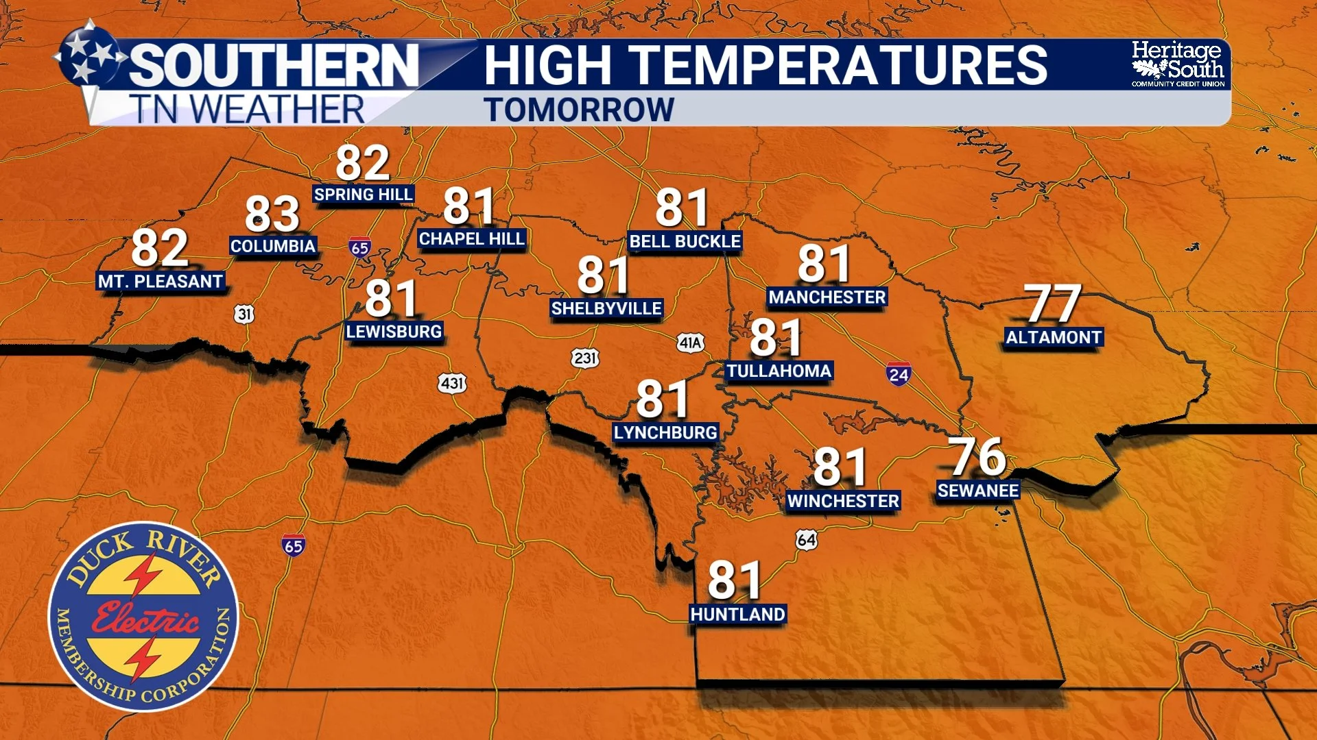
HIGH TEMPERATURES - TOMORROW
What Changes Midweek
The bigger shift begins on Wednesday, and it starts above our heads. The upper-level pattern transitions from zonal flow to southwesterly flow aloft, which is a much more active setup. This happens as a developing storm system over the Plains begins to influence the region, while ridging strengthens to our east. That configuration does two important things… First, it opens the door for multiple disturbances (shortwaves) to move through the Tennessee Valley. These act as triggers for rising motion in the atmosphere. Second, it taps into a deeper connection to Gulf moisture. With continued southerly flow, the atmosphere becomes increasingly moist, which is critical for precipitation.
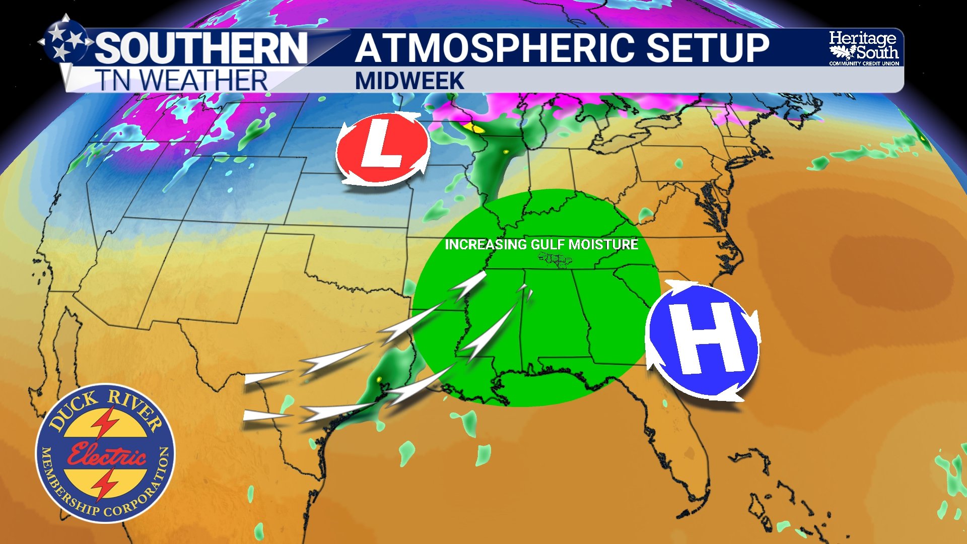
ATMOSPHERIC SETUP - MIDWEEK
Why Storms Will Be Limited in Strength
Even though rain chances increase, this is not shaping up to be a classic severe weather setup. When we look at the ingredients needed for severe storms (instability, shear, and lift) this pattern is lacking in a couple key areas. Instability values, measured as CAPE, are expected to remain relatively low, generally only a few hundred J/kg. That limits how much energy storms have to work with. At the same time, lapse rates are fairly weak, meaning the atmosphere doesn’t cool rapidly with height. This reduces the ability for strong updrafts to develop.
Wind shear is present, but modest (generally around 25 knots) which is enough for some organization, but not typically enough for severe weather in this kind of setup. The result is what we call “garden variety thunderstorms” — scattered storms that produce rain, occasional lightning, and maybe a brief gust of wind, but nothing particularly intense.
A Multi-Day Rain Setup
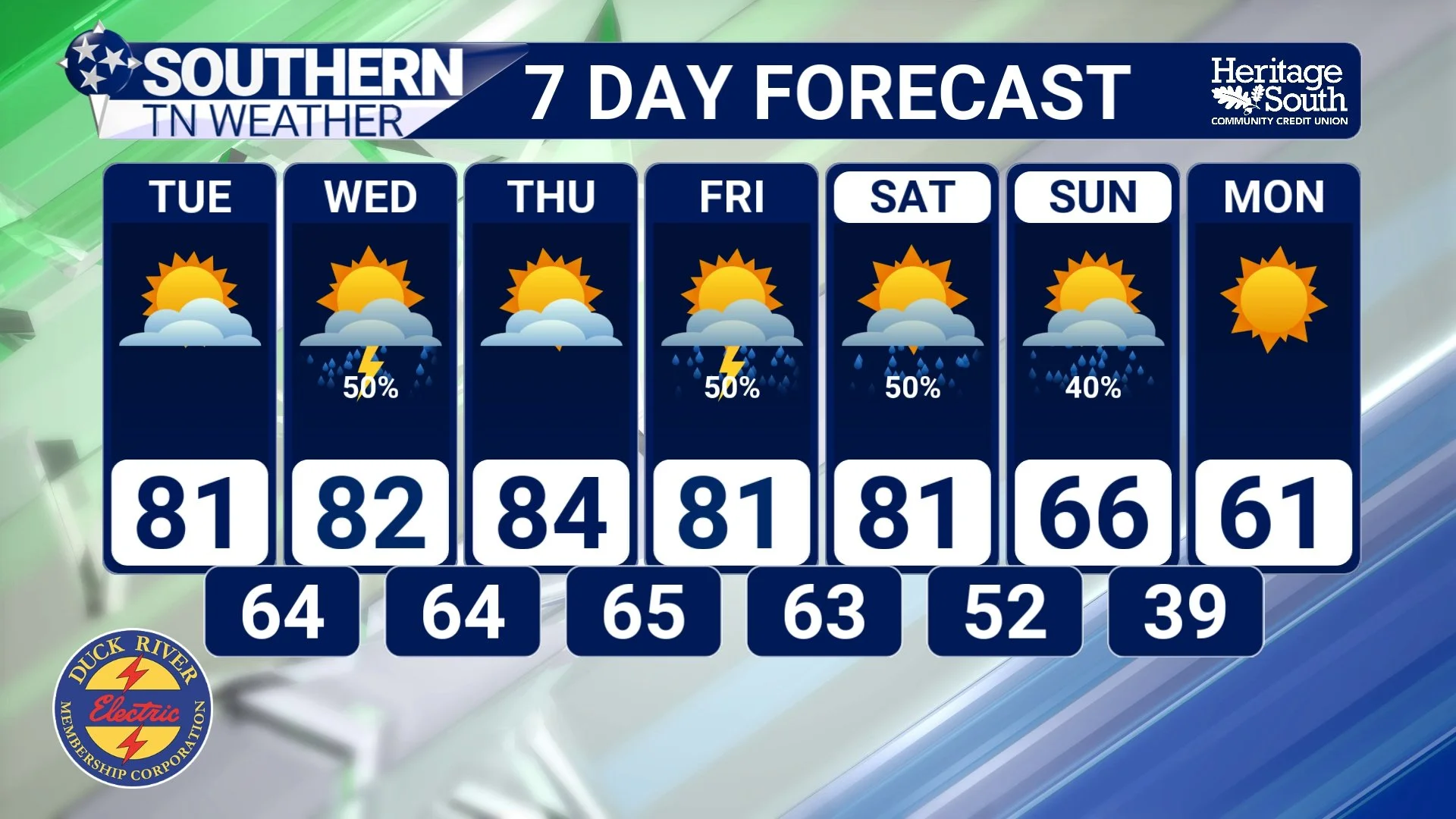
Starting Wednesday, we begin to see more of a diurnal pattern, where showers and storms develop primarily during the afternoon and early evening hours when daytime heating is maximized. By Thursday and Friday, as the broader system moves closer, rain chances become more widespread. These days likely bring the most consistent coverage of showers and thunderstorms. Another system may approach over the weekend, keeping rain chances in place into Sunday.
One notable aspect of this pattern is the high moisture content in the atmosphere. Precipitable water values are expected to be quite elevated for this time of year, which means that even weaker storms can produce efficient rainfall. Overall, total rainfall between Wednesday and Sunday is expected to range between 1 and 2 inches. While that won’t cause flooding issues, it will be beneficial rain, especially given the developing dry conditions we’ve been dealing with recently.
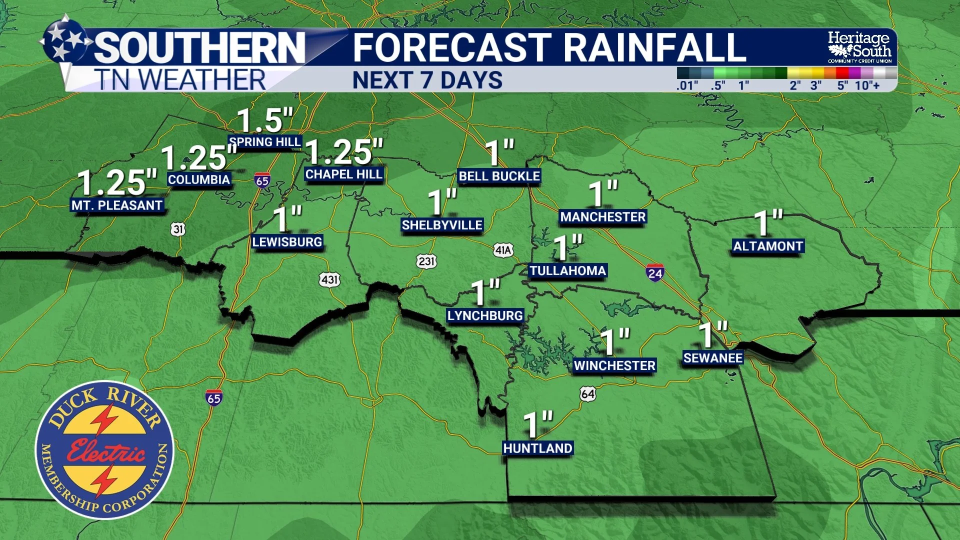
FORECAST RAINFALL - NEXT 7 DAYS
Warmth Sticks Around
Even with the increased cloud cover and rain chances, temperatures will remain well above normal. Highs will consistently reach into the 80s through much of the week, with Thursday likely being the warmest day. Even into the weekend, temperatures should hold near 80 degrees in many areas. This is because the overall air mass remains warm and moist, and there’s no strong push of cooler air behind these systems.
7-DAY FORECAST
The Bigger Picture
This upcoming pattern is a great example of how spring transitions work in the Southeast. We’re moving from a ridge-dominated, dry pattern into a more active setup driven by southwest flow aloft and repeated disturbances. It’s not a high-end severe weather pattern, but it is a productive rainfall pattern, which is something we’ve been lacking.
The Bottom Line 🧾
• Dry and warm conditions continue through Tuesday
• Rain chances return Wednesday and increase through the end of the week
• Storms will mainly be non-severe with limited instability
• Periods of rain could bring 1 to 3 inches total through Sunday
• Well above normal temperatures continue with highs in the 80s
• This will be beneficial rainfall for ongoing dry conditions
📰 Reminder: The Southern Tennessee Weather Blog, presented by Heritage South Community Credit Union, is updated Monday through Friday with fresh, locally tailored forecasts you can trust.