
Midweek Rain Returns, But an Overall Mild Week Is in Store

The Southern Tennessee Weather Blog is proudly presented by Heritage South Community Credit Union.
We Help When Others Won’t!
Visit https://www.heritagesouth.org/ today to see how HSCCU can help YOU!
A Cold Start to the Day
It was a downright cold start across Southern Middle Tennessee this morning... Several locations dipped into the low 10s, and a few colder, rural spots were in the single digits. This marks one of the colder mornings we’ve seen recently and serves as a reminder that winter still has a firm grip on our overnight temperatures. Despite the cold start, sunshine is doing its job today. With mostly clear skies and lighter winds, temperatures are rebounding nicely through the afternoon. Highs will climb into the 40s, which may not sound warm on paper, but after a morning like today, it will feel noticeably better.
Shelbyville also tied a record low temperature this morning, dropping to 9 degrees. The previous record for the date was set back in 1963, so this morning’s chill was no joke.
This setup is fairly typical for late fall and early winter. Clear skies and light winds overnight allow for strong radiational cooling, while daytime sunshine helps temperatures recover. The key takeaway is that while mornings are cold, we are not locking into a prolonged deep-freeze pattern at this time. That said, temperatures will once again fall into the 20s tonight, so another cold start is expected Tuesday morning.
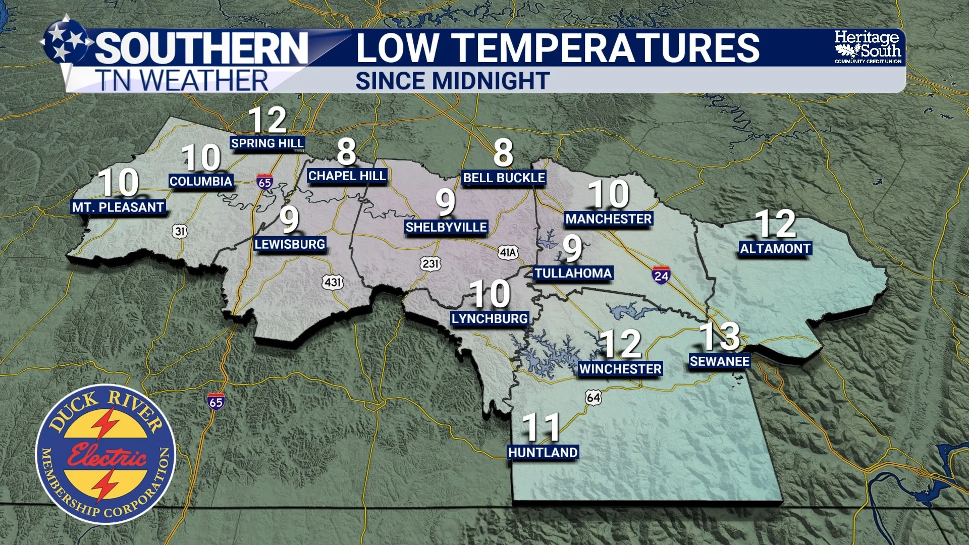
Low Temperatures This Morning
The Bigger Picture: A Mostly Mild Pattern With One Rainy Speed Bump
Looking at the overall pattern for the rest of the week, things remain fairly calm across the area. We stay under a generally zonal flow aloft, which favors near to slightly above-average temperatures for this time of year. Daytime highs will trend back toward the 50s for much of the region, with overnight lows settling into the 30s and low 40s.
While temperatures are manageable, the pattern does turn a bit more active late in the week. A developing warm front lifting north will help bring a round of showers into the area late Wednesday night into early Thursday. This will be followed by a cold front later Thursday into Thursday evening. This system looks fairly dynamic in terms of wind energy, but one key ingredient remains lacking. Instability, or storm fuel, continues to look very limited. Current ensemble guidance keeps the probability of meaningful surface-based instability quite low, which is why severe weather chances remain low at this time. In simple terms, the atmosphere may have the energy, but it won’t have enough fuel to fully take advantage of it.
Beneficial Rainfall, Not a Washout
What this setup does support is a solid chance for beneficial rainfall. Current projections suggest rainfall totals ranging between one-half inch and just under one inch across much of Southern Middle Tennessee. That’s enough to be noticeable, but not enough to raise flooding concerns. This rain will be especially welcome in parts of the area. Far southern portions of Marshall, Maury, and Bedford Counties are now classified as abnormally dry by the U.S. Drought Monitor. It may sound surprising after what has felt like a wet stretch, but recent rainfall events haven’t been particularly efficient at producing meaningful totals. This midweek system should help chip away at those deficits.
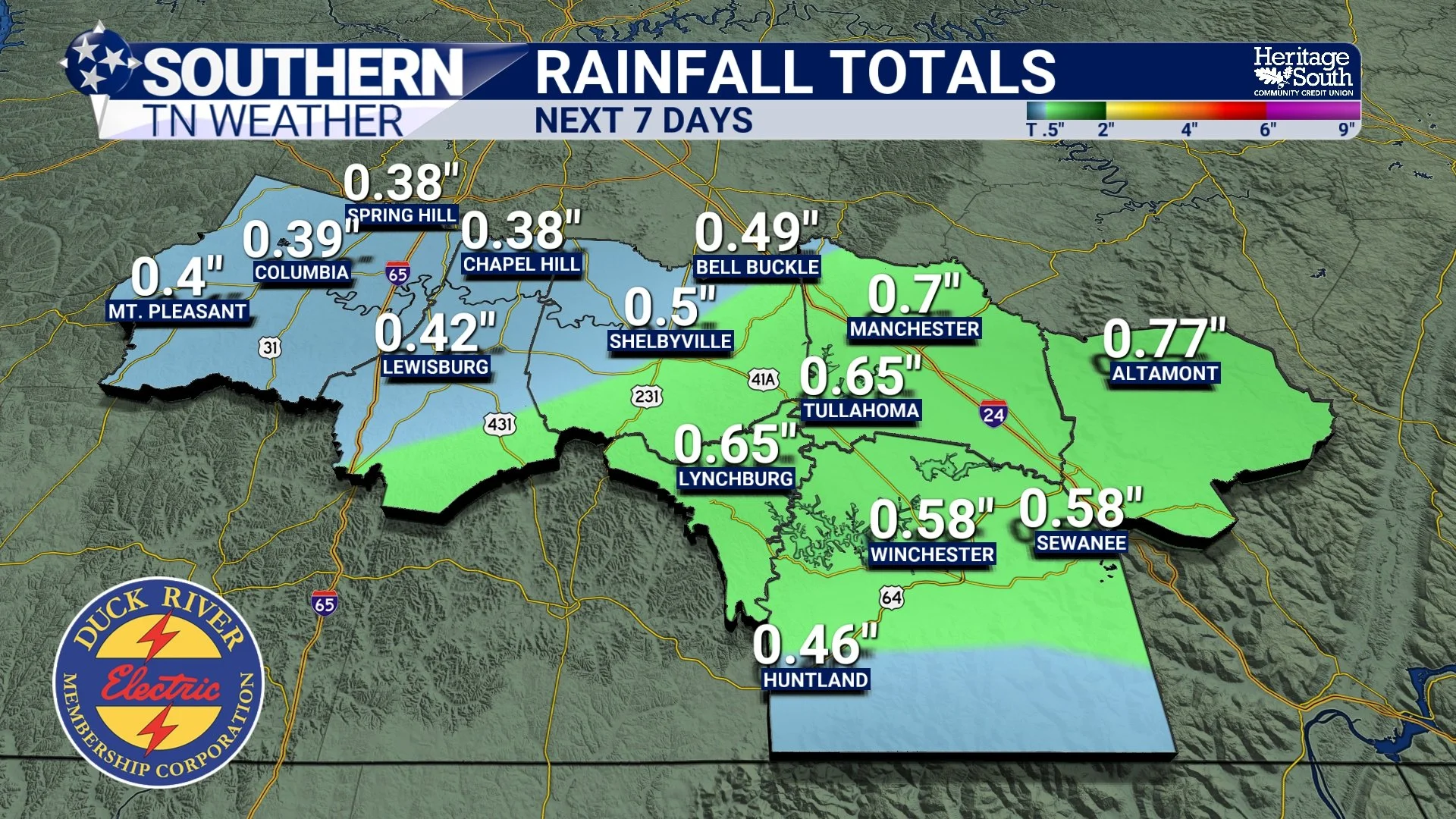
Forecast Rainfall Totals - Next 7 Days
Cooler Air Briefly Returns, Then a Quick Rebound
Behind the cold front late Thursday, temperatures will take a noticeable dip heading into Friday. Highs on Friday will struggle to get out of the 40s for many locations, which will feel like a step backward after the milder days earlier in the week.
The good news is that the cool-down doesn’t last long. As we head into the weekend, temperatures rebound quickly as zonal flow reestablishes itself. Saturday looks dry and seasonable, and while there are some low to medium rain chances showing up in the extended forecast for late weekend into early next week, timing and coverage remain uncertain. This is one of those patterns where small disturbances can appear several days out, only to shift or weaken as we get closer. For now, nothing looks overly concerning, and we’ll continue refining the details as the week goes on!
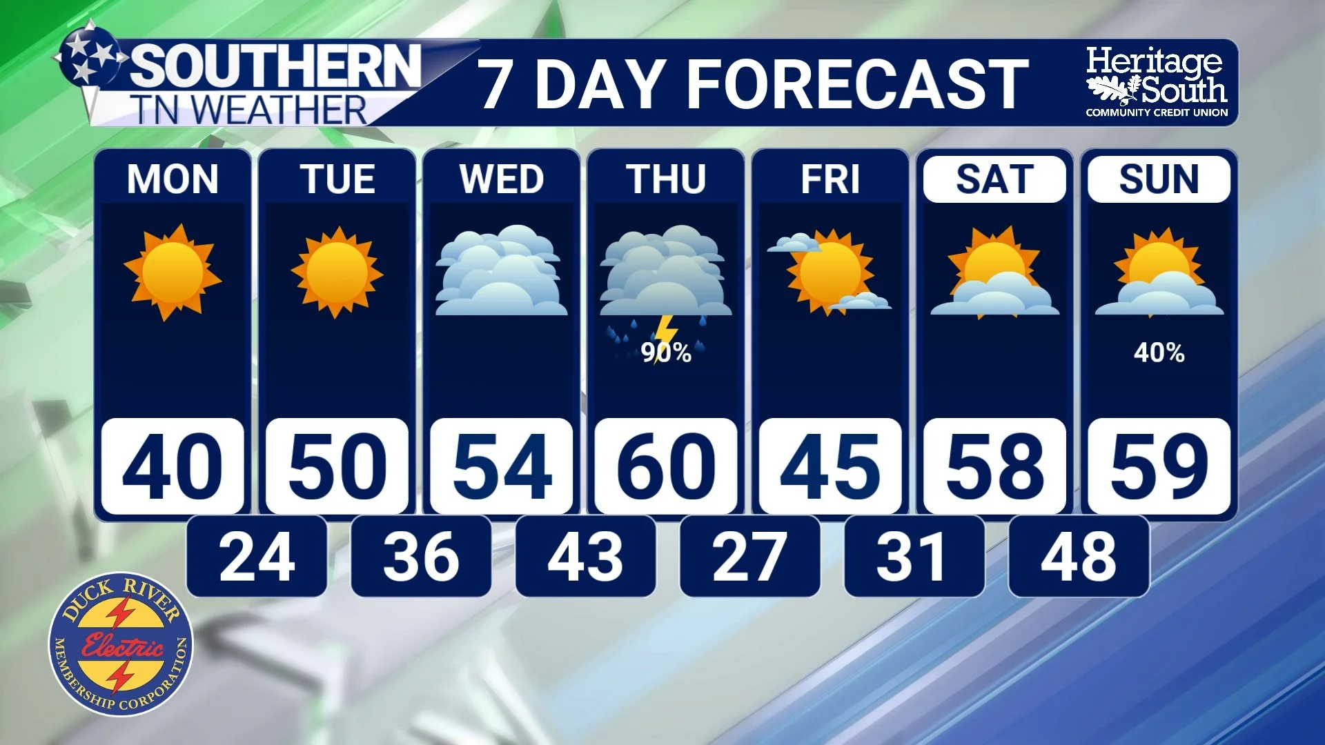
7 Day Forecast
The Bottom Line 🧾
• A cold start this morning with many locations in the 20s
• Sunshine helps temperatures rebound into the 40s and low 50s today
• A late-week system brings a good soaking rain, but severe weather chances remain low
• Rainfall totals generally between 0.50" and 0.90"
• Cooler air briefly arrives Friday before temperatures rebound for the weekend
📰 Reminder: The Southern Tennessee Weather Blog (Presented by Heritage South Community Credit Union) is updated Monday through Friday with fresh, locally tailored forecasts you can trust.