
Midweek Rain, Brief Snow Chances, Then a Dip Toward Winter

The Southern Tennessee Weather Blog is proudly presented by Heritage South Community Credit Union.
We Help When Others Won’t!
Visit https://www.heritagesouth.org/ today to see how HSCCU can help YOU!
Southern Middle Tennessee is entering a noticeably more active and colder weather pattern as we move through the middle of the week. After today’s mild conditions, rain returns Wednesday — followed by a sharp surge of cold air that may briefly flip rain to snow Wednesday evening, especially across the Cumberland Plateau.
This will not be a major winter storm for anyone in our area. However, light snow accumulations are becoming increasingly likely on the Plateau, and a prolonged stretch of colder-than-normal January weather will settle in behind this system.
This Afternoon & Tonight: Milder, but Changes Are Upstream
Gusty southwest winds are helping temperatures climb into the mid-50s to near 60° across Southern Middle Tennessee this afternoon. Skies are partly cloudy, and conditions remain dry.
Behind the scenes, however, a strong upper-level trough is diving southeast out of western Canada. This feature will dramatically amplify the pattern over the central and eastern U.S., setting the stage for rain Wednesday and a rapid temperature drop Wednesday evening.
Wednesday: Rain Develops, Then a Cold Front Moves In
Rain chances increase late tonight and especially Wednesday morning, spreading from northwest to southeast across the region. Periods of light rain are expected through the day Wednesday, with rainfall totals generally around 0.10" to 0.25" for most of Southern Middle Tennessee. The most likely window for rain is around sunrise through mid-afternoon. It will not rain continuously, but showers will be around on and off.
Temperatures may start in the 40s and lower 50s Wednesday, but will stall or slowly fall by afternoon as the cold front approaches. Winds will become gusty, then shift northwest behind the front late in the day.
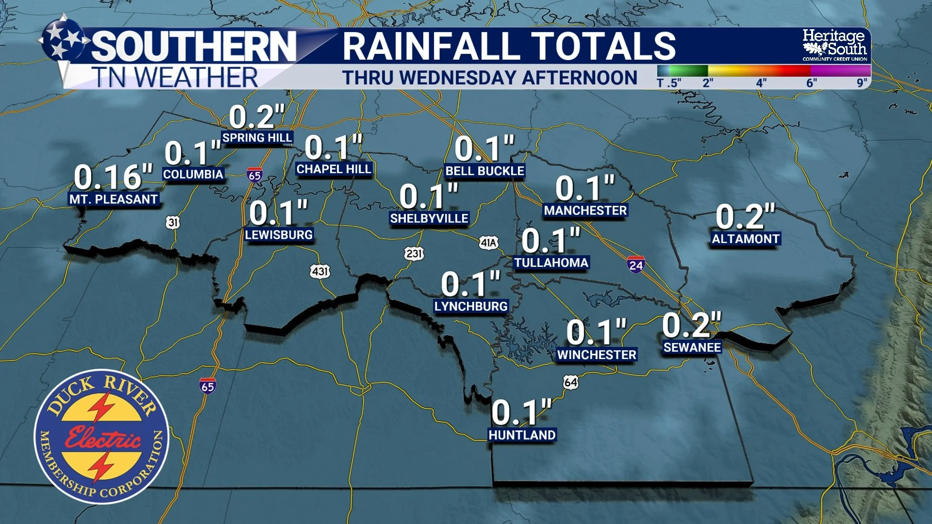
Rainfall Totals - Wednesday
Wednesday Evening: Rain Changes to Snow (Mainly the Plateau)
As the cold front pushes through Wednesday evening, much colder air will rush in quickly. As lingering moisture overlaps with falling temperatures, rain is expected to briefly change to snow or flurries, mainly from late afternoon through the evening hours. For most of Southern Middle Tennessee, this looks like a classic “cold chasing moisture” setup. That means snowflakes may fly, but the window is short and moisture is fading, which strongly limits accumulation potential. The Cumberland Plateau is the exception.
Don’t be surprised to see flakes flying tomorrow evening, especially after 4 PM through around midnight. For most communities west of the Plateau, no accumulation or impacts are expected. A brief dusting can’t be totally ruled out under a heavier shower, but overall, this is not a setup to get worked up over.
Current guidance supports:
• Light accumulating snow possible on the Plateau, with a dusting to under a half inch for areas like Altamont, Tracy City, and Coalmont
• Higher elevations having the best chance for minor accumulation
• Most of Southern Middle Tennessee seeing flakes with no accumulation
And yes… I talk about the Plateau a lot, and there’s a reason. The sharp elevation change creates a localized “microclimate.” Air is forced upward, clouds deepen more efficiently, and precipitation is more likely. This is why the Plateau can see snow when many surrounding areas see nothing at all.
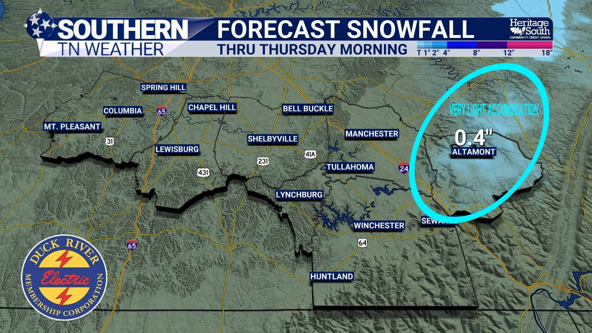
Snowfall Forecast - Thru Thursday Morning
Wednesday Night into Thursday Morning: Cold, Windy, A Few Slick Spots on the Plataeu
Snow ends Wednesday night as drier air moves in, but temperatures will plunge quickly into the teens and lower 20s by Thursday morning. Across the Plateau, a few slick spots are possible early Thursday where light snow falls and temperatures drop rapidly.
Northwest winds will increase, pushing wind chills into the single digits. These wind chills can be dangerous for those without adequate protection. Make sure to bundle up heading out Thursday morning.
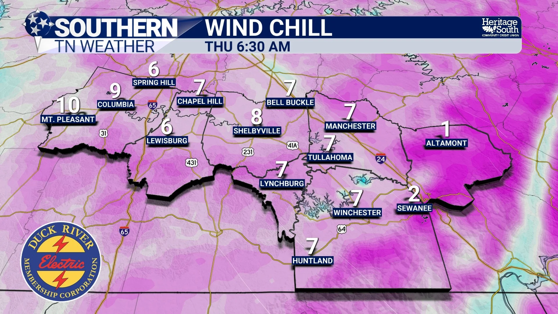
Wind Chill Forecast - Thursday Morning
Thursday Through the Weekend: Winter Takes Control
Behind this system, the pattern turns firmly wintry.
• Thursday: Blustery and cold. Highs mainly in the 30s
• Thursday night: Likely the coldest night of the stretch, upper teens to low 20s
• Friday: Dry, but cold. Highs in the 40s
• Weekend: Continued below-normal temperatures. A few weak disturbances may bring occasional flurries, but precipitation chances remain low
The bigger story late week into the weekend will be persistent cold, not the occasional flurries.
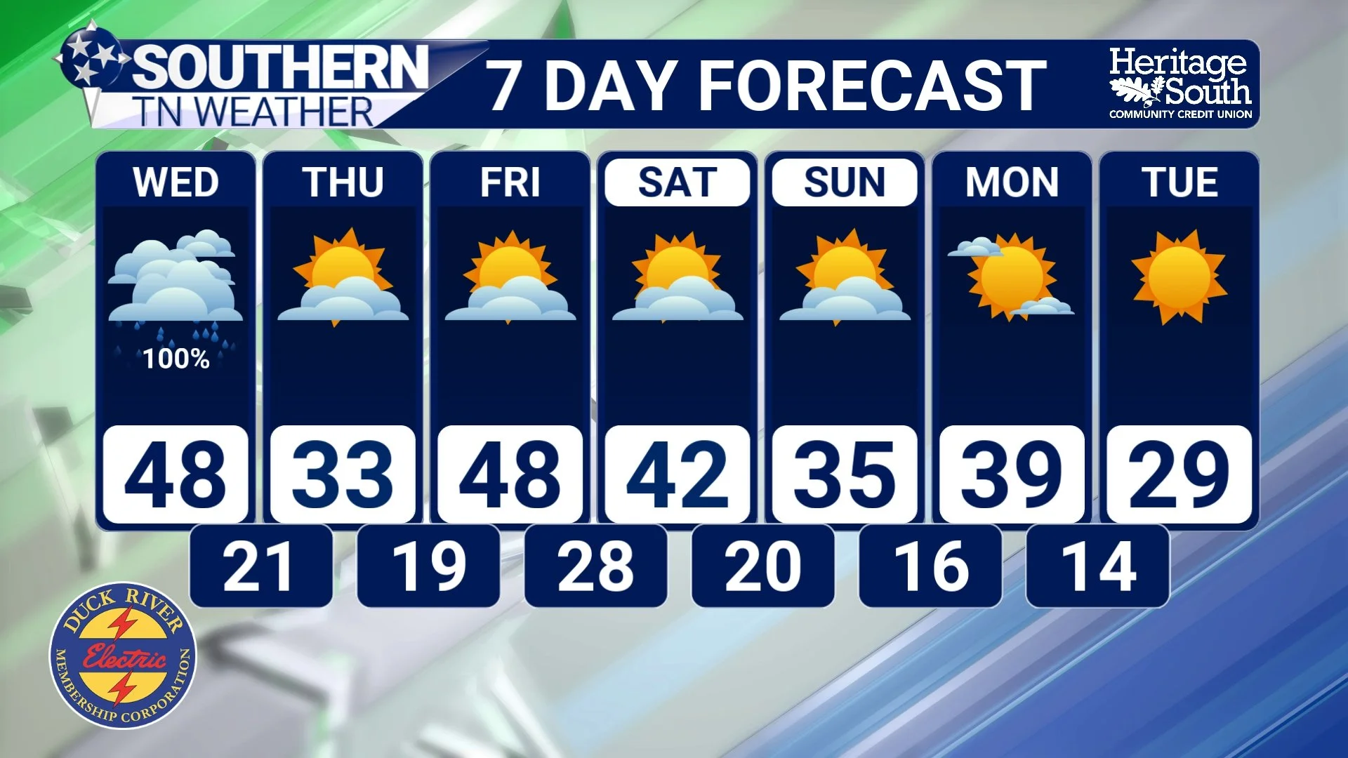
STNWX 7-Day Forecast
The Bottom Line 🧾
• Rain develops Wednesday as a strong cold front approaches
• Rain may briefly change to snow Wednesday evening
• Light accumulation is most likely on the Cumberland Plateau
• Most of Southern Middle Tennessee sees little to no accumulation
• Much colder air arrives Wednesday night
• A cold, January-style pattern settles in through the weekend
📰 Reminder: The Southern Tennessee Weather Blog (Presented by Heritage South Community Credit Union) is updated Monday through Friday with fresh, locally tailored forecasts you can trust.