
Gradual Warm-Up, With a Brief Shot at Rain Midweek

The Southern Tennessee Weather Blog is proudly presented by Heritage South Community Credit Union.
We Help When Others Won’t!
Visit https://www.heritagesouth.org/ today to see how HSCCU can help YOU!
Southern Middle Tennessee is coming out of a cold start to the week, but the quiet weather won’t last much longer. After a couple of dry days and a modest warm-up, our next system arrives Wednesday bringing rain — followed by a sharp temperature drop that may briefly flip rain to flurries Wednesday night into early Thursday, especially toward the Cumberland Plateau. This will not be a major winter storm for our area. At this time, any snow looks light, limited, and elevation-dependent. However, it does mark the beginning of a colder, more January-like pattern heading into the second half of the week.
Today Through Tuesday: Cold Mornings, Milder Afternoons
We started the day on a frosty note across Southern Middle Tennessee, with morning lows in the low 20s. High pressure is now firmly in control, providing abundant sunshine and light winds. That has allowed temperatures to rebound into the mid to upper 40s this afternoon. Tonight will once again be cold, with clear skies and light winds allowing temperatures to fall back into the upper 20s to near 30.
Tuesday continues the warming trend. Southerly flow develops, bringing highs into the 50s area-wide, with a few locations (especially along and west of I-65) possibly flirting with the low 60s. Clouds will gradually increase Tuesday night ahead of our next disturbance, keeping overnight lows much milder — mainly in the upper 30s to low 40s.
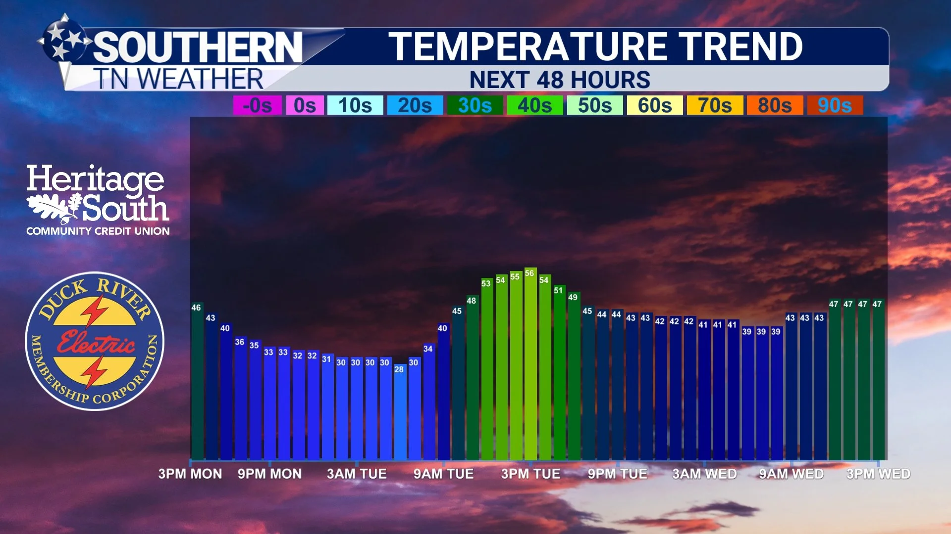
Temperature Trend - Next 48 Hours
Wednesday: Rain Returns, Then Colder Air Arrives
By Wednesday, the pattern becomes more active. An amplifying upper-level trough and a developing low over the Great Lakes will push a strong cold front toward the Tennessee Valley. Rain chances increase through the day, with scattered showers becoming more widespread in the morning and early afternoon. At this time, rainfall amounts look light to moderate, generally around a quarter inch or less for most of Southern Middle Tennessee.
Temperatures will likely start mild, then level off or slowly fall as clouds thicken and winds increase. Southwesterly winds ahead of the front may become gusty at times, then shift northwest behind the front late in the day.
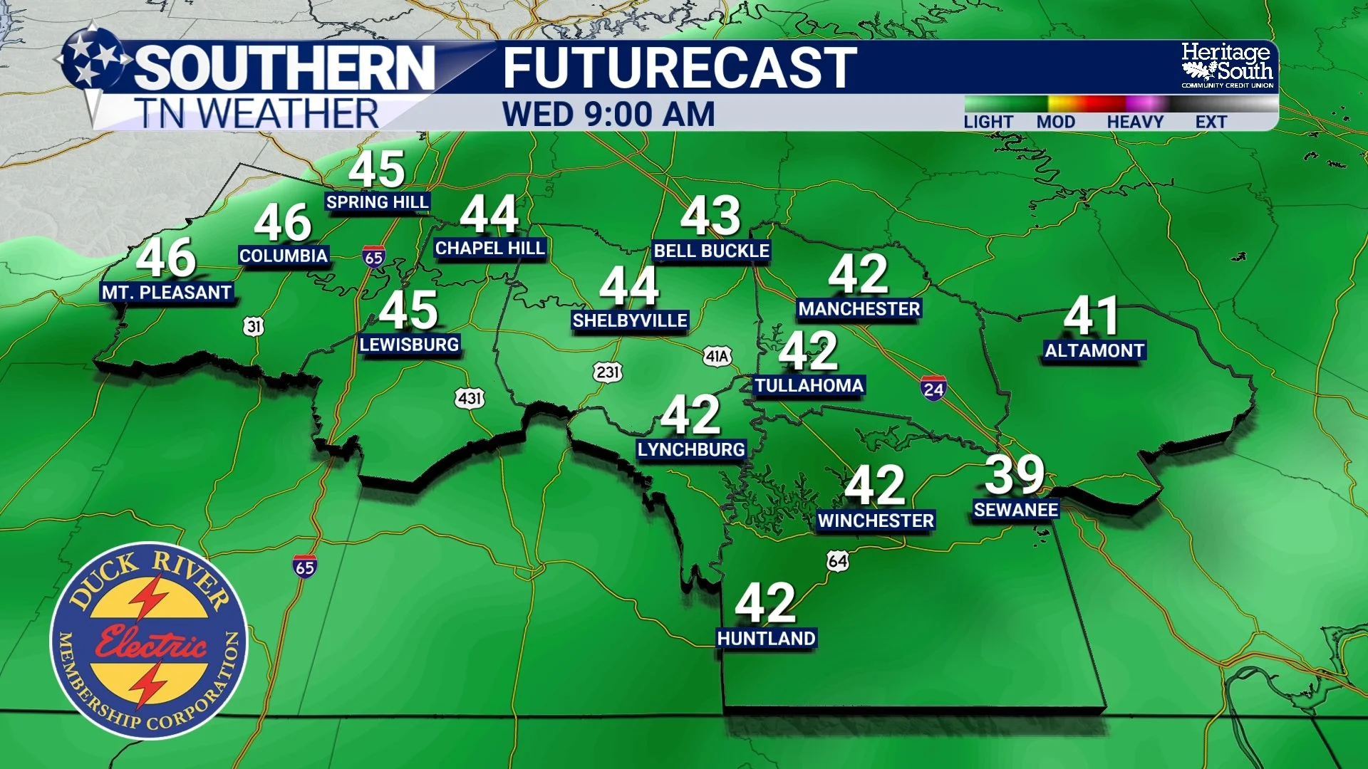
Futurecast - Wednesday AM
Wednesday Night into Early Thursday: Brief Rain-to-Snow Transition?
There has been quite a bit of social media buzz about a potential wintry system Wednesday night into Thursday morning. Let’s break this down scientifically. As the cold front moves through Wednesday night, much colder air will rush into the region. As lingering moisture overlaps with this colder air, rain may briefly mix with or change to snow, especially late Wednesday night into early Thursday.
Right now, guidance continues to trend lower with snow potential:
• Best chance for flakes: Cumberland Plateau
• Plateau snow probabilities: ~0–10% for 1", ~30% for a half-inch
• West of the Plateau: measurable snow appears unlikely
Any snow that does occur should be light and short-lived. Ground temperatures remain relatively warm, and precipitation will be weakening as colder air arrives. At this time, no significant travel impacts are anticipated.
Now for the “why.” Systems like this (where cold air chases moisture) are not our classic Middle Tennessee snow producers. Locally, our bigger winter events usually come from Gulf lows: storm systems that develop along the Texas/Louisiana Gulf Coast and track northeast. Those systems bring deep moisture northward while cold air is already in place. Think February 2021. Think January 2022. Gulf lows… This midweek setup is more of a frontal passage than a true winter storm, which is why snow chances remain limited. Am I saying no to a flurry or quick snow shower across the entire area? Absolutely not. But let’s not pretend this is going to be a good snow.
Don’t fret though! Climatologically, our better snow opportunities usually come in February and even March. There’s still plenty of winter left!
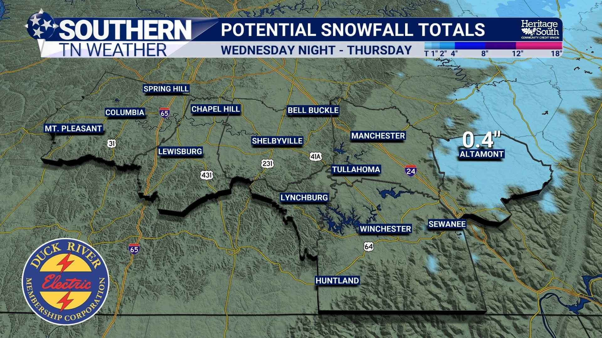
Potential Snowfall Totals - Wednesday Night into Thursday
Thursday into the Weekend: Turning Colder and More Seasonal
Behind this system, winter finally reasserts itself. Thursday will be a raw, blustery day. Highs will struggle to climb out of the 30s, and northwest winds will make it feel colder. Thursday morning, wind chill values could be in the single digits… By Thursday night, skies clear and winds relax, allowing temperatures to drop into the teens and lower 20s.
Friday looks dry but cold, with highs in the 40s. Additional disturbances may brush the region this weekend, but precipitation chances remain low at this time. The bigger story will be the cold, with below-normal temperatures continuing into next week. The latest 6 to 10 day temperature Outlook from the Climate Prediction Center has our area squarely in the Below Average Temperature Category for January 18th through the 22nd.
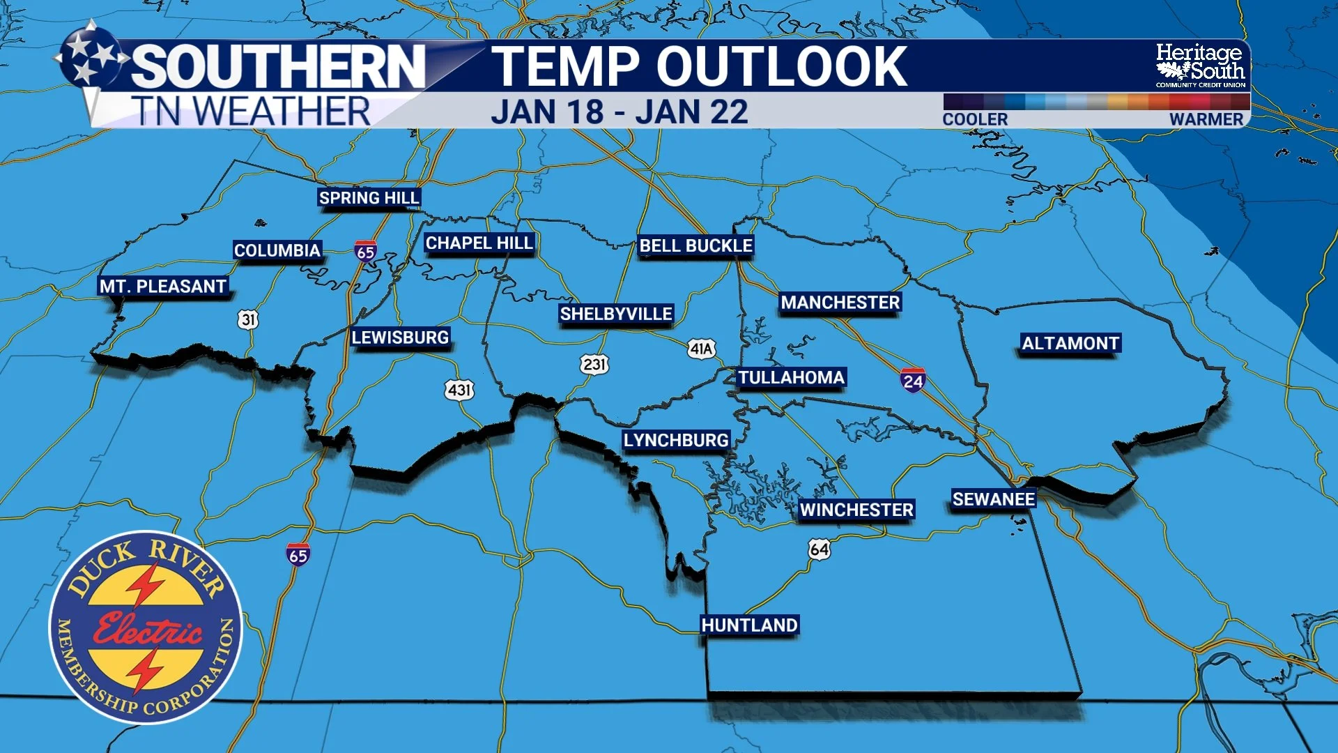
CPC Temperature Outlook
The Bottom Line 🧾
• Cold mornings and a gradual warm-up today and Tuesday
• Rain returns Wednesday as a strong cold front approaches
• A brief rain-to-snow changeover is possible Wednesday night, mainly near the Plateau
• Little to no accumulation expected for most of Southern Middle Tennessee, outside of maybe a quick dusting in Grundy County on the Plateau
• Colder, more seasonable January weather settles in Thursday through the weekend
📰 Reminder: The Southern Tennessee Weather Blog (Presented by Heritage South Community Credit Union) is updated Monday through Friday with fresh, locally tailored forecasts you can trust.