
Low-End Severe Storm Risk This Afternoon & Evening

The Southern Tennessee Weather Blog is proudly presented by Heritage South Community Credit Union.
We Help When Others Won’t!
Visit https://www.heritagesouth.org/ today to see how HSCCU can help YOU!
After several days of talking almost exclusively about the dangerous heat, today finally gives us something else to watch. The Storm Prediction Center has upgraded southern portions of our coverage area to a SLIGHT RISK (Level 2 of 5) for severe thunderstorms this afternoon and evening, while the remainder of Southern Middle Tennessee remains under a MARGINAL RISK (Level 1 of 5). This is not a widespread, high-end severe weather setup like we often see during the spring. Instead, this is a classic summertime pattern where only a few storms become severe—but the ones that do can become intense in a hurry.
The biggest challenge today is that not everyone will see rain. In fact, many communities will stay completely dry. However, if a thunderstorm develops over your neighborhood, it could quickly produce damaging wind gusts before collapsing.
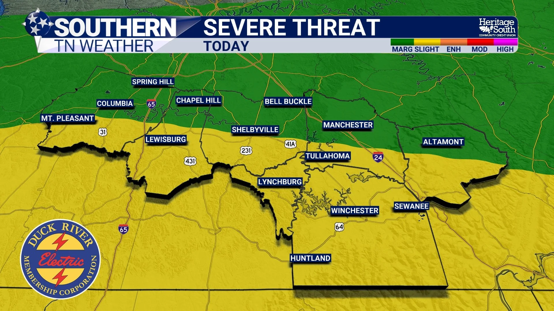
SEVERE THREAT - TODAY
The Heat Is Fueling Today's Storms
The same weather pattern that's producing dangerous heat is also creating an atmosphere loaded with energy. Temperatures this afternoon will climb into the middle and upper 90s while dewpoints remain in the middle 70s. That combination will once again push heat index values into the 105° to 110° range while creating an extremely unstable atmosphere.
We measure instability using a value called CAPE, and today those values are expected to exceed 3,000 to 4,000 J/kg across parts of the region. Simply put, the atmosphere will have plenty of fuel available for thunderstorms. The missing ingredient is widespread forcing. Without a strong cold front moving through the area, storms won't develop everywhere. Instead, they'll rely on smaller-scale boundaries and daytime heating to get started.
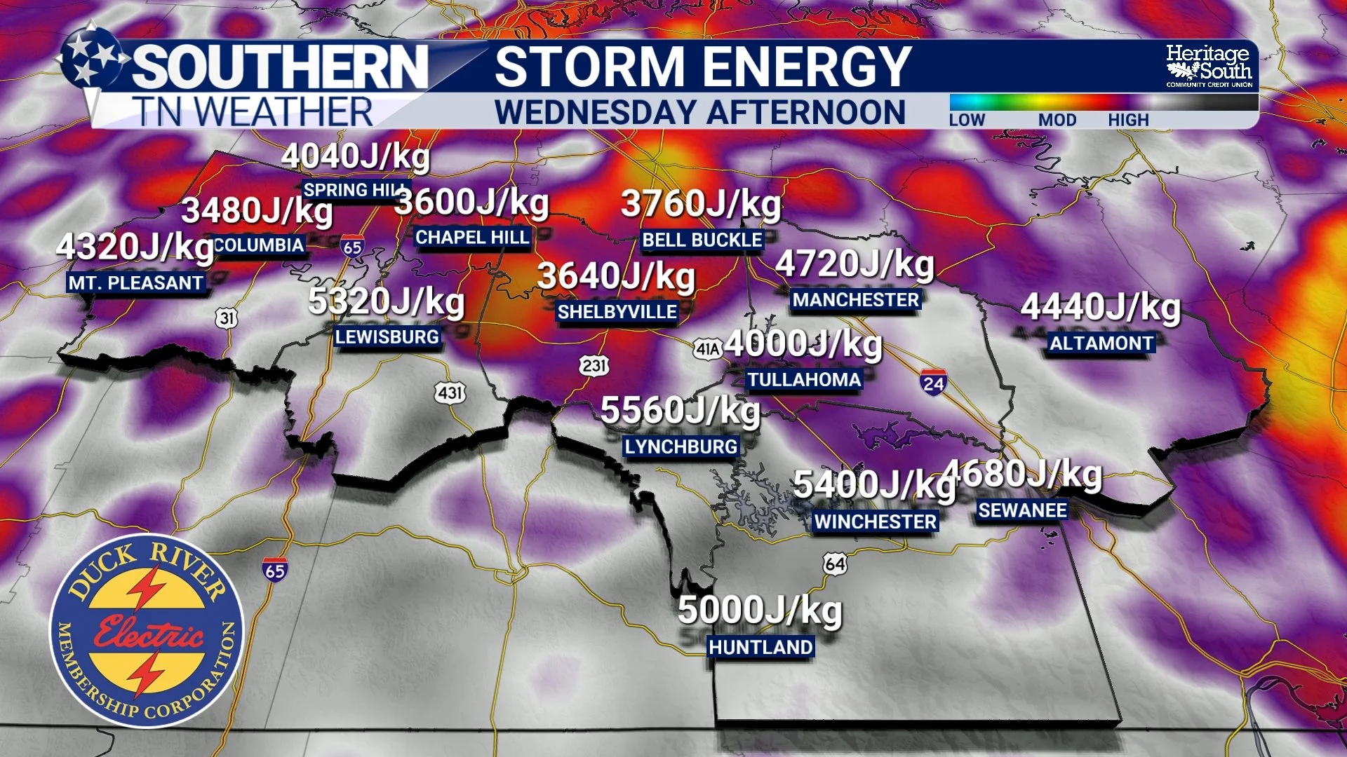
STORM ENERGY - WEDNESDAY
Why The Severe Threat Remains Relatively Low
One question I've already received today is, "If there's so much instability, why isn't the risk higher?" The answer comes down to storm coverage.
Today's setup favors scattered, pulse-type thunderstorms rather than a long line of organized severe storms. Most communities won't see much, if any, rainfall. However, the storms that do develop will have access to tremendous instability and can briefly become quite strong before weakening. That's why most of our area remains in a Marginal Risk, with southern portions upgraded to a Slight Risk where confidence is a bit higher that scattered severe storms will develop. Even there, this is still expected to be an isolated severe weather event rather than a widespread outbreak.
Damaging Wind Is The Primary Concern
Today's greatest concern is localized damaging downburst winds. Unlike tornadoes, which rotate, downbursts occur when rain-cooled air rushes toward the ground before spreading outward in all directions. With the amount of moisture and instability in place today, some thunderstorms may produce powerful wet microbursts capable of knocking down trees, producing scattered power outages, and causing localized damage.
The strongest storms could produce wind gusts between 50 and 65 MPH. Frequent lightning and torrential rainfall will accompany any storm as well. Because these storms will move rather slowly, rainfall rates could become very heavy in a short amount of time, although widespread flooding is not expected. A very isolated instance of small hail can't be ruled out either, but damaging winds remain the primary concern.
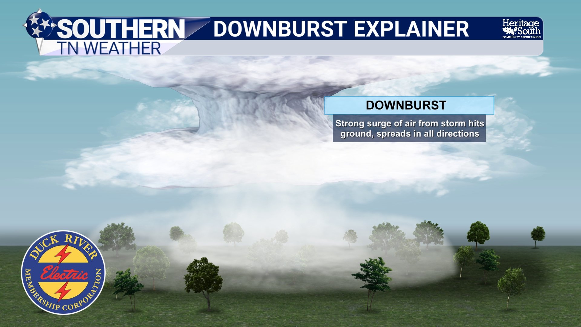
DOWNBURST EXPLAINER
Timing
Storm development should gradually increase through the afternoon as daytime heating reaches its peak. The best opportunity for stronger storms appears to be between 1 PM and 8 PM, with activity becoming more isolated and gradually fading after sunset as the atmosphere begins to cool.
A Severe Thunderstorm Watch is currently in effect through 8 PM for Franklin, Lincoln, and Moore counties, where confidence is highest that scattered severe storms could develop first. Additional counties could be added later if storms become more widespread than currently expected, but right now that looks unlikely.
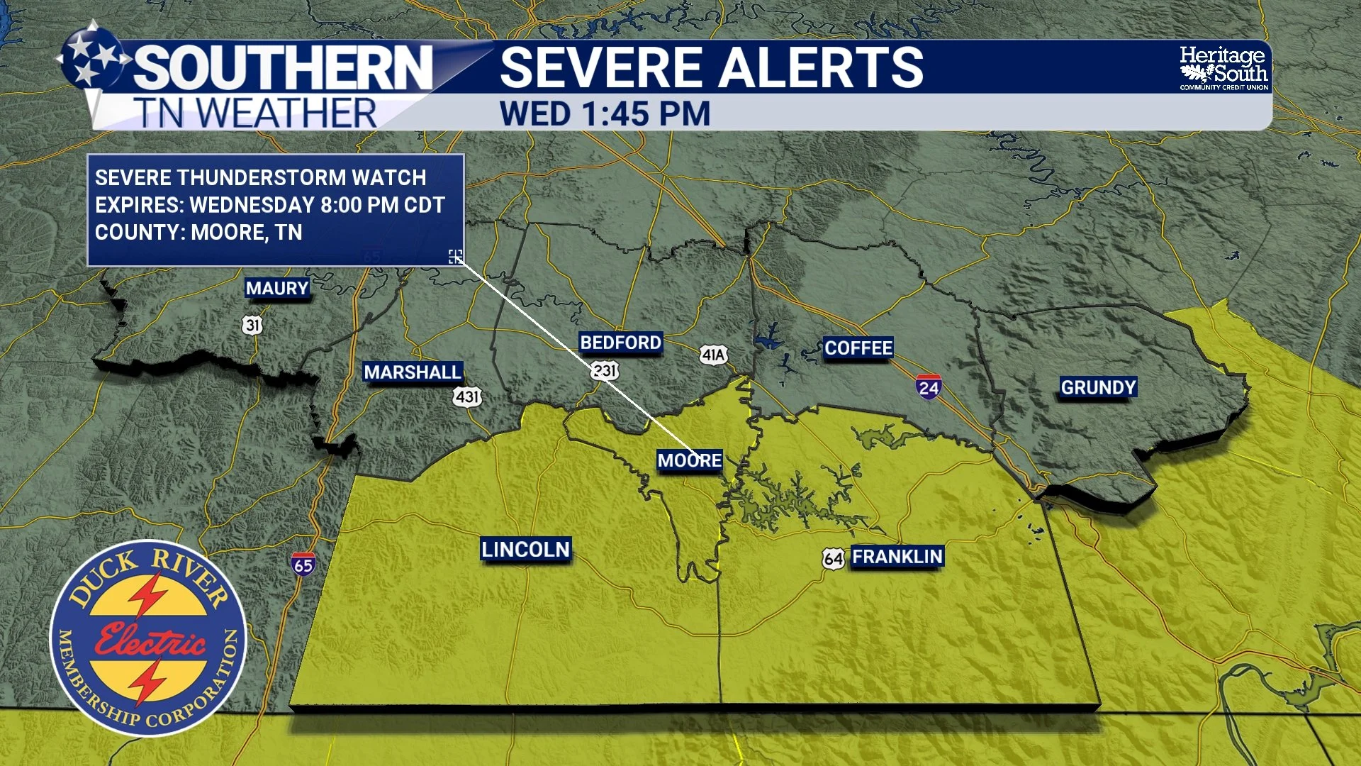
SEVERE ALERTS - THIS AFTERNOON
Looking Ahead
The dangerous heat isn't going anywhere just yet. An Extreme Heat Warning remains in effect through Friday for much of Southern Middle Tennessee, with heat index values once again climbing above 105 degrees each afternoon. Rain chances become a bit lower Thursday and Friday, although isolated afternoon thunderstorms remain possible. Looking ahead to the Independence Day weekend, scattered afternoon and evening thunderstorms continue to look possible each day, but we're not expecting an all-day washout.
I'll continue watching radar trends closely throughout the afternoon and will provide updates if storms begin organizing or additional watches are issued.
The Bottom Line 🧾
Southern portions of the area have been upgraded to a SLIGHT RISK (Level 2 of 5) for severe thunderstorms, with the remainder under a MARGINAL RISK (Level 1 of 5).
Not everyone will see rain, but any storm that develops could become strong quickly.
Damaging wind gusts of 50 to 65 MPH are the primary concern.
Heavy rainfall, frequent lightning, and an isolated report of small hail are also possible.
The greatest chance for storms is between 1 PM and 8 PM.
A Severe Thunderstorm Watch remains in effect until 8 PM for Franklin, Lincoln, and Moore counties.
An Extreme Heat Warning continues with heat index values between 105° and 110°.
I'll have updates throughout the afternoon as storms begin to develop.
📰 Reminder: The Southern Tennessee Weather Blog, presented by Heritage South Community Credit Union, is updated Monday through Friday with fresh, locally tailored forecasts you can trust.