
Drought Improving, But Heat & Storms Continue Into The Holiday Weekend

The Southern Tennessee Weather Blog is proudly presented by Heritage South Community Credit Union.
We Help When Others Won’t!
Visit https://www.heritagesouth.org/ today to see how HSCCU can help YOU!
We've spent the past week talking almost exclusively about dangerous heat, heat indices over 110 degrees, and the daily chance for a few strong afternoon thunderstorms. Those remain the primary weather stories through the Independence Day weekend. But today, I wanted to highlight something we don't get to talk about very often. For many of us, the drought is officially over!
After months of below-normal rainfall earlier this year, repeated rounds of soaking rain throughout June have dramatically improved conditions across Southern Middle Tennessee. While not every community has received the same amount of rain, many areas have picked up well above normal precipitation over the past several weeks. That has allowed streams to recover, ponds to refill, lawns to green back up, and soils to regain much-needed moisture. In fact, the latest U.S. Drought Monitor shows drought conditions have been eliminated across portions of our area, with additional improvements elsewhere. It's welcome news after spending much of the spring watching drought conditions steadily expand.
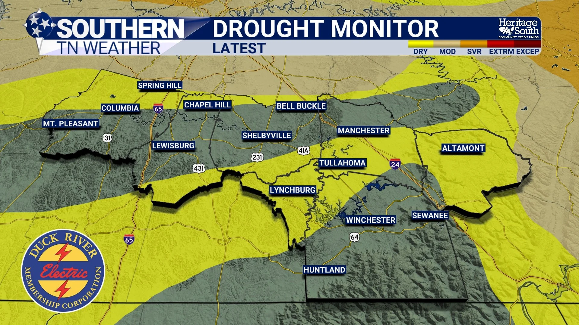
DROUGHT MONITOR - LATEST
The Heat Isn't Finished Yet
Unfortunately, one thing that hasn't changed is the heat. An Extreme Heat Warning remains in effect through Friday for much of Southern Middle Tennessee. Afternoon temperatures will once again climb into the middle and upper 90s, while heat index values soar between 105° and 110°. Perhaps the biggest issue continues to be the warm nights. Overnight lows are only falling into the middle and upper 70s, offering very little opportunity for homes, roads, and even our bodies to cool off before the next day begins.
If you're spending time outdoors over the holiday weekend, continue taking frequent breaks, stay hydrated, and don't underestimate how dangerous several consecutive days of extreme heat can become.
Another Round Of Strong Storms Today
The Storm Prediction Center has placed all of Southern Middle Tennessee under a SLIGHT RISK (Level 2 of 5) for severe thunderstorms this afternoon and evening. Just like yesterday, this is expected to be a conditional severe weather setup. In other words, not everyone will see storms. However, those that do could experience a quick burst of severe weather.
The atmosphere is once again extremely unstable, with enough energy to support scattered thunderstorms capable of producing damaging downburst winds, torrential rainfall, frequent lightning, and perhaps some small hail. The strongest storms are expected between 2 PM and 8 PM before quickly fading after sunset. Localized flash flooding is also possible where storms repeatedly move over the same locations, with rainfall rates occasionally exceeding one inch per hour.
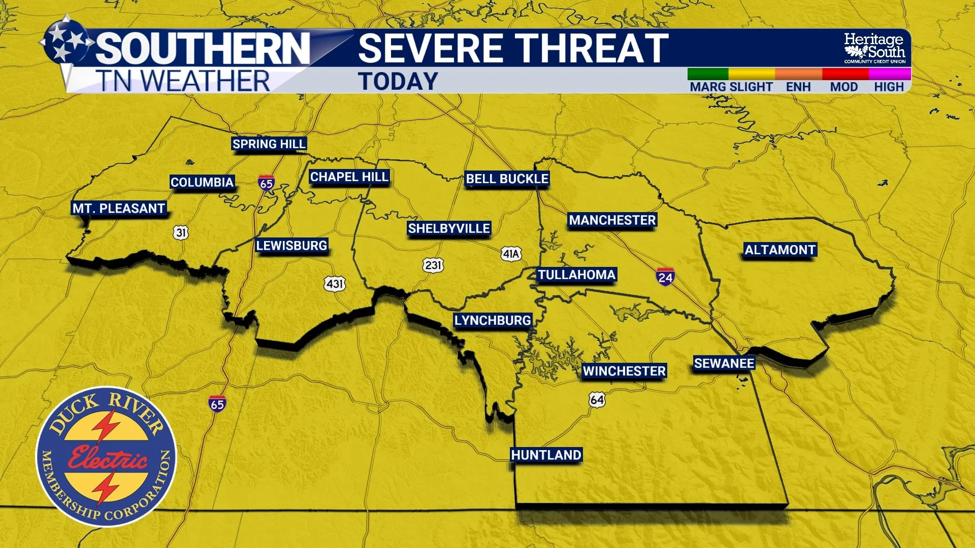
SEVERE THREAT - TODAY
Looking Ahead To The Holiday Weekend
Friday brings another hot and humid day with scattered afternoon thunderstorms. The overall severe weather threat looks a bit lower than today, although a few stronger storms with gusty winds and heavy downpours can't be ruled out. A MARGINAL risk (level 1/5) is in place for severe thunderstorms. Independence Day continues to look fairly typical for early July.
It will still be hot, although temperatures may ease down just a couple of degrees as the upper-level ridge slowly weakens. Isolated to scattered afternoon and evening thunderstorms will remain possible, which means outdoor plans and fireworks displays could briefly be interrupted in a few locations. That said, we're not expecting an all-day washout, and many communities should remain dry for much of the day.
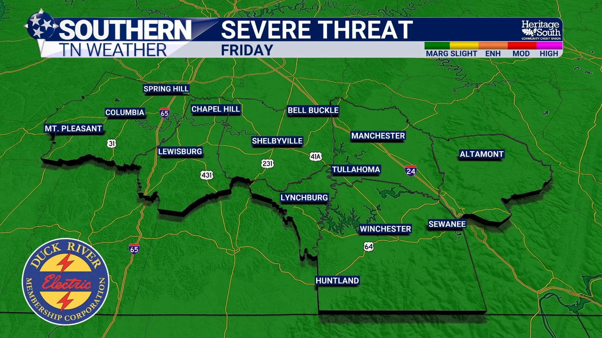
SEVERE THREAT - FRIDAY
Better News Next Week
The weather pattern finally begins changing as we head into next week. The upper-level ridge responsible for this prolonged heat wave will continue weakening and shifting eastward, allowing temperatures to settle back closer to normal for early July. Highs should return to the lower 90s instead of the upper 90s, and while it'll still feel like summer, it won't be quite as oppressive.
We'll also transition into a more typical summertime pattern with daily afternoon shower and thunderstorm chances around 40 to 50 percent. Most of these storms will be driven by daytime heating, meaning they'll be scattered in nature rather than widespread. At this point, there are no strong indications of organized severe weather next week, although any storm could still produce gusty winds and heavy rainfall.
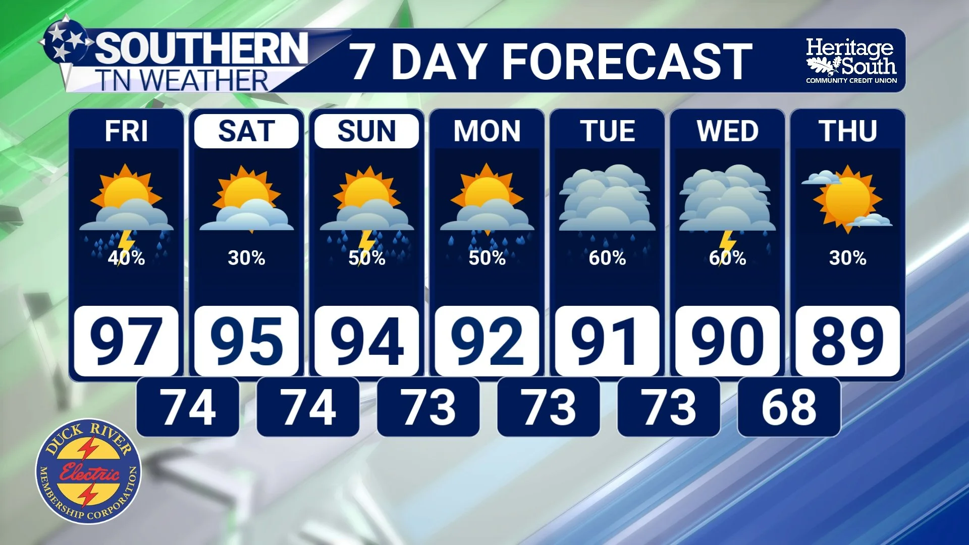
7-DAY FORECAST
The Bottom Line 🧾
The latest U.S. Drought Monitor shows significant improvement, with drought eliminated across portions of Southern Middle Tennessee.
An Extreme Heat Warning remains in effect through Friday.
Heat index values will once again climb between 105° and 110° this afternoon.
A SLIGHT RISK (Level 2 of 5) for severe thunderstorms remains in effect today, with damaging wind gusts as the primary concern.
Scattered afternoon storms remain possible Friday and on the Fourth of July, but we're not expecting an all-day washout.
Next week brings temperatures closer to seasonal normals along with more typical summertime afternoon shower and thunderstorm chances.
📰 Reminder: The Southern Tennessee Weather Blog, presented by Heritage South Community Credit Union, is updated Monday through Friday with fresh, locally tailored forecasts you can trust.