
Independence Day: In-Depth Forecast Here

The Southern Tennessee Weather Blog is proudly presented by Heritage South Community Credit Union.
We Help When Others Won’t!
Visit https://www.heritagesouth.org/ today to see how HSCCU can help YOU!
Happy Birthday, America! The Fourth of July is finally here, and after one of the hottest stretches we've experienced in several years, I have some encouraging news. While the heat certainly isn't going away, we're finally beginning to see the weather pattern change ever so slightly. Temperatures will ease down a couple of degrees, and while scattered thunderstorms remain in the forecast, this does not look like an all-day washout.
That said, there are still a few weather concerns you'll want to keep in mind before heading out to parades, cookouts, the lake, or your favorite fireworks show.
The Heat Isn't Over Yet
Even though our prolonged heat wave is beginning to weaken, Saturday will still be another hot and humid day across Southern Middle Tennessee. High temperatures will climb into the lower and middle 90s during the afternoon. Add in Tennessee's trademark humidity, and it'll feel more like 100° to 105° during the hottest part of the day. A Heat Advisory remains in effect through Saturday evening, so if you're planning to spend several hours outside, continue taking the heat seriously. Drink plenty of water, wear light-colored clothing, and don't wait until you feel thirsty before hydrating.
The good news is that this should be one of the last days of the more oppressive heat. By next week, temperatures settle much closer to what's considered normal for early July.
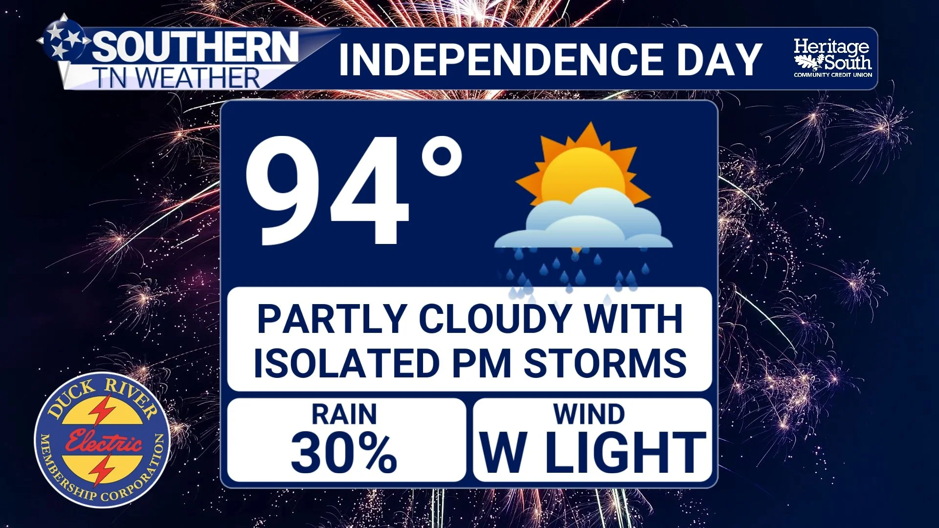
INDEPENDENCE DAY - FORECAST
Afternoon Storms Will Be Hit-or-Miss
The biggest forecast question continues to be thunderstorm coverage Saturday afternoon and evening. As the upper-level ridge weakens and shifts eastward, scattered showers and thunderstorms will once again develop during the heat of the day. Unlike a cold front that brings widespread rain to everyone, these will be the typical summertime "pop-up" thunderstorms.
That means many communities may stay completely dry all day, while others could experience a quick downpour just a few miles away. If you've lived in Tennessee very long, you've probably experienced this before. The atmosphere won't be quite as unstable as it has been the past couple of afternoons, so the overall severe weather threat has decreased. At this time, no organized severe weather outlook is in place for Independence Day. Still, any stronger storm could produce gusty winds, torrential rainfall, frequent lightning, and brief heavy downpours before quickly weakening.
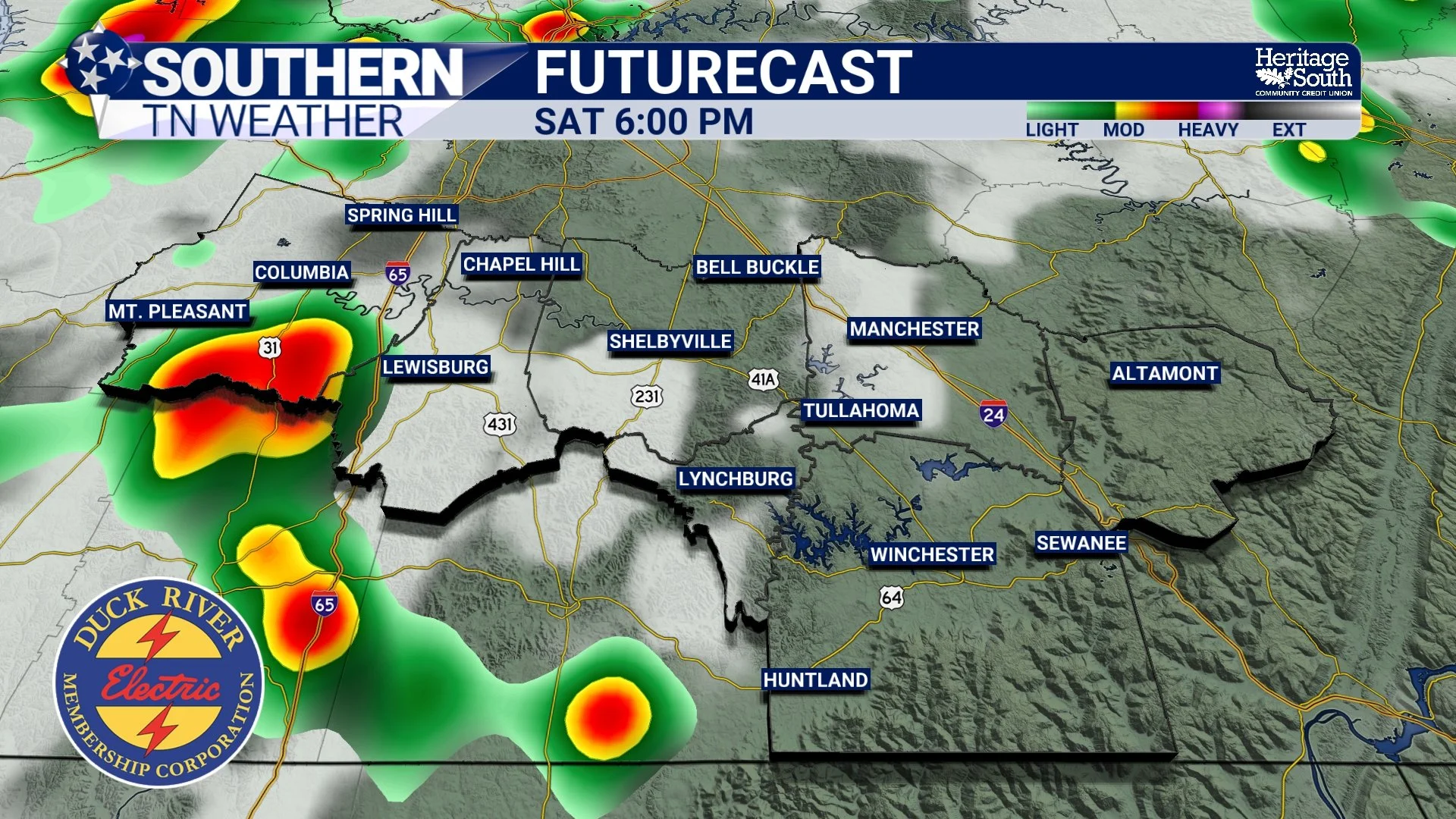
FUTURECAST - SATURDAY EVENING
Will Fireworks Be Affected?
This is, without question, the most common question I've received over the past 24 hours. The answer is... possibly, but not everywhere.
Most of the thunderstorm activity should develop during the afternoon and early evening hours. Forecast guidance suggests storms may linger a little longer than we've seen the past few days, which does introduce some uncertainty for fireworks displays. The good news is that thunderstorm coverage should gradually decrease after sunset. That doesn't guarantee every fireworks show stays completely dry, but it does improve the odds as the evening goes on.
If you have plans Saturday night, I wouldn't cancel them. Instead, I'd simply check the radar before heading out. There's a good chance your event never sees a drop of rain, but if a thunderstorm happens to develop nearby, it may require a brief delay. And make sure you have the best radar of them all… stnweather.com/apps
Looking Ahead
The weather pattern becomes much more typical for early July beginning Sunday and continuing through next week. The intense upper-level ridge responsible for this week's dangerous heat continues to weaken, allowing temperatures to settle back into the upper 80s and lower 90s. At the same time, daily afternoon shower and thunderstorm chances increase into the 40 to 60 percent range.
That doesn't mean it'll rain all day every day. Instead, expect the familiar summertime routine of sunshine during the morning, scattered thunderstorms during the afternoon, and quieter conditions after sunset. While organized severe weather isn't expected, a few stronger storms could still produce gusty winds and locally heavy rainfall. Overall, next week's forecast looks much more typical for July than what we've experienced recently.
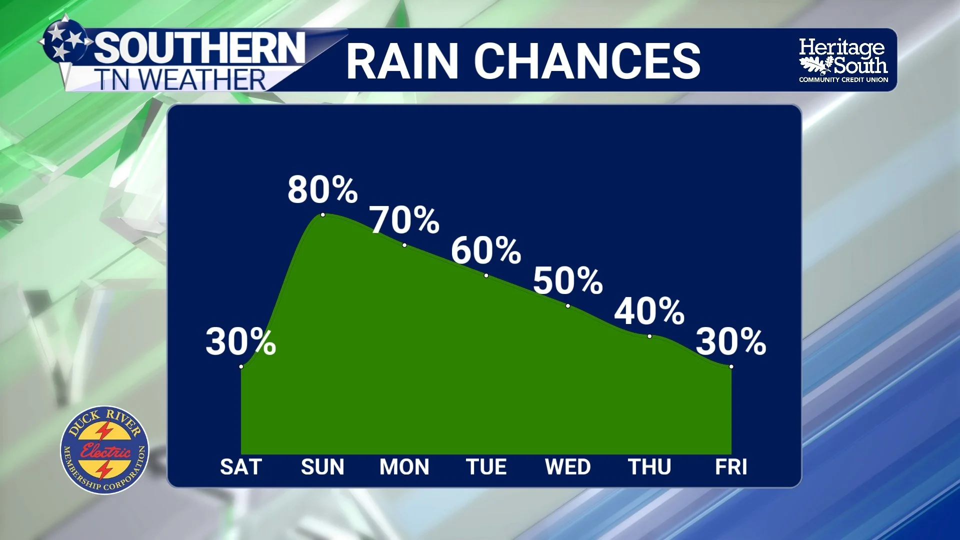
RAIN CHANCES - NEXT 7 DAYS
The Bottom Line 🧾
Happy Independence Day!
Highs Saturday reach the lower to middle 90s with heat index values between 100° and 105°.
A Heat Advisory remains in effect through Saturday evening.
Scattered afternoon and early evening thunderstorms are expected.
Widespread severe weather is not expected, but a few storms could produce gusty winds, lightning, and heavy rainfall.
Fireworks should be able to proceed in most locations, but keep an eye on the radar for isolated storms.
Next week brings temperatures closer to seasonal normals along with more typical afternoon shower and thunderstorm chances.
📰 Reminder: The Southern Tennessee Weather Blog, presented by Heritage South Community Credit Union, is updated Monday through Friday with fresh, locally tailored forecasts you can trust.