
A More Typical Summer Pattern Settles In

The Southern Tennessee Weather Blog is proudly presented by Heritage South Community Credit Union.
We Help When Others Won’t!
Visit https://www.heritagesouth.org/ today to see how HSCCU can help YOU!
After the prolonged stretch of dangerous heat last week, Southern Middle Tennessee is finally settling into a much more typical July weather pattern. While it's still going to be warm and humid, temperatures have backed off closer to seasonal averages, and daily afternoon shower and thunderstorm chances will become the norm over the next seven days.
If you've been hoping for a stretch of dry weather to tackle outdoor projects, you'll probably have to work around Mother Nature. None of the next several days look like complete washouts, but nearly every afternoon carries at least a chance of scattered showers and thunderstorms.
Daily Storm Chances Continue
The main weather story this week will be the return of a familiar summertime routine. Each morning should begin with a mix of sunshine and clouds before daytime heating helps scattered showers and thunderstorms develop during the afternoon and early evening. Most of these storms will gradually fade after sunset before the cycle repeats itself the following day.
The atmosphere remains loaded with tropical moisture, meaning any thunderstorm that develops will be capable of producing very heavy rainfall in a short amount of time. While widespread flooding isn't expected, localized flooding and ponding of water on roads will be possible wherever storms repeatedly move over the same locations.
The good news is that wind shear remains very weak, so organized severe weather is not expected. A stronger storm or two could still produce gusty winds, frequent lightning, and torrential rainfall, but this looks much more like a typical July pattern than a significant severe weather setup.
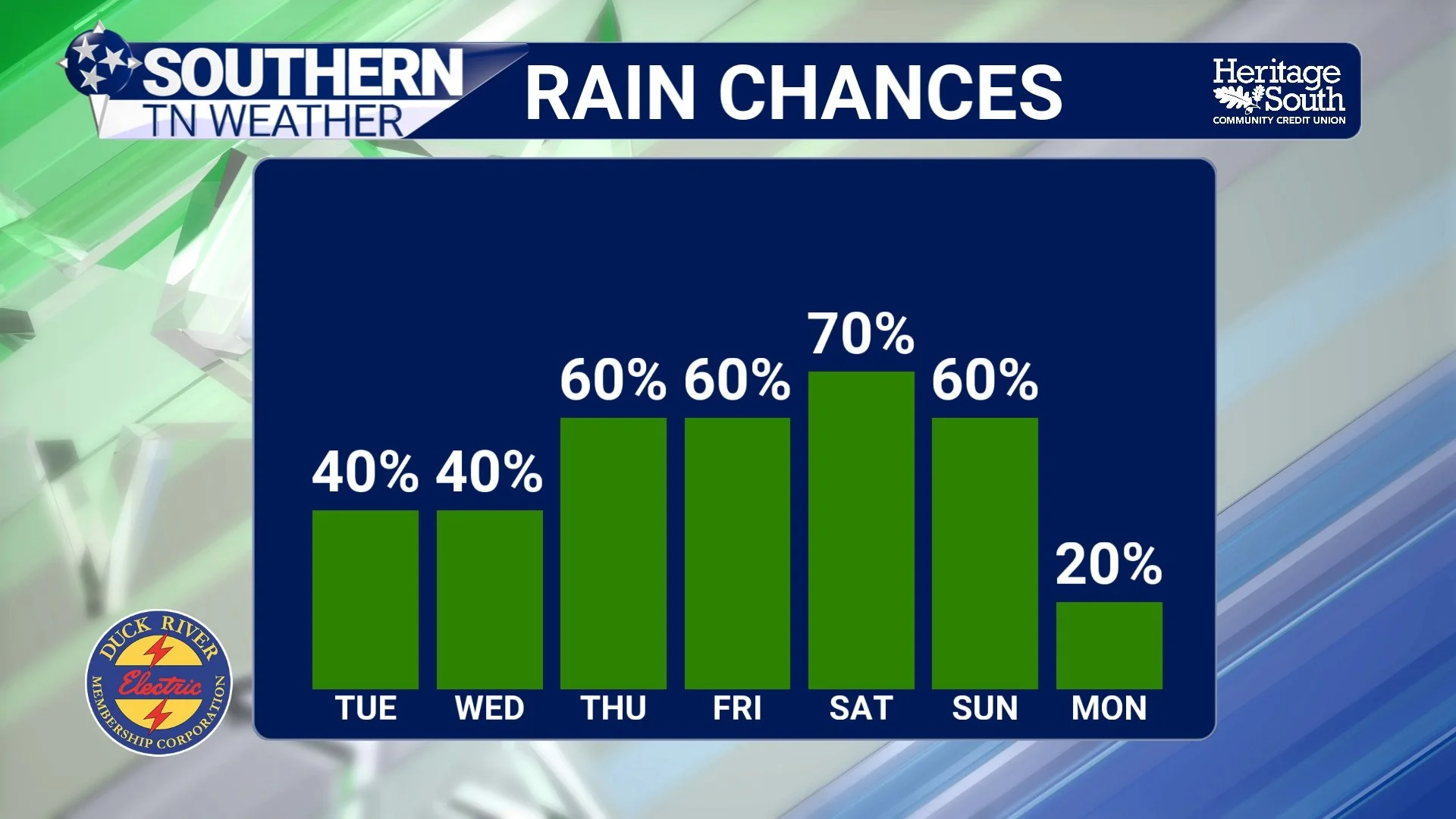
RAIN CHANCES - NEXT 7 DAYS
Temperatures Stay Near Normal
Compared to last week's oppressive heat, this forecast is much easier to handle. High temperatures will generally reach the upper 80s to lower 90s each afternoon, while overnight lows remain around 70 degrees. It'll still feel humid outside, especially during the afternoon, with heat index values occasionally approaching 100 degrees by the middle and latter part of the week. Fortunately, widespread Heat Advisories are not anticipated at this time.
Looking Toward The Weekend
Forecast confidence decreases a bit by Friday and into the weekend, but current guidance suggests shower and thunderstorm coverage may increase once again as a weak frontal boundary drifts toward the Tennessee Valley. That doesn't necessarily mean everyone sees rain, but rain chances do appear a little higher compared to the first half of the week. As always with summertime weather, the exact placement of storms will depend on small-scale boundaries that simply can't be pinned down several days in advance.
We'll continue refining the forecast as we get closer. Overall, the next seven days look very typical for early July across Southern Middle Tennessee: warm afternoons, humid conditions, scattered pop-up thunderstorms, and no signs of any prolonged heat wave or widespread severe weather.
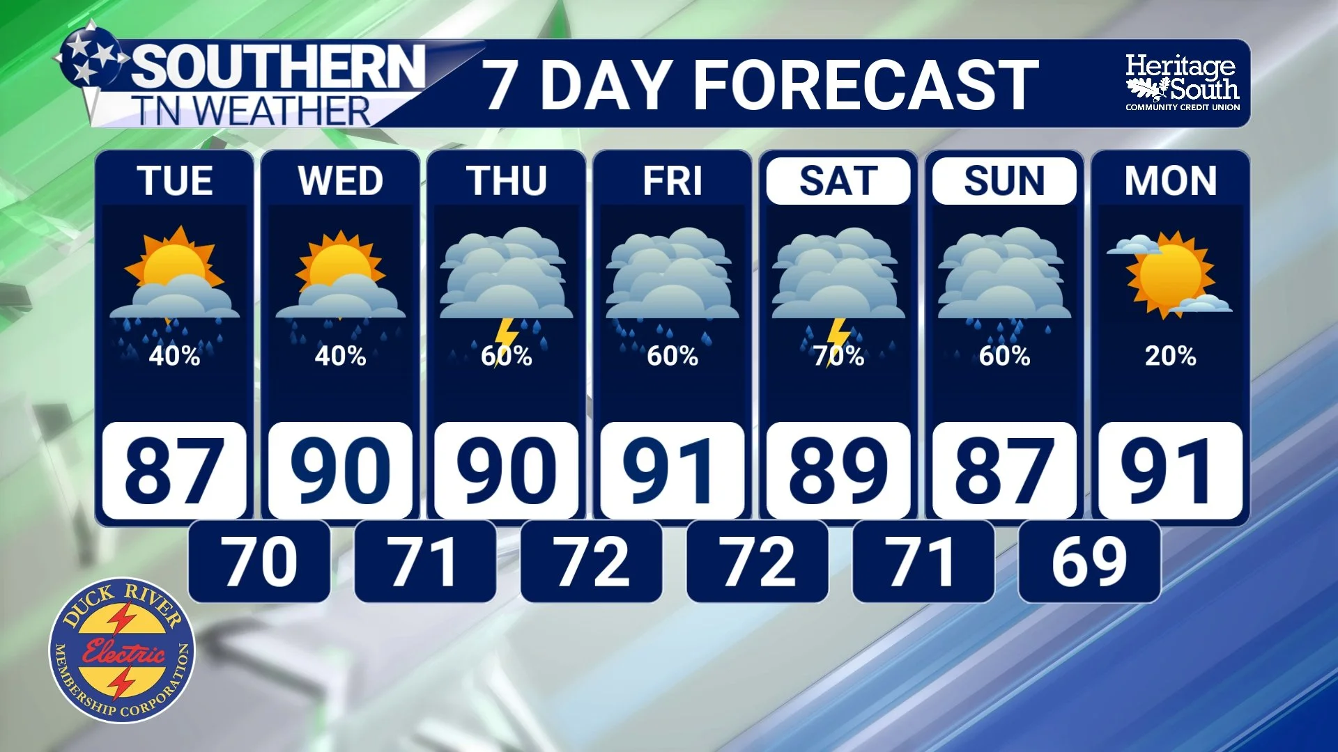
7-DAY FORECAST
The Bottom Line 🧾
Daily afternoon and evening showers and thunderstorms are expected throughout the week.
Widespread severe weather is not expected, although isolated storms could produce gusty winds and heavy rainfall.
Localized flooding is possible where slow-moving storms produce repeated heavy downpours.
High temperatures remain in the upper 80s to lower 90s, with heat index values nearing 100° later this week.
Rain chances may increase a bit heading into the weekend as another weak weather system approaches.
Overall, expect a classic summertime weather pattern across Southern Middle Tennessee over the next seven days.
📰 Reminder: The Southern Tennessee Weather Blog, presented by Heritage South Community Credit Union, is updated Monday through Friday with fresh, locally tailored forecasts you can trust.
