
Friday’s Storm System Coming Into Focus: Newest Details Here

The Southern Tennessee Weather Blog is proudly presented by Heritage South Community Credit Union.
We Help When Others Won’t!
Visit https://www.heritagesouth.org/ today to see how HSCCU can help YOU!
Southern Middle Tennessee remains in the middle of a very un-January-like stretch of weather, with spring-like warmth firmly in place and near-record temperatures likely again tomorrow. While conditions today are calm and comfortable, the larger weather pattern across the central United States is becoming increasingly active. Multiple national forecast centers are now highlighting our region for heavy rainfall and a low-end severe thunderstorm risk on Friday.
The next 36 to 48 hours will be about refinement, not alarm. But the signals in the data are becoming clearer. Friday has the potential to be our most impactful weather day so far in 2026. That doesn’t sound dramatic on paper, considering the year has been quiet so far, but it does mark a meaningful shift toward a more active pattern.
Warm and Quiet Today… But the Pattern Is Rapidly Changing
This afternoon across Southern Middle Tennessee, temperatures are running in the mid to upper 60s under filtered sunshine and high clouds. A developing ridge aloft and persistent southerly flow continue to transport warm, humid air northward into the region. These temperatures are running 10 to 15 degrees above normal, and that warmth will intensify again tomorrow.
Behind the scenes, however, a much stronger system is organizing over the western and central United States. A deep upper-level trough is digging into the Rockies and Plains. As that trough ejects eastward, it will force surface low pressure development, strengthen the jet stream, and open the door for widespread rain and thunderstorms across the Mississippi and Tennessee Valleys.
Thursday: Near-Record Warmth and Increasing Wind
Thursday will feel more like April than January. South to southeast winds will strengthen as pressure falls to our west, helping push highs into the upper 60s to low 70s. A few locations may challenge daily record highs. Wind gusts of 20 to 30 mph will become more common, signaling that the larger-scale storm system is drawing closer.
Most of Thursday remains dry, though a few isolated showers may develop late in the day, especially across western counties. These are not the main event. Thursday’s role is to load the atmosphere with heat and moisture, setting the stage for what follows.
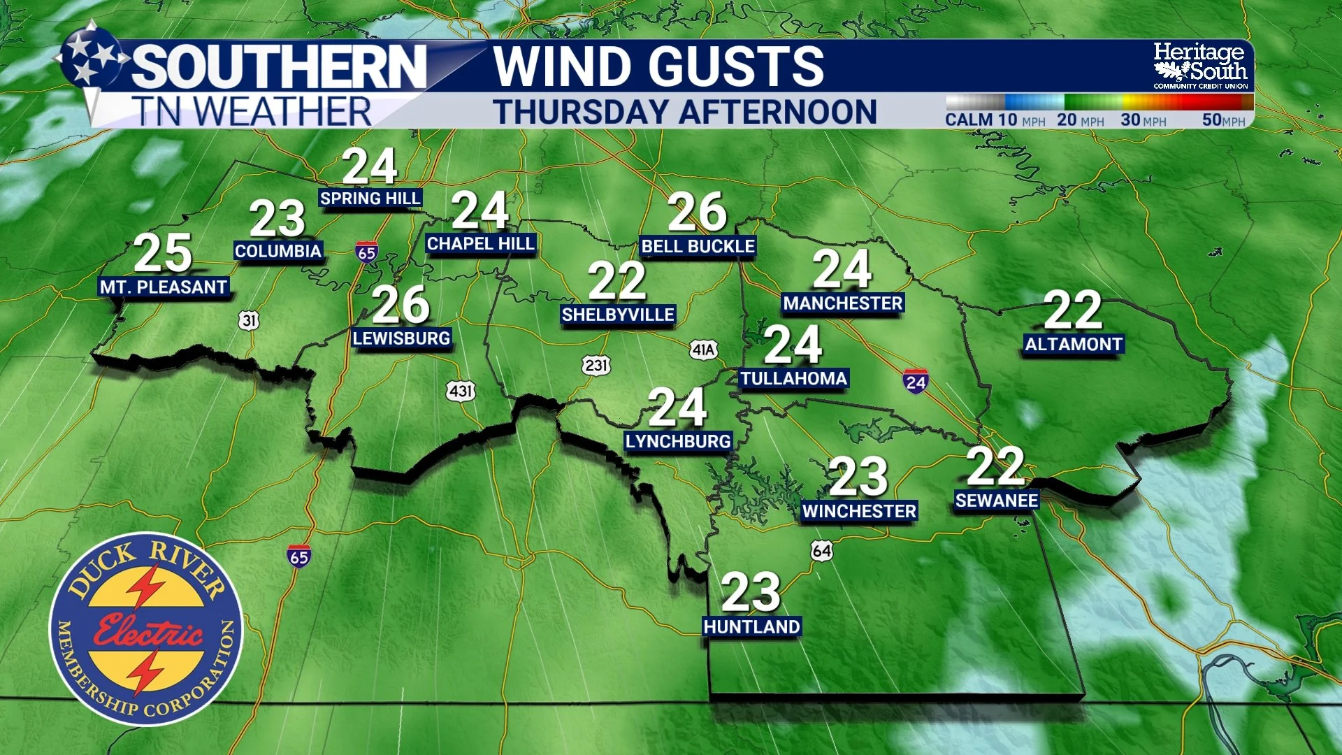
Wind Gust Forecast - Thursday Afternoon
Friday: Heavy Rainfall Becoming the Primary Concern
Friday is the day that has my attention. The Weather Prediction Center is now highlighting portions of northern Alabama into southern and central Tennessee in a Slight Risk for Excessive Rainfall, meaning flash flooding is becoming a legitimate concern. A deep plume of Gulf moisture will surge northward ahead of the approaching cold front. Forecast precipitable water values between 1.25 and 1.50 inches are near the top of the historical range for January. In practical terms, the atmosphere will be loaded with moisture, and any storms that develop will be efficient rain-producers.
Guidance continues to point toward:
• Widespread 2 to 3 inches of rainfall possible
• Localized 4+ inch amounts where storms train
• Multiple rounds of rain and storms rather than one quick line
Winds aloft are forecast to run nearly parallel to the cold front. This favors repeated rounds of rain and storms moving over the same areas, a classic wintertime flash-flood setup in the Tennessee Valley. One important thing to stress: confidence is high that heavy rain will occur somewhere in Southern Middle Tennessee. Confidence is LOWER on exactly where the heaviest swath sets up. That placement will likely shift over the next couple of forecast cycles. Low-lying areas, poor drainage locations, and creeks and streams will need to be monitored closely. If current trends hold, flooding will end up being the primary impact with this system.
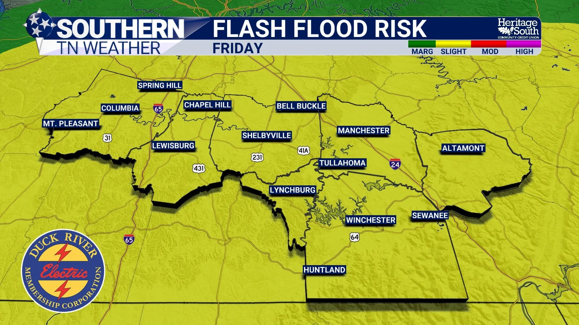
Flash Flood Risk - Friday
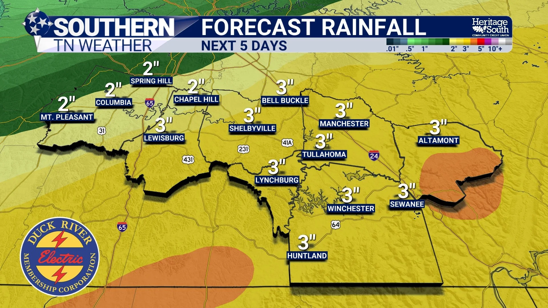
Rainfall Totals - Next 5 Days
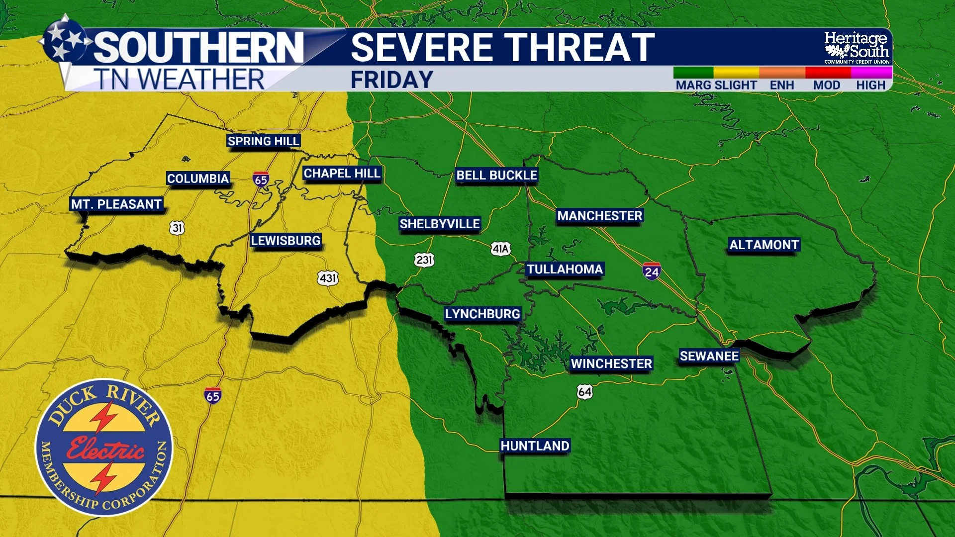
Severe Weather: Low-End, But Not Zero
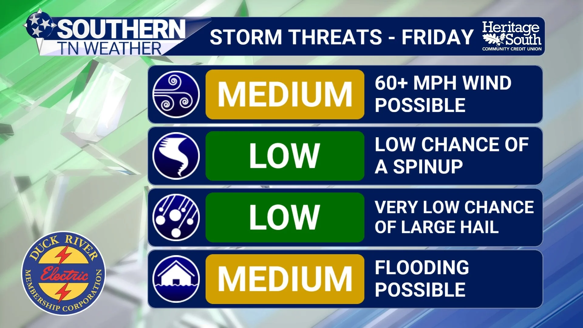
Alongside the heavy rain threat, the Storm Prediction Center has placed parts of the Mid-South and Tennessee Valley in a Level 2 out of 5 Slight Risk for severe thunderstorms on Friday. Locally, this includes Marshall and Maury Counties, with the remainder of Southern Middle Tennessee currently in a Level 1 out of 5 Marginal Risk. The environment on Friday will feature:
• Strong deep-layer wind shear – this refers to how wind speed and direction change with height. Strong shear helps storms organize and persist longer.
• A strengthening low-level jet Friday afternoon and evening – this is a fast-moving ribbon of wind a few thousand feet above the ground that can enhance storm rotation and increase the damaging wind and tornado potential.
• A very warm, moisture-rich air mass in place
What remains uncertain is instability, or storm fuel. Widespread clouds and ongoing rain could limit how much surface-based instability develops. However, even modest instability in a strongly sheared environment can support organized storms. If instability increases more than currently forecast, storms could be capable of producing:
• Damaging wind gusts (primary threat)
• A few tornadoes
• Isolated hail
At this time, the severe threat still appears secondary to the flooding risk, but it cannot be ignored, especially west of Interstate 65, where ingredients may align more favorably. Based on past experiences with these types of setups, I expect the heavy rainfall to win out and help limit our overall severe potential, but still I’m keeping a close eye on things.
SPC Severe Weather Risk - Friday
Storm Threats - Friday
Timing Snapshot (subject to change)
• Thursday night: Showers begin increasing
• Friday morning: First round of rain and storms
• Friday afternoon–night: Highest concern window for heavy rain and strong storms
• Saturday morning: Rain gradually ending west to east
The Bottom Line 🧾
• Spring-like warmth continues through Thursday
• Friday is trending toward a high-impact rain event
• Heavy rainfall could lead to localized flash flooding
• A low but non-zero severe storm threat exists Friday afternoon and evening
• The exact corridor of heaviest rain is still uncertain
• Forecast details will continue to be refined over the next 24 to 36 hours
This is a monitor closely setup. The overall pattern is becoming clearer, but the exact placement of the biggest impacts will not be known until much closer to the event. Now is the time to stay weather-aware, review plans, and check back for updates as higher-resolution data comes into range.
📰 Reminder: The Southern Tennessee Weather Blog (Presented by Heritage South Community Credit Union) is updated Monday through Friday with fresh, locally tailored forecasts you can trust.