
The Heat Peaks Today... Short-Lived Relief Arrives Tomorrow

The Southern Tennessee Weather Blog is proudly presented by Heritage South Community Credit Union.
We Help When Others Won’t!
Visit https://www.heritagesouth.org/ today to see how HSCCU can help YOU!
If you've been counting down the days until this latest stretch of dangerous heat finally comes to an end, I've got some good news. Today is likely the hottest day we'll experience for quite some time.
Afternoon temperatures will climb into the middle and upper 90s across Southern Middle Tennessee, and when you combine that with tropical humidity, heat index values between 105° and 110° will be common. A few communities could briefly feel even hotter, making this another day where heat-related illnesses can develop quickly if you're spending extended time outdoors. The encouraging news is that we've finally reached the peak.
A cold front moving through later today and tonight won't completely erase the summer heat, but it will begin knocking the edge off beginning Wednesday. By Thursday and Friday, many communities will experience some of the most comfortable weather we've had all summer.
One More Round Of Storms (maybe?)
Before we get there, we still have one more weather system to deal with. A cold front sliding south through Middle Tennessee this afternoon and tonight will provide enough lift for scattered showers and thunderstorms to develop, especially across our eastern counties and near the Cumberland Plateau. Not everyone will see rain, and many communities may stay completely dry. However, any storms that do develop could quickly become strong enough to produce gusty winds, torrential downpours, frequent lightning, and localized flooding.
The overall severe weather threat remains low, but it's not zero. The atmosphere will still be very unstable after another day of intense heating, so it won't take much for a few storms to briefly become strong before weakening later tonight as the front continues pushing south.
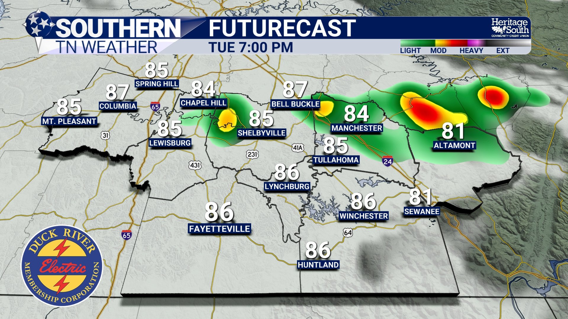
FUTURECAST - THIS EVENING
Wednesday Brings The First Signs Of Relief
You'll probably notice the difference as soon as you step outside Wednesday morning. Behind the cold front, winds will turn out of the north, allowing slightly drier air to move into the region. While afternoon highs will still reach the upper 80s to around 90 degrees, dew points will begin falling into the upper 60s.
That may not sound like much, but after several days with tropical humidity and heat index values above 105 degrees, it'll feel noticeably more comfortable. Wednesday won't be cool by any means, BUT compared to what we've been dealing with lately, it'll be a welcome improvement.
The Best Weather Arrives Thursday And Friday
If you've been waiting to mow the yard, spend time outside, or simply enjoy a break from the heat, the end of the workweek looks fantastic. Thursday and Friday should feature afternoon highs in the middle to upper 80s while dew points fall into the lower and middle 60s. That's about as comfortable as late July gets across Tennessee. Skies should also remain mostly dry through Friday, making this an excellent stretch of weather for any outdoor plans.
Unfortunately, the break won't last forever… Forecast confidence continues to increase that another organized weather system will move into the area Friday night and Saturday, bringing widespread showers and thunderstorms back to the region. Right now, heavy rainfall appears to be the primary concern, and the Weather Prediction Center has already highlighted Middle Tennessee in a Slight Risk for Excessive Rainfall on Saturday. While the severe weather threat appears fairly limited at this time, we'll continue watching trends over the next few days.
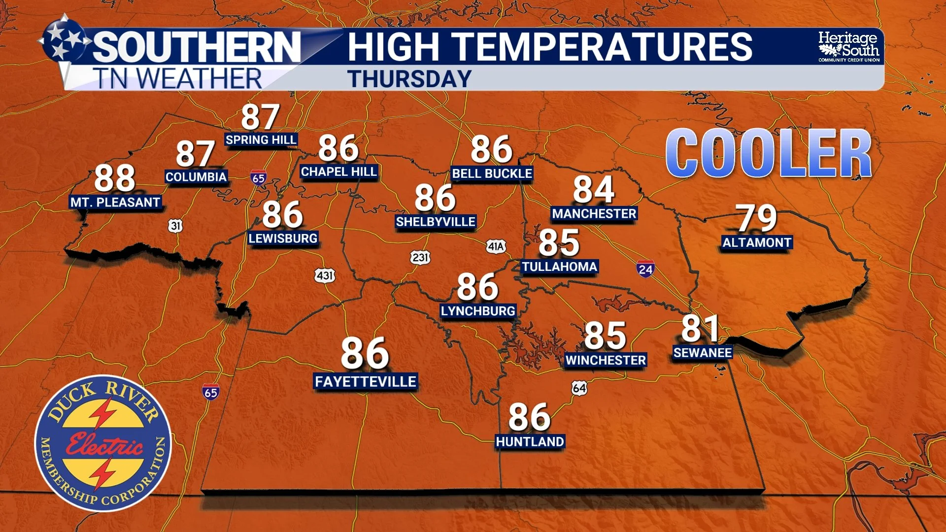
HIGH TEMPS - THURSDAY
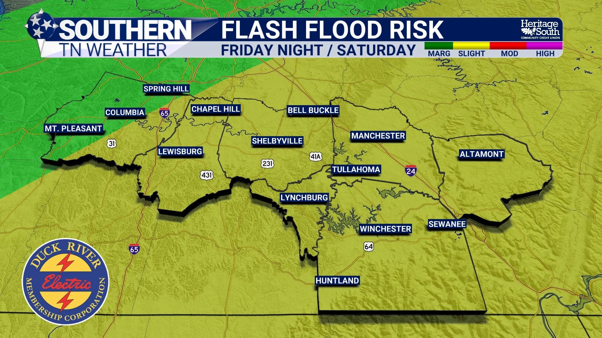
FLASH FLOOD RISK - FRIDAY NIGHT / SATURDAY
Enjoy The Break While It Lasts
This week is a good reminder that not all heat waves last forever. After peaking today, temperatures and humidity will gradually trend downward through the second half of the week, giving us a refreshing break before another unsettled pattern develops this weekend.
If you've been waiting for a reason to get back outside... Thursday and Friday may be your best opportunity.
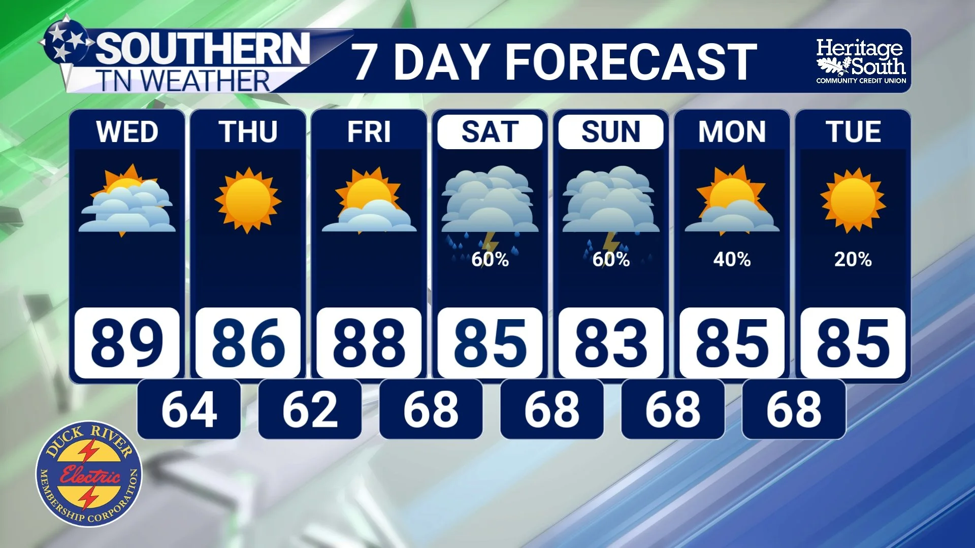
STNWX 7-DAY FORECAST
The Bottom Line 🧾
🥵 Today is the hottest day of the week, with heat index values between 105° and 110°+.
⛈️ Scattered thunderstorms develop this afternoon and tonight, especially near the Cumberland Plateau. A few could produce gusty winds, heavy rainfall, and frequent lightning.
🌬️ A cold front moves through tonight, bringing the first signs of relief on Wednesday.
😌 The nicest weather of the week arrives Thursday and Friday, with highs in the 80s and noticeably lower humidity.
🌧️ Rain and thunderstorm chances return Friday night into the weekend, with heavy rainfall currently appearing to be the primary concern.
📰 Reminder: The Southern Tennessee Weather Blog, presented by Heritage South Community Credit Union, is updated Monday through Friday with fresh, locally tailored forecasts you can trust.
