
Behind The Forecast: Why Has The Weather Been So Hard To Predict Lately?

The Southern Tennessee Weather Blog is proudly presented by Heritage South Community Credit Union.
We Help When Others Won’t!
Visit https://www.heritagesouth.org/ today to see how HSCCU can help YOU!
If you've been following Southern Tennessee Weather over the past couple of weeks, you've probably noticed something. The forecast has... evolved. Quite a bit. One day we're talking about storms arriving around midnight. A few hours later, the arrival time shifts to 3:00 AM. Then the storms weaken before they ever make it here. The next night, another complex develops that wasn't expected to amount to much, only to strengthen as it approaches Middle Tennessee.
I know that can be frustrating. Believe me... it's just as frustrating from this side of the forecast desk. One of the things I've always tried to do is be transparent about the forecast, and I thought this would be a good opportunity to pull back the curtain and explain why the forecast has seemed so "wishy-washy" lately. The short answer is that we've been stuck in one of the most difficult summertime weather patterns meteorologists have to forecast.
Meet "Northwest Flow"
For much of July, a large dome of high pressure has been parked over the central United States. Instead of weather systems moving directly across Tennessee, thunderstorms have been riding around the outer edge of that ridge before diving southeast toward us. Meteorologists call this northwest flow, and it's infamous among forecasters.
The reason is simple: many of the storms affecting us don't actually form here. Instead, they develop several hundred miles away across states like Missouri, Illinois, Indiana, Kentucky, or Ohio before racing toward Tennessee overnight. Those storms are called Mesoscale Convective Systems, or MCSs. They're large clusters of thunderstorms that can travel for hundreds of miles while constantly changing in size, strength, and direction. And that's where forecasting gets tricky.
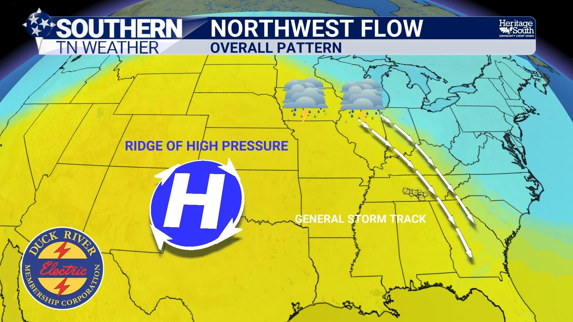
NORTHWEST FLOW - OVERALL PATTERN
The Storms Create Their Own Forecast
Unlike a cold front or a winter storm, these thunderstorm complexes don't simply move from Point A to Point B. As they travel, they change the atmosphere around them. Heavy rainfall produces pools of cooler air. Strong winds create new outflow boundaries. Those boundaries then become the focus for the next round of thunderstorms. In other words, every storm complex is constantly rewriting the atmosphere for the one behind it. It's almost like trying to predict the path of a crowd after someone unexpectedly closes a busy highway. One small change early on can completely alter where everything ends up later.
That's why a storm complex can look incredibly impressive over Kentucky at 9:00 PM, then completely fall apart before reaching us. Other times, the exact opposite happens. A cluster of storms that appears to be weakening suddenly taps into a more unstable atmosphere and strengthens right before arriving. Sometimes those changes happen within the span of an hour.
"But Don't The Weather Models Know?"
This is probably one of the questions I receive the most. The answer is... not always. Weather models do an excellent job forecasting large-scale weather systems like hurricanes, winter storms, and strong cold fronts several days in advance because those systems are relatively well-organized. Thunderstorm complexes like we've been dealing with lately are much smaller and far more chaotic.
In many cases, the storms we're trying to forecast haven't even formed yet when the computer models begin their calculations. Once they do form, they immediately begin changing the atmosphere around them in ways that are nearly impossible for any model to perfectly simulate. That's why you've probably heard me use phrases like "low confidence," "conditional," or "questionable" more than usual recently. Those aren't cop-outs. They're simply an honest reflection of how complicated the atmosphere has been.
We're Almost Through It
The good news is that we're finally approaching the end of this frustrating pattern. Dangerous heat remains the primary concern through Tuesday, with heat index values between 105° and 110°, and a few communities could briefly exceed that Tuesday afternoon. If you have to be outdoors, stay hydrated, take frequent breaks, and avoid strenuous activity during the hottest part of the day whenever possible.
We're also watching one more opportunity for thunderstorms tonight as yet another storm complex develops well to our north. Confidence remains lower than average regarding exactly how much of that activity survives into Southern Middle Tennessee. Then on Tuesday afternoon and evening, a cold front dropping south through the region should spark another round of scattered thunderstorms capable of producing gusty winds, torrential rainfall, and frequent lightning. After that front moves through Tuesday night, however, the atmosphere finally settles down.
Wednesday through Friday look absolutely fantastic by late July standards. Humidity levels will fall dramatically as dew points drop into the 60s, afternoon highs return to the 80s, and overnight lows become much more comfortable. While rain chances will eventually increase again next weekend, they'll be associated with a more traditional weather system instead of the unpredictable overnight storm complexes we've been battling for weeks.
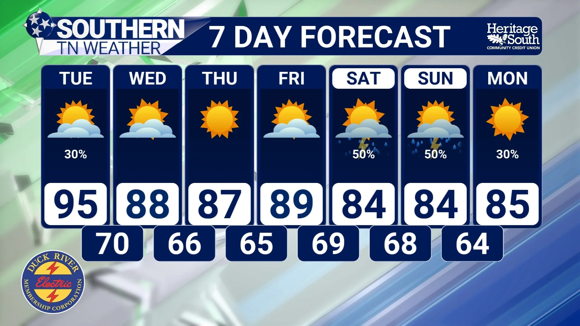
STNWX - 7 DAY FORECAST
A Little Honesty
Weather forecasting isn't about trying to be perfect. It's about taking the best science available, understanding its limitations, and communicating the uncertainty as honestly as possible. Over the past couple of weeks, Mother Nature has reminded us that the atmosphere doesn't always follow a script. Sometimes the forecast changes because the atmosphere changes.
Thankfully, it looks like both the weather (and the forecast) will become much more straightforward after Tuesday. And if I'm being honest... I think both you and your meteorologist (ME) are ready for that.
The Bottom Line 🧾
🌩️ We've been stuck in a northwest flow weather pattern, one of the most difficult summertime setups to forecast.
🛰️ Overnight storm complexes have been forming hundreds of miles away and constantly changing as they move toward Tennessee.
🖥️ Weather models struggle with these events because the storms create their own boundaries and continuously modify the atmosphere.
🥵 Dangerous heat continues through Tuesday with heat index values between 105° and 110°+.
⛈️ One more round of thunderstorms is possible tonight and Tuesday before a cold front moves through Tuesday evening.
😌 Much drier, less humid air arrives Wednesday and sticks around through at least Friday, bringing a much more predictable stretch of weather.
📰 Reminder: The Southern Tennessee Weather Blog, presented by Heritage South Community Credit Union, is updated Monday through Friday with fresh, locally tailored forecasts you can trust.
