
Flooding Remains the Main Concern as Rounds of Rain Continue

The Southern Tennessee Weather Blog is proudly presented by Heritage South Community Credit Union.
We Help When Others Won’t!
Visit https://www.heritagesouth.org/ today to see how HSCCU can help YOU!
It was a rainy morning across Southern Middle Tennessee! While the severe weather threat has trended lower over the past 24 hours, the isolated flooding threat remains. Multiple rounds of rain are expected to continue through tonight and into Saturday, and while forecast totals have come down some, enough rain has already fallen (and more is still to come) to support localized flooding concerns.
Where We Stand Right Now (Friday Midday)
Widespread showers moved across the region earlier today. Lightning activity has been very limited, which confirms what the data has been showing — instability is weak, and the atmosphere has largely been “worked over” by earlier rainfall. Some breaks in the rain are occurring behind the morning wave, but this is not the end of the system.
So far, rainfall amounts have generally ranged from around a half inch in some southeastern locations to over an inch across much of the rest of Southern Middle Tennessee. That first round has moistened soils and increased runoff efficiency, meaning any additional rainfall will have a greater impact. Our primary concern going forward remains heavy rainfall and localized flooding.
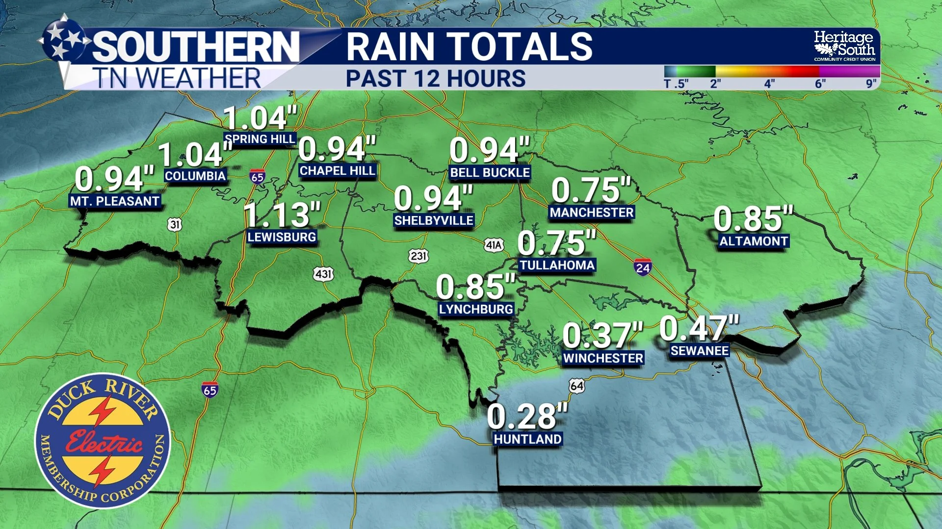
Rain Totals - Past 12 Hours
What Happens Next: Round #2 Tonight
High-resolution guidance continues to indicate redevelopment near the Alabama state line this evening, with rain spreading northward across Southern Middle Tennessee through the evening and overnight hours. The most likely window locally is roughly 8 PM tonight through Saturday morning.
This round may contain embedded thunderstorms, but severe weather looks unlikely. The atmosphere is quite saturated and instability remains limited. However, any storms that do form will be capable of producing locally heavy downpours. Rain will not fall continuously every minute, but periods of steady rain with heavier bursts are expected through the night.
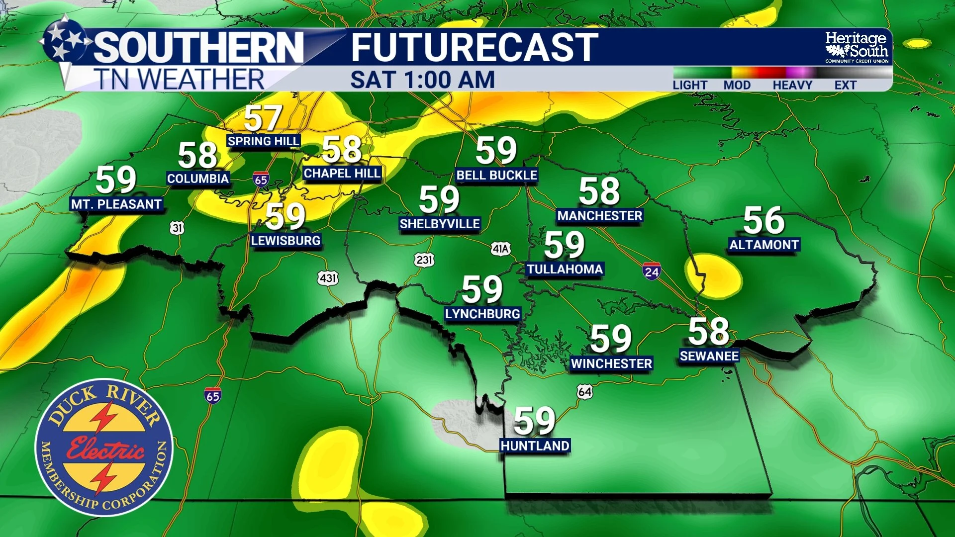
Futurecast - Round #2
Rainfall Totals and Flooding Risk
Storm-total rainfall across Southern Middle Tennessee is now forecast to generally fall in the 1 to 3 inch range, with locally higher totals still possible, especially toward our southeastern counties. (Important note: these totals include rainfall that already occurred this morning.) While the main heavy-rain axis remains favored south and east of our area, probabilities still support pockets of heavier rainfall locally. National Weather Service guidance indicates:
• Around a 5% chance of exceeding 3 inches near Nashville
• Increasing to around a 20% chance across Grundy County
Those numbers may not sound high, but when rain falls repeatedly over the same areas, even lower probabilities can still produce isolated flooding problems. Potential impacts include:
• Ponding on roadways and in low spots
• Rapid rises on creeks and small streams
• Localized flash flooding in poor-drainage areas
A Flood Watch remains in effect, and while major river flooding is not expected, isolated flooding issues are possible through tonight and Saturday morning. Remember: Turn Around, Don’t Drown.
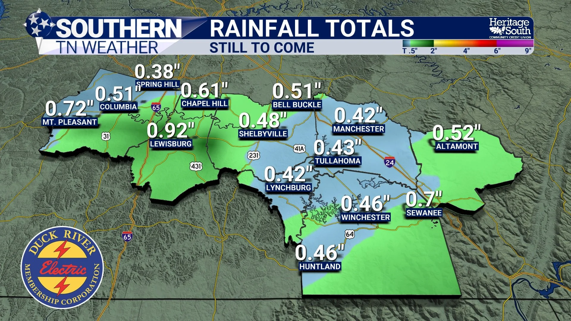
Rain Totals - Round #2
Saturday: Rain Ending in the afternoon, Cooler Air Arrives
Rain will continue into late Saturday morning, especially east of I-65, before tapering off from west to east as the cold front moves through. We should begin drying out after lunchtime, though a little leftover drizzle may linger in spots. Behind the front, winds will turn northwest and cooler, drier air will move in. Temperatures will fall steadily through the day. Sunday looks dry, breezy, and noticeably colder, with highs mainly in the 40s and lows dropping into the 20s.
Not to stir the pot yet, but I am watching a few signals for snowflakes over the next 7–10 days. There is still a lot to be worked out, and I am not confident in any accumulating or impactful snow at this time — just something on the long-range radar.
The Bottom Line 🧾
• Additional rounds of rain continue tonight into Saturday
• Flooding remains the primary concern across Southern Middle Tennessee
• 1–3 inches of total rainfall expected, with localized higher amounts
• Rain ends Saturday, followed by a cooler, drier Sunday
Stay informed by following Southern Tennessee Weather on social media, using the Southern Tennessee Weather App, and tuning into our 24/7 weather channel as conditions evolve. If any flood advisories or warnings are issued, act quickly and never drive across flooded roads.
📰 Reminder: The Southern Tennessee Weather Blog (Presented by Heritage South Community Credit Union) is updated Monday through Friday with fresh, locally tailored forecasts you can trust.