
Active Weather Over the Next 48 Hours

The Southern Tennessee Weather Blog is proudly presented by Heritage South Community Credit Union.
We Help When Others Won’t!
Visit https://www.heritagesouth.org/ today to see how HSCCU can help YOU!
Southern Middle Tennessee is entering its most active stretch of weather so far in 2026. After an unusually warm and mostly quiet start to January, multiple rounds of showers and thunderstorms are expected from late tonight through Friday night. This does not appear to be a major, high-end flooding or severe weather outbreak for our area. However, it will bring meaningful impacts — particularly the potential for localized flooding and a low-end severe storm risk.
Recent model trends have shifted the primary axis of heaviest rainfall southward into Alabama and Mississippi. That shift lowers the likelihood of widespread or major flooding in Southern Middle Tennessee — but it does not remove the risk. With repeated rounds of rain expected, even a south-shifted setup can still produce pockets of heavy rain and localized flooding here. This is a system to approach with awareness and preparation, not alarm. Either way, a widespread beneficial rainfall is on the way for all of Southern Middle Tennessee.
Today (Thursday): Warm, Windy, and Setting the Stage
Cloud cover remains widespread across Southern Middle Tennessee this afternoon, with temperatures holding in the 60s. Winds are increasing from the south and southeast and will continue strengthening through tonight. These winds are transporting warm, humid air northward from the Gulf of Mexico — a process called warm air advection. This steadily deepens moisture across the region and is one of the key ingredients setting the stage for rain and thunderstorms to develop later tonight and persist through Friday.
Most of today stays dry, but conditions upstream are changing rapidly. A deep storm system over the Plains is strengthening and beginning to move east, which will drive our active weather period.
Late Tonight into Friday Morning: ROUND ONE
Our first round of showers and thunderstorms is expected to arrive around or shortly before daybreak Friday, spreading west to east across the region. The primary window for this round is roughly 4 AM to 12 PM Friday. Some light rain may occur outside this window, but this will be the first organized period of widespread rainfall.
Instability will still be limited, meaning storms should remain mostly elevated. A brief stronger storm or gusty wind can’t be ruled out, but the primary impact with Round One will be rainfall. This first wave is important because it will pre-soak the ground, increasing sensitivity to later rainfall. Rainfall amounts with this round could exceed 1 inch a few locations across the area.
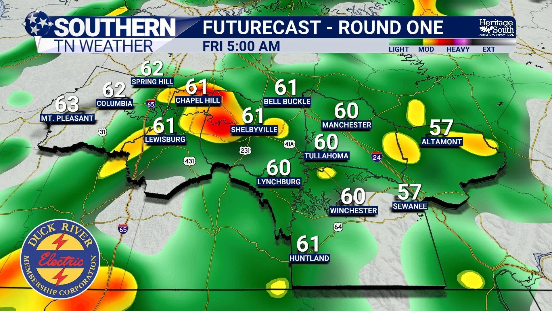
HRRR Futurecast - Friday Morning
Friday Afternoon Through SATURDAY MORNING: ROUND TWO
After a possible lull or lighter rain at times midday, the second round develops as the main system approaches. The primary window for this activity is roughly 6 PM Friday through around midday Saturday. It will not rain continuously the entire time — but rain will fall during much of this window, with multiple waves of showers and a few thunderstorms moving through. The atmosphere will be unusually moist for January. That means storms will be capable of producing efficient, heavy downpours. Winds aloft will also run nearly parallel to the advancing front, which raises concern for repeating bands of rain.
Forecast guidance continues to support:
• Periods of heavier rainfall
• Storms capable of producing efficient rainfall
While the highest confidence for excessive rainfall is now south of our area, Southern Middle Tennessee remains very much in the zone where localized flooding is possible. Rainfall totals across our area are currently forecast to range 1 to 3 inches, with the highest amounts favored toward our southeastern counties, including Franklin and Grundy. Isolated higher totals would be possible if heavier rain bands drift farther north than currently projected.
Potential impacts include:
• Ponding on roadways
• Rises in creeks and small streams
• Flooding of low-lying or poor-drainage areas
At this time, major river flooding or a widespread flash flood event appears unlikely locally. However, isolated flooding issues are very possible, especially where heavier rain bands repeat. A Flood Watch has been issued to account for this threat.
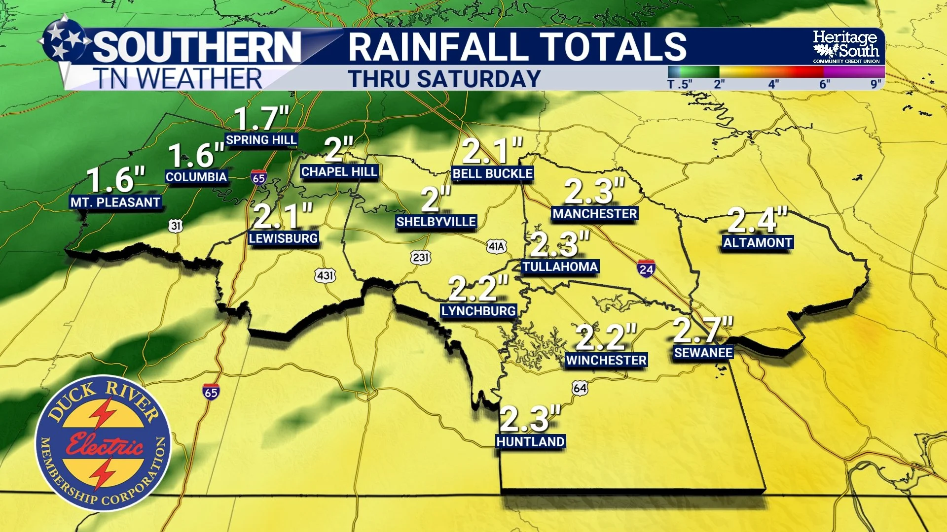
National Blend of Models - Rainfall Totals through Saturday
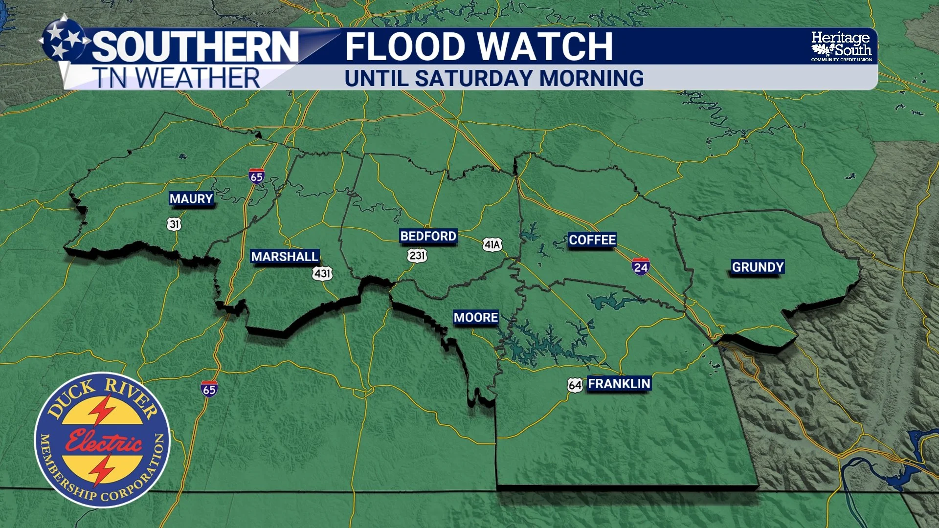
NWS Flood Watch
Severe Weather: Low-End Risk, Still Being Monitored
Southern Middle Tennessee is currently in a Level 1 of 5 (Marginal) risk for severe thunderstorms on Friday. This reflects a low, but not zero, threat. The environment will feature strong wind shear, meaning storms that develop could become organized. The main limiting factor remains instability — the fuel storms need to intensify. If instability stays weak (which is the current expectation), storms will mainly produce heavy rain and occasional gusty winds. If instability increases more than forecast, a few storms could become stronger.
Possible hazards include:
• Isolated damaging wind gusts
• A very low tornado threat
There are two timeframes we will be watching for any stronger storms:
• Timeframe #1: (6 AM – 12 PM) — very low, conditional severe potential
• Timeframe #2: (4 PM – 10 PM) — conditional severe potential depending on how much recovery occurs between the two rounds of rain
How much clearing and heating we get Friday afternoon will play a major role in determining whether any stronger storms can develop. These windows reflect severe potential, NOT rainfall timing. Severe weather is not the primary concern with this system (flooding remains the bigger issue) but it is something we will continue monitoring closely.
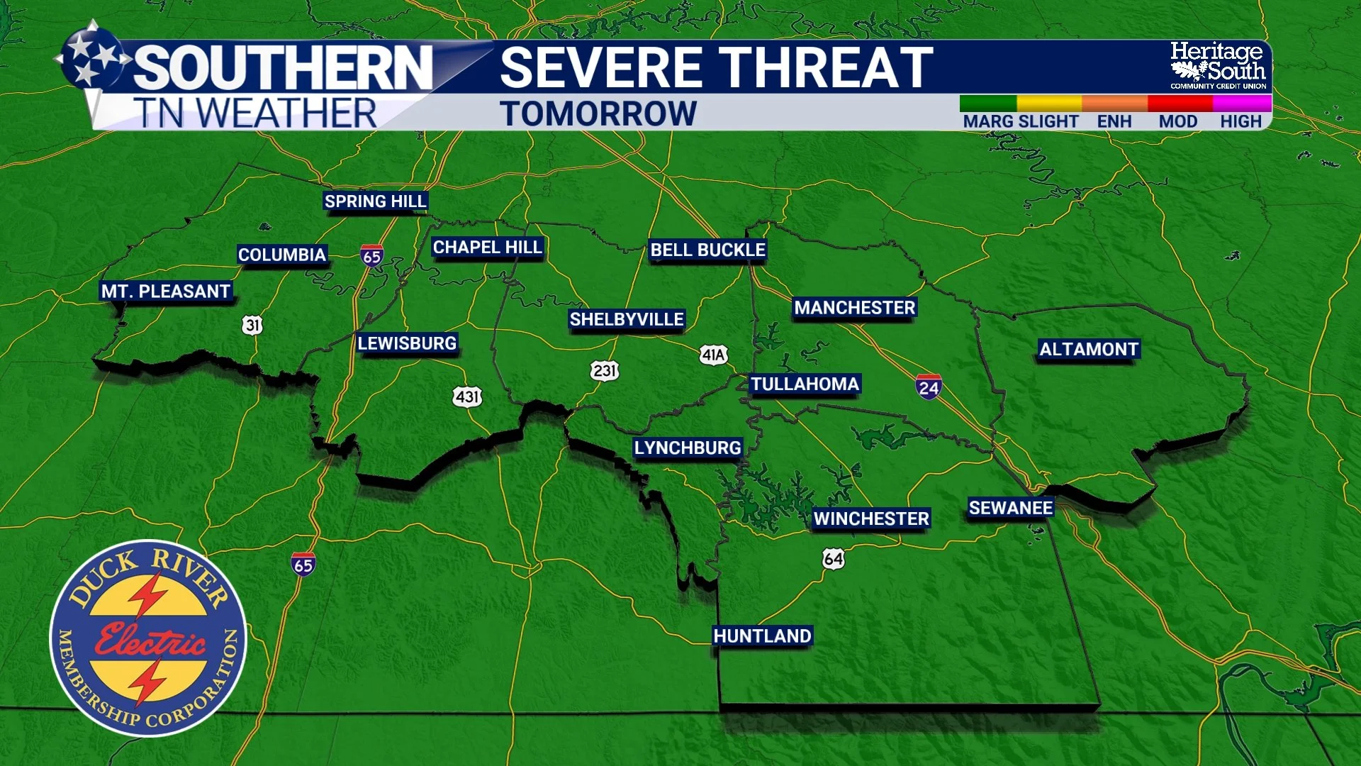
Severe Weather Risk Zone - Friday
Gradual Improvement COMING SOON
Rain tapers off Saturday afternoon as the cold front clears the area. Drier air filters in and temperatures begin to fall. Sunday looks cooler, drier, and much more seasonable.
The Bottom Line 🧾
• Multiple rounds of rain and storms arrive late tonight through Saturday morning
• The main heavy rain axis has shifted south — lowering our risk for major flooding
• Localized flooding still remains possible across Southern Middle Tennessee, with a FLOOD WATCH in effect
• Severe storm risk is low (Level 1/5), but not zero, Friday afternoon and evening
Stay informed by following Southern Tennessee Weather on social media, using the Southern Tennessee Weather App, and tuning into our 24/7 weather channel for updates as this system evolves!
📰 Reminder: The Southern Tennessee Weather Blog (Presented by Heritage South Community Credit Union) is updated Monday through Friday with fresh, locally tailored forecasts you can trust.