
A Few Rain Chances… But Limited Rainfall

The Southern Tennessee Weather Blog is proudly presented by Heritage South Community Credit Union.
We Help When Others Won’t!
Visit https://www.heritagesouth.org/ today to see how HSCCU can help YOU!
THE BIG PICTURE: A PATTERN THAT LOOKS ACTIVE… BUT ISN’T
At first glance, the forecast almost looks encouraging. You see multiple mentions of rain this week, another round this weekend, and even some storm chances mixed in. But when you dig a little deeper into the setup, a different story starts to emerge.
We are currently sitting in what we call an early-season Bermuda High pattern. High pressure is anchored to our southeast, pumping in warm air and keeping the atmosphere relatively stable. At the same time, disturbances and fronts are trying to approach from the west and northwest. Here’s the problem. That high pressure is acting like a shield. It weakens systems as they approach and limits how much moisture and lift can actually reach us. So while rain chances are technically there… the environment just isn’t very supportive of widespread or heavy rainfall.
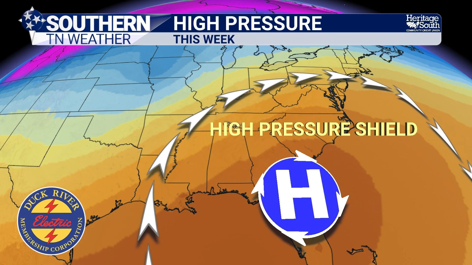
HIGH PRESSURE - THIS WEEK
THURSDAY: A GOOD EXAMPLE OF THE PROBLEM
Thursday is a perfect case study. A boundary will slide into the region with enough lift and a little bit of instability to generate showers and a few thunderstorms. On paper, that sounds promising.
But the air mass ahead of it is still relatively dry, especially as you move south and east across Southern Middle Tennessee. As that boundary pushes in, it begins to weaken. Moisture becomes more limited, and rainfall coverage starts to break apart. This is why forecast rainfall totals taper off from northwest to southeast. Areas closer to Kentucky have a better shot at measurable rain, while many locations farther south towards our area will likely see very little. Even where rain does fall, amounts look light. This is not a drought-busting setup!
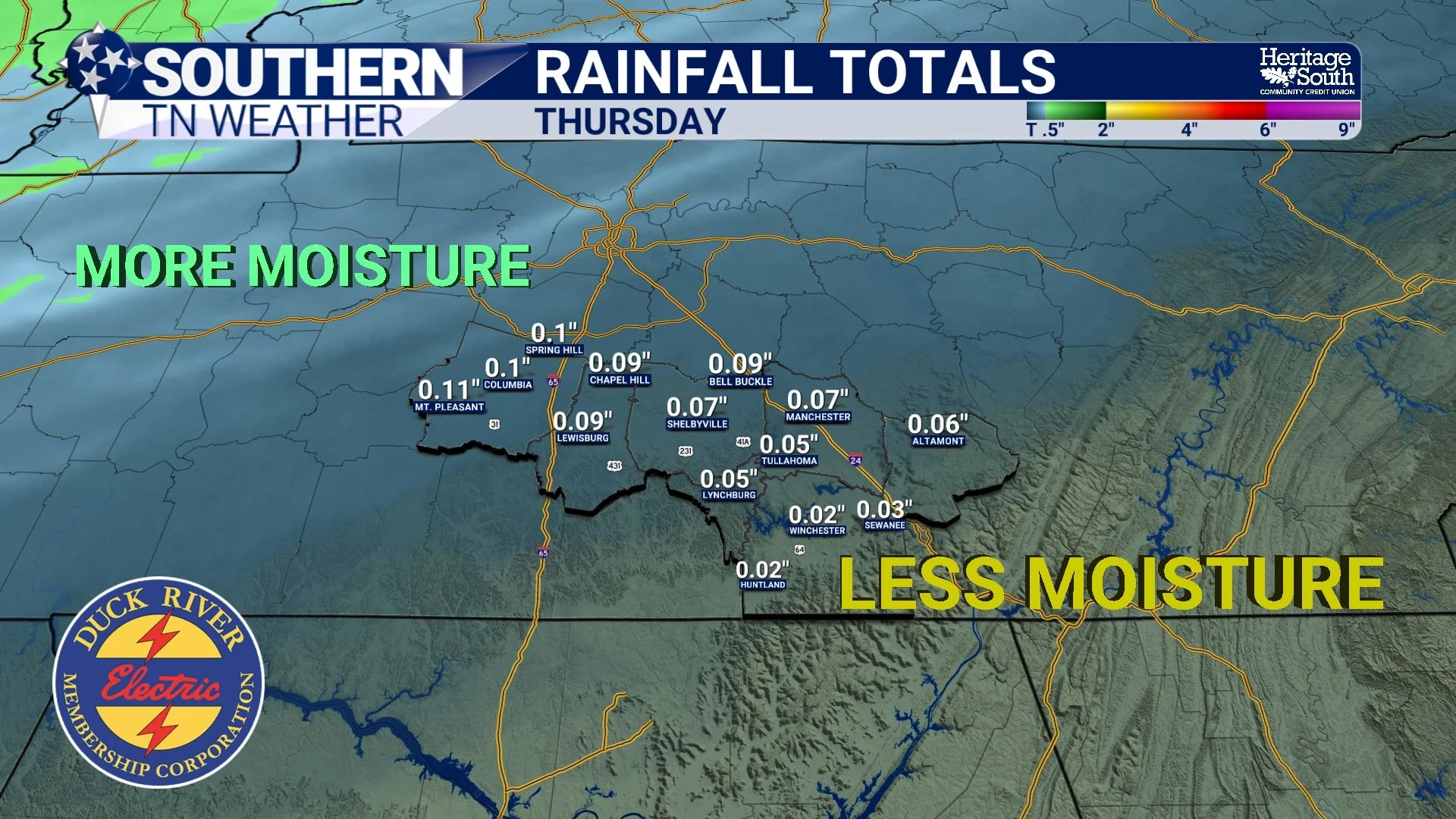
RAINFALL TOTALS - THURSDAY
THE WEEKEND SYSTEM: MORE OF THE SAME, JUST STRONGER
Now let’s talk about the weekend. A stronger cold front will move in Saturday into Saturday night. This one has better dynamics overall, and you would normally expect a more widespread rain event. But once again, the pre-frontal air mass is working against us. The atmosphere ahead of the front is expected to be very dry, and that limits how efficiently storms can develop and produce rainfall.
In fact, much of the convection may actually develop along and behind the front rather than ahead of it. That is what we call a more post-frontal setup, and it tends to reduce both severe weather potential and rainfall efficiency. So yes, rain chances go up this weekend. But confidence in meaningful rainfall totals is still not very high.
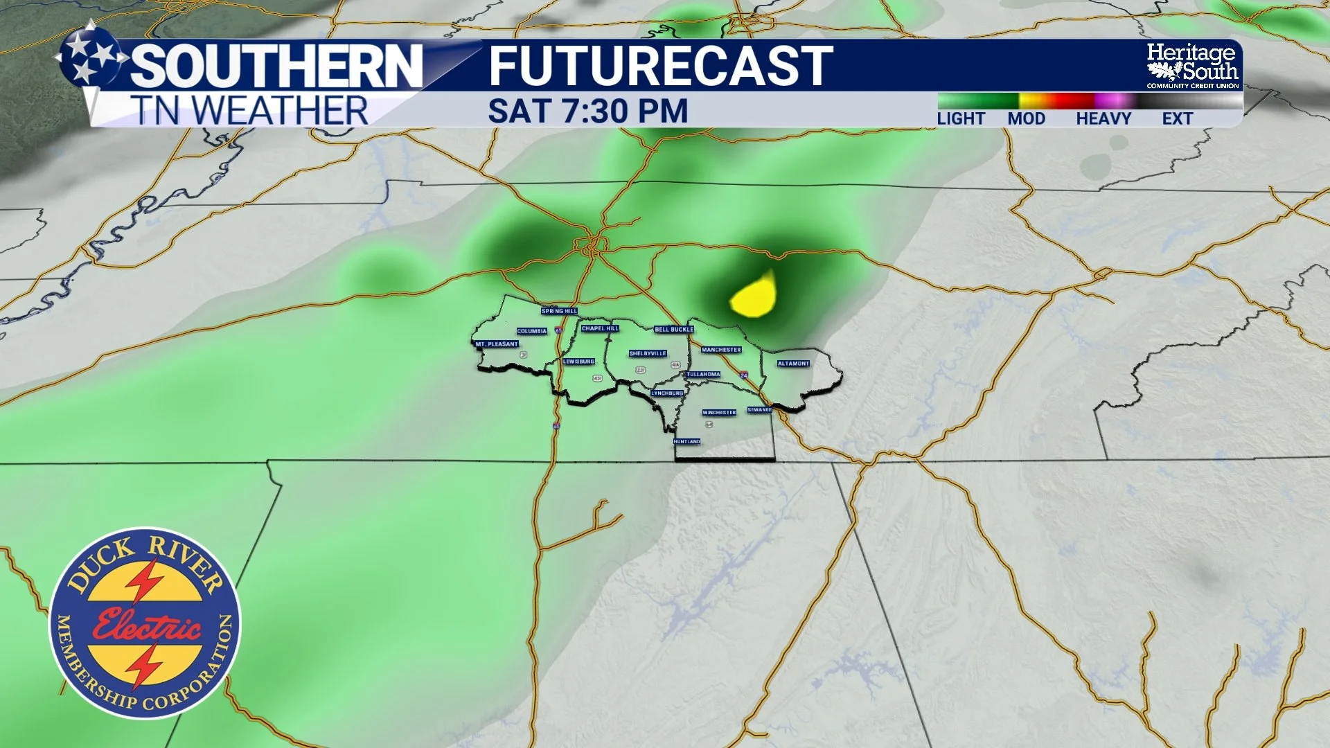
FUTURECAST - SATURDAY
WHAT THIS MEANS FOR THE DROUGHT
This is the bigger concern. We keep getting these “opportunities” for rain, but the pattern just isn’t delivering. Either the systems weaken, the moisture is limited, or the timing isn’t ideal. It’s like having multiple chances to score, but never quite getting the ball across the goal line.
Until we see a stronger, more moisture-rich system break through this pattern, drought conditions are going to continue creeping in across Southern Middle Tennessee.
THE OTHER SIDE OF THE COIN: HEAT AND DRY AIR
While all this is happening, temperatures continue to run well above normal. Highs will push into the mid to upper 80s Wednesday and Thursday, which is about 10 degrees above average for mid-April. That warmth, combined with relatively low humidity and occasional gusty winds, continues to dry things out even more.
It’s a feedback loop. Warm, dry air limits rainfall, and the lack of rainfall allows that warm, dry pattern to persist. There is a bit of good news, though. We will see some relief from the summer-like temps early next week, thanks in part to the cold front on Sunday.
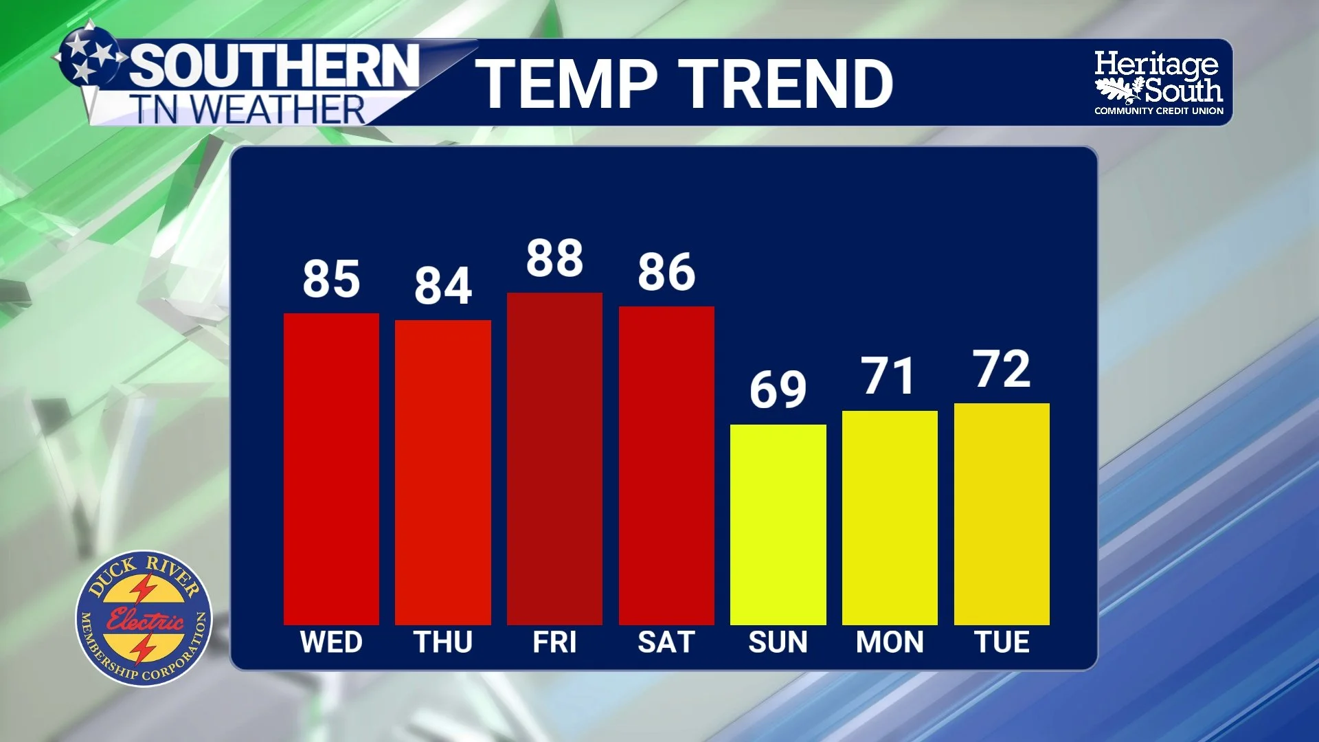
TEMPERATURE TREND
The Bottom Line 🧾
Multiple rain chances this week, but most look light and spotty
Thursday brings scattered showers and storms, but limited totals
Weekend cold front offers better chances, but still uncertain rainfall amounts
Continued warmth and dry conditions are allowing drought concerns to grow
📰 Reminder: The Southern Tennessee Weather Blog, presented by Heritage South Community Credit Union, is updated Monday through Friday with fresh, locally tailored forecasts you can trust.