
Easter Weekend Forecast: Rain Moves In… Then A Spring Cooldown

The Southern Tennessee Weather Blog is proudly presented by Heritage South Community Credit Union.
We Help When Others Won’t!
Visit https://www.heritagesouth.org/ today to see how HSCCU can help YOU!
If you’ve enjoyed the early taste of summer this week, soak it in today… because the pattern is about to flip just in time for Easter weekend. Southern Middle Tennessee will go from warm, breezy, and dry… to a period of widespread rain Saturday… and then back to cooler, more typical April weather by Easter Sunday.
The good news is that while storms are expected, the overall severe weather threat remains LOW. That is something I have been emphasizing all week, and the latest data continues to support that.
One More Warm Day Before the Change
This afternoon is another classic warm-sector setup. Southerly winds continue to pull in warm and slightly humid air from the Gulf, pushing temperatures into the 80s once again. A tightening pressure gradient is keeping things breezy, and that mixing is helping temperatures climb efficiently.
There is just enough moisture and weak lift for a stray shower, but most of us will stay dry through the rest of today. Tonight will stay mild as well, with lows only dropping into the 60s.
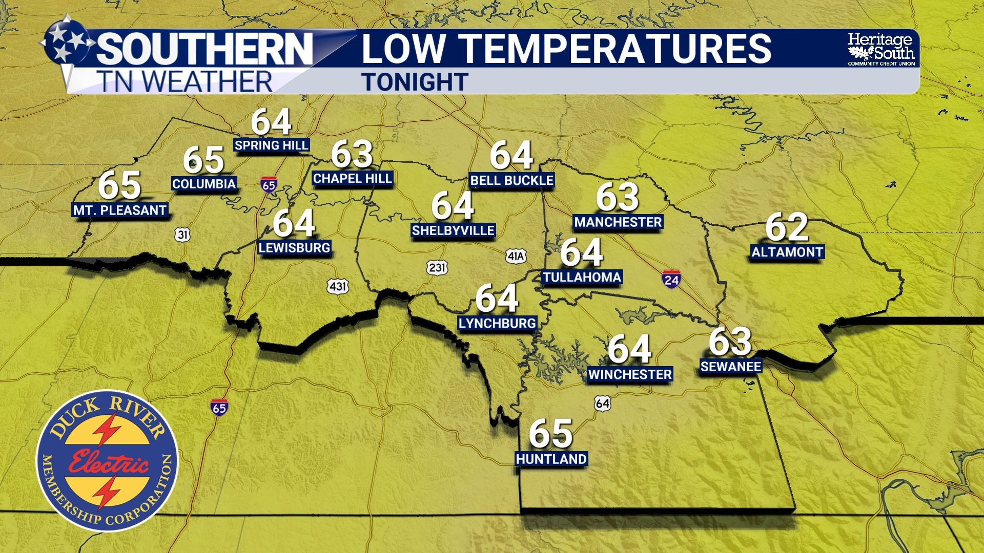
LOW TEMPS - TONIGHT
What’s Driving Saturday’s Rain
The setup for Saturday is much more organized compared to what we’ve seen lately… A developing system over the Plains will track toward the Midwest, dragging a cold front eastward toward the Tennessee Valley. Unlike the weak boundaries earlier this week, this front has enough support from the upper levels of the atmosphere to hold together as it moves into our area.
Ahead of the front, temperatures will once again climb into the lower 80s. That heating will help generate modest instability, with CAPE values around 1000 J/kg. That is enough for thunderstorms, but not overly impressive for this time of year. Wind shear also remains on the lower side, generally under 30 knots. That limits storm organization and is a big reason why the severe threat stays low.
Why Severe Weather Is Limited
Even though we will have a line of showers and storms moving through Saturday afternoon and evening, several key ingredients are lacking for a significant severe weather event. The strongest upper-level dynamics and jet stream energy remain well to our north, closer to the Great Lakes and Ohio Valley. That keeps the most favorable environment for severe storms away from our area.
Closer to home, the atmosphere will support thunderstorms, but mostly of the “garden variety” type. A few stronger wind gusts are possible, especially west of I-65 where instability is a bit higher and low-level lapse rates are steeper. That is tied to higher DCAPE values, which can enhance downburst potential. But overall, this is not a setup that supports widespread severe weather. That messaging has remained consistent, and there are no signs of that changing. The Storm Prediction Center has introduced our western zones in a MARGINAL risk (level 1/5) for severe thunderstorms tomorrow evening, but as I stated above, this does not change our forecast at all.
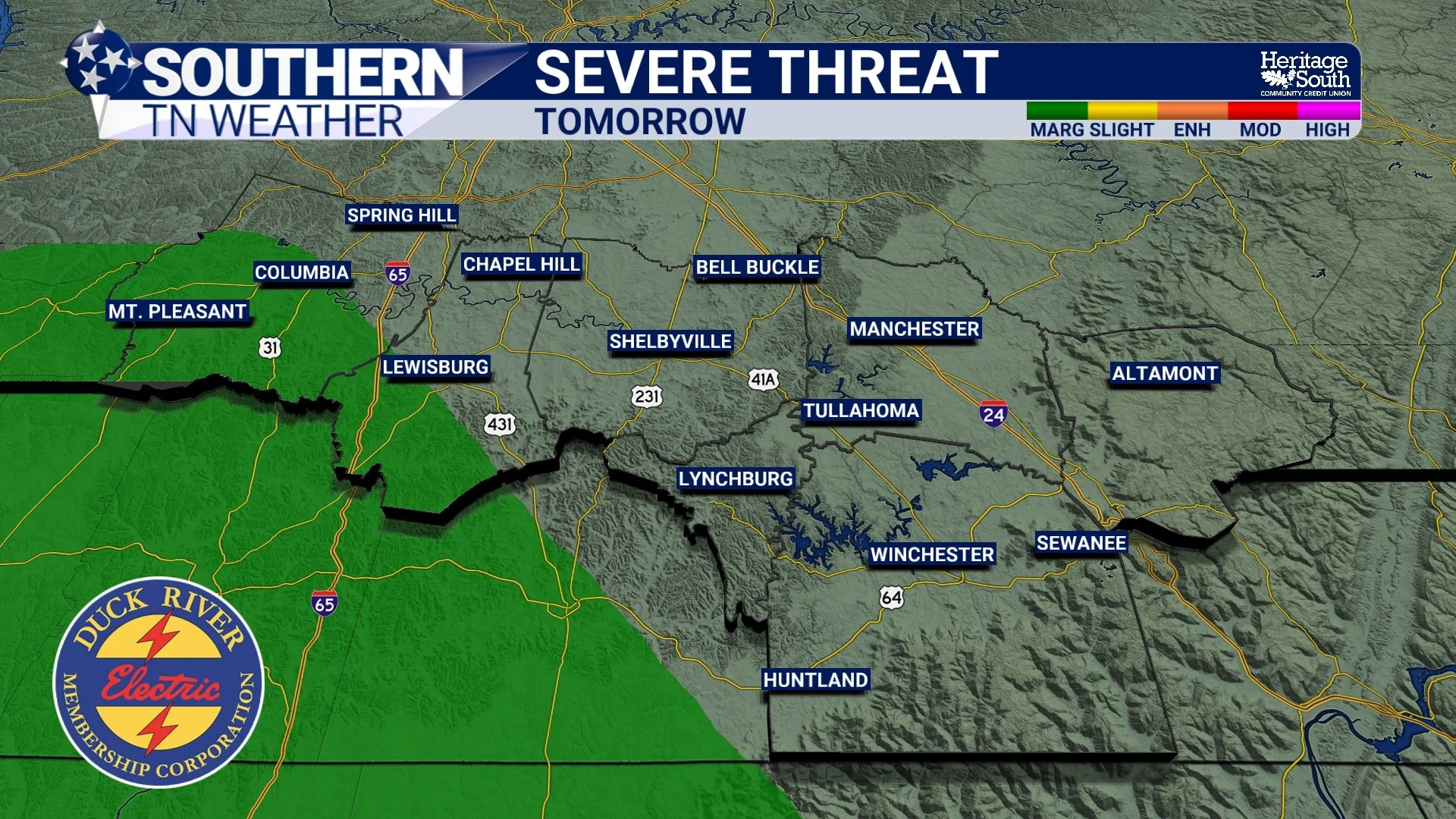
SEVERE THREAT - TOMORROW
Timing and Rainfall
Rain chances will increase through the day Saturday, with the highest coverage expected during the afternoon and evening hours as the cold front moves through. Generally between 4 PM and 10 PM. Showers and storms will continue into Saturday night, gradually moving from west to east. Rainfall totals generally between 0.5 and 1 inch look likely across much of Southern Middle Tennessee. Some localized areas could see a bit more, but overall this is shaping up to be a beneficial soaking rain rather than a flooding concern.
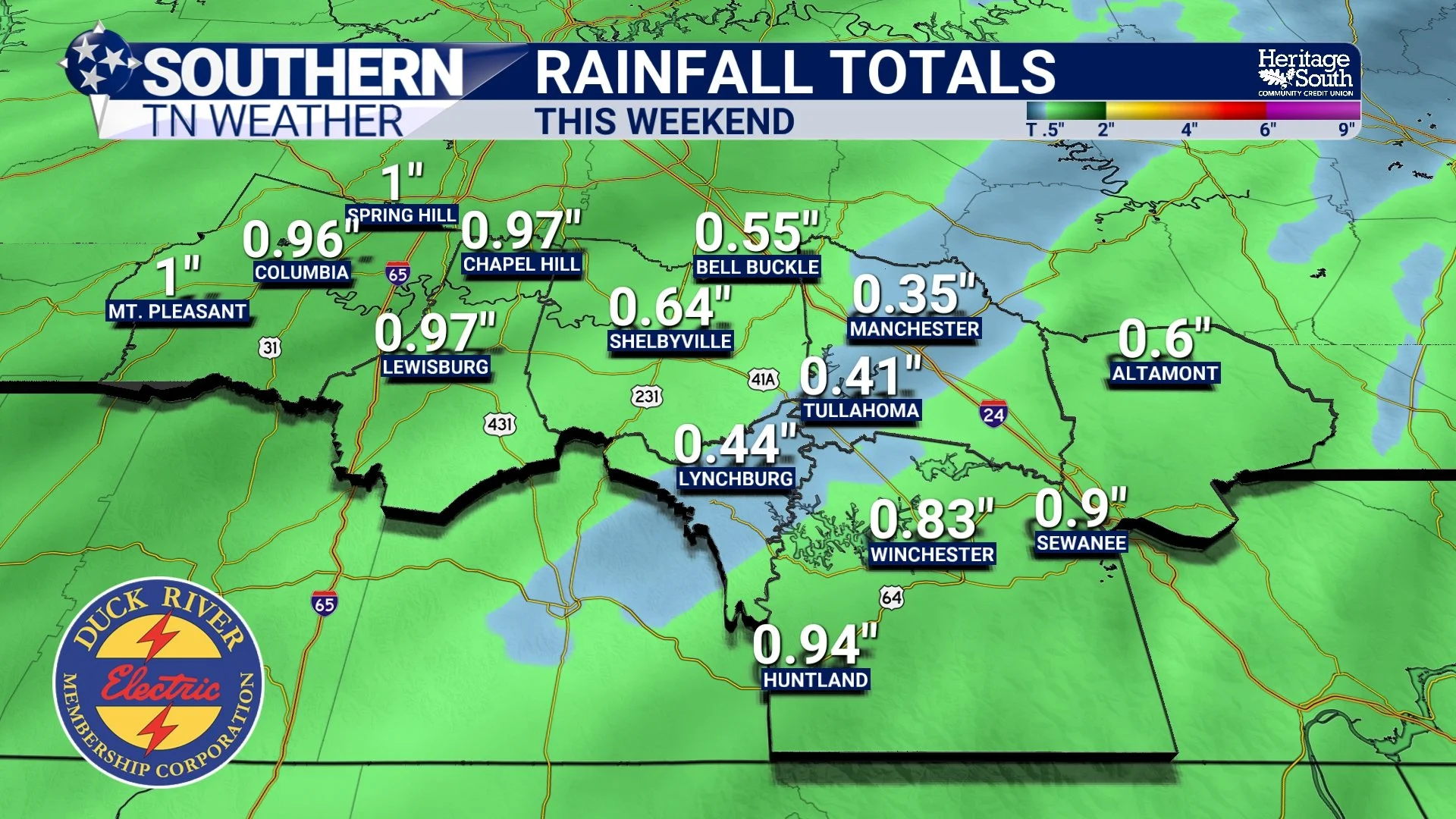
RAINFALL TOTALS - THIS WEEKEND
Easter Sunday: A Different Feel
By the time we wake up Easter morning, most of the rain will be moving out. A few lingering showers may hang on early, especially toward the Cumberland Plateau, but the trend will be toward drier conditions through the day.
The bigger story will be the temperature change. Winds will shift out of the northwest, bringing in a cooler and drier air mass. Highs will only reach the 60s, which will feel noticeably cooler compared to the 80s we’ve had recently. It will feel much more like a typical early April day…
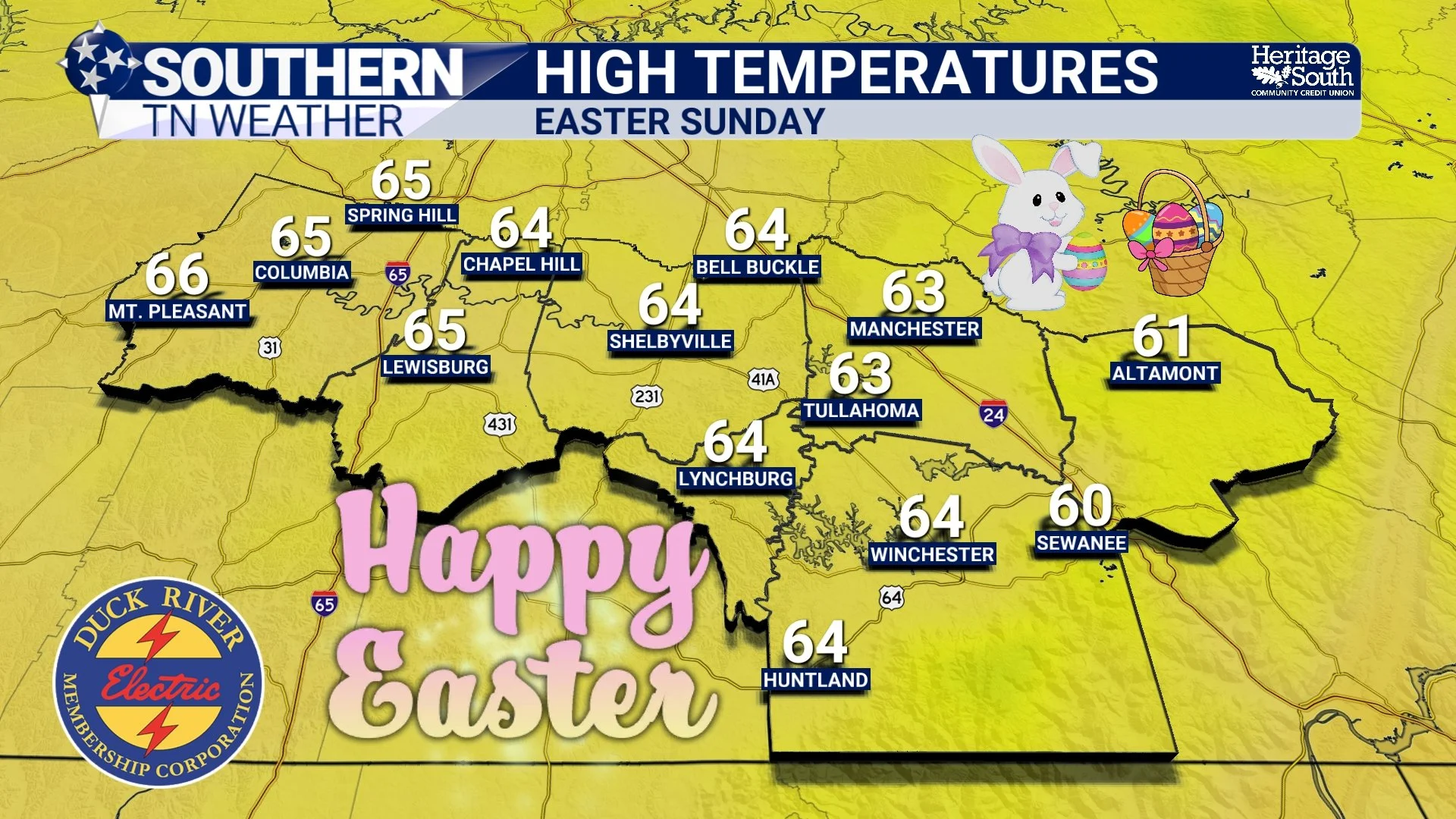
HIGH TEMPERATURES - EASTER SUNDAY
Looking Ahead
The cooler pattern will stick around into early next week, with highs in the 60s and 70s and overnight lows dropping into the 40s. Some of the colder spots could even dip into the upper 30s, so it is not quite time to fully commit to spring just yet. The overall pattern looks dry again after this weekend, meaning Saturday’s rain will be important.
The Bottom Line 🧾
• Warm and breezy conditions continue through Friday with highs in the 80s
• Showers and storms develop Saturday afternoon and evening
• Severe weather risk remains LOW, with only a few gusty storms possible
• Rainfall totals around 0.5 to 1 inch will provide beneficial rainfall
• Rain exits early Sunday with cooler, drier air moving in
• Easter Sunday will be cooler with highs in the 60s
📰 Reminder: The Southern Tennessee Weather Blog, presented by Heritage South Community Credit Union, is updated Monday through Friday with fresh, locally tailored forecasts you can trust.