
Drying Out On Friday, But Rain Returns On Sunday

The Southern Tennessee Weather Blog is proudly presented by Heritage South Community Credit Union.
We Help When Others Won’t!
Visit https://www.heritagesouth.org/ today to see how HSCCU can help YOU!
It's been a busy weather day across Southern Middle Tennessee, but thankfully, some of the concern from earlier forecasts has begun to ease. Showers and thunderstorms have blossomed across the region this afternoon as tropical moisture associated with the remnants of Arthur interacts with an approaching cold front. The atmosphere remains loaded with moisture, and scattered heavy downpours will continue to be possible through the evening hours.
The good news? The severe weather threat has diminished. In fact, the Storm Prediction Center has removed Southern Middle Tennessee from the severe weather outlook for the remainder of today. While an occasional gusty storm can't be completely ruled out, widespread severe weather is no longer expected. That doesn't mean we're completely out of the woods just yet.
Heavy Rain Remains The Main Concern
While severe weather concerns have decreased, heavy rainfall continues to be the primary impact this afternoon and evening. Meteorologists measure atmospheric moisture using something called precipitable water, or PWAT. Today, values across the area are running above two inches, meaning the atmosphere is capable of producing very efficient rainfall.
In simpler terms, if you get underneath one of the heavier storms, rainfall rates could be impressive. Localized minor flooding remains possible, especially in poor drainage areas and places where storms repeatedly move over the same location. Thankfully, widespread flooding is not expected. As the cold front gradually pushes southeastward later this evening, showers and thunderstorms should begin winding down from northwest to southeast.
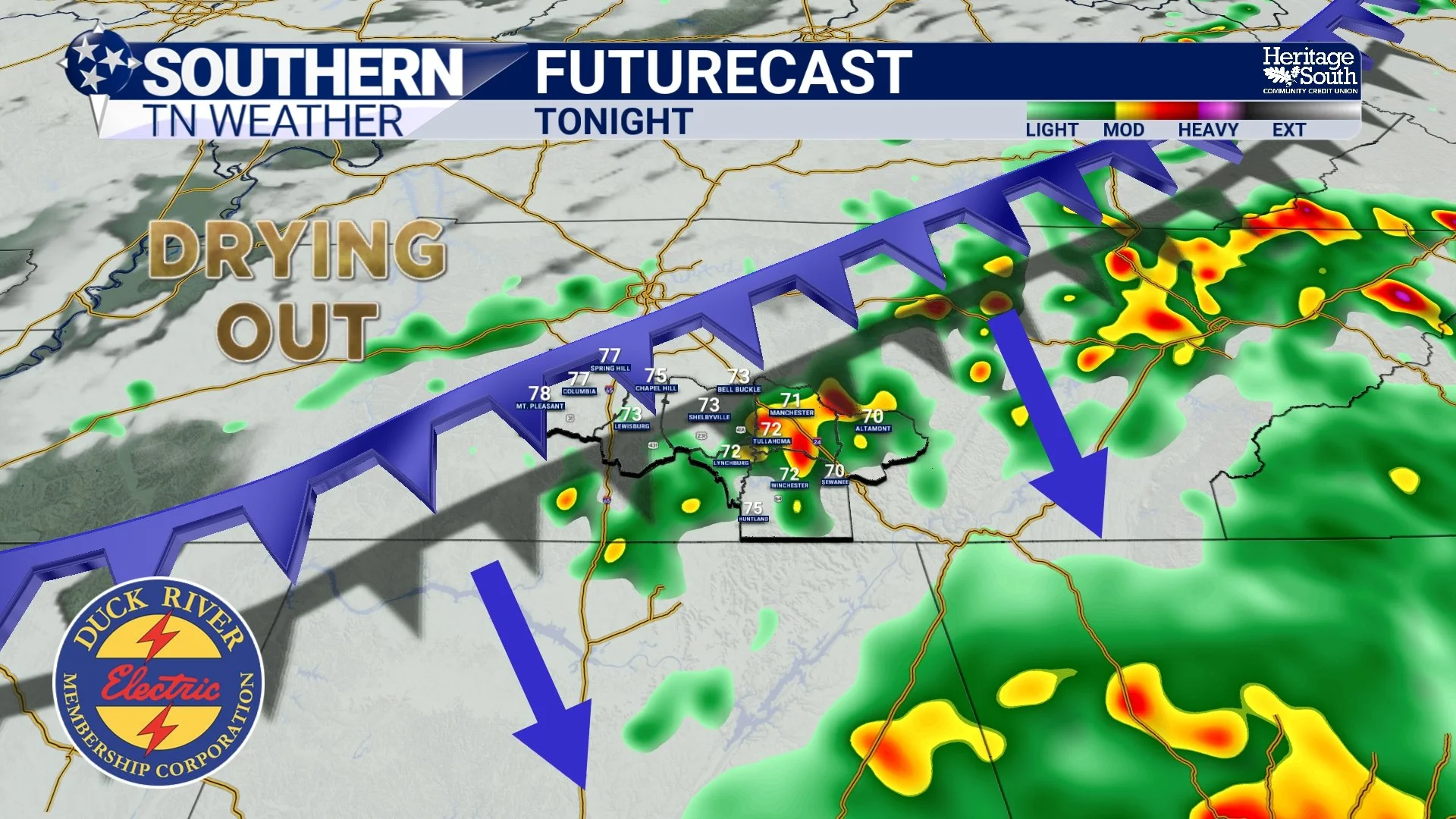
FUTURECAST - TONIGHT
Friday Brings A Break
After the active weather we've dealt with over the past couple of days, Friday should feel like a reward. The cold front responsible for today's storms will continue moving south of the area overnight, allowing drier air to work into Southern Middle Tennessee.
Most locations should stay dry Friday with highs in the lower to middle 80s. Humidity levels will also back off a bit compared to today, making for a fairly pleasant late June afternoon. Friday night looks even better, with partly cloudy skies and overnight lows settling back into the 60s.

HIGH TEMPERATURES - TOMORROW
Saturday Continues The Quiet Pattern
The quiet weather doesn't stop on Friday. Saturday is shaping up to be another nice day across the region with a mix of sun and clouds and temperatures climbing into the middle 80s. Humidity will slowly begin increasing again, but for anyone needing to mow the yard, head to the lake, or tackle outdoor projects that were postponed by today's rain, Saturday currently looks like the better opportunity.
Sunday Changes Things Again
Unfortunately, the quiet weather won't stick around for very long. Another disturbance developing over the Plains will move toward Tennessee during the second half of the weekend, bringing increasing chances for showers and thunderstorms. At this point, Sunday into Monday appears to be the next active stretch of weather.
Rain chances climb above 70 percent, and while widespread severe weather isn't currently expected, a few gusty storms can't be ruled out. Heavy rainfall could once again become a concern. The atmosphere will remain quite moist, and any thunderstorms that develop should be efficient rainfall producers. It's too early to pinpoint exact rainfall totals or impacts, but if you have Father's Day plans outdoors, you'll want to keep checking the forecast over the next couple of days.
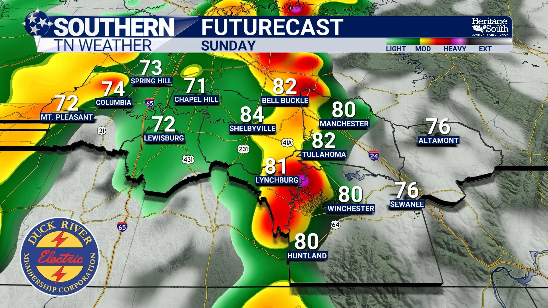
FUTURECAST - SUNDAY
Next Week Stays Active
Looking beyond the weekend, the overall weather pattern doesn't change very much. Southern Middle Tennessee will remain in a warm, humid summertime pattern with periodic chances for showers and thunderstorms throughout next week.
The better chances currently appear to be Sunday and Monday before rain coverage gradually decreases during the middle of the week. Even then, typical afternoon pop-up storms will remain possible. Temperatures should generally stay in the middle to upper 80s with overnight lows around 70 degrees.
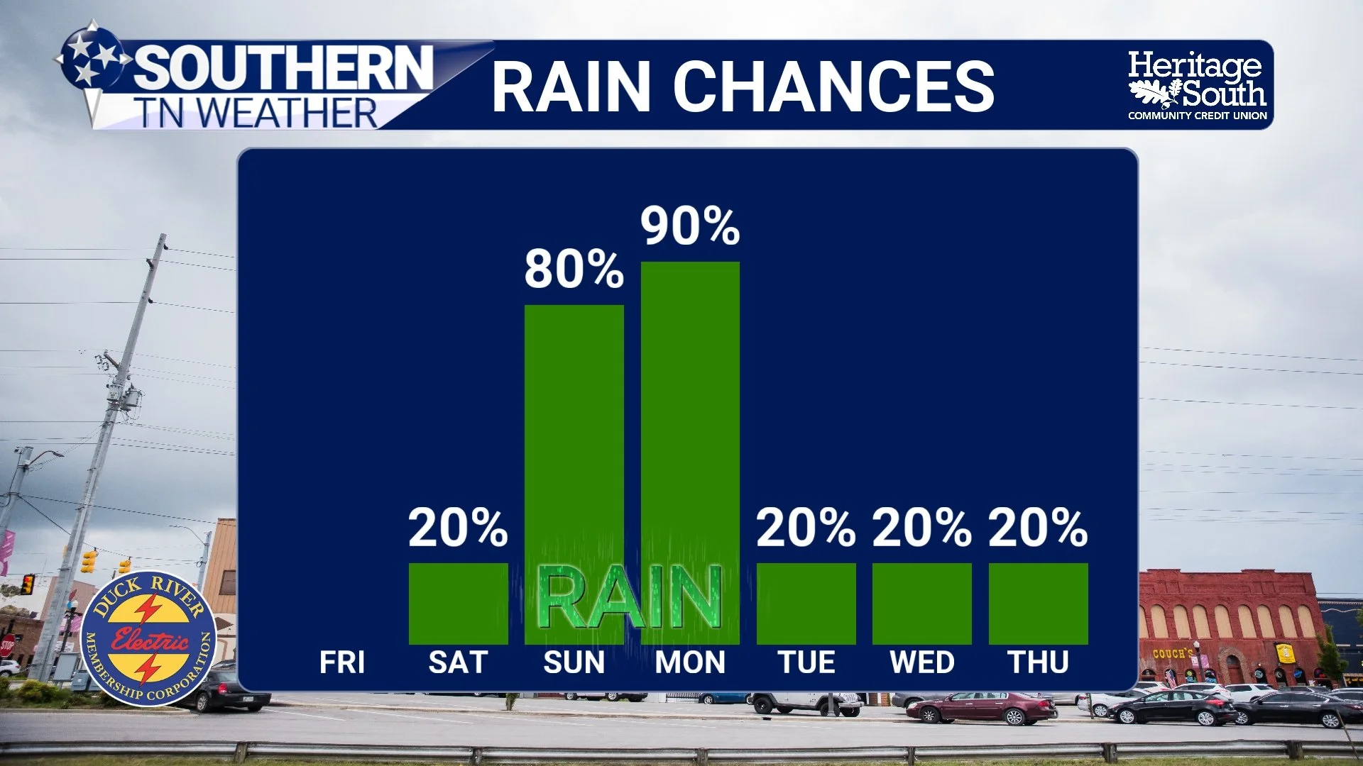
RAIN CHANCES - NEXT 7 DAYS
Looking Ahead
Today's storms are another good reminder that not every active weather day turns into a severe weather event. The atmosphere certainly contained plenty of moisture, but the ingredients simply didn't come together for widespread severe storms across our area. Instead, heavy rainfall has become the primary concern. The bigger picture over the next several days is fairly straightforward.
Get through today's rain. Enjoy a nice Friday and Saturday. Then prepare for another round of showers and thunderstorms Sunday into Monday.
The Bottom Line 🧾
Showers and thunderstorms continue through this evening.
The severe weather threat has ended for Southern Middle Tennessee.
Heavy rainfall and localized minor flooding remain possible today.
Dry weather returns Friday and continues through much of Saturday.
Sunday into Monday brings another round of widespread shower and thunderstorm chances.
Heavy rainfall may once again become a concern.
Warm and humid summertime weather continues through next week with periodic rain chances.
📰 Reminder: The Southern Tennessee Weather Blog, presented by Heritage South Community Credit Union, is updated Monday through Friday with fresh, locally tailored forecasts you can trust.