
Cold, Weak Disturbances, and a Hard Pill to Swallow for Snow Fans

The Southern Tennessee Weather Blog is proudly presented by Heritage South Community Credit Union.
We Help When Others Won’t!
Visit https://www.heritagesouth.org/ today to see how HSCCU can help YOU!
Today (Thursday): Flurries Ending, Cold Air Takes Over
Light flurries and spotty snow showers that moved across parts of Southern Middle Tennessee this morning have largely come to an end. These developed as very cold air poured in behind yesterday’s cold front and passed over a shallow layer of lingering low-level moisture. Atmospheric moisture is extremely limited today, which is why no accumulation was seen locally and overall impacts have remained low. Outside of the Cumberland Plateau, no additional wintry precipitation is expected. Even on the Plateau, any minor dustings that occurred earlier should remain brief and localized.
Despite a few breaks in the clouds this afternoon, cold air advection remains strong. Northwest winds continue to funnel colder air into the region, keeping temperatures suppressed and wind chills uncomfortable. Highs will struggle to reach the mid-30s, and it will feel colder than that much of the day.
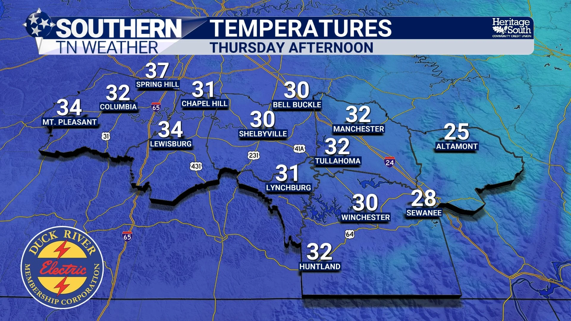
Temperatures - Thursday Afternoon
Friday into Early Saturday: Another Weak System, Limited Impacts
As surface high pressure slides east tonight, low-level winds will gradually turn back to the south. This return flow will allow moisture to increase aloft and bring clouds back into the region late tonight and Friday. By Friday afternoon, a weak disturbance and approaching cold front will introduce another round of light precipitation. Showers are most likely Friday afternoon and evening, especially across areas east of I-65. Timing looks to be between 2 PM and 7 PM. As colder air arrives behind the front Friday night, rain may briefly mix with or change to snow.
However, this system remains moisture-starved, and the overlap between moisture and cold air appears short-lived. For most of Southern Middle Tennessee, this points toward little to no accumulation and very little flakeage. The Cumberland Plateau continues to be the one area where cold air and lingering moisture could overlap long enough to support light accumulation, generally under a half inch. Speaking of under a half inch, rainfall totals with this system will stay well under a half inch.
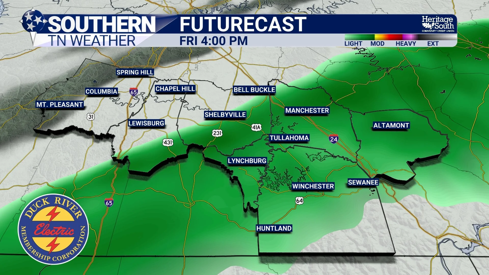
Futurecast - Friday Afternoon
Beyond That: The Pattern Becomes the Story
Once Friday night’s weak system exits, the broader atmospheric pattern takes control. A longwave trough will remain anchored across much of the central and eastern United States, meaning the cold air now in place will not be quickly replaced.
Instead, Southern Middle Tennessee settles into a reinforcing winter regime. Periodic weak disturbances may bring clouds, flurries, or brief light precipitation, but the dominant signal is persistent cold. Highs will frequently remain in the 30s and lower 40s, while nighttime lows drop into the teens and 20s. The coldest stretch currently looks to arrive late Sunday through early Tuesday. Tuesday morning looks to be the coldest of the next 7 days, when low temperatures in the low teens and single digits will be possible.
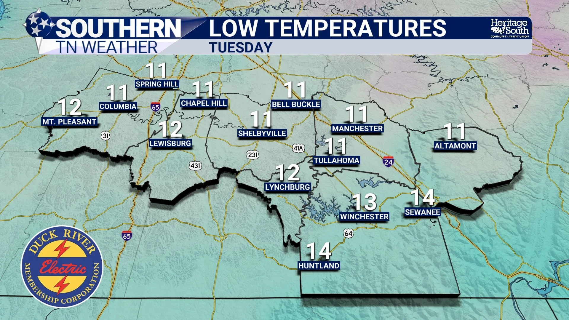
Forecast Low Temperatures - Tuesday Morning
A Hard Pill to Swallow for Snow Lovers
Over the past couple of weeks, I’ve talked about how this evolving pattern is favorable for wintry weather in the South. And as we move deeper into it, that idea is proving true. Almost too true… Let me explain.
The latest runs of our most trusted global models are increasingly advertising a light to moderate snow event this weekend across portions of the Deep South — including southern Alabama, the Florida Panhandle, and southern Georgia. Meanwhile, Southern Middle Tennessee currently sits just north of the most favorable moisture corridor. This is a classic suppressed-track winter setup. Strong high pressure builds over our region, locking cold air in place. At the same time, the upper-level trough becomes tilted in a way that favors rising motion along the Gulf and Atlantic coasts. The result is that lift and moisture focus south of Tennessee. In simple terms: the cold is here, the pattern is right, but the precipitation is being forced south.
It’s frustrating, especially when snow is falling in places that normally never see it. The good news is that February is historically our snowiest month, and some of our most memorable events have even happened in March. Winter is not done. It may simply take another round or two for the pieces to align directly over us.
So yes… there may very well be places well south of us that see measurable snow before we do this winter. Yikes.
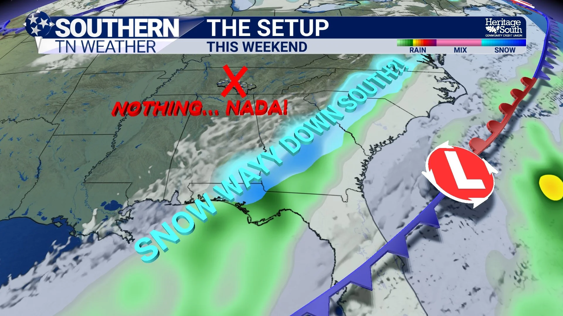
The Setup - This Weekend
The Bottom Line 🧾
• Bitter cold remains locked in
• Another weak system brings light rain Friday with a brief rain/snow mix possible Friday night
• Light Plateau accumulations will be possible
• The dominant story becomes prolonged cold
• A weekend snow signal is increasing across the Deep South (likely south of us)
📰 Reminder: The Southern Tennessee Weather Blog (Presented by Heritage South Community Credit Union) is updated Monday through Friday with fresh, locally tailored forecasts you can trust.