
Quick-Hitting, Cold Rain Tonight

The Southern Tennessee Weather Blog is proudly presented by Heritage South Community Credit Union.
We Help When Others Won’t!
Visit https://www.heritagesouth.org/ today to see how HSCCU can help YOU!
A Cloudy and Cold Monday…
Today marks the first day of meteorological winter, and winter is certainly making her presence known. Lows were in the 20s this morning, and as of mid-afternoon, temperatures are still stuck in the low 40s—perfect “stay inside and cuddle up” weather. A light south breeze late today will help moderate temps just enough before our next round of rainfall moves in this evening.
It’s Gonna Rain!
Every time I talk about rain, I think of that Family Guy “It’s gon’ rain!” GIF… and believe me, it applies tonight. A pretty healthy, soaking rain is on the way. We’re talking 0.5 to 1 inch of total rainfall for Southern Middle Tennessee.
Timing / Wintry Schenangians?
Rain arrives between 3 PM and 6 PM, then quickly becomes widespread. This will be a steady, continuous rain with very few breaks overnight. Showers taper from west to east by 6–8 AM Tuesday. Because temperatures remain well above freezing during the entire event, this will fall mostly as rain here locally. You can track the rain in our FREE Southern Tennessee Weather Mobile App or our 24/7 Weather Channel!
However, technically as moisture exits Tuesday morning, a few snowflakes or sleet pellets may mix in. No accumulation and no impacts are expected, though. The freezing line will set up within about 100 miles northwest of our area, and the Nashville NWS has issued a Winter Weather Advisory for far northwest Middle Tennessee — well outside the Southern Tennessee Weather coverage area. That’s where cooler air arrives early enough to bring some light ice/sleet/snow.
Let’s be clear and set some expectations, though:
There will NOT be impactful snow here tonight in Southern Middle Tennessee. TV stations in Nashville will talk about winter weather for THEIR viewing area, which includes Clarksville, Hopkinsville, Dover, and Bowling Green. Those places very well will see some flakes and even a glaze of ice or sleet.
But for us? Cold rain. Period. The freezing line just doesn’t make it this far southeast.
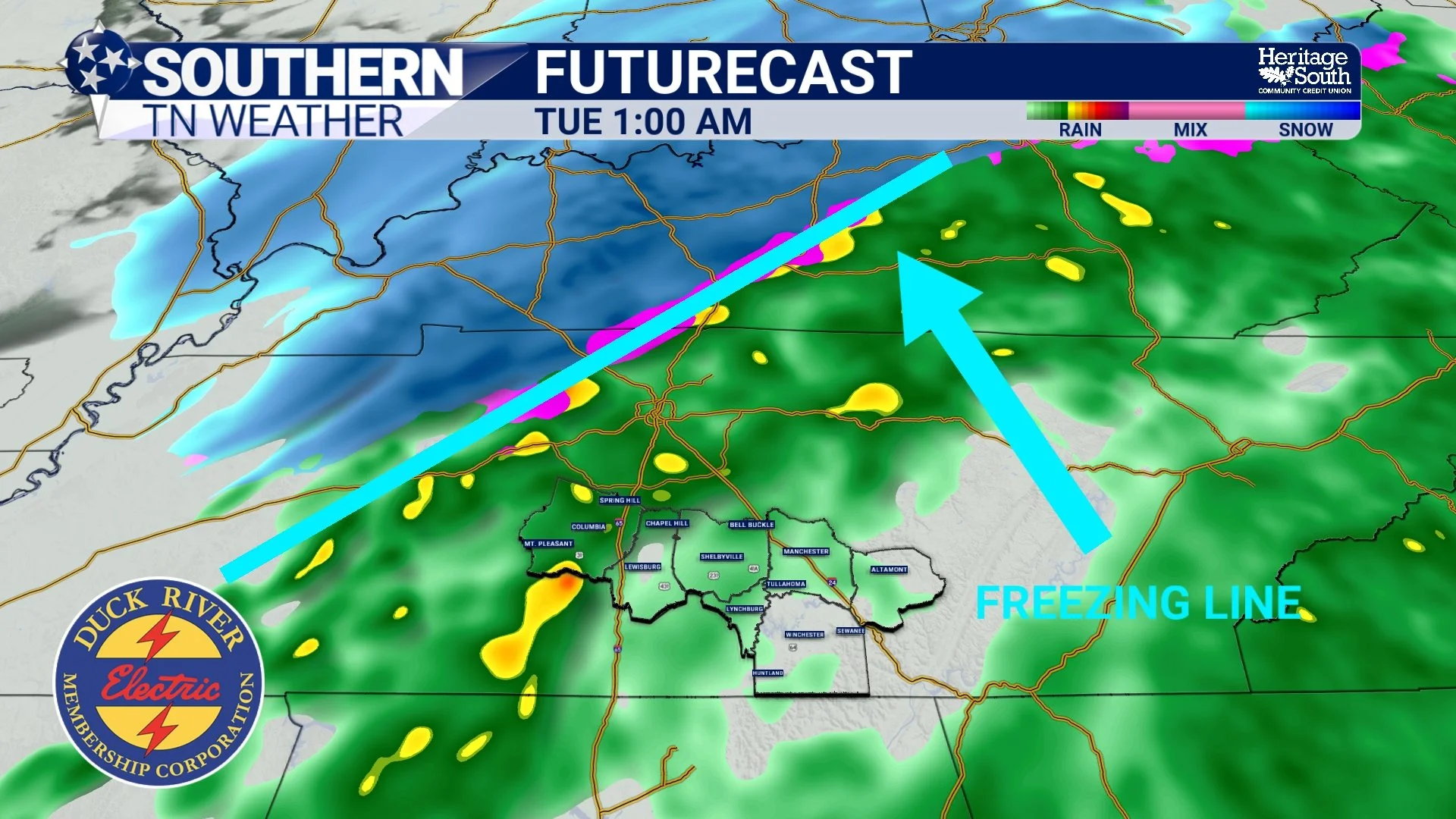
Freezing Line Setup Tonight
A Classic Setup… Just a Little Too Warm
It’s worth noting that tonight’s setup (a Gulf low with cold Canadian air trying to spill in) is exactly the pattern responsible for many of our biggest winter storms. If tonight’s event were happening in January or February, I think we’d be talking about snow, not rain. For snow lovers, this pattern is a good sign for the winter ahead.
If you missed my full deep-dive on Gulf Lows in Friday’s blog, you can read it here.
Tuesday: Bitter Cold Behind the Rain
Tomorrow is going to be downright cold. Even after the rain ends early, temperatures will struggle to recover. Highs only reach the upper 30s, and a brisk north wind will keep wind chill values below freezing all day. Even around lunchtime, wind chills may be in the mid 20s.
Cloud cover hangs around through much of Tuesday, so don’t expect any solar help. Bundle up if you’re heading out.
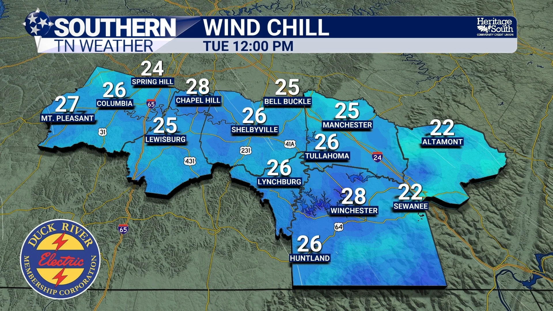
Wind Chills Tonight
The Week Ahead
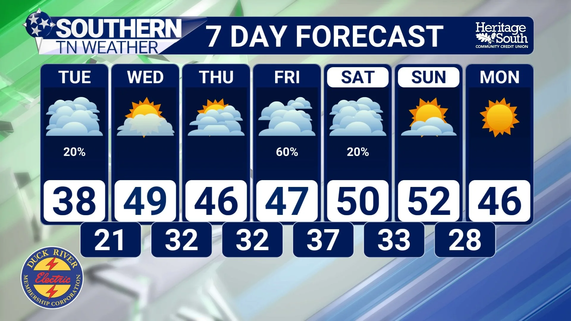
Once tonight’s system clears, we stay dry Wednesday with below-normal highs. Lows rebound slightly but remain chilly. Our next rain chance arrives Thursday night into Friday, but early signs show limited moisture and low impact. Saturday looks mostly dry, especially the afternoon and evening (at least so far). This is good news for the many outdoor Christmas events locally. I’ll monitor trends closely as we get closer.
The Bottom Line 🧾
• Widespread rain arrives between 3–6 PM and lasts through early Tuesday
• 0.5–1 inch of rain expected — a cold, steady soaking
• A few flakes / sleet pellets may mix in Tuesday morning, but no impacts expected locally
• Tuesday stays very cold, with highs in the upper 30s and wind chills in the 20s
• Midweek turns dry and chilly; next rain chance arrives Thursday night–Friday
• Weekend currently looks decent, especially Saturday afternoon and evening
📰 Reminder: The Southern Tennessee Weather Blog (Presented by Heritage South Community Credit Union) is updated Monday through Friday with fresh, locally tailored forecasts you can trust.