
Calm Now, Warmer Ahead: A Quiet New Year’s Eve Across Southern Middle Tennessee

The Southern Tennessee Weather Blog is proudly presented by Heritage South Community Credit Union.
We Help When Others Won’t!
Visit https://www.heritagesouth.org/ today to see how HSCCU can help YOU!
Southern Middle Tennessee is closing out 2025 on a calm and noticeably milder note. After the colder air earlier this week, temperatures are rebounding today as the overall weather pattern settles into something much quieter. For New Year’s Eve, conditions are cooperative, calm, and seasonably mild — a welcome break after the recent cold snap.
This is one of those “in-between” weather days. Nothing disruptive. Nothing dramatic. Just a slow transition toward a warmer pattern that will carry us into the start of 2026.
a Calm New Year’s Eve
This afternoon, temperatures are climbing through the 40s and into the lower 50s across much of Southern Middle Tennessee. Skies are partly cloudy with filtered sunshine at times, and winds remain light, making it feel noticeably more comfortable than earlier in the week. As we move into the evening and overnight hours, temperatures will settle just below freezing for most areas. Even so, conditions will remain calm and dry. If you’re heading out to ring in the New Year, weather won’t be a concern! Just a cool, quiet night overall.
This calm stretch is the result of weakening frontal boundaries nearby and a broad area of high pressure gradually building into the region. It’s a classic winter lull in the pattern.
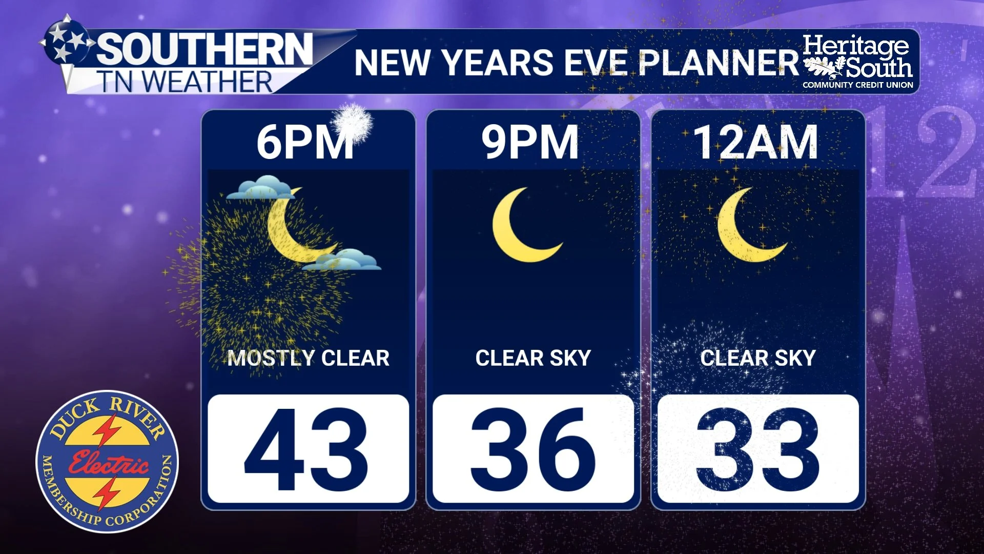
NYE Forecast
New Year’s Day Brings a Warm-Up
Thursday marks the beginning of a noticeable warming trend. As winds turn more westerly and southwesterly, temperatures will climb into the mid to upper 50s across much of Southern Middle Tennessee. A few spots could even flirt with 60 degrees during the afternoon.
Skies will feature a mix of clouds and filtered sunshine, but overall, it will be a pleasant and mild start to 2026. For late December and early January, this is well above average and will feel more like early spring than winter.
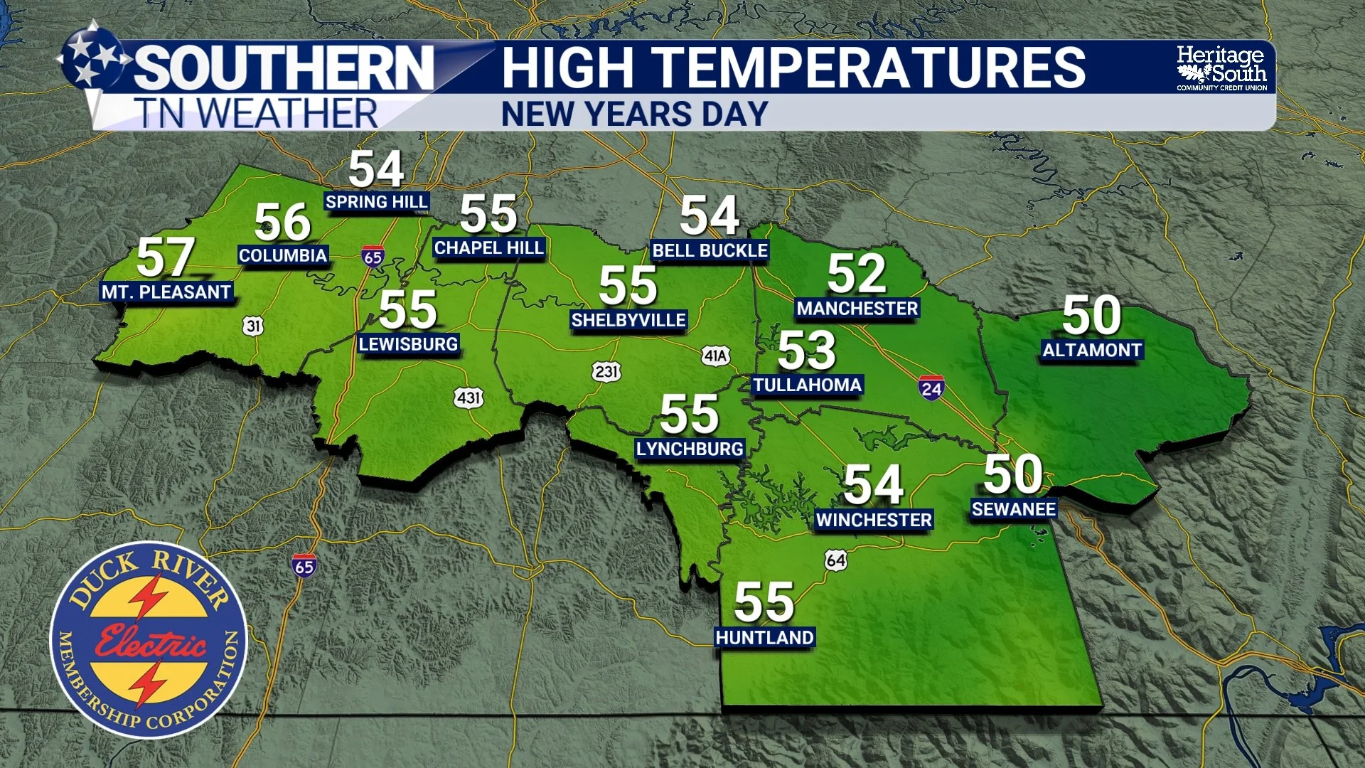
High Temperatures - New year’s Day
Rain Returns Late Friday Into Early Saturday
Our next weather system arrives late Friday into early Saturday as a low-pressure system moves east from the southern Plains into the Tennessee Valley. This will bring increasing clouds followed by a period of rain.
Current guidance suggests most of Southern Middle Tennessee will receive between 0.25 and 0.75 inches of rainfall, though newer model runs are trending slightly wetter. Some guidance, including the latest GFS, shows localized totals approaching one inch. While this system does not appear to be severe, a few rumbles of thunder can’t be completely ruled out late Friday night, especially across southern portions of the area. Overall, this looks like a beneficial soaking rain rather than a disruptive weather event.
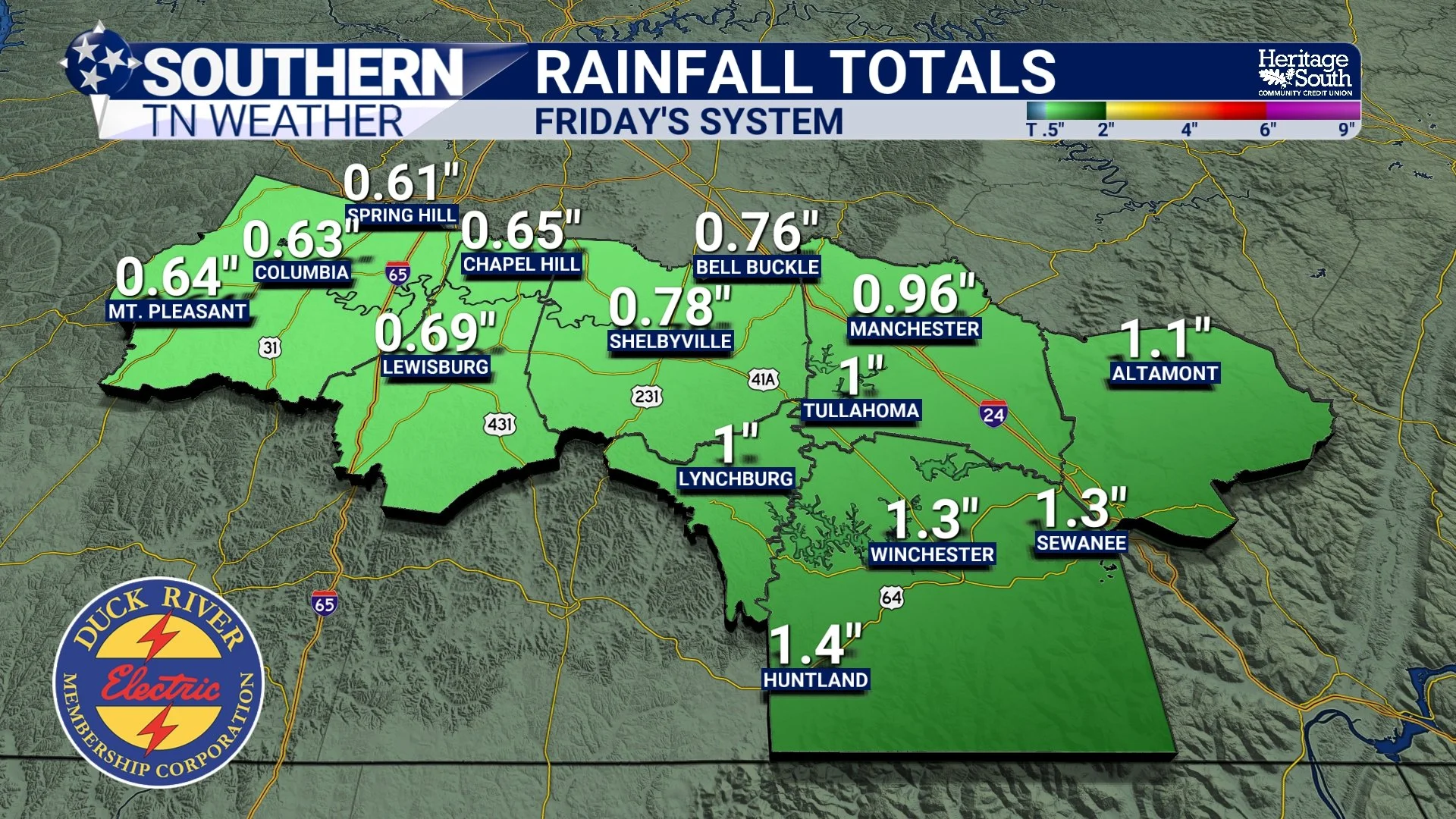
GFS Rainfall Totals - Friday
Looking Ahead Into Early Next Week
Behind this system, temperatures cool slightly but remain near seasonal levels. Highs will generally stay in the 50s with dry weather returning Sunday and continuing into early next week. Overall, the pattern remains calm, manageable, and fairly mild as we step into the first full week of 2026. I am watching a wetter pattern which may break out late next week, but we’re still fairly far out.
The Bottom Line 🧾
• Rain returns late Friday into early Saturday, with generally light to moderate totals expected.
• No severe weather is anticipated with this system.
• Temperatures cool slightly this weekend, but remain seasonable with dry weather returning early next week.
📰 Reminder: The Southern Tennessee Weather Blog (Presented by Heritage South Community Credit Union) is updated Monday through Friday with fresh, locally tailored forecasts you can trust.