
The Atmosphere Is Flipping the Summer Switch

The Southern Tennessee Weather Blog is proudly presented by Heritage South Community Credit Union.
We Help When Others Won’t!
Visit https://www.heritagesouth.org/ today to see how HSCCU can help YOU!
If you enjoy cooler mornings and comfortable spring weather, enjoy the next 24 hours… because a major pattern change is underway across Southern Middle Tennessee. Over the next several days, temperatures are going to steadily climb as a large ridge of high pressure strengthens across the Southeast United States. By Sunday and early next week, many communities west of the Plateau will likely see highs surge into the lower 90s for the first time this year.
And unfortunately, meaningful rainfall still remains hard to find…
One More Cool Night Before the Warmup
A broad upper-level trough moving through the eastern United States has helped keep temperatures below normal the past few days. Dry air has filtered into the region, skies have remained mostly clear, and humidity levels have stayed very comfortable. Tonight will likely be one of the coolest nights we see for a while.
Many locations near and east of Interstate 65 will drop into the lower and middle 40s by early Friday morning. Some sheltered valleys may even flirt with the upper 30s briefly around sunrise. A little patchy fog will also be possible in the usual low-lying areas. By Friday afternoon though, the atmosphere begins shifting gears.
Winds will turn more southerly, temperatures will rebound into the upper 70s and lower 80s, and humidity levels will slowly begin recovering.
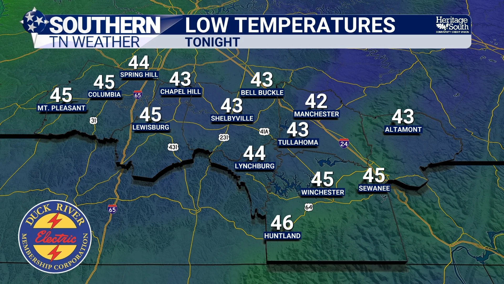
LOW TEMPERATURES - TOMORROW
Why Temperatures Are About to Spike
The main driver behind the upcoming heat is strengthening upper-level ridging across the Southeast. When meteorologists talk about a “ridge,” we’re referring to an area of higher atmospheric pressure aloft associated with warmer, sinking air. Sinking air suppresses widespread cloud development and rainfall while allowing temperatures to warm efficiently during the daytime hours. Forecast models show this ridge becoming increasingly amplified through the weekend and into early next week. In fact, some atmospheric height anomalies are projected to climb well above average for mid May. This setup favors several straight days of summer-like temperatures.
Saturday should feature highs mainly in the lower to middle 80s, while Sunday and Monday will likely become the hottest days of this stretch. Highs west of the Plateau may climb into the lower 90s both afternoons. The good news is that humidity levels, while increasing some, still do not appear excessively oppressive yet. This will feel more like an “early summer preview” rather than peak July misery.
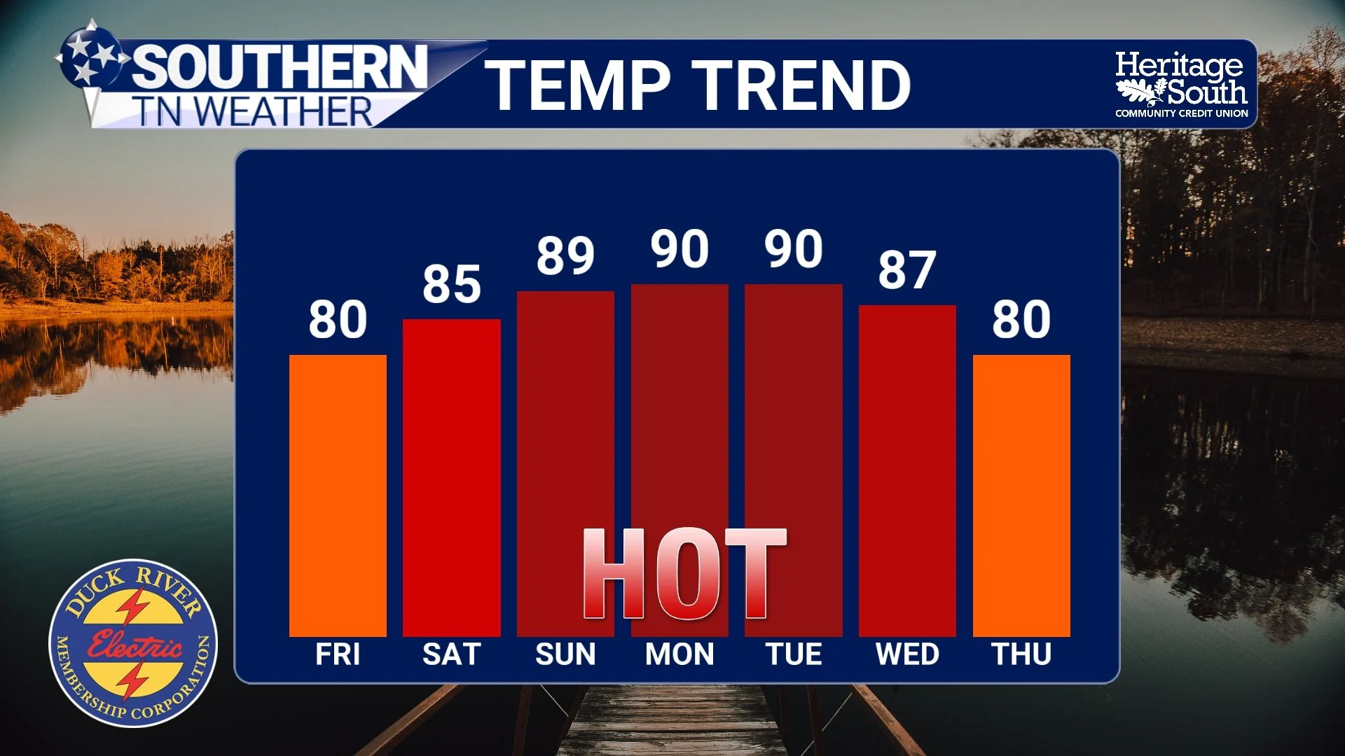
TEMPERATURE TREND
Rain Chances Continue Struggling
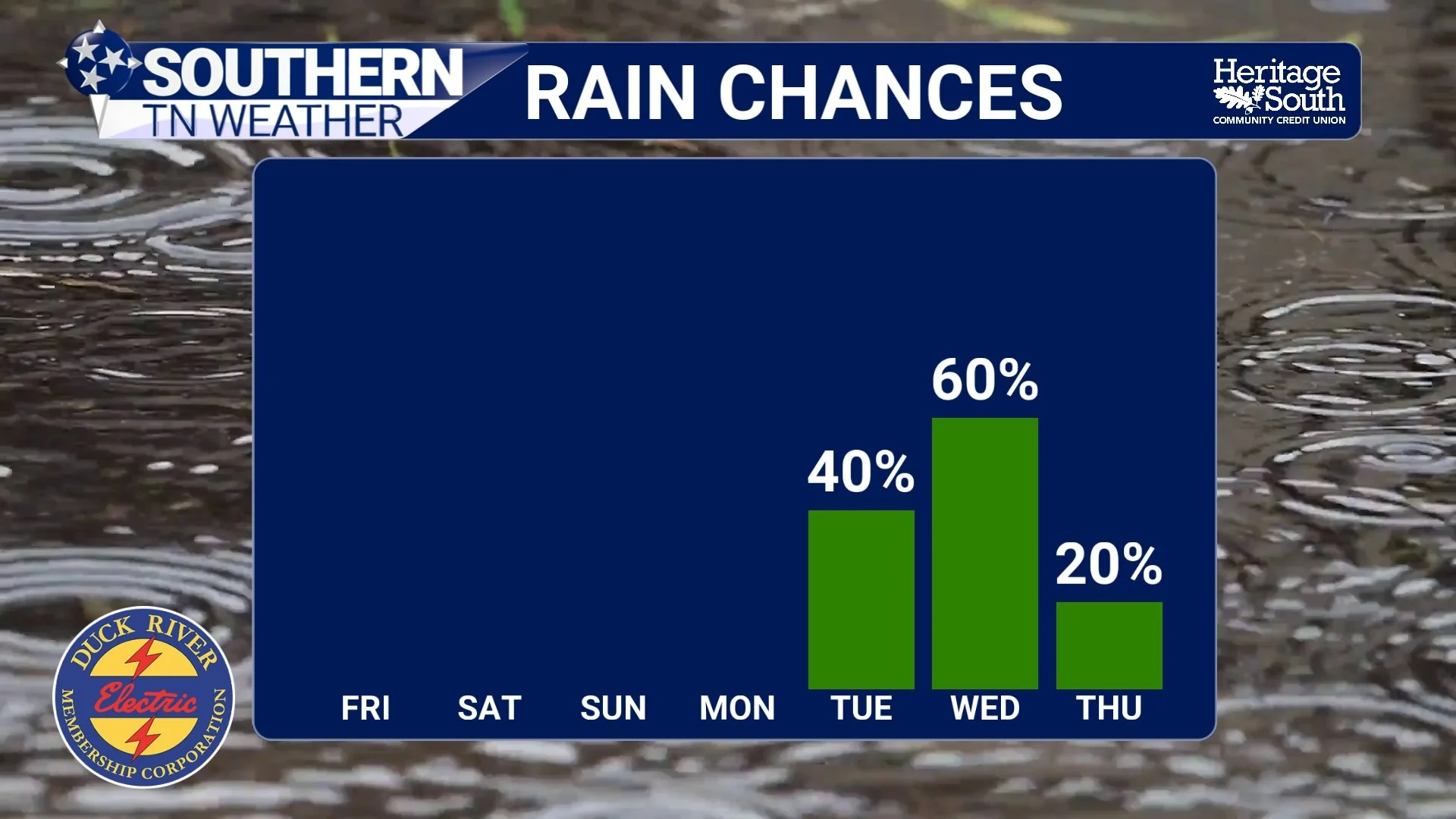
Now for the frustrating part of the forecast. Despite a few tiny rain chances appearing in forecast guidance, widespread soaking rainfall continues avoiding much of Middle Tennessee.
A weak disturbance may pass north of the area Saturday, and a stray shower or storm cannot be completely ruled out north of Interstate 40. However, most communities across Southern Middle Tennessee will remain dry through the weekend. The reason is fairly simple: the strengthening ridge is acting like a lid on the atmosphere. Rising air motions become suppressed underneath strong ridging, making it difficult for widespread shower and thunderstorm development to occur.
This is one reason droughts can become stubborn during summer-like patterns. Once strong ridging establishes itself, storm systems often get deflected northward around the ridge instead of moving directly through Tennessee. Forecast guidance does continue hinting at somewhat better rain and storm chances by the middle portion of next week as the ridge weakens and disturbances attempt to move in from the northwest. However, confidence on exact timing and coverage remains fairly low right now.
RAIN CHANCES
Fire Weather Concerns Continue
Another issue we continue monitoring is increasing fire danger. Dry vegetation, low humidity values, and occasional gusty winds continue creating marginal fire weather concerns across portions of the area. Even though conditions are not extreme, it still does not take much for fires to spread quickly this time of year when vegetation and soils remain dry.
Use caution with any outdoor burning.
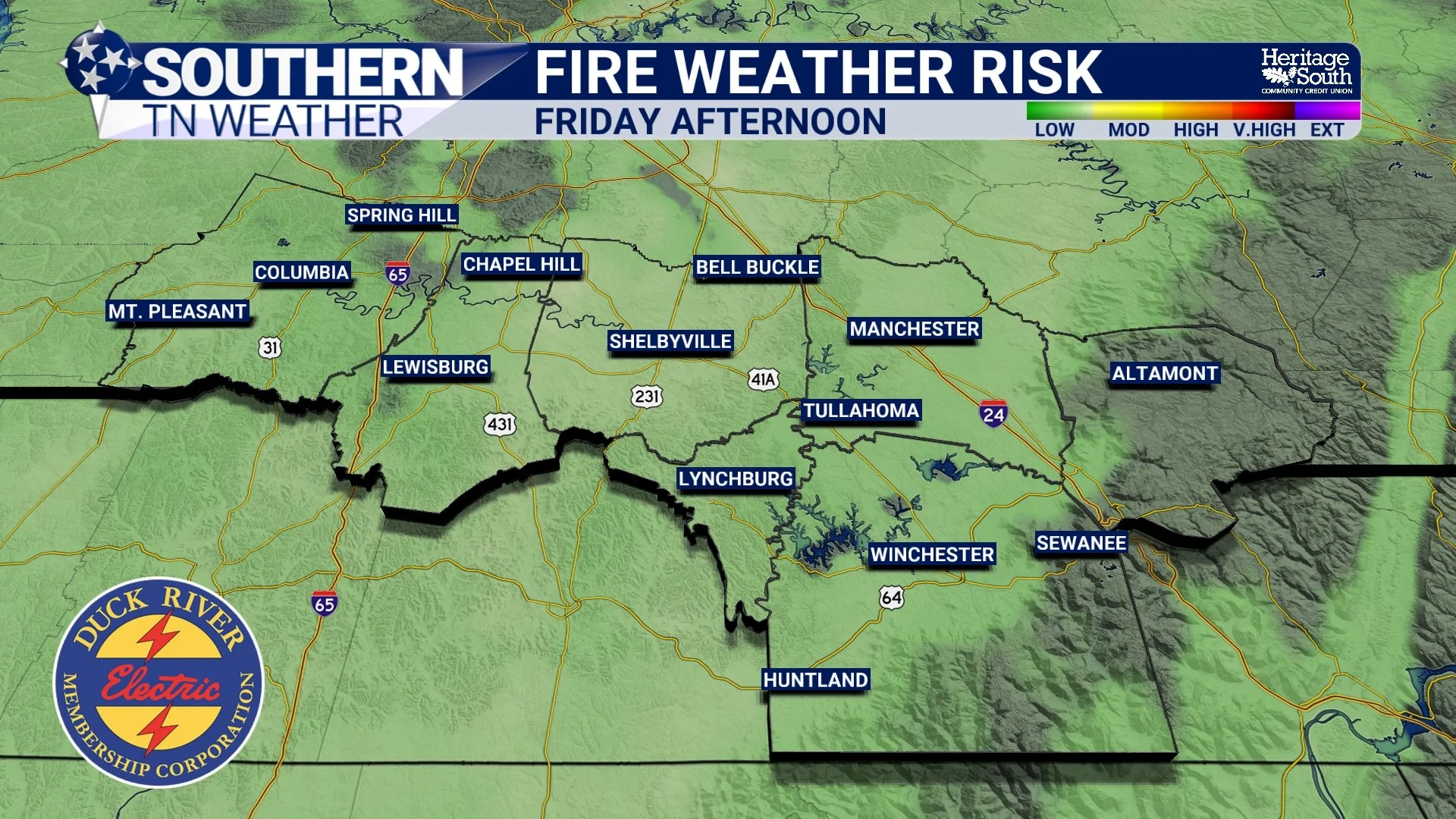
FIRE WEATHER RISK
The Bottom Line 🧾
Cool mornings continue through Friday with lows dropping into the 40s tonight.
Temperatures steadily warm this weekend with highs climbing into the 80s Saturday.
Lower 90s are likely west of the Plateau Sunday into early next week.
Humidity levels will increase some but should remain tolerable overall.
Only isolated rain chances exist this weekend, mainly north of I-40.
Drought conditions will likely continue worsening due to limited rainfall.
Better rain chances may finally arrive by the middle of next week.
📰 Reminder: The Southern Tennessee Weather Blog, presented by Heritage South Community Credit Union, is updated Monday through Friday with fresh, locally tailored forecasts you can trust.