
The Heat Is Building… But The Rainfall Isn’t

The Southern Tennessee Weather Blog is proudly presented by Heritage South Community Credit Union.
We Help When Others Won’t!
Visit https://www.heritagesouth.org/ today to see how HSCCU can help YOU!
The forecast over the next several days is going to feature two very different stories unfolding across Southern Middle Tennessee. First, we’ll continue enjoying several more days of absolutely beautiful spring weather with cool mornings, comfortable humidity, and highs mostly in the 70s and lower 80s. But second… the atmosphere is preparing to flip the switch toward an early taste of summer by this upcoming weekend.
Unfortunately, what we still are NOT seeing is meaningful rainfall.
One More Stretch of Comfortable Spring Weather
If you’ve stepped outside the past few mornings, you’ve probably noticed how nice the air has felt. Dewpoints have remained low, skies have been mostly sunny, and overnight temperatures have been dropping comfortably into the 50s. That pattern will continue through at least Thursday.
A weak cold front will slide through the region Wednesday into Wednesday night. Normally in May, cold fronts can trigger widespread showers and thunderstorms. This one simply does not have much moisture to work with. A few isolated showers or storms may develop mainly east of Interstate 65 Wednesday afternoon and evening, especially closer to the Cumberland Plateau. However, most communities across Southern Middle Tennessee will remain dry. Even the locations that do see rainfall will likely only pick up a few hundredths to maybe a tenth of an inch.
In meteorology, moisture is one of the key ingredients needed for widespread rainfall. Right now, the atmosphere simply remains too dry overall to support a meaningful rain event. Once the front passes, another shot of cooler and drier air arrives for Thursday. Highs will likely stay in the upper 60s and 70s with a refreshing north breeze. Thursday morning may actually feel more like late April than mid-May.
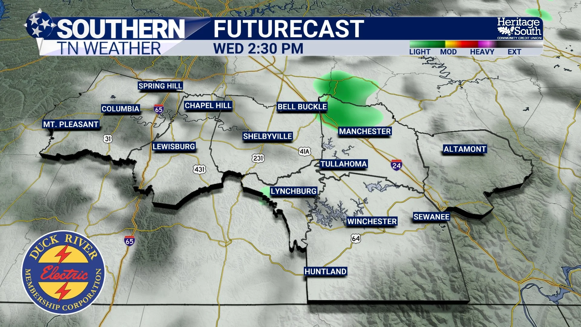
FUTURECAST - WEDNESDAY AFTERNOON
The Weekend Pattern Change
By Friday and especially this weekend, the larger-scale atmospheric pattern begins changing significantly. An upper-level ridge of high pressure will begin strengthening across the eastern half of the United States. When meteorologists talk about “ridging,” we’re referring to an area of warmer, sinking air aloft. Sinking air suppresses cloud development and rainfall while allowing temperatures to climb efficiently. Forecast guidance shows 500mb heights climbing well above average this weekend. That’s one of the classic signatures of a building summer-like pattern.
What does that mean for us locally? Hotter afternoons. High temperatures will likely climb well into the upper 80s this weekend, with several locations potentially reaching the lower 90s for the first time this year by Sunday and early next week. The good news is that humidity levels still do not appear excessively high. So while afternoons will feel hot, it should not feel oppressively muggy quite yet. Think “early summer” instead of “deep July misery.”
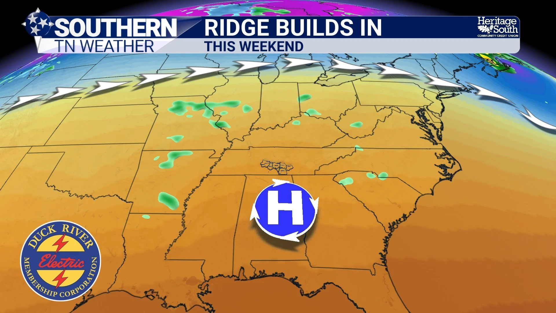
RIDGE BUILDS IN - THIS WEEKEND
Why the Drought Continues
Now for the frustrating part… Despite occasional tiny rain chances showing up in forecast models, widespread soaking rainfall continues avoiding much of Tennessee. The atmosphere simply lacks a strong mechanism capable of producing organized rainfall across the region.
Drought conditions across Southern Middle Tennessee are likely to worsen over the next 7 days. Streams, ponds, and soil moisture levels will continue slowly declining unless we can somehow luck into isolated heavier showers. The frustrating reality about droughts is that they often become self-reinforcing. Dry soils can make it harder for the atmosphere to efficiently recycle moisture back upward through evaporation and plant transpiration. In other words, once you get dry enough, it sometimes becomes even harder to generate beneficial rainfall locally.
Forecast models do hint at somewhat better rain chances sometime during the middle portion of next week, but confidence remains fairly low right now.
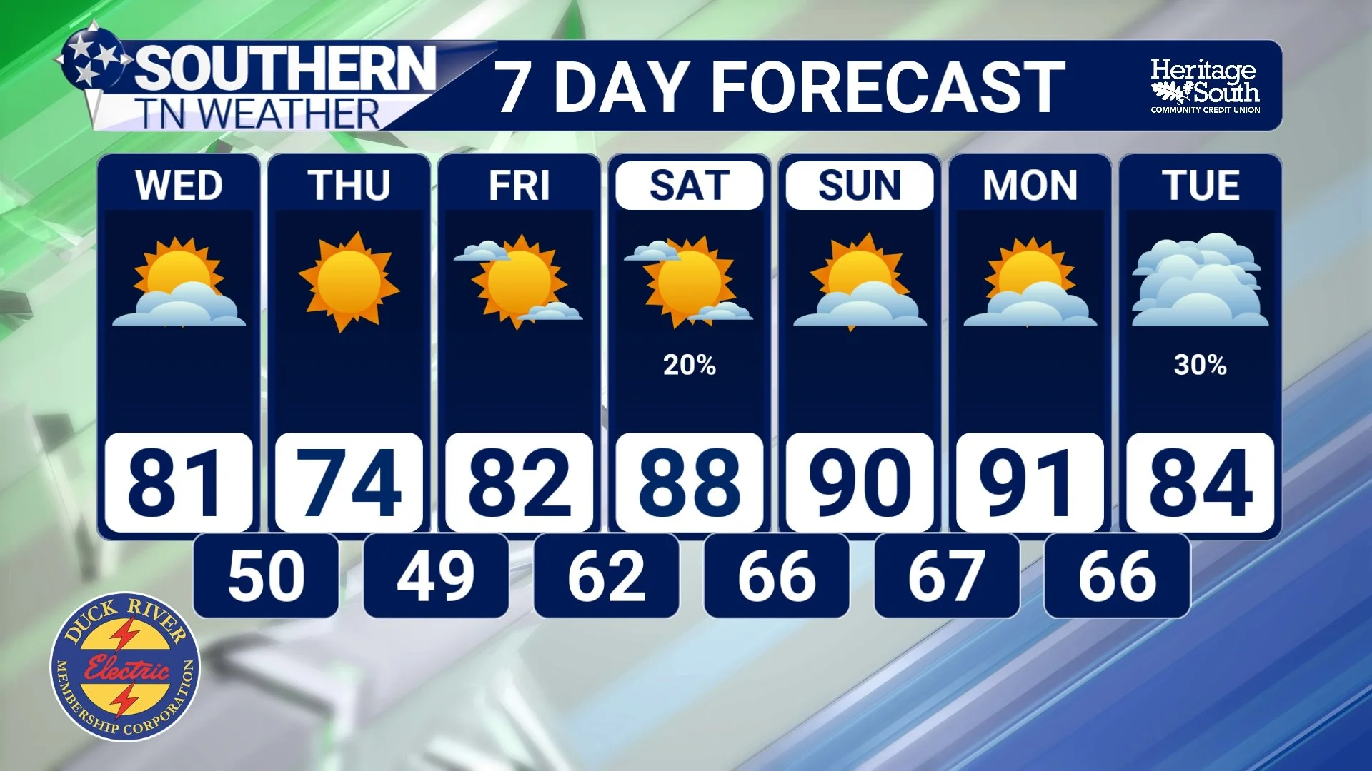
STNWX 7-DAY FORECAST
A Reminder About Early-Season Heat
Even though this won’t be an extreme heat wave, the first few hotter days of the year can still catch people off guard. Your body has not fully adjusted to warmer temperatures yet, especially after several weeks of relatively mild spring weather. If you’re spending extended time outdoors this weekend, make sure you stay hydrated and take breaks when needed.
And as always… never leave children or pets inside vehicles, even for a short amount of time. Interior vehicle temperatures can climb dangerously fast this time of year.
The Bottom Line 🧾
Pleasant spring weather continues through Thursday with highs mainly in the 70s and lower 80s.
A weak front Wednesday could produce a few isolated showers east of I-65, but most areas stay dry.
Cooler and refreshing air arrives Thursday behind the front.
A strong warming trend develops this weekend with highs climbing into the upper 80s and lower 90s.
Humidity levels should remain relatively tolerable despite the heat.
Drought conditions are expected to worsen with very little meaningful rainfall expected over the next 7 days.
Better rain chances may arrive sometime next week, but confidence remains low right now.
📰 Reminder: The Southern Tennessee Weather Blog, presented by Heritage South Community Credit Union, is updated Monday through Friday with fresh, locally tailored forecasts you can trust.