
An Update on Thursday’s Storm Potential…

The Southern Tennessee Weather Blog is proudly presented by Heritage South Community Credit Union.
We Help When Others Won’t!
Visit https://www.heritagesouth.org/ today to see how HSCCU can help YOU!
Quiet Today, But Changes Are Coming
It’s been a mostly cloudy and mild day across Southern Middle Tennessee so far, with temperatures sitting in the 50s and only a few spotty sprinkles showing up here and there. That light activity is tied to a weak disturbance passing overhead today, but it’s really just a placeholder for the main weather system we’re tracking for Thursday.
The overall takeaway up front is simple: Thursday looks wet and windy, but the threat for strong or severe storms continues to trend very low.
The Setup for Thursday: Strong System, Limited Storm Threat
A much stronger upper-level storm system is currently moving through the Pacific Northwest and into the Northern Rockies. By late tonight and Thursday, that system will shift east toward the Mississippi and Tennessee Valleys, dragging a strong cold front toward Middle Tennessee. From a meteorological standpoint, this system is impressive. Winds just a few thousand feet above the ground will be very strong, with a powerful low-level jet of 50 to 60 mph overspreading the region ahead of the front. That kind of wind energy is more than enough to grab a meteorologist’s attention. However, one critical ingredient is missing: instability.
Despite warm air moving in and temperatures climbing well into the 50s, and potentially the lower 60s, widespread cloud cover and rain will prevent the atmosphere from building meaningful storm fuel. Forecast soundings continue to show very weak instability, meaning thunderstorms will struggle to become organized or sustained. Any storms that do manage to develop are expected to remain mostly elevated, which greatly reduces the risk for severe weather at the surface.
This is why the Storm Prediction Center has completely removed Southern Middle Tennessee from the Marginal Risk as of earlier today.
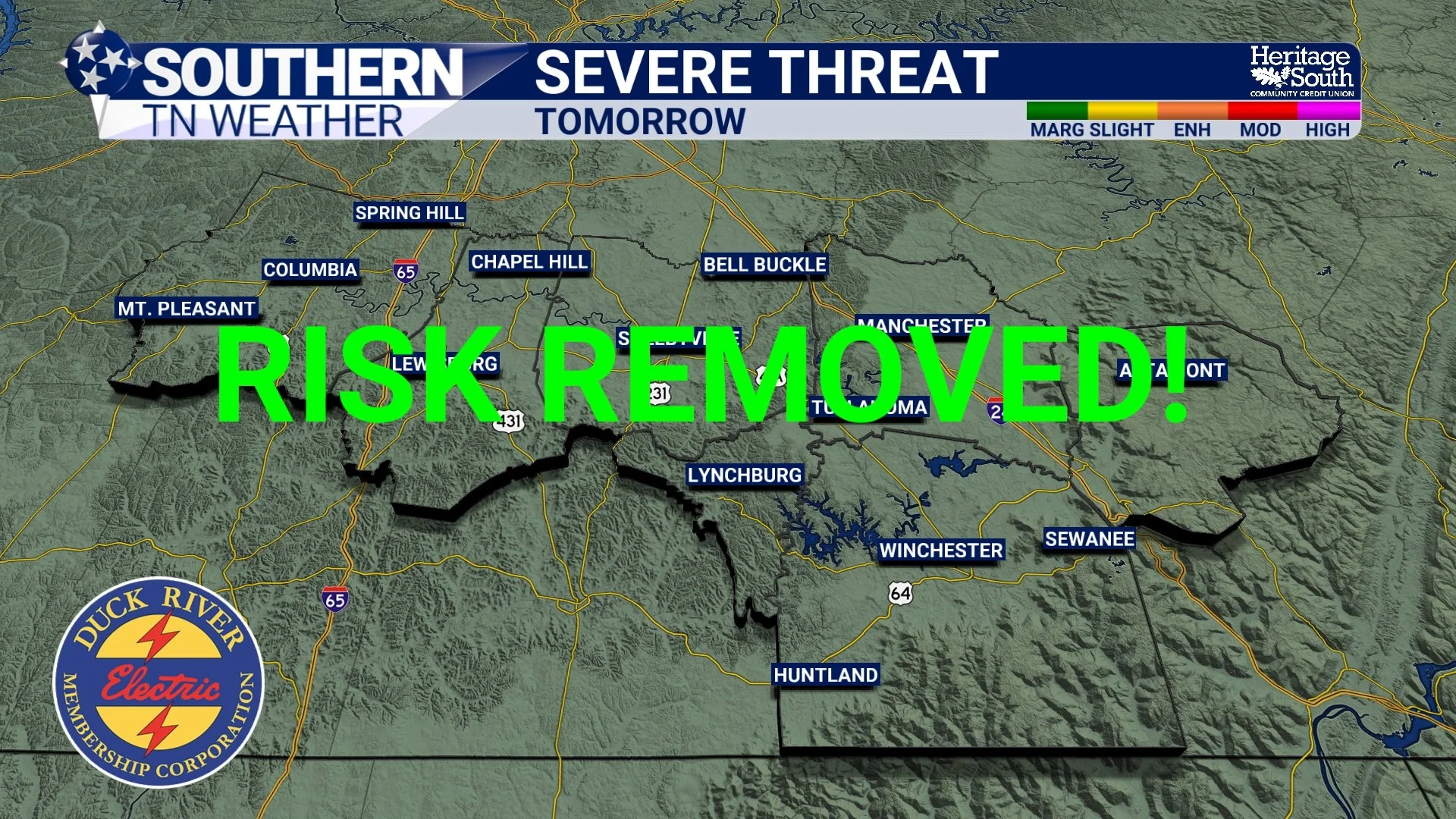
No More Risk! Yay!
What You’ll Notice the Most: Rain and Wind
While storms are not the main concern, rain and wind absolutely are. Rain chances will increase Thursday afternoon and remain high through Thursday evening as the cold front moves through. Most of Southern Middle Tennessee can expect widespread rainfall, with totals generally around one-half inch. It’s worth noting that the latest data has trended a bit drier with this system. Earlier forecasts supported totals closer to an inch, but now a quarter inch to three-quarters of an inch looks more realistic for most locations. A few isolated spots could still approach an inch, but that now appears to be the exception rather than the rule.
Winds will also pick up noticeably. Gusts between 30 and 35 mph are likely Thursday afternoon and evening. These gusts will be driven primarily by a tightening pressure gradient rather than thunderstorms, meaning breezy conditions may occur even outside of heavier rain. Because instability remains low, stronger convective wind gusts are unlikely. Still, it will be breezy enough to notice, especially for high-profile vehicles and loose outdoor items. Now is a good time to secure inflatable Santas and snowmen before heading to bed tonight!
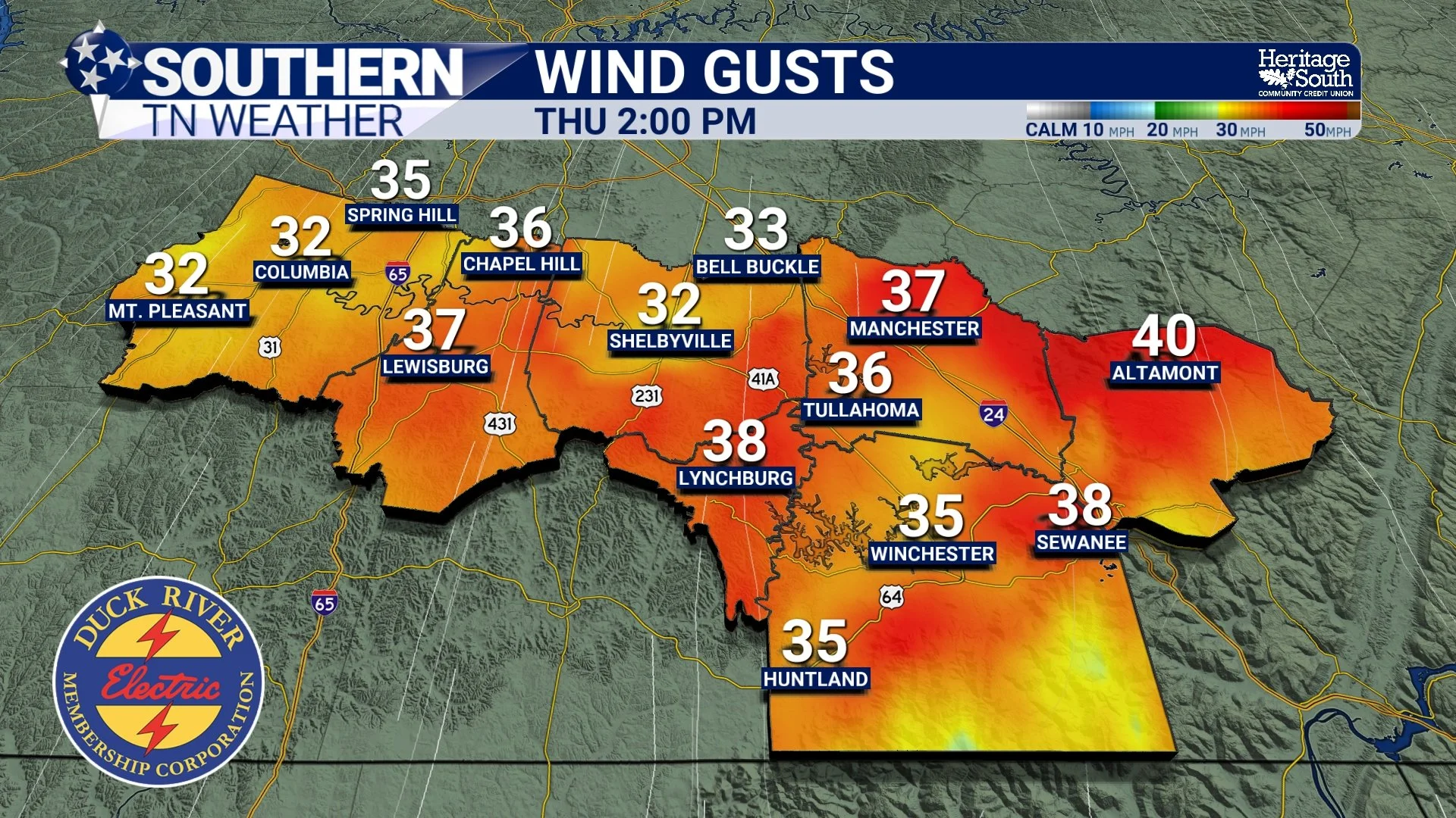
Wind Gusts - HRRR Model
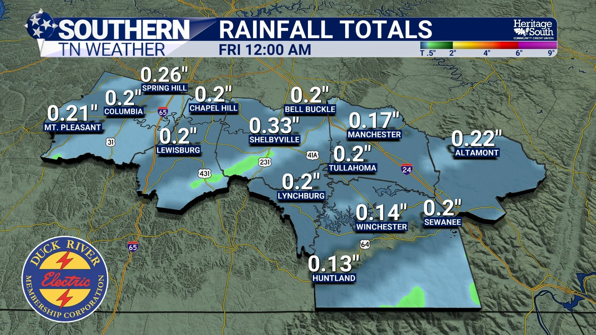
Forecasted Rainfall Totals - HRRR Model
Timing Breakdown
Thursday morning: Mostly cloudy, warm, and breezy
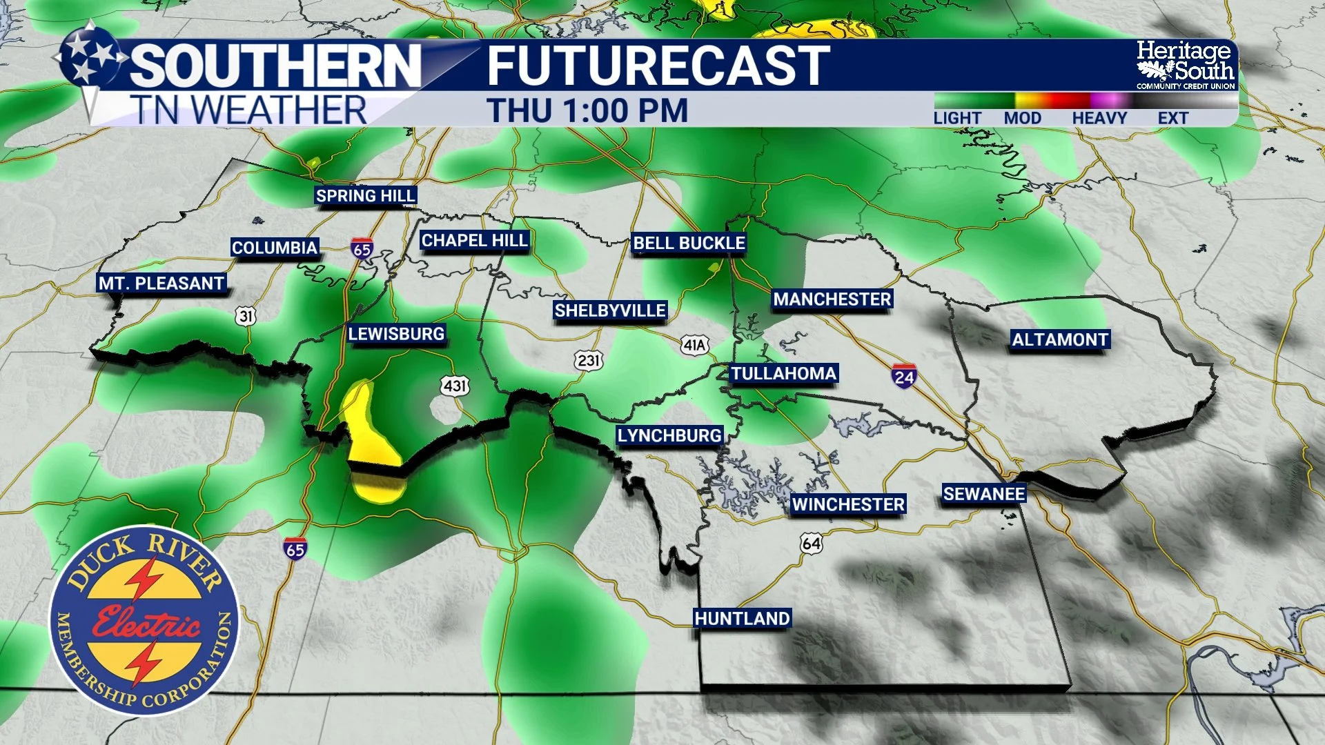
Thursday afternoon (12 PM – 4 PM): Rain coverage increases, winds become gusty
Thursday evening (4 PM – 8 PM): Periods of steadier rain, with isolated thunder possible. This will be the main window of impact ahead of the cold front
Late Thursday night (after 8 PM): Cold front passes, rain tapers off
Friday morning: Cooler and drier air moves in
Scattered Showers Early Thursday Afternoon - HRRR Model
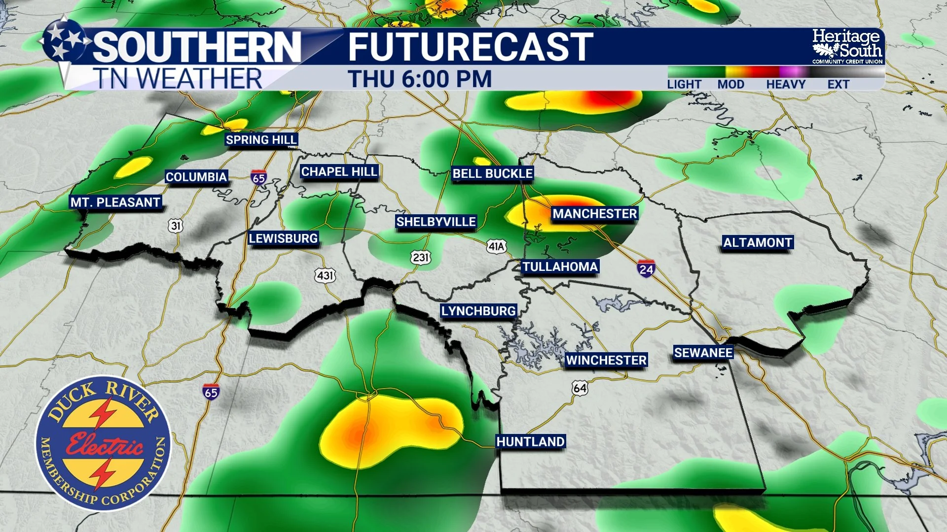
The “Main Event” Thursday Evening - HRRR Model
Looking Ahead Beyond Thursday
Behind the cold front, Friday will feel noticeably cooler but much quieter as dry air and high pressure build back into the region. While the overall pattern remains somewhat active heading into the weekend and early next week, temperatures continue to favor above-normal values as we approach Christmas, with no prolonged cold locked in at this time.
The Bottom Line 🧾
• Widespread rain is expected Thursday into Thursday evening
• Thunderstorm chances are low and severe weather is not expected
• Gusty winds of 30–35 mph will be the main non-rain impact
• Rainfall totals of 0.50–1.0 inch are likely
• Cooler, drier weather returns Friday
• Above-normal temperatures continue toward Christmas
This continues to be a high-confidence rain and wind event, not a severe weather setup. We’ll keep fine-tuning timing and impacts, but overall trends are in a good place for Southern Middle Tennessee.
📰 Reminder: The Southern Tennessee Weather Blog (Presented by Heritage South Community Credit Union) is updated Monday through Friday with fresh, locally tailored forecasts you can trust.