
Why Some Towns Keep Getting Rain... While Others Stay Dry

The Southern Tennessee Weather Blog is proudly presented by Heritage South Community Credit Union.
We Help When Others Won’t!
Visit https://www.heritagesouth.org/ today to see how HSCCU can help YOU!
If you've looked at the radar the past several afternoons, you've probably noticed something frustrating. One town picks up a soaking rain while another community just five or ten miles away doesn't see a single drop.
That's simply the nature of summertime weather, and it's exactly the pattern we'll remain in over the next several days.
Why Is The Forecast So Repetitive?
The large weather systems that bring widespread rain or severe weather have moved out of the picture. Instead, we're sitting beneath a weak upper-level disturbance with very light winds throughout the atmosphere. Without a strong cold front or organized storm system to focus rainfall, the sun does most of the work.
Each morning starts relatively quiet before temperatures climb into the upper 80s and lower 90s. As the ground heats up, warm, humid air begins rising into the atmosphere. Eventually, scattered showers and thunderstorms develop almost randomly across the region before fading again after sunset. Then the whole process repeats the next day.
Why Does One Town Get Soaked While Another Stays Dry?
One of the biggest frustrations during the summer is hearing someone say, "They called for a 50% chance of rain, and it never rained at my house." Meanwhile, someone just ten miles away is wondering if they need a boat to get home. That's exactly how summertime thunderstorms work.
The graphic below is a perfect example. Shelbyville is getting absolutely dumped on while Manchester and Winchester are sitting under blue skies. Both people could easily claim the forecast was "wrong," even though it was actually spot on. During the summer, we usually don't have large storm systems moving across the entire region. Instead, individual thunderstorms develop in small pockets where the atmosphere becomes just unstable enough. Tiny features like leftover outflow boundaries from yesterday's storms, subtle wind shifts, terrain, and even where clouds linger the longest can determine exactly where storms form.
That's why you'll often hear me say "scattered" showers and thunderstorms. It means some communities will get soaked while others stay completely dry. Forecasting whether storms will develop is usually straightforward. Forecasting which neighborhood gets one two days in advance? That's nearly impossible. So the next time your backyard misses out on the rain while the next town over picks up an inch, remember: that's not a busted forecast. That's just summertime in Tennessee.
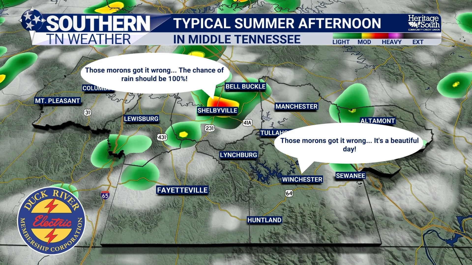
TYPICAL SUMMER AFTERNOON - MIDDLE TENNESSEE
Heavy Rain Continues To Be The Main Concern
The atmosphere remains loaded with tropical moisture, so any thunderstorm that develops will be capable of producing very heavy rainfall. Some locations could receive an inch or more of rain in less than an hour, while nearby communities stay completely dry. That means localized flooding remains the primary concern through the rest of the week, especially in low-lying or poor drainage areas.
The good news is that wind shear remains very weak, so organized severe weather is not expected. While a few storms may briefly produce gusty winds and frequent lightning, this doesn't look like a widespread severe weather pattern.
Looking Ahead
This overall setup changes very little through the rest of the workweek. Expect warm afternoons with highs in the upper 80s to lower 90s, plenty of humidity, and scattered afternoon and evening thunderstorms each day. Heat index values may approach 100 degrees later this week, but we're not anticipating another prolonged stretch of dangerous heat like we experienced last week.
Forecast guidance does suggest rain chances could gradually decrease early next week as slightly drier air tries to work into the region, although confidence remains somewhat low this far out.
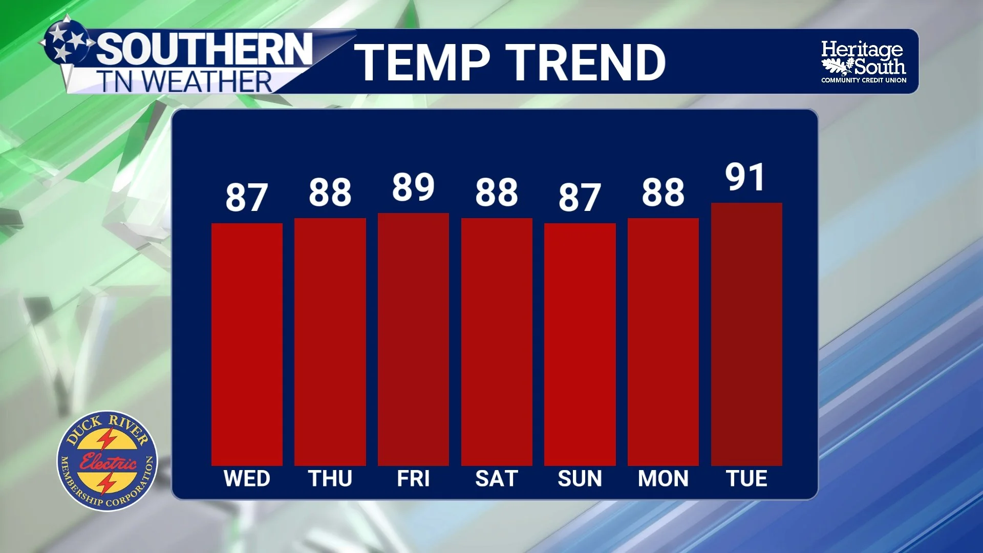
TEMP TREND - NEXT 7 DAYS
The Bottom Line 🧾
The weather pattern remains very typical for July.
Scattered afternoon thunderstorms will continue each day.
Rainfall will be very hit-or-miss from one town to the next.
Heavy rainfall and localized flooding remain the biggest concern.
Organized severe weather is not expected.
Highs stay in the upper 80s to lower 90s with heat index values near 100°.
📰 Reminder: The Southern Tennessee Weather Blog, presented by Heritage South Community Credit Union, is updated Monday through Friday with fresh, locally tailored forecasts you can trust.
