

The Southern Tennessee Weather Blog is proudly presented by Heritage South Community Credit Union.
We Help When Others Won’t!
Visit https://www.heritagesouth.org/ today to see how HSCCU can help YOU!
After finally picking up some much-needed rainfall over the weekend, we're already getting ready for ROUND #2! Another storm system is approaching Southern Middle Tennessee from the west, and this one has the potential to deliver a more substantial soaking rainfall across much of our region. In fact, some communities could receive more rain Wednesday than they've seen over the past several weeks combined!
But while the additional rainfall is certainly welcome considering our ongoing drought conditions, there are a few things I want everyone to be aware of before Wednesday arrives. The biggest concern with this system isn't necessarily severe thunderstorms. Instead, it's the potential for locally heavy rainfall, particularly during the overnight and early morning hours, when most of us will either be sleeping or getting ready for work and school.
The latest forecast guidance continues to show a fairly organized area of showers and thunderstorms moving into Southern Middle Tennessee late tonight and continuing through Wednesday. Most communities should receive a beneficial soaking, but there is also a small risk of localized flooding, especially in areas that received heavier rainfall over the weekend. So, let's break down the latest timing, expected rainfall amounts, severe weather potential, and what happens once this system moves away.
What's Happening in the Atmosphere?
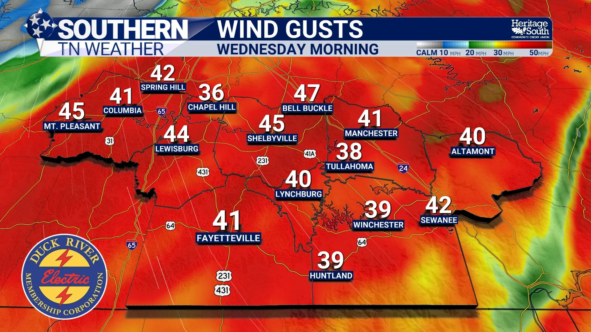
If you've stepped outside today, you've probably noticed that it's been rather breezy! That's certainly no coincidence. A developing low-pressure system across the central United States is helping create a tightening pressure gradient across our region, resulting in gusty southerly to southeasterly winds. Those winds are doing more than just blowing leaves around the yard. They're also transporting warmer, moisture-rich air northward, providing the fuel for our next round of rain and thunderstorms.
As our approaching storm system strengthens and moves northeastward, an associated cold front will gradually advance toward Southern Middle Tennessee. Meanwhile, increasing atmospheric moisture and stronger winds several thousand feet above the ground will help support the development of a widespread area of precipitation.
One of the more interesting aspects of this system is just how much moisture will be available. Forecast precipitable water values are expected to reach approximately 1.5–1.8 inches across portions of the region. Precipitable water represents the amount of liquid water that would result if all the moisture in a vertical column of the atmosphere were condensed. Those values are unusually high for early November, running roughly two to three standard deviations above normal in some locations.
Now, that doesn't automatically mean everyone will receive that much rainfall. However, it tells us that the atmosphere will be capable of producing some fairly efficient rainfall rates, especially where heavier showers and embedded thunderstorms develop.
Another factor worth watching is the orientation of the winds above the surface. Some guidance suggests that a strengthening low-level jet, around 10,000 feet above the ground, could become aligned with the approaching frontal boundary. When winds flow roughly parallel to a boundary, individual showers and thunderstorms can sometimes move repeatedly across the same general area rather than quickly passing through. Meteorologists refer to this as training, and it's one of the reasons I'm paying particularly close attention to the potential for locally higher rainfall totals.
When Will the Rain Arrive, and How Long Will It Last?
As we head through the remainder of Tuesday afternoon, increasing cloud cover and gusty winds will be the most noticeable changes. Afternoon temperatures will climb into the middle to upper 70s, which is rather warm for early November. Southeast winds will generally run around 15–20 MPH, with occasional gusts approaching 25–30 MPH.
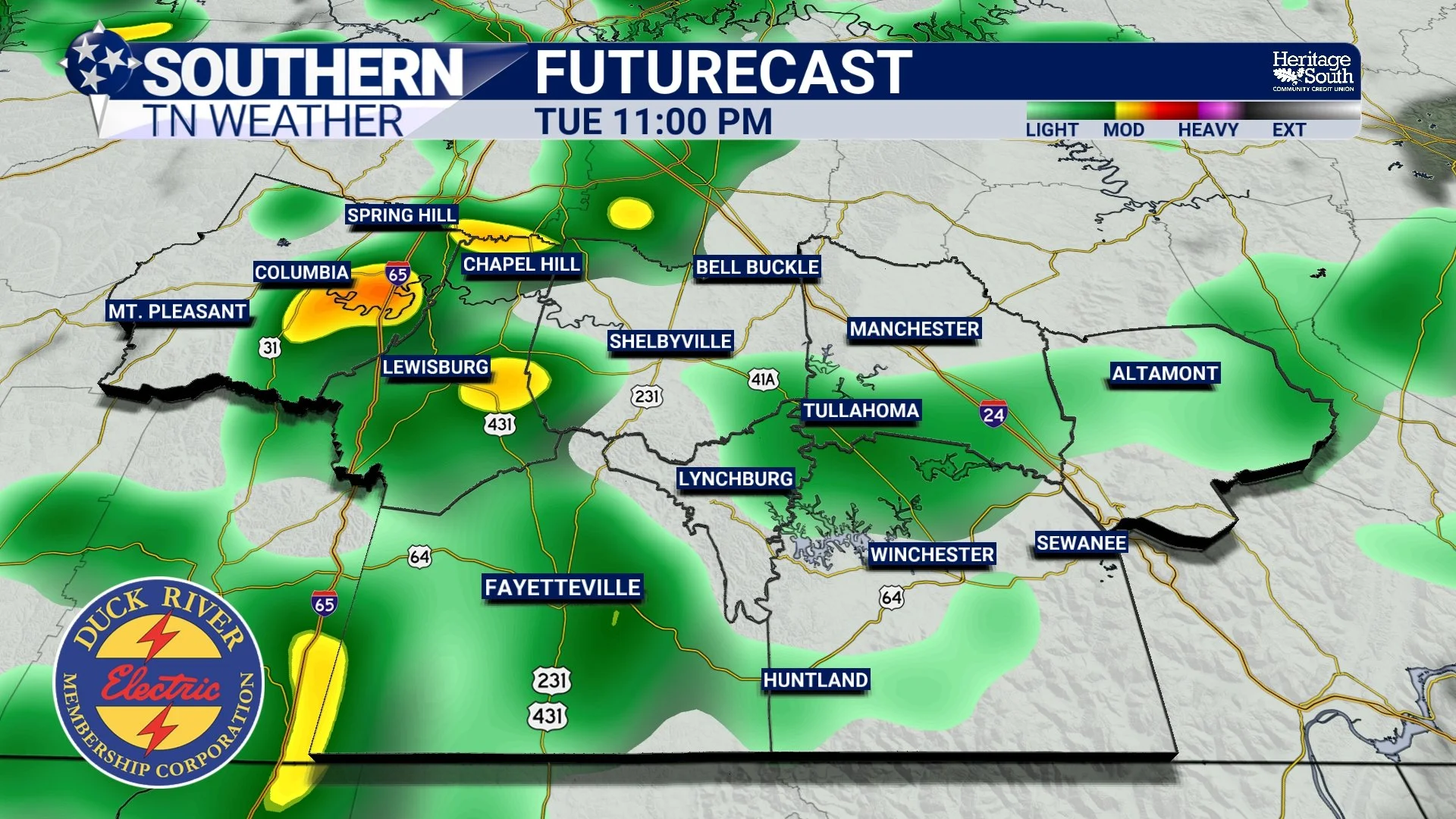
Most of us should remain dry through much of the afternoon and early evening. However, as moisture continues increasing, a few scattered showers could begin developing as early as 8–10 PM tonight, particularly across our western and southern communities. That doesn't mean widespread rainfall will begin that early, but I wouldn't be surprised to see a few showers popping up on radar before bedtime.
The more organized precipitation is expected to approach from the west later tonight. A line of showers and embedded thunderstorms should gradually move into western portions of Southern Middle Tennessee around midnight or shortly afterward, spreading eastward through the early morning hours Wednesday.
Communities across Maury, Marshall, and western Bedford counties will likely be among the first to experience the more widespread rainfall. From there, activity should gradually expand eastward toward Shelbyville, Lynchburg, Manchester, Winchester, and eventually the Cumberland Plateau.
At this point, the period from roughly 4 AM through noon Wednesday appears to offer the greatest opportunity for widespread rainfall across much of our coverage area. However, the exact timing will vary depending on your location, and some communities could experience their heaviest rainfall before or after that window.
Wednesday morning's commute could be particularly messy. Periods of moderate to heavy rain may reduce visibility, and water could accumulate on roadways, especially in low-lying areas and locations with poor drainage. If you're heading to work or taking the kids to school, I'd recommend allowing a little extra travel time.
As we head into Wednesday afternoon, the main area of rainfall should gradually begin weakening and shifting eastward. However, I don't expect everyone to dry out at the same time. Western communities will likely see improving conditions first, while areas farther east, particularly across Franklin, Coffee, and Grundy counties, could continue dealing with scattered showers and a few thunderstorms into the afternoon.
Most of the widespread rainfall should move away by Wednesday evening, although some lingering light showers or drizzle cannot be completely ruled out before conditions improve overnight.
How Much Rain Are We Expecting?
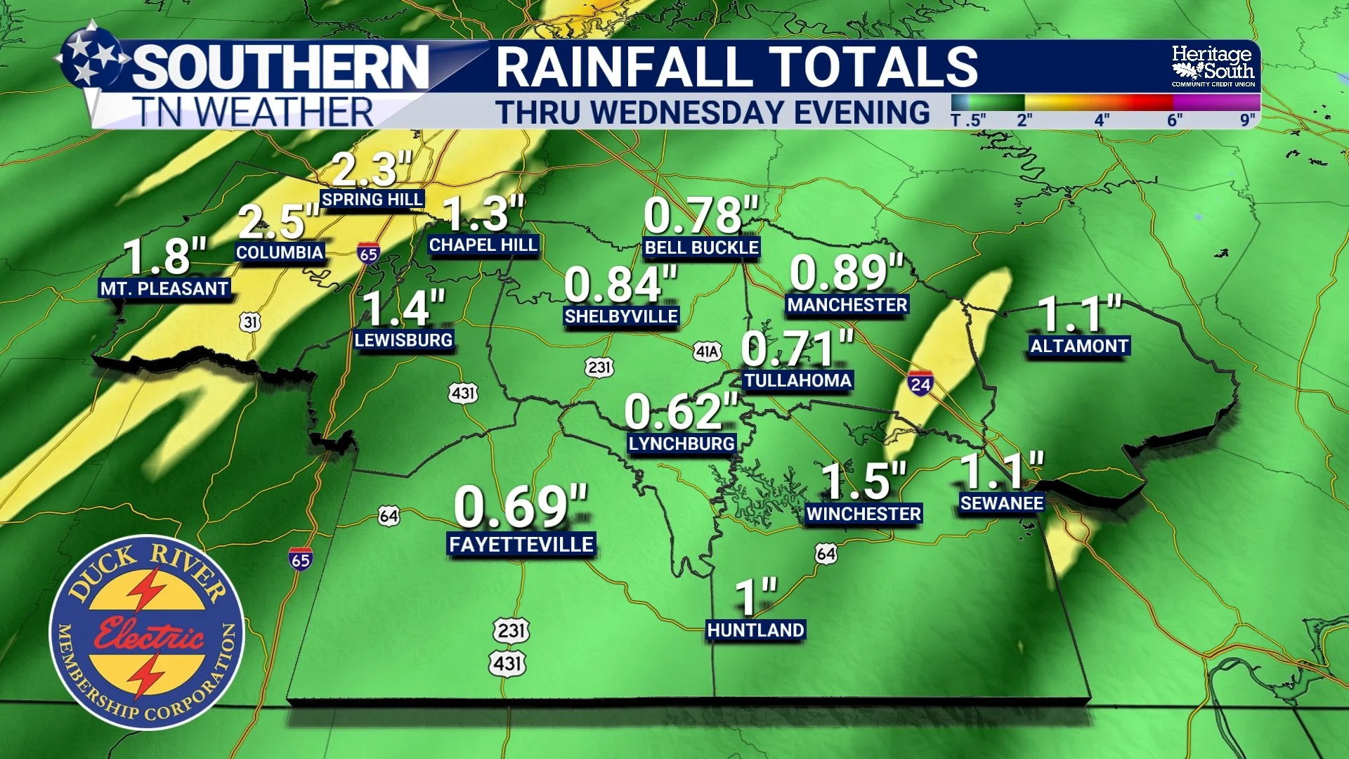
This is probably the biggest question heading into Wednesday, especially considering our ongoing drought. My current forecast calls for widespread rainfall totals of approximately 1–2 inches across much of Southern Middle Tennessee. However, some communities could receive more than that, particularly where heavier showers and thunderstorms repeatedly move across the same locations.
The latest guidance suggests that the greatest potential for higher totals may be across portions of our western coverage area, including Maury and Marshall counties. These locations will be closer to the corridor where stronger moisture transport and repeated rounds of precipitation could overlap. I wouldn't completely rule out isolated totals approaching or exceeding 3 inches in some locations. Farther south, some of the higher-end guidance suggests that localized amounts approaching 4 inches are possible within the broader storm system. However, those would be isolated outcomes rather than what I expect most communities to receive.
For areas farther east, including Coffee, Franklin, and Grundy counties, widespread rainfall is still expected, but exact totals will depend on how quickly the main precipitation band weakens and shifts eastward. One thing I want to emphasize is that rainfall distribution will NOT be perfectly uniform. One community might pick up 1.25 inches while another just a few miles away receives more than 2 inches. That's fairly common when thunderstorms become embedded within a larger area of widespread rainfall.
And considering that some of our western communities received a fairly substantial soaking Sunday, the additional rainfall could create some localized runoff concerns.
What About Flooding and Severe Weather?
Let's start with the flooding potential, because I believe that's the more important concern with this particular system.
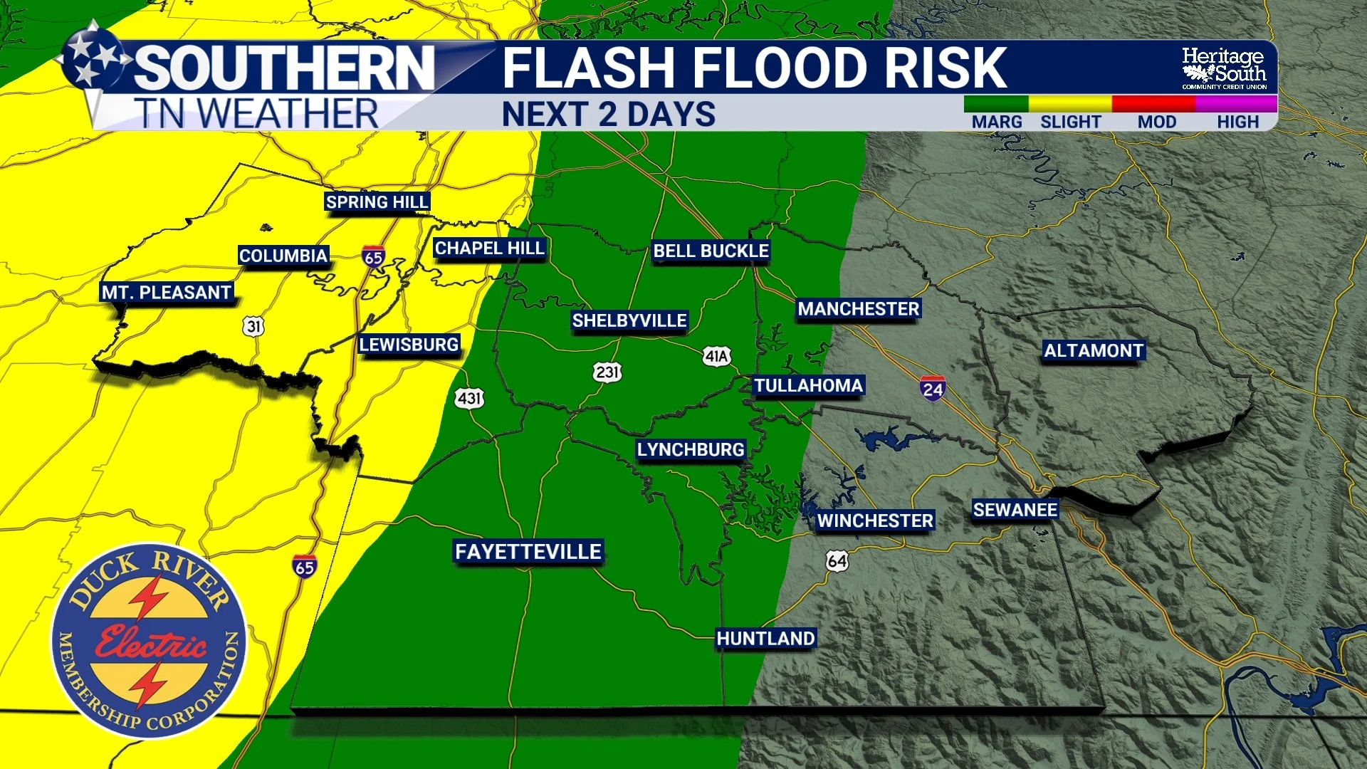
The Weather Prediction Center has highlighted portions of the broader region for an increased risk of excessive rainfall. Some areas farther west and south have been included in a Slight Risk, while a Marginal Risk extends across portions of the region for Wednesday. These outlooks cover different forecast periods, but they reinforce the same general concern: Locally heavy rainfall could produce isolated flooding.
The overall probability of flash flooding remains relatively low, but it certainly isn't zero. Some guidance suggests a 10–20% chance of flash flooding in the more favored areas, particularly along and west of Interstate 65.
Now, before anyone gets too concerned, I am NOT expecting widespread flooding across Southern Middle Tennessee. In fact, most communities should be able to handle the anticipated rainfall without significant problems. However, localized flooding could develop where heavier rainfall persists, especially along smaller creeks, in low-lying areas, and on roads with poor drainage.
It's also worth remembering that our ongoing drought doesn't automatically eliminate the possibility of flooding. Even though the ground has been unusually dry, rainfall can still arrive faster than the soil can absorb it, especially when intense downpours occur over a relatively short period.
As for the severe thunderstorm threat, I've got some encouraging news!
The Storm Prediction Center's latest Day 2 outlook does NOT include a categorical severe weather risk area for Wednesday. That doesn't mean thunderstorms won't occur, and it certainly doesn't guarantee that every storm will remain below severe limits. However, it does indicate that the overall environment is not particularly favorable for widespread organized severe weather.
The biggest limiting factor appears to be atmospheric instability. Although wind shear will be relatively strong, particularly in the lower levels of the atmosphere, the amount of energy available for thunderstorms is expected to remain rather limited.
Think of it this way: We may have some of the ingredients necessary for stronger thunderstorms, but we're missing a substantial amount of the atmospheric fuel needed to take full advantage of them.
A few stronger storms could still produce gusty winds, frequent lightning, and brief periods of heavy rainfall. The potential for an isolated severe storm cannot be completely ruled out, particularly closer to the Alabama state line. However, the overall risk of damaging winds and tornadoes appears LOW at this time.
I would be much more concerned about someone encountering a flooded roadway Wednesday morning than I would be about a widespread severe weather outbreak.
Will This Rain Finally Help Our Drought?
Absolutely! But we need to keep our expectations realistic. As we've discussed in several recent blogs, drought conditions have deteriorated significantly across Southern Middle Tennessee over the past several weeks. Portions of our region have experienced Severe to Extreme Drought, and while Sunday's rainfall certainly helped, it wasn't nearly enough to erase the accumulated moisture deficits.
Wednesday's system could provide another important step in the right direction.
If most communities receive the forecast 1–2 inches of rainfall, that would represent a substantial improvement in soil moisture compared to where we were just a week ago. The additional moisture could benefit pastures, vegetation, and agricultural operations that have struggled through our prolonged dry spell.
However, drought recovery is a process, not a single event. It takes time for moisture to work its way into deeper soil layers and eventually replenish groundwater and streamflow. Some locations may respond relatively quickly, while others could require several additional rainfall events before conditions meaningfully improve.
The encouraging news is that we're finally seeing the type of more active weather pattern we've been hoping for. Instead of going weeks without meaningful precipitation, we're now looking at multiple systems moving through our region within just a few days.
And that's certainly a welcome change!
What Happens After Wednesday?
Once the cold front moves through Southern Middle Tennessee Wednesday afternoon and evening, we'll begin noticing a gradual change in our weather. Winds will shift toward the west and northwest, allowing somewhat cooler and drier air to move into the region. Wednesday afternoon temperatures should generally climb into the upper 60s to lower 70s, although some warmer communities could reach the middle 70s before the cooler air becomes established.
By Thursday morning, temperatures should fall into the upper 40s and lower 50s across much of our area. With lighter winds and plenty of lingering ground moisture, patchy fog could also become an issue, particularly in valleys and other sheltered locations.
Thursday itself is looking considerably better, with decreasing cloud cover and afternoon highs generally in the upper 60s to lower 70s. A weak disturbance could bring a small chance of additional light showers late Thursday into Friday, but confidence in meaningful precipitation with that system remains low.
By Friday, another push of cooler air will begin arriving, setting the stage for a rather pleasant but chilly weekend. Saturday and Sunday should feature afternoon highs mainly in the lower to middle 60s, with overnight lows dropping into the 30s and lower 40s. Some of our colder valleys and higher elevations could approach the freezing mark, raising the possibility of frost in a few communities.
There are even some indications that temperatures could fall a little farther early next week, although it's too early to determine just how cold we'll get.
In other words, we're going from an unusually warm and breezy Tuesday to widespread rain Wednesday, followed by a much more seasonable November weather pattern heading into the weekend!
The Bottom Line 🧾
Tuesday afternoon: Increasing clouds, breezy conditions, and highs in the middle to upper 70s. Southeast wind gusts of 20–30 MPH are possible.
Tuesday evening: A few scattered showers could begin developing around 8–10 PM, but widespread rainfall is more likely later tonight.Overnight: A more organized line of showers and thunderstorms approaches from the west, spreading into Southern Middle Tennessee after midnight.
Wednesday morning: Widespread moderate to locally heavy rainfall is expected. The morning commute could be particularly wet, with reduced visibility and ponding on roadways.
Wednesday afternoon: Rain gradually becomes less widespread from west to east, although scattered showers and thunderstorms may linger across eastern communities.
Rainfall totals: Generally 1–2 inches across much of Southern Middle Tennessee, with isolated amounts exceeding 3 inches possible where heavier rainfall persists.
Flooding potential: LOW overall, but localized flooding is possible, especially along and west of I-65 and in areas that received heavier rainfall Sunday.
Severe weather: The overall threat remains LOW. A few stronger thunderstorms are possible, but widespread organized severe weather is not expected.
Thursday: Improving conditions with decreasing clouds, some morning fog, and highs in the upper 60s to lower 70s.
Friday through Sunday: Cooler, more seasonable weather returns. Weekend highs mainly in the 60s, with chilly mornings in the 30s and lower 40s.
📰 Reminder: The Southern Tennessee Weather Blog, presented by Heritage South Community Credit Union, is updated Monday through Friday with fresh, locally tailored forecasts you can trust
