

The Southern Tennessee Weather Blog is proudly presented by Heritage South Community Credit Union.
We Help When Others Won’t!
Visit https://www.heritagesouth.org/ today to see how HSCCU can help YOU!
Have you ever noticed how the wind seems to REALLY pick up out of the south a day or two before a storm system arrives? Maybe you've been outside enjoying an otherwise beautiful afternoon when the trees suddenly start swaying, the wind chimes won't stop ringing, and it feels like Mother Nature has turned on a giant fan! Then, a day or so later, here comes the rain! Believe it or not, there's a pretty fascinating meteorological explanation for why this happens so frequently across Southern Middle Tennessee. And with our next storm system approaching from the west, we're about to experience a textbook example of this very setup!
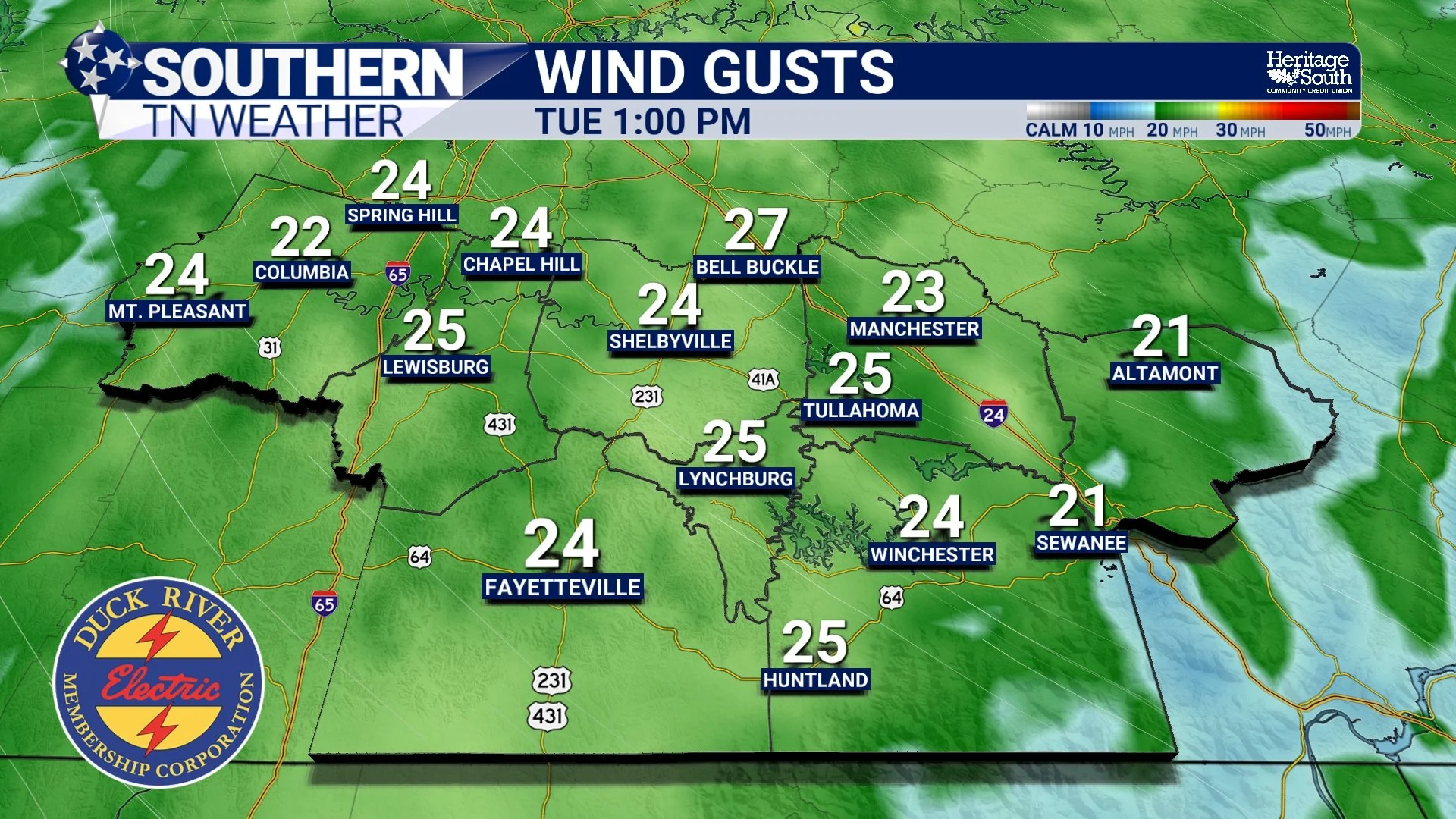
After finally picking up some much-needed rainfall over the weekend, we're already looking ahead to another round of beneficial rain arriving Wednesday. But before that rain gets here, we're expecting southerly to southwesterly winds to become rather gusty Tuesday, with gusts of 20–30 MPH possible across portions of our area. So, why does this happen? Why do winds frequently strengthen out of the south ahead of an approaching storm system? And why do they often shift to the northwest once the storm moves through? It all comes down to atmospheric pressure, the movement of weather systems, and the way our atmosphere transports heat and moisture.
It All Starts With High and Low Pressure
To understand why southerly winds frequently strengthen ahead of a storm system, we first need to understand something called the pressure gradient. You've probably heard me talk about high-pressure and low-pressure systems in previous weather discussions. High pressure is generally associated with sinking air and more settled weather, while low pressure is commonly associated with rising air, clouds, and precipitation. But here's something interesting: The atmosphere is constantly responding to differences in air pressure.
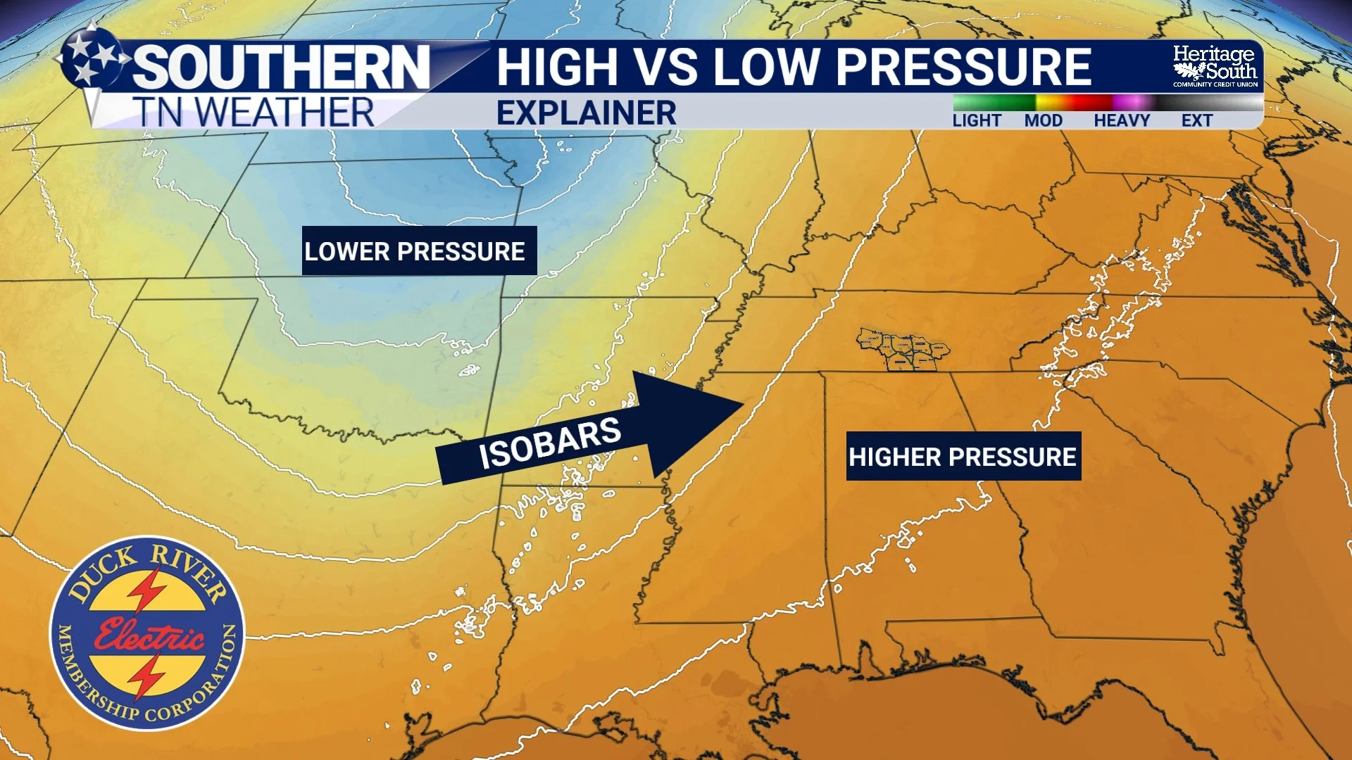
When we have an area of high pressure sitting to our east and an approaching low-pressure system developing to our west, a difference in atmospheric pressure develops between those two systems. That difference creates a force that helps drive the wind. Meteorologists call this the pressure gradient force. Think of it like a hill. The steeper the hill, the faster something tends to roll downhill. Atmospheric pressure works somewhat similarly. When the difference in pressure becomes greater over a relatively short distance, the pressure gradient becomes stronger, and wind speeds generally increase.
On a weather map, we can actually see this happening by looking at lines called isobars, which connect locations with equal atmospheric pressure. When those lines are spread far apart, winds are generally lighter. When they become tightly packed together, that's often a pretty good indication that gustier conditions are developing. And that's exactly the type of setup we're expecting Tuesday! As our next storm system approaches Southern Middle Tennessee from the west, the pressure gradient across our region will tighten. That will allow southerly to southwesterly winds to increase, even though widespread rainfall isn't expected to arrive until Wednesday. In other words, those gusty winds are one of the first noticeable signs that our atmosphere is beginning to respond to an approaching storm system.
But Why Do the Winds Come From the South?
Now, this is where things get particularly interesting! If air naturally responds to differences in pressure, you might assume that winds would simply blow directly from high pressure toward low pressure. However, our atmosphere isn't quite that simple. Because Earth is rotating, moving air experiences something called the Coriolis effect. In the Northern Hemisphere, this causes moving air to be deflected toward the right of its direction of travel. As a result, winds generally circulate clockwise around high-pressure systems and counterclockwise around low-pressure systems.
Now, imagine a typical weather setup across the central and eastern United States. We have an area of high pressure positioned somewhere to our east, while a low-pressure system and its associated cold front approach from the west. Between those two systems, the overall wind flow frequently becomes southerly or southwesterly across Southern Middle Tennessee. The clockwise circulation around high pressure to our east and the counterclockwise circulation around low pressure to our west both help support this southerly flow.
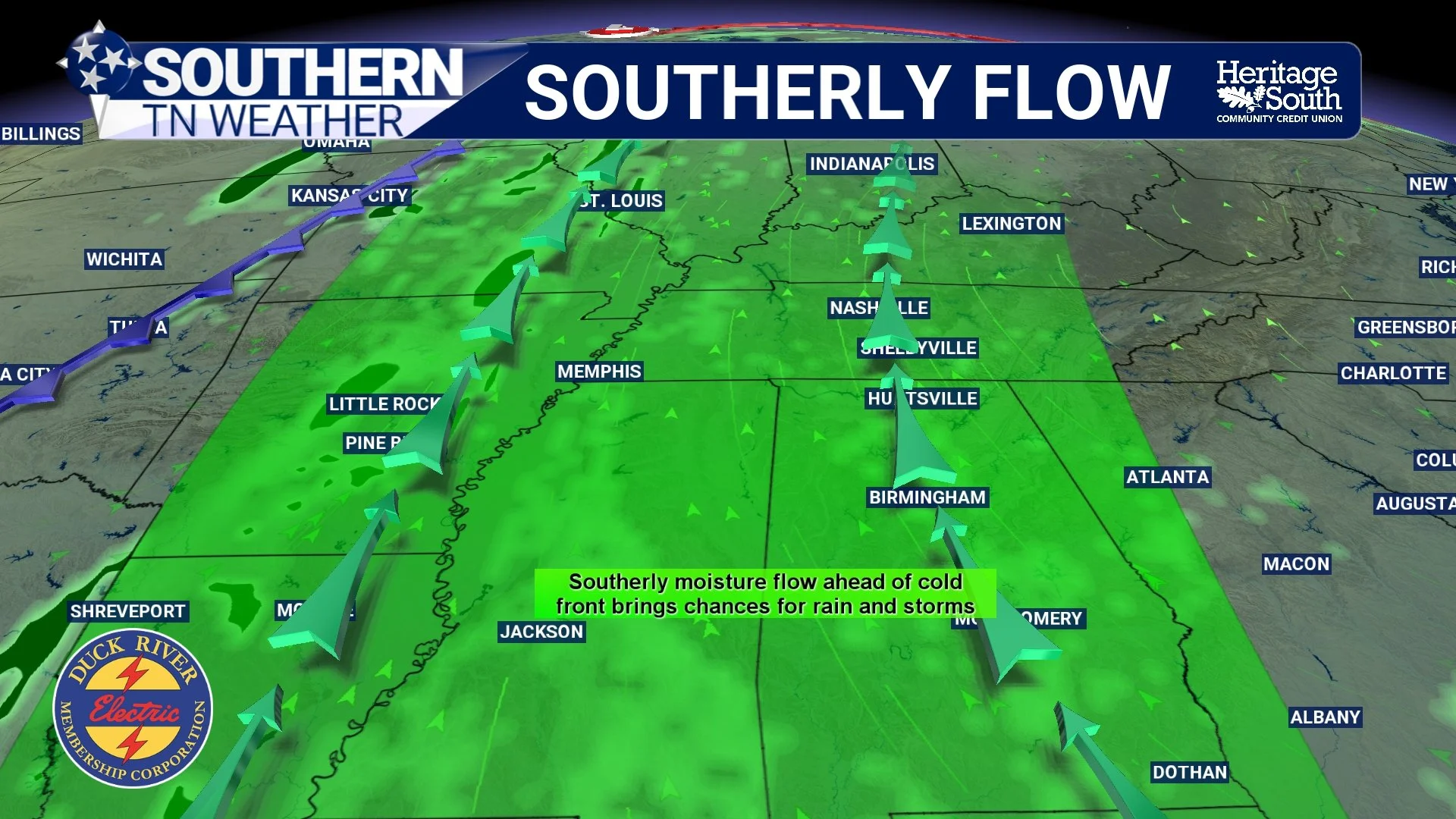
Of course, winds don't ALWAYS come from the south before a storm. The exact wind direction depends on where the pressure systems are located, how they're moving, and the structure of the approaching weather system. But with the typical west-to-east movement of many storm systems across the United States, southerly winds ahead of a cold front are extremely common around here. And those winds are doing something MUCH more important than simply making it difficult to keep your hat on! They're transporting heat and moisture northward from the Gulf.
One of the most important jobs of southerly winds ahead of a storm system is something meteorologists call warm air advection and moisture advection. Now, don't let those technical terms scare you! They're actually pretty simple concepts. Advection is just the horizontal movement of something through the atmosphere. Warm air advection means warmer air is being transported into a region, while moisture advection means additional atmospheric moisture is being carried into that same area.
When winds blow from the south or southwest across Southern Middle Tennessee, they're often transporting warmer, more humid air northward from the Gulf Coast region. That's why temperatures can sometimes become unusually warm just before a cold front arrives. We may start the day with relatively comfortable conditions, only to see temperatures climb well above normal as those southerly winds continue pumping warmer air into our region. At the same time, increasing atmospheric moisture provides one of the essential ingredients needed for cloud development, rainfall, and thunderstorms.
But here's an important distinction: Strong southerly winds don't automatically mean severe weather is coming! While those winds can help transport the heat and moisture necessary for thunderstorms, severe weather also depends on several other atmospheric ingredients, including instability, wind shear, and a mechanism capable of lifting air upward. You can have a very windy day ahead of a cold front without experiencing a single severe thunderstorm. And that's something worth remembering as we head toward Wednesday's system!
Why Are the Winds Sometimes Stronger During the Afternoon?
There's another interesting piece of this puzzle that explains why winds can become especially gusty during the daytime, even when a storm system is still hundreds of miles away. It's called atmospheric mixing.
During the day, sunshine warms the ground, which then heats the air immediately above it. As that warmer air rises, cooler air from above sinks to replace it, creating vertical mixing within the lower atmosphere. Now, here's where things get interesting. Winds several hundred or even a few thousand feet above the ground are frequently stronger than winds right at the surface because there's less friction slowing them down. When daytime heating produces enough vertical mixing, some of that faster-moving air can be transported downward toward the ground. The result? Sudden gusts of wind!
This is why you may notice a fairly steady breeze during the morning, followed by stronger and more frequent gusts during the afternoon. Of course, cloud cover, atmospheric stability, and the strength of the winds above the surface all influence how much mixing occurs. A thick layer of clouds can sometimes limit surface heating and reduce the amount of mixing. Nevertheless, when a strong pressure gradient combines with favorable daytime mixing, it's not unusual for winds to become rather gusty well ahead of an approaching cold front.
And once the front passes, the entire wind pattern can change! You've probably noticed this before, too. We spend a day dealing with warm, gusty southerly winds, a line of rain or thunderstorms moves through, and suddenly the wind starts blowing from the west or northwest. That's another classic feature of a passing cold front!
Ahead of the front, warmer air is typically being transported northward. Behind it, cooler and often drier air begins moving into the region from the west or northwest. As the cold front moves through Southern Middle Tennessee, the pressure pattern changes, and the winds respond by shifting direction. Sometimes the wind shift happens rather abruptly, particularly with a strong cold front. Other times, the transition is more gradual. And depending on the strength of the system, winds can remain gusty even AFTER the front passes because the pressure gradient may remain relatively strong behind the front.
So, the next time you notice warm, gusty southerly winds followed by rain and a sudden shift to cooler northwesterly winds, you'll know that you're witnessing the atmosphere responding to a passing weather system!
Now, Let's Talk About This Week's Forecast!
All of this brings us to a PERFECT real-world example unfolding across Southern Middle Tennessee over the next couple of days. After our widespread rainfall over the weekend, we're getting a brief break from the wet weather Monday and Tuesday. However, that break won't last very long!
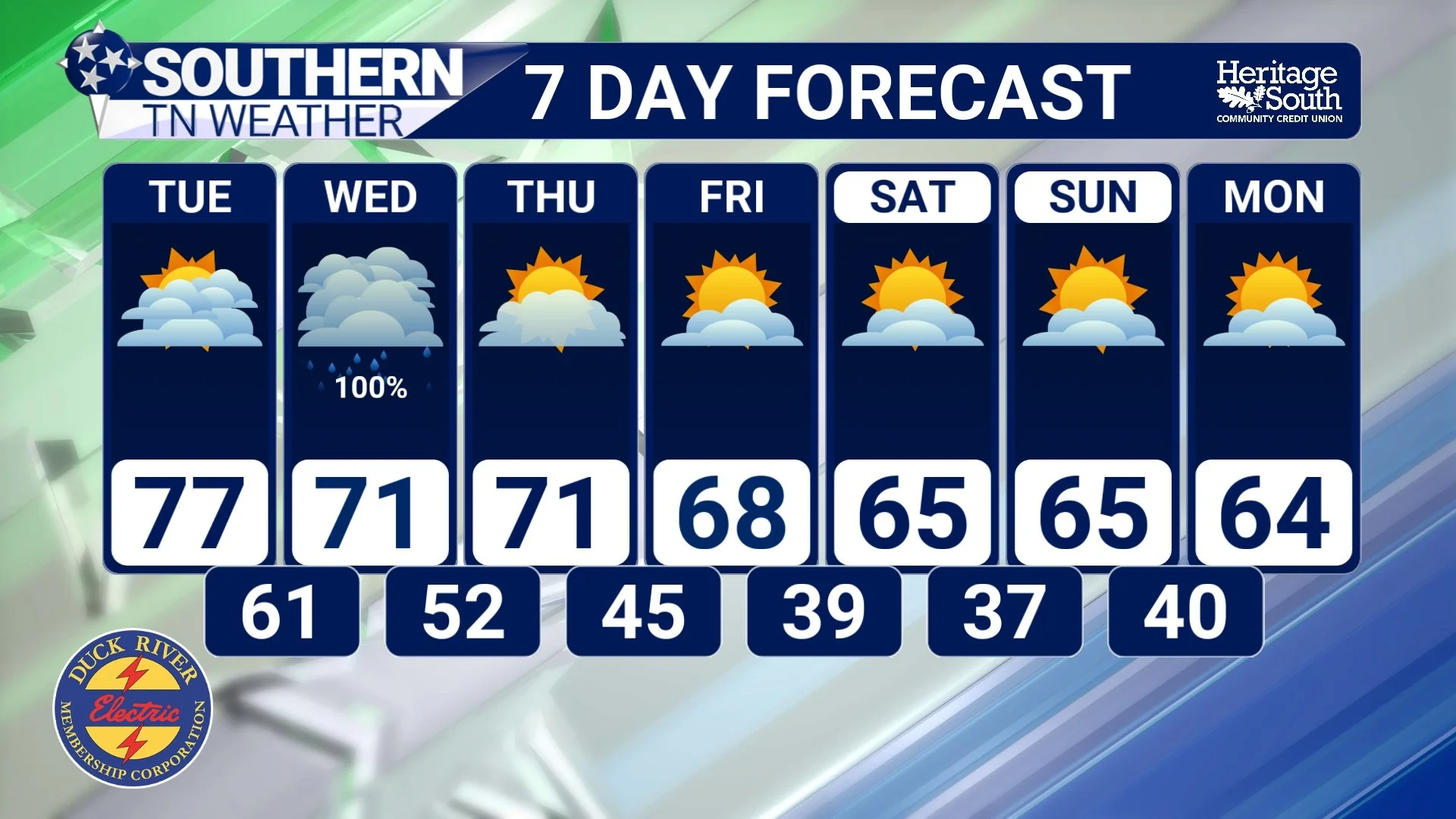
Monday will feature mostly cloudy skies with some breaks in the cloud cover, and afternoon temperatures climbing into the lower to middle 70s. Winds will remain out of the south to southeast, with some breezy conditions possible. Tuesday is when things really begin changing.
As our next storm system approaches from the west, the pressure gradient across Southern Middle Tennessee will tighten considerably. That will allow southerly to southwesterly winds to strengthen, with gusts of 20–30 MPH possible during the day. And remember what we just discussed about warm air advection? We'll be seeing that in action, too! Those southerly winds will help transport warmer air northward, allowing afternoon temperatures to climb into the middle to upper 70s across much of our region. That's roughly 10 degrees above normal for early November!
Despite the increasing clouds and gusty winds, most of Tuesday should remain dry. However, the atmosphere will be steadily becoming more favorable for precipitation as moisture continues increasing ahead of the approaching cold front. By late Tuesday night into Wednesday morning, our next round of rain and thunderstorms will begin moving into Southern Middle Tennessee.
Current forecast guidance suggests that a line of showers and thunderstorms will approach from the west during the overnight and early morning hours Wednesday. However, as this line moves into our region, it's expected to gradually lose some of its organization and intensity. One of the main reasons is timing. The line is expected to arrive during the overnight or early morning hours, when surface heating is limited and atmospheric instability is generally lower. That should help reduce the potential for organized severe thunderstorms across our region.
However, the atmosphere will contain quite a bit of moisture, and that means some of the showers and thunderstorms could produce locally heavy rainfall. In fact, atmospheric moisture values ahead of this system are forecast to climb unusually high for early November. That's a pretty good indication that this system will have plenty of moisture available to work with!
The latest guidance suggests that widespread rainfall amounts of around 1–2 inches are possible across portions of the region, although exact totals will vary considerably depending on the movement and intensity of individual showers and thunderstorms. Locally higher amounts cannot be ruled out where heavier rainfall persists. Considering our ongoing drought conditions, another round of beneficial rainfall would certainly be welcome!
Now, I do want to emphasize that the overall threat for widespread flash flooding currently appears relatively low because the system should maintain enough forward movement to keep most of the heavier precipitation from lingering over the same locations for too long. However, isolated localized flooding could still become a concern if heavier showers repeatedly move across the same communities, especially where substantial rainfall occurred over the weekend.
Rain should gradually become less widespread Wednesday afternoon and evening as the cold front moves through Southern Middle Tennessee, with most of the precipitation departing by late Wednesday night. Some patchy fog or lingering light showers could still be around early Thursday, but the overall trend will be toward improving conditions.
And remember that wind shift we discussed earlier? We'll likely experience that, too! As the front passes, winds will begin turning toward the west and northwest, allowing cooler and somewhat drier air to move into our region. Temperatures Thursday should generally remain in the upper 60s to lower 70s, with even cooler conditions expected as we head toward Friday and the upcoming weekend. By Saturday and Sunday, afternoon highs may struggle to climb much beyond the lower to middle 60s, while overnight temperatures could fall into the upper 30s and lower 40s in some communities.
That's going to feel MUCH more like November!
The Bottom Line 🧾
Why southerly winds? Approaching low pressure to our west and high pressure to our east frequently create a southerly wind pattern across Southern Middle Tennessee.
Why do they strengthen? A tightening pressure gradient increases wind speeds, while daytime atmospheric mixing can bring stronger winds from above down to the surface.
Why does it matter? Southerly winds frequently transport warmer, moisture-rich air northward, helping provide the ingredients needed for rain and thunderstorms.
Monday: Mostly cloudy skies with some breaks in the clouds. Highs in the lower to middle 70s.
Tuesday: Increasing clouds, warmer temperatures, and gusty south to southwest winds of 20–30 MPH. Highs in the middle to upper 70s, with most location
remaining dry.
Wednesday: Widespread rain and a few thunderstorms expected. Locally heavy rainfall is possible, but the overall severe weather threat currently appears low.
Rainfall totals: Around 1–2 inches possible across portions of the region, with locally higher totals possible. Exact amounts remain uncertain.
Thursday: Improving conditions as the cold front moves away. Cooler temperatures and a shift toward westerly or northwesterly winds.
Friday into the weekend: A return to more seasonable November weather, with highs generally in the 60s and chilly overnight lows.
📰 Reminder: The Southern Tennessee Weather Blog, presented by Heritage South Community Credit Union, is updated Monday through Friday with fresh, locally tailored forecasts you can trust
