
Why Have Storms Been Moving The "Wrong" Way? Here's What's Going On

The Southern Tennessee Weather Blog is proudly presented by Heritage South Community Credit Union.
We Help When Others Won’t!
Visit https://www.heritagesouth.org/ today to see how HSCCU can help YOU!
If you've watched the radar over the past several days, you may have noticed something that seems... well... backwards. Instead of the usual west-to-east movement we're accustomed to across Tennessee, many of our showers and thunderstorms have been drifting from east to west, or even southwest. It certainly isn't something we see very often, and it's generated quite a few questions from viewers.
The answer lies in the position of a stubborn area of low pressure that's been hanging around the Southeast.
Why Storms Normally Move West To East
Most of our weather systems travel from west to east because that's the direction the jet stream and upper-level winds usually flow across the United States. During a typical summer afternoon, thunderstorms form as the sun heats the ground. Once they develop, they're carried along by those prevailing winds several thousand feet above the surface. That's why we usually watch storms approach from the west before moving east across Middle Tennessee. But every once in a while, the atmosphere decides to throw us a curveball.
The Low Pressure That's Been Calling The Shots
Over the past week, a weak upper-level area of low pressure has been parked across Alabama, Mississippi, and the Lower Mississippi Valley. Unlike high pressure, where air circulates clockwise, air around low pressure rotates counterclockwise. Because Southern Middle Tennessee has been sitting on the northeastern side of that low, the steering winds several thousand feet above the ground have actually been blowing from east to west. Thunderstorms don't simply move wherever they want—they're steered by those winds aloft. As a result, many of our showers and thunderstorms have been traveling in directions that feel completely opposite of what we're used to seeing.
It's unusual, but it's a perfectly normal response to the placement of the upper-level low.
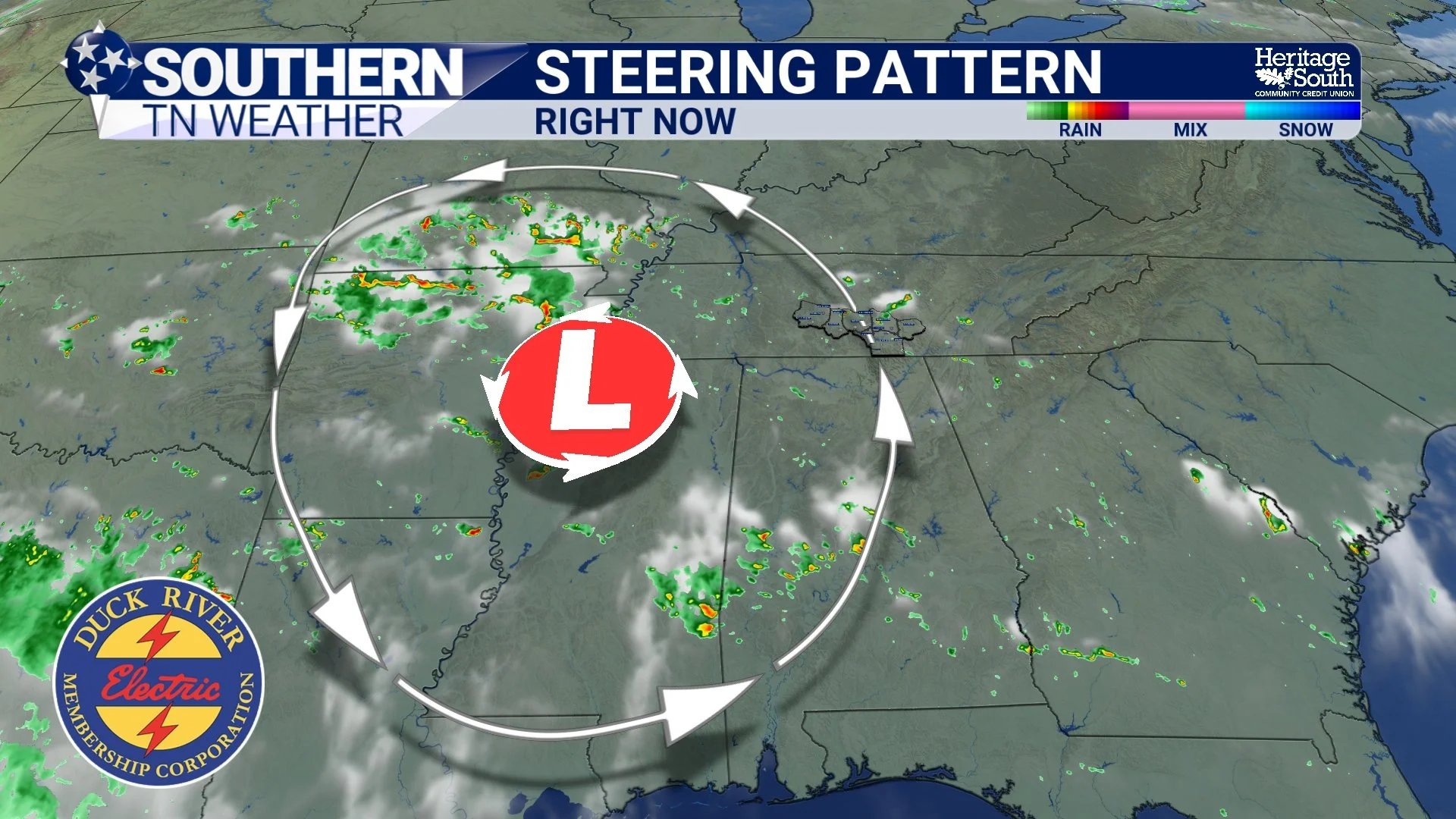
STEERING PATTERN - RIGHT NOW
Slow Movers Mean Heavy Rain
The position of the low hasn't just changed the direction of storm movement—it has also kept storms moving very slowly. With weak steering winds in place, thunderstorms haven't had much reason to hurry along. Instead, they've crawled across the landscape, producing torrential rainfall over the same locations for extended periods of time.
That's one of the biggest reasons many communities picked up 2 to 4 inches of rain over the past week while others only a few miles away received much less. Slow-moving storms can dump a tremendous amount of rain in one location before finally weakening. Fortunately, widespread flooding has been limited, although we've certainly seen pockets of localized flooding and ponding where storms repeatedly tracked over the same areas.
The Forecast Through The Weekend
We're not quite finished with the unsettled weather pattern just yet. Scattered showers and thunderstorms remain in the forecast each afternoon through Thursday, with the greatest coverage expected during the peak heating of the day before activity fades after sunset. Rain chances actually increase again Friday and Saturday as another disturbance and a weak convergence boundary move into the region. That should lead to more widespread showers and thunderstorms heading into the weekend.
The good news is that the atmosphere still lacks the ingredients necessary for organized severe weather. Wind shear remains weak, so the primary threats with any storm will continue to be heavy rainfall, frequent lightning, and localized ponding or minor flooding.
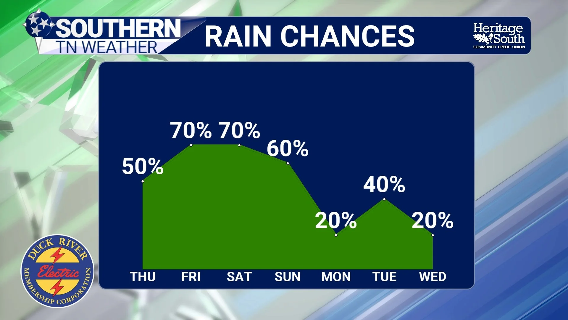
RAIN CHANCES - NEXT 7 DAYS
Heat Slowly Returns
As we head into the weekend and early next week, temperatures will gradually climb back into the upper 80s and lower 90s. Combined with humidity remaining high, afternoon heat index values will once again reach the low 100s, especially west of the Cumberland Plateau. Current indications suggest we'll remain just below Heat Advisory criteria, but it'll still be important to stay hydrated and take breaks if you're spending extended time outdoors.
A cold front currently looks to move through sometime Tuesday, which could bring slightly drier air and a little relief from both the humidity and rain chances during the middle of next week.
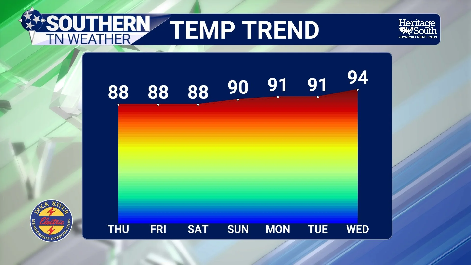
TEMPERATURE TREND - NEXT 7 DAYS
The Bottom Line 🧾
Storms have been moving east to west because of a stubborn upper-level low west of our area.
Air circulates counterclockwise around low pressure, changing the steering winds that thunderstorms follow.
Slow-moving storms have produced localized heavy rainfall and several inches of rain across parts of Southern Middle Tennessee.
Daily afternoon and evening storm chances continue through Thursday.
Rain chances increase again Friday and Saturday.
Severe weather remains unlikely, with heavy rain and lightning the primary concerns.
Heat and humidity gradually build back into the forecast this weekend and early next week, with heat index values returning to around 100 degrees.
📰 Reminder: The Southern Tennessee Weather Blog, presented by Heritage South Community Credit Union, is updated Monday through Friday with fresh, locally tailored forecasts you can trust.
