
Why Has Our Weather Been SO Boring? Meet the Atmospheric Ridge!

The Southern Tennessee Weather Blog is proudly presented by Heritage South Community Credit Union.
We Help When Others Won’t!
Visit https://www.heritagesouth.org/ today to see how HSCCU can help YOU!
SUNSHINE. HIGHS IN THE 70s. CHILLY MORNINGS. REPEAT. If you've checked our seven-day forecast lately, you've probably noticed something rather unusual. It looks almost EXACTLY the same from one day to the next! No thunderstorms, no significant cold fronts, no major temperature swings, and absolutely no meaningful rainfall. At this point, I'm beginning to think Mother Nature has put Southern Middle Tennessee's weather forecast on autopilot and walked away from the controls. 😂
Now, don't get me wrong. I'm certainly not complaining about beautiful autumn afternoons with temperatures in the 70s and crisp mornings in the 40s. This is the kind of weather people dream about during those miserable, humid days of July and August. But from a meteorological standpoint, our atmosphere has become remarkably repetitive, and there's a fascinating reason behind it.
The culprit? A large-scale atmospheric ridge and a stubborn area of surface high pressure. These features have helped keep our weather exceptionally quiet, and there's very little indication that our overall pattern will change anytime soon. In fact, we may go at least another SEVEN DAYS without meaningful rainfall, and potentially even longer. Unfortunately, while that sounds wonderful for anyone planning outdoor activities, it also means our ongoing drought is expected to continue worsening. So, what exactly is an atmospheric ridge? How can something happening thousands of feet above our heads influence whether we get sunshine or thunderstorms? And perhaps most importantly, what will it take to FINALLY break this stubborn weather pattern? Let's get into the science!
What Exactly Is an Atmospheric Ridge?
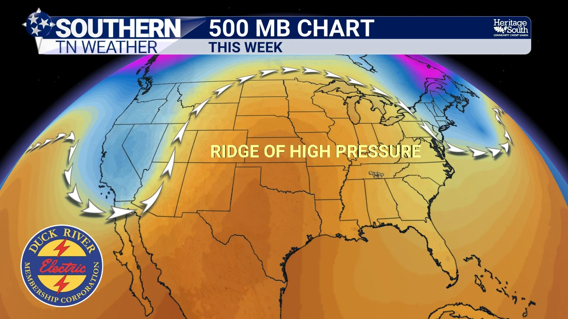
To understand our current weather pattern, we need to travel several miles above the Earth's surface into the middle and upper levels of the atmosphere. This is where meteorologists monitor large-scale features that help determine how weather systems move across the country. One of the most important features we look for is something called a ridge. In meteorology, a ridge is an elongated area of relatively high atmospheric pressure or higher geopotential heights on a constant-pressure weather map. You can think of it as a broad northward bulge in the atmospheric flow, although its exact orientation and position can vary considerably.
Meteorologists frequently examine these features on the 500-millibar pressure level, which is generally located around 18,000 feet above sea level. At that altitude, we're able to see the larger-scale circulation patterns that help steer storm systems, cold fronts, and other weather disturbances across North America. When a ridge becomes established over a region, it often favors relatively quiet weather, especially when accompanied by dry air and high pressure near the ground. That's because ridges are frequently associated with sinking air through portions of the atmosphere, a process known as subsidence.
As air sinks, it encounters increasing atmospheric pressure and becomes compressed, causing it to warm. This warming generally lowers the relative humidity of the sinking air, making it more difficult for clouds to develop and persist. In other words, the atmosphere becomes less favorable for the rising motion needed to produce widespread clouds, showers, and thunderstorms. That's one reason ridges are commonly associated with sunny skies and relatively stable weather conditions. However, it's important to understand that a ridge doesn't automatically guarantee sunshine everywhere. Moisture availability, surface heating, smaller disturbances, and other atmospheric processes can still produce clouds or precipitation under certain circumstances. In our current situation, though, the combination of ridging, surface high pressure, and exceptionally dry air has created an environment where meaningful rainfall is extremely difficult to generate.
Why Does High Pressure Keep Our Weather So Quiet?
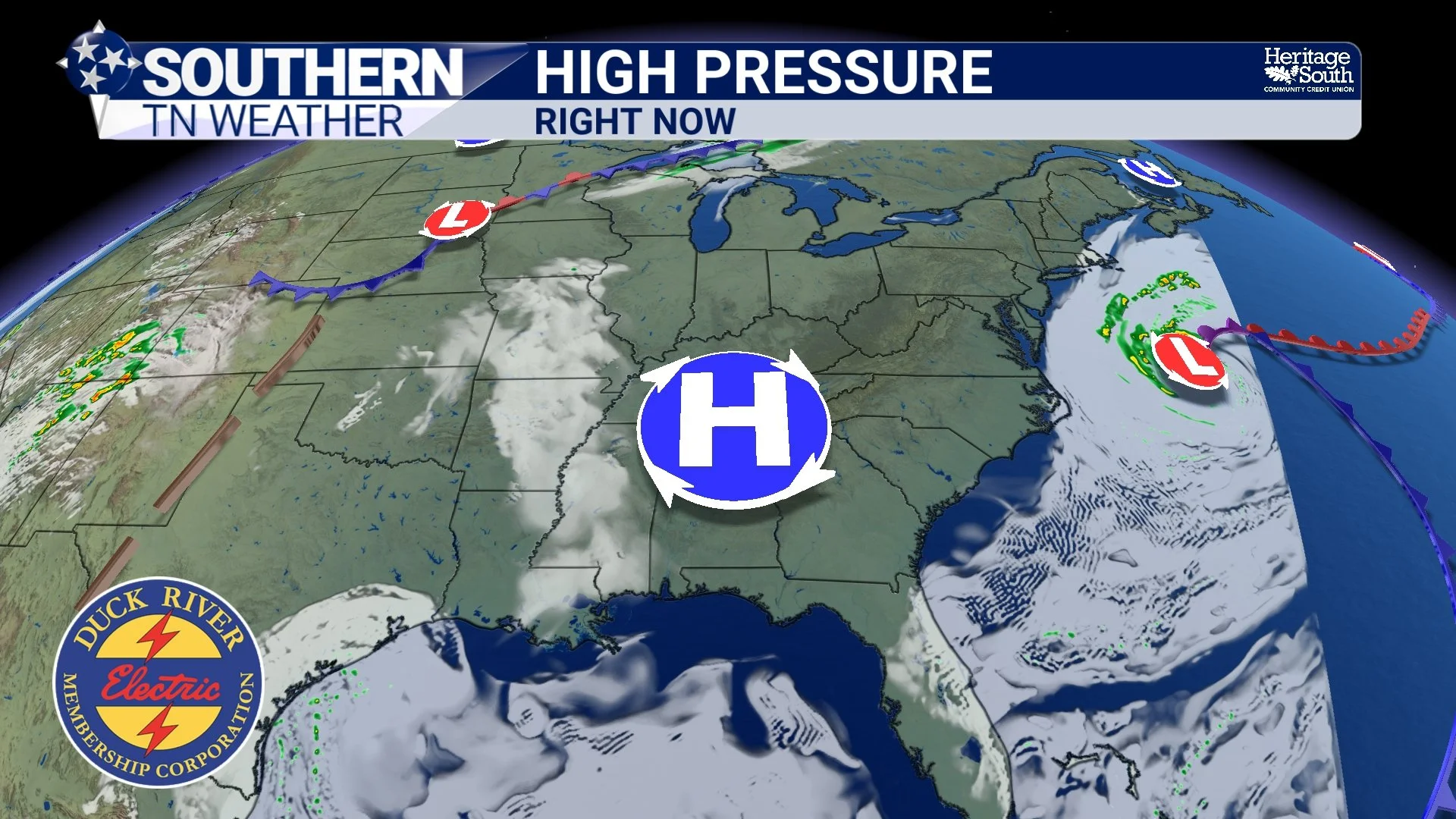
While the atmospheric ridge influences the larger-scale weather pattern several miles above us, high pressure closer to the Earth's surface plays an equally important role in what we experience each day. A surface high-pressure system is an area where atmospheric pressure is higher than its surroundings. In the Northern Hemisphere, winds generally circulate clockwise and outward around these systems. High pressure is often associated with sinking air, relatively stable atmospheric conditions, and fewer opportunities for widespread precipitation. Right now, a broad area of surface high pressure is dominating much of the eastern United States. A surface ridge situated to our north and west is gradually shifting across Middle Tennessee, maintaining a dry and stable atmosphere.
Meanwhile, our region remains under the influence of northwesterly flow in the middle and upper atmosphere, with larger-scale ridging building across the central United States and extending eastward. These features are helping maintain the remarkably consistent conditions we've experienced recently. And here's the really interesting part: High pressure doesn't have to remain parked in exactly the same location for our weather to stay the same. The ridge can shift, strengthen, weaken, or change its orientation while the broader atmospheric pattern continues favoring dry weather across Southern Middle Tennessee.
That's essentially what's happening right now. The atmospheric features are evolving, but not in a way that brings substantial moisture or organized storm systems into our region. The result is a forecast that looks almost identical every single day. For meteorologists, this is what we call a persistence forecast. Essentially, the weather you've experienced recently is a pretty good indication of what you can expect over the next several days. And right now, persistence is winning by a LANDSLIDE!
What Role Does the Jet Stream Play?
Now, you might be wondering why storm systems haven't been moving through our region like they normally would during October. After all, autumn is typically a transitional season when cold fronts become more frequent and larger temperature swings begin developing across the United States. A big part of the answer involves the jet stream, a relatively narrow corridor of strong winds located high in the atmosphere. The jet stream helps guide many of the large-scale weather systems that move across North America, including areas of low pressure and their associated fronts.
When the jet stream develops pronounced northward and southward bends, those bends are commonly associated with ridges and troughs. Ridges represent areas where the atmospheric flow bulges poleward, while troughs are elongated areas of lower heights that often favor cooler air and more unsettled conditions. Under the right circumstances, a ridge can steer approaching weather disturbances around a region or prevent them from moving into an environment favorable for significant precipitation. Meanwhile, storm systems may remain displaced well to our north, south, or west.
Our current pattern includes ridging across portions of the central and eastern United States, along with troughing farther east and over parts of the western United States. That arrangement has helped maintain dry conditions across Southern Middle Tennessee, even as disturbances continue moving through other parts of the country. This is also why a passing weather disturbance doesn't necessarily mean we're going to receive rainfall. If the atmosphere lacks sufficient moisture, any precipitation that develops higher above the ground may evaporate before reaching the surface. Meteorologists call that process virga, and it can occur when precipitation falls into a particularly dry layer of air. So, even when something manages to move through the atmosphere above us, that doesn't guarantee it'll produce measurable rainfall here at the surface.
Why Are Our Temperatures Staying So Consistent?
One of the most noticeable features of our current forecast isn't just the lack of rainfall. It's the remarkable consistency in temperatures from one day to the next. Afternoon highs have generally remained in the 70s, while overnight lows continue falling into the 40s. And according to the latest National Weather Service forecast discussions, that trend is expected to continue through at least the next seven days. Normally, October can bring some fairly dramatic temperature changes as cold fronts push through the region. We can go from warm afternoons in the 80s to chilly conditions in the 50s or 60s within a relatively short period. But when the larger-scale atmospheric pattern remains stable, those major temperature swings become much less likely.
With no significant cold fronts expected to move through Southern Middle Tennessee over the next several days, temperatures should remain relatively close to seasonal averages. Abundant sunshine allows the ground to warm efficiently during the afternoon, while clear skies and light winds promote radiational cooling overnight. That explains why we're experiencing such a noticeable difference between daytime and nighttime temperatures. You might need a jacket when you leave the house at 7 AM, but by the middle of the afternoon, short sleeves feel perfectly comfortable.
Some of our eastern communities could experience slightly cooler afternoon temperatures on Friday as a more easterly wind component develops. This would be associated with cooler air along the eastern side of the surface ridge and the influence of air flowing along the Appalachian Mountains. However, we're only talking about relatively minor temperature differences, not a major cold front or significant cooldown. For the most part, our temperatures are expected to remain remarkably consistent, with highs in the lower to middle 70s and overnight lows generally in the 40s.
The Downside to All This Beautiful Weather: Our Drought Is Getting Worse
Now, here's where this otherwise beautiful weather pattern becomes a real concern. While most people are enjoying the sunshine and comfortable autumn temperatures, our ongoing drought across Southern Middle Tennessee is becoming increasingly problematic. And unfortunately, this persistent dry pattern is doing absolutely NOTHING to help. Drought conditions are expected to worsen, with no meaningful rainfall anticipated for at least the next seven days and potentially even longer. In fact, their latest forecast discussion indicates that the National Blend of Models shows very little precipitation potential even out toward the ten-day forecast period. That's certainly not encouraging news for an area that desperately needs widespread, soaking rainfall.
When we experience extended periods without meaningful precipitation, moisture continues to be lost from the upper layers of the soil through evaporation and plant water use. Streams and other water sources may also respond to prolonged rainfall deficits, depending on local conditions and how much water remains stored in the surrounding landscape. The longer these dry conditions persist, the more difficult it becomes to recover from the accumulated moisture deficits. Even when rainfall eventually returns, a single event may not be enough to provide substantial drought relief, especially if the ground has become exceptionally dry over an extended period.
There's also an increasing concern involving fire danger. Dry grasses, fallen leaves, and other vegetation can become easier to ignite as moisture levels decrease. The National Weather Service in Huntsville expects afternoon relative humidity values to fall into the 25–30% range today, although light winds should help limit the overall fire-weather threat. It's important to distinguish between elevated fire concerns and more extreme fire-weather conditions. We're not necessarily expecting widespread wildfires or particularly dangerous wind-driven fire conditions today. However, the ongoing drought means vegetation is increasingly dry, and even relatively small fires can become difficult to control under unfavorable conditions.
I'd strongly encourage everyone to be cautious with outdoor burning, equipment that produces sparks, and other potential ignition sources. With no meaningful rainfall in sight, the fire danger concern isn't going away anytime soon.
Our Southern Middle Tennessee Seven-Day Forecast
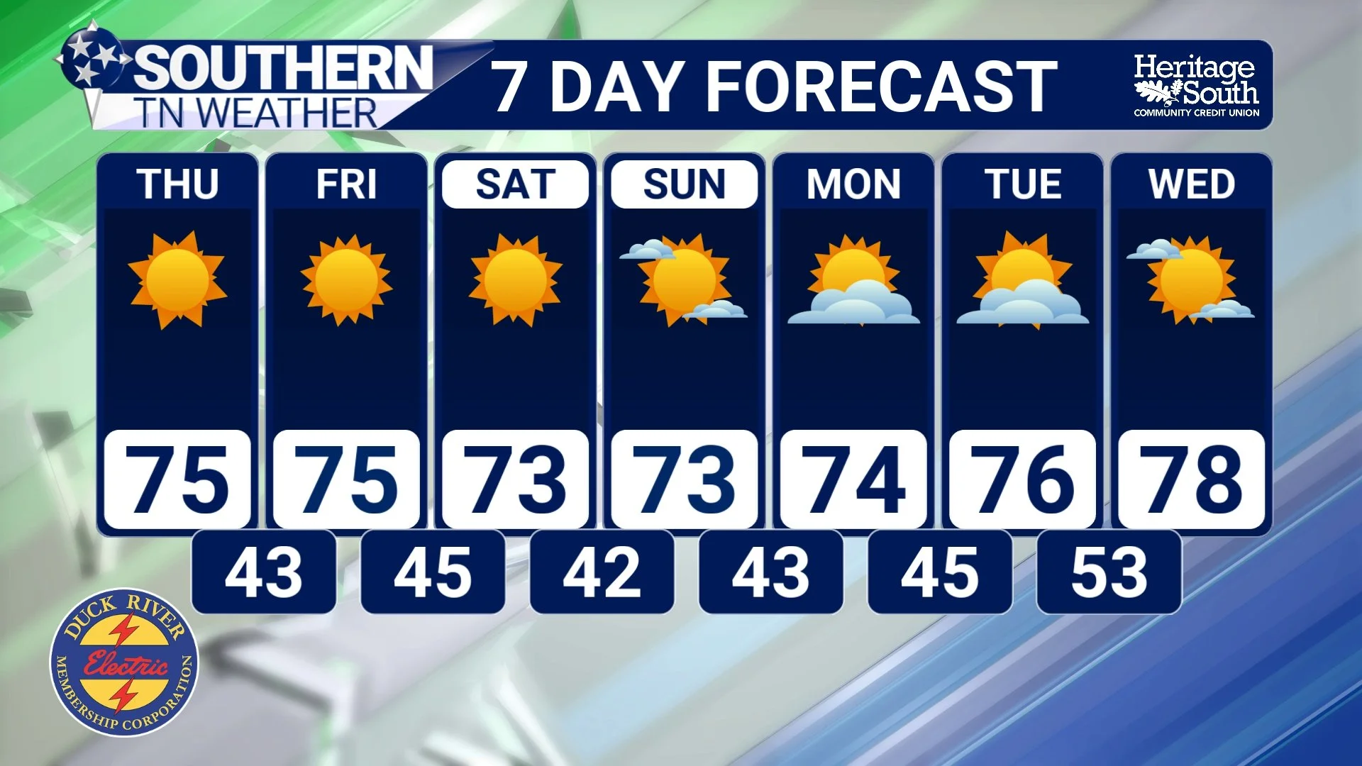
Wednesday, October 21: Another beautiful autumn afternoon is underway, with abundant sunshine and highs generally in the lower to middle 70s. The atmosphere remains exceptionally dry, and relative humidity values may drop into the 25–30% range during the afternoon. Winds should remain relatively light, limiting the overall fire-weather threat, although caution is still warranted because of our ongoing drought. Tonight will be clear and chilly, with lows generally in the 40s.
Thursday, October 22: Expect another sunny day with afternoon highs in the lower to middle 70s. Surface high pressure will continue dominating our weather, keeping winds relatively light and the atmosphere dry. Thursday night will be clear and cool, with temperatures falling back into the 40s.
Friday, October 23: The forecast remains remarkably similar, with mostly sunny skies and highs generally in the lower to middle 70s. Some of our eastern communities, particularly closer to the higher terrain, could run a couple of degrees cooler as winds develop a slightly more easterly component. Overnight lows will remain in the 40s.
Saturday, October 24: High pressure will continue influencing our weather, bringing another pleasant autumn afternoon with sunshine and temperatures generally in the 70s. No meaningful rainfall is expected, and overnight temperatures will fall back into the 40s.
Sunday, October 25: More sunshine and comfortable temperatures are expected, with afternoon highs generally in the 70s. Skies should remain mostly clear overnight, allowing temperatures to fall into the 40s once again. Unfortunately, the ongoing dry pattern will continue offering little relief from our drought.
Monday, October 26: The workweek should begin with another quiet weather day across Southern Middle Tennessee. Expect generally dry conditions, plenty of sunshine, and afternoon highs in the 70s. Overnight lows should remain in the 40s.
Tuesday, October 27: This is where a little more uncertainty begins entering the forecast. While the overall expectation remains predominantly dry, some forecast guidance suggests the upper-level ridge could begin weakening as a disturbance approaches the Mississippi River Valley. A cold front may also begin approaching the broader region, but confidence in any meaningful rainfall remains low. For now, expect temperatures generally in the 70s, with no substantial change in our weather pattern guaranteed.
Looking beyond the seven-day period, there's still no strong signal for a widespread soaking rainfall event. Drought conditions will likely continue worsening until we can finally get a more favorable atmospheric setup.
The Bottom Line 🧾
☀️ Our weather has become incredibly repetitive! Sunshine, highs in the 70s, and chilly mornings in the 40s will continue through at least the next seven days.
🌎 An atmospheric ridge is a major reason why. Ridging in the middle and upper atmosphere, combined with surface high pressure, is helping maintain dry and stable conditions.
🌬️ The jet stream helps steer weather systems. Our current large-scale pattern hasn't been favorable for bringing organized storms and widespread rainfall into Southern Middle Tennessee.
🔒 Persistent ridging doesn't automatically mean atmospheric blocking. However, the result has been a stubborn weather pattern with very little day-to-day change.
🌡️ Temperatures will remain fairly consistent, with no major cold fronts or significant temperature swings expected in the immediate forecast.
🌵 Drought conditions are expected to worsen. We desperately need widespread, soaking rainfall, and there's no clear indication of when that will arrive.
🔥 Fire danger remains a concern. Very dry air and drought-stressed vegetation will continue increasing the importance of outdoor fire safety.
🌧️ Rain chances remain extremely limited for at least seven days.
👀 A potential pattern change is worth watching next week, but confidence in meaningful rainfall remains low.
📰 Reminder: The Southern Tennessee Weather Blog, presented by Heritage South Community Credit Union, is updated Monday through Friday with fresh, locally tailored forecasts you can trust.
