
Why Is the Grass Wet in the Morning When It Hasn't Rained? The Science Behind Morning Dew!

The Southern Tennessee Weather Blog is proudly presented by Heritage South Community Credit Union.
We Help When Others Won’t!
Visit https://www.heritagesouth.org/ today to see how HSCCU can help YOU!
It hasn't rained in DAYS across Southern Middle Tennessee, so why in the world is your grass soaking wet every morning? You walk outside, your shoes get soaked, your windshield is covered in tiny water droplets, and yet the rain gauge is sitting at a big fat ZERO. Believe it or not, there's some pretty fascinating meteorology behind this everyday occurrence!
With our current weather pattern featuring clear skies, light winds, chilly mornings in the 40s, and afternoon highs in the 70s, this is the perfect opportunity to talk about something most of us experience regularly but rarely think much about. The answer is DEW, and while those tiny droplets might not seem particularly exciting, their formation involves several of the same atmospheric processes responsible for frost, fog, and even some of the dramatic temperature differences we experience across Southern Middle Tennessee during the fall months.
There's also another interesting question worth exploring. With our ongoing drought and practically no rainfall in the forecast, could all this morning dew actually provide some much-needed moisture? Unfortunately, the answer probably isn't what you're hoping to hear! But before we get into that, let's talk about where dew comes from and why certain weather conditions make it much more likely to develop.
Where Does Morning Dew Actually Come From?
One of the biggest misconceptions about dew is that it somehow falls from the sky overnight, almost like an extremely light rain shower. In reality, dew forms directly on surfaces when water vapor in the surrounding air condenses into tiny droplets of liquid water. Even when the atmosphere feels relatively dry, there's almost always some water vapor present. The key is getting a surface cold enough for that invisible water vapor to begin changing into liquid water.
To understand how that happens, we need to talk about something meteorologists mention all the time: the dew point. You've probably heard me discuss dew points during the summer when we're talking about humidity and the dreaded SWAMP BUTT SCALE. During the warmer months, higher dew points generally indicate more moisture in the atmosphere, making conditions feel increasingly muggy and uncomfortable. However, during autumn, dew points become especially important when we're discussing nighttime cooling and the formation of moisture on outdoor surfaces.
The dew point is the temperature to which air must cool, at roughly constant pressure and moisture content, to become saturated. For example, imagine we're enjoying a beautiful October afternoon with a temperature of 75 degrees and a dew point of 45 degrees. During the afternoon, the air temperature is considerably warmer than the dew point, so relative humidity remains fairly low. That's why the air feels comfortable and dry despite the presence of some moisture in the atmosphere.
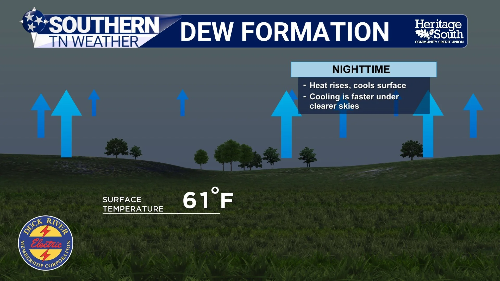
Once the sun sets, temperatures begin falling. As the air cools toward its dew point, relative humidity increases, eventually approaching 100% if the air becomes saturated. When grass, leaves, windshields, or other exposed surfaces cool to or below the dew point of the air immediately surrounding them, water vapor can begin condensing into liquid droplets. That's how you end up with a soaking wet lawn despite not receiving a single drop of rainfall overnight.
Here's where things get particularly interesting: The grass can actually become colder than the air temperature measured by your thermometer! That means dew can form on your lawn even when the official air temperature remains a few degrees warmer than the temperature needed for condensation at the surface. To understand why, we need to look at one of the most important processes in nighttime meteorology.
Why Clear Autumn Nights Are Perfect for Dew Formation
During the daytime, the ground absorbs energy from the sun, warming the surface and the air immediately above it. Once the sun goes down, however, the surface continues emitting energy in the form of infrared radiation without receiving the same amount of incoming solar energy to replace it. As a result, the ground begins cooling through a process meteorologists call radiational cooling.
Although radiational cooling occurs every night to some extent, certain weather conditions make it much more effective. Clear skies are especially favorable because clouds absorb and emit infrared radiation back toward the ground, slowing the rate of cooling. When skies remain clear, the surface can lose energy more efficiently, allowing temperatures near the ground to fall more quickly. Light winds also help because they limit atmospheric mixing, which would otherwise bring relatively warmer air down toward the surface and reduce the temperature difference between the ground and the air above it.
Combine clear skies, light winds, and sufficient moisture near the ground, and you've got an excellent setup for dew formation. That's one reason autumn mornings can be especially favorable for wet grass and damp windshields. As the days grow shorter, the nights become longer, giving the ground additional time to cool before sunrise. High-pressure systems, which frequently dominate our weather during the fall months, can also provide the clear skies and light winds needed for efficient nighttime cooling.
Our current weather pattern across Southern Middle Tennessee is a great example. High pressure is expected to remain firmly established across the region throughout the week, bringing mostly sunny afternoons, clear nights, and temperatures falling into the 40s. Those conditions can support dew formation, particularly in sheltered valleys and other locations where winds become nearly calm overnight. However, there's an important catch: Clear skies and light winds don't automatically guarantee heavy dew. There still needs to be enough moisture near the surface, and our atmosphere is exceptionally dry right now. If the dew point is too low, surfaces may never cool enough to reach saturation before sunrise.
Why Is the Grass Wet, but the Sidewalk / road Is Dry?
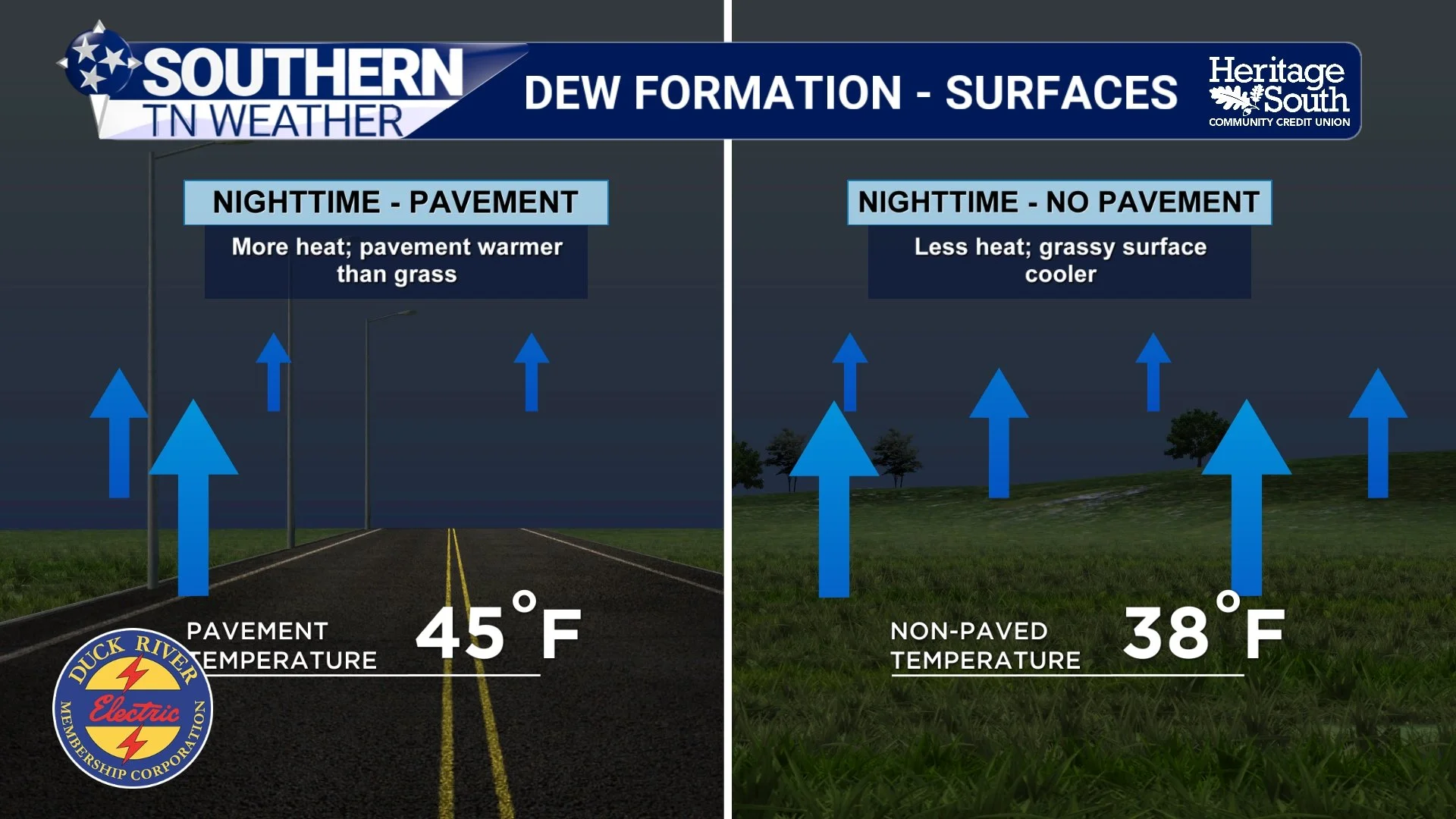
Have you ever noticed that your grass can be completely covered in dew while the sidewalk or driveway right next to it remains almost entirely dry? This is another great example of how different surfaces respond to nighttime cooling.
Grass blades are relatively thin and have very little thermal mass, allowing them to cool rapidly after sunset. Concrete, asphalt, and other solid surfaces generally store considerably more heat during the daytime and release that energy more slowly overnight. As a result, grass may cool to the dew point while nearby pavement remains warm enough to prevent condensation. That's why your lawn can look like it received a light rain shower while the driveway stays dry!
The same general principle helps explain why car windshields frequently become covered in moisture overnight. Exposed glass can lose heat efficiently through radiation, sometimes allowing its surface temperature to fall below the dew point of the surrounding air. Water vapor then condenses directly onto the windshield, creating those tiny droplets that greet you when you're trying to leave for work in the morning.
Of course, pavement and other solid surfaces can develop dew under the right conditions, too. The important thing to understand is that different materials cool at different rates, which means moisture doesn't necessarily form uniformly across your yard, driveway, or vehicle.
What's the Difference Between Dew and Frost?
Since we're getting deeper into autumn, this is also a good opportunity to explain the difference between dew and frost. Both involve moisture and cooling, but the physical processes aren't exactly the same.
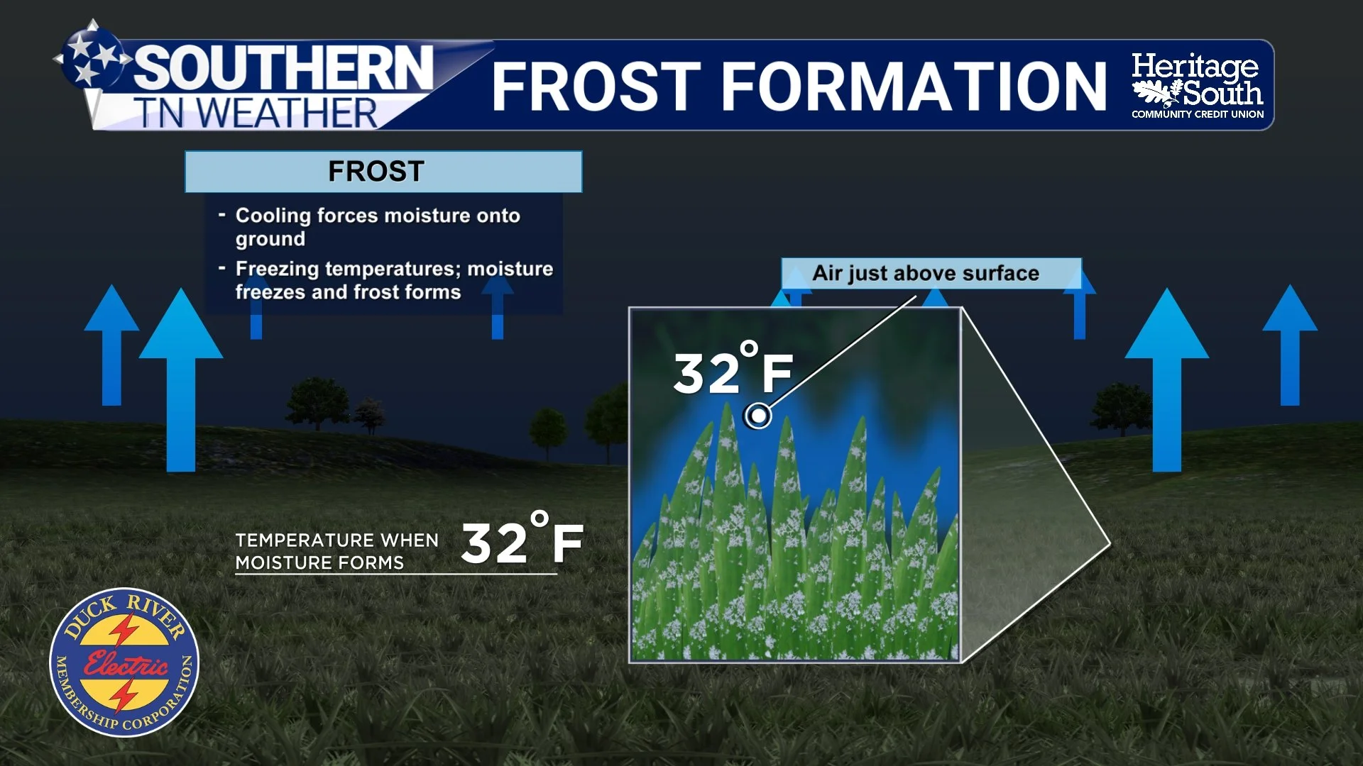
Dew forms when water vapor condenses into liquid water on a surface. Frost, on the other hand, generally develops when water vapor deposits directly onto a surface as ice crystals, without first becoming liquid water. The temperature of the surface is especially important in determining which process occurs. When a surface remains above freezing and cools to its dew point, liquid dew can develop. When a surface falls below freezing and reaches the frost point, water vapor can deposit as ice crystals.
One particularly interesting detail is that frost can form even when the official air temperature remains ABOVE 32 degrees! Official air temperatures are generally measured approximately five feet above the ground, while grass blades and other exposed surfaces can become several degrees colder through radiational cooling. For example, the air temperature might be 35 degrees, but the grass itself could be below freezing. Under the right moisture conditions, frost could develop even though your thermometer never officially reached 32 degrees.
There's also the possibility of liquid dew forming first and subsequently freezing as surface temperatures fall below freezing. This produces frozen dew rather than frost formed directly through deposition, although both can leave exposed surfaces covered in ice. Local terrain also plays an important role, which is why one community might experience frost while another location only a few miles away remains frost-free. Sheltered valleys and hollows often cool more efficiently on clear, calm nights because cold, dense air tends to settle into low-lying areas.
Can Morning Dew Actually Help During a Drought?
Now, let's address the question that's probably on quite a few people's minds. With Moderate to Severe Drought continuing across much of Southern Middle Tennessee, could morning dew actually help replenish some of our missing moisture?
The answer is yes, but only on a very small scale. Dew can provide moisture directly to plant surfaces, and certain plants, mosses, and other organisms can benefit from that moisture. However, the amount of water deposited through dew is generally extremely small compared to what we receive during a typical rainfall event. Even a relatively heavy dew event may only produce the equivalent of a few hundredths of an inch of water, with many events producing considerably less.
Unlike rainfall, which can soak into the ground and replenish soil moisture at greater depths, dew primarily forms on exposed surfaces. Some of that moisture may eventually drip into the soil, but much of it simply evaporates after sunrise as temperatures begin warming. That means your grass might look soaking wet at 7 AM while the soil underneath remains exceptionally dry.
Unfortunately, our ongoing drought requires much more substantial moisture than a few damp mornings can provide. We need widespread, soaking rainfall capable of replenishing soil moisture, supporting streamflow, and gradually reducing the rainfall deficits that have accumulated over the past several weeks and months. Morning dew simply cannot accomplish that on its own, regardless of how wet your shoes get walking across the yard!
This Week's Forecast: Beautiful Fall Weather, but Increasing Fire Danger
Now, let's turn our attention to the actual forecast because there's one concern I really want to emphasize over the next several days. Our weather pattern across Southern Middle Tennessee is about as quiet as it gets, with a broad ridge of high pressure dominating much of the eastern United States. This pattern promotes sinking air through the atmosphere, making it difficult for widespread clouds and precipitation to develop. The atmosphere is also exceptionally dry, particularly through the lower levels.
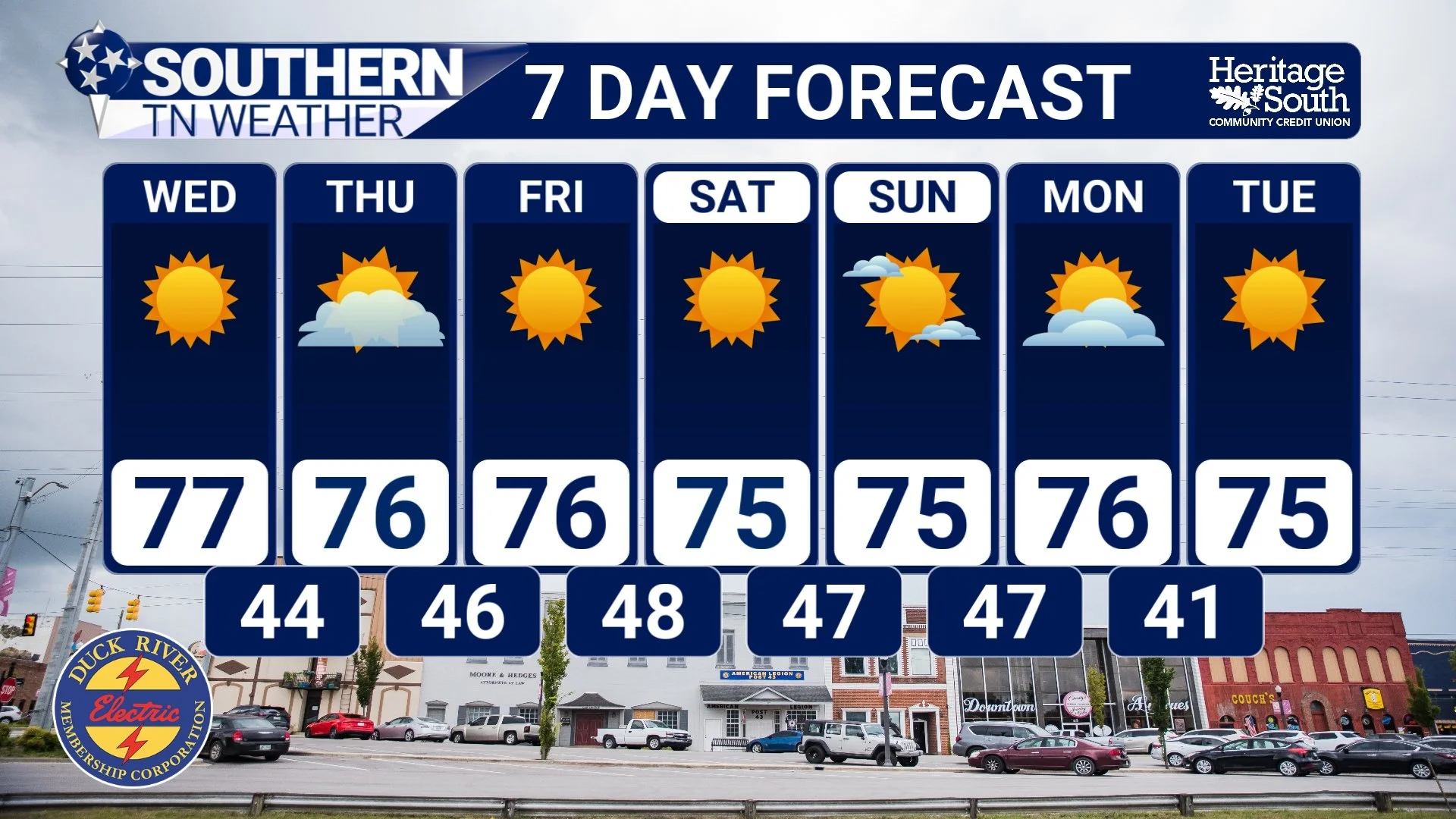
Tuesday is shaping up to be another beautiful autumn day, with mostly sunny skies and afternoon highs generally in the middle to upper 70s. Relative humidity values may fall into the 25–30% range in some locations, especially during the warmest part of the afternoon. Winds should remain relatively light, but the combination of dry air and drought-stressed vegetation will still increase fire concerns. Tonight will be clear and chilly, with temperatures falling into the lower and middle 40s.
Wednesday and Thursday will bring more of the same, with mostly sunny skies, comfortable afternoon temperatures in the middle to upper 70s, and chilly overnight lows generally in the 40s. Some passing clouds will be possible at times, but no meaningful rainfall is expected. High pressure will continue influencing our weather through Friday and the upcoming weekend, keeping conditions predominantly dry with plenty of sunshine. Afternoon temperatures should generally remain in the 70s, although some communities could approach 80 degrees. Overnight lows will continue falling into the 40s, providing that familiar autumn contrast between chilly mornings and pleasant afternoons.
Unfortunately, there's very little indication of a significant pattern change heading into early next week. And while that may sound wonderful for outdoor activities, it comes with an increasingly important downside.
Fire danger is becoming a growing concern across Southern Middle Tennessee. Afternoon relative humidity values will frequently drop into the 25–40% range, and our ongoing drought means grasses, fallen leaves, and other vegetation are becoming increasingly dry. Even without particularly strong winds, fires can ignite and spread more easily when vegetation and the surrounding atmosphere are this dry. The National Weather Service is specifically highlighting elevated fire danger through the remainder of the week and potentially into the weekend.
This doesn't necessarily mean we're expecting widespread wildfires or extreme fire-weather conditions, but it does mean everyone should be especially cautious with outdoor burning, discarded cigarettes, equipment that produces sparks, and other potential ignition sources. I'd strongly recommend avoiding outdoor burning until we receive meaningful rainfall and conditions become more favorable. Unfortunately, drought conditions are expected to continue worsening across Tennessee as this persistent dry pattern continues.
So, while the forecast looks absolutely BEAUTIFUL for spending time outdoors, there's a growing downside to all this sunshine. We desperately need a change in our weather pattern that can bring several rounds of beneficial rainfall, and right now, there simply isn't much evidence of that happening anytime soon.
The Bottom Line 🧾
💧 Dew doesn't fall from the sky like rain. It forms directly on surfaces when water vapor condenses as those surfaces cool.
🌡️ The dew point matters. Dew can form when a surface cools to or below the dew point of the surrounding air.
🌙 Clear skies and light winds promote radiational cooling, which can help grass, leaves, and windshields become cold enough for dew to develop.
🍂 Autumn is especially favorable for dew formation because longer nights allow more time for cooling, although sufficient moisture is still necessary.
🌿 Grass can be wet while pavement stays dry because different surfaces absorb, store, and release heat at different rates.
❄️ Dew and frost aren't the same. Dew is liquid water, while frost consists of ice crystals. Frost can develop even when the official air temperature remains above freezing.
🌵 Morning dew won't end our drought. The moisture involved is generally far too limited to replenish dry soils or meaningfully improve drought conditions.
☀️ This week's forecast: Mostly sunny skies, highs in the 70s, and chilly overnight lows in the 40s.
🔥 Fire danger is increasing. Very dry air, low afternoon humidity, and drought-stressed vegetation will make outdoor burning increasingly risky.
🌧️ No meaningful rainfall is expected over the next seven days, and drought conditions will likely continue worsening.
📰 Reminder: The Southern Tennessee Weather Blog, presented by Heritage South Community Credit Union, is updated Monday through Friday with fresh, locally tailored forecasts you can trust.
