

The Southern Tennessee Weather Blog is proudly presented by Heritage South Community Credit Union.
We Help When Others Won’t!
Visit https://www.heritagesouth.org/ today to see how HSCCU can help YOU!
HAPPY HALLOWEEN EVE! After more than two weeks of sunshine, unusually warm temperatures, and very little meaningful rainfall, our stubborn weather pattern is FINALLY beginning to change across Southern Middle Tennessee! And wouldn't you know it, the first system to break our dry spell has decided to show up during Halloween weekend. Talk about some unfortunate timing!
But before you start canceling those trick-or-treating plans, I've actually got some GOOD NEWS! The latest forecast guidance continues to suggest that much of Halloween will remain dry, with the better opportunity for widespread rainfall holding off until Saturday night and Sunday. That's certainly an encouraging development for everyone planning to get outside and enjoy the festivities! However, this weekend's weather will be noticeably different from what we've experienced throughout much of October. Clouds will become increasingly widespread, winds will begin picking up, and we'll finally see some meaningful moisture returning to our atmosphere. By Sunday, periods of rainfall are expected across much of Southern Middle Tennessee, potentially providing our first widespread soaking rain in quite some time.
And believe it or not, this weekend's system may only be the beginning of a more active weather pattern as we head into November!
Halloween: Will the Rain Hold Off for Trick-or-Treating?
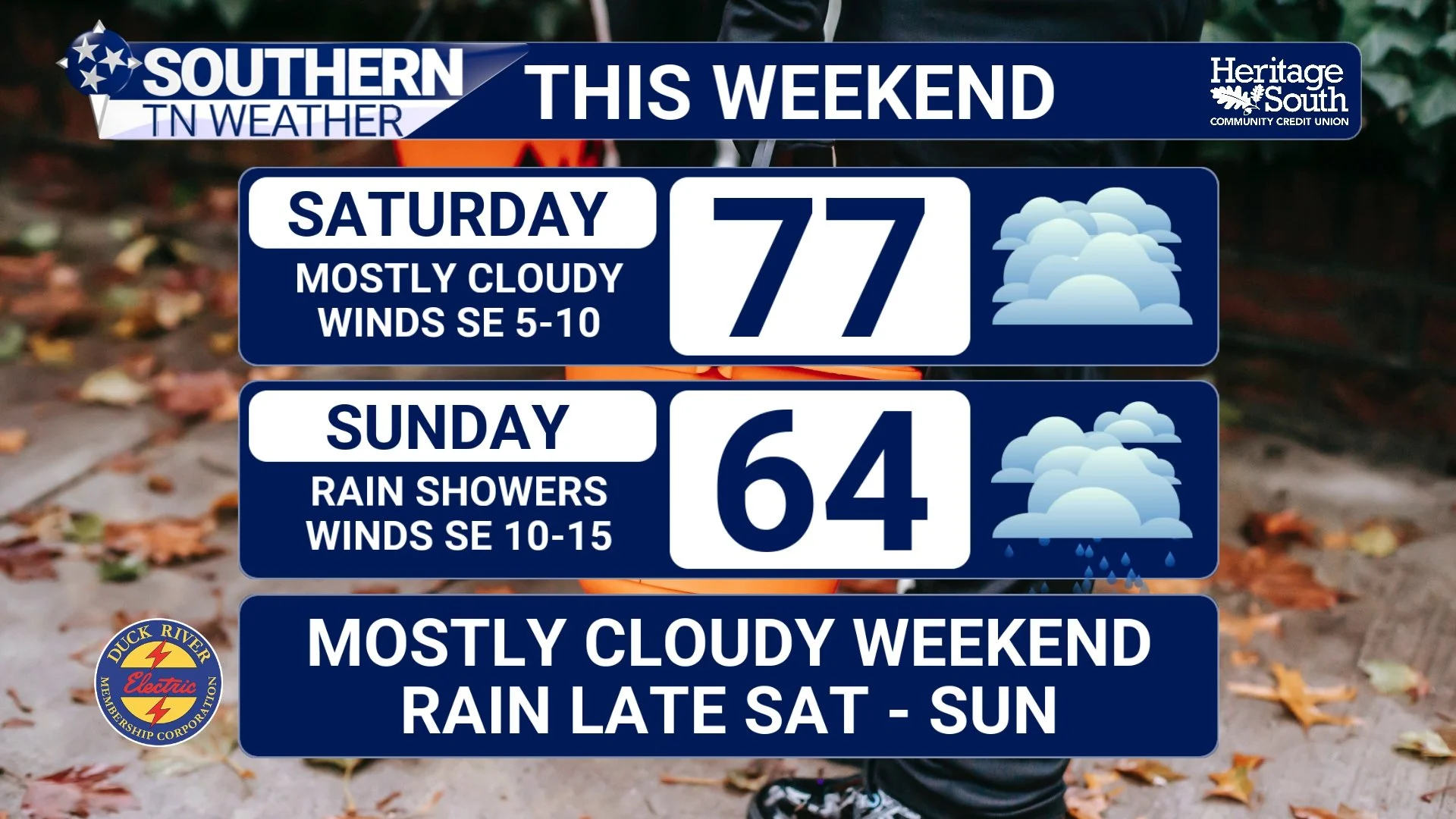
Let's start with the question EVERYONE has been asking. Will Halloween be a washout? THE ANSWER IS NO! At least, that's not what the latest forecast guidance is suggesting. Saturday will begin with mostly cloudy skies across Southern Middle Tennessee, with temperatures gradually warming into the lower to middle 70s during the afternoon. Some of our warmer communities could climb into the upper 70s, particularly where cloud cover is a little thinner.
Now, here's where things get interesting. As our approaching weather system draws closer, atmospheric moisture will continue increasing, and a few patches of light rain or isolated showers could begin developing during the late afternoon and evening hours. However, the latest guidance suggests that widespread rainfall should hold off until later Saturday night. In fact, I'm becoming increasingly confident that much of our coverage area will remain MOSTLY DRY through the traditional trick-or-treating hours!
That doesn't mean I can completely rule out rainfall. A few isolated showers or patches of drizzle could develop, especially across our southern and southwestern communities. Areas closer to the Alabama state line, including portions of Franklin and Lincoln counties, may have a somewhat greater opportunity to see showers arriving earlier. But for most communities, I expect dry periods to outweigh wet periods during the early evening hours. Temperatures should also be relatively comfortable for Halloween festivities. We're expecting readings in the upper 60s to lower 70s around sunset, gradually falling through the 60s as the evening progresses. That's certainly not too shabby for the final day of October!
One thing you may notice, however, is an increase in wind speeds. East-to-southeast winds will strengthen as the pressure gradient tightens ahead of our approaching weather system. Sustained winds could reach 10–20 MPH in some locations, with occasional gusts approaching 25–30 MPH, especially across our southern counties and higher elevations. So, if you've got lightweight Halloween decorations sitting outside, you might want to make sure they're secured! The bottom line for Halloween is pretty simple. KEEP YOUR PLANS! I certainly wouldn't cancel trick-or-treating over the current forecast. Just keep an umbrella or rain jacket nearby in case one of those isolated showers happens to pass through your neighborhood.
Saturday Night Into Sunday: The Rain FINALLY Returns!
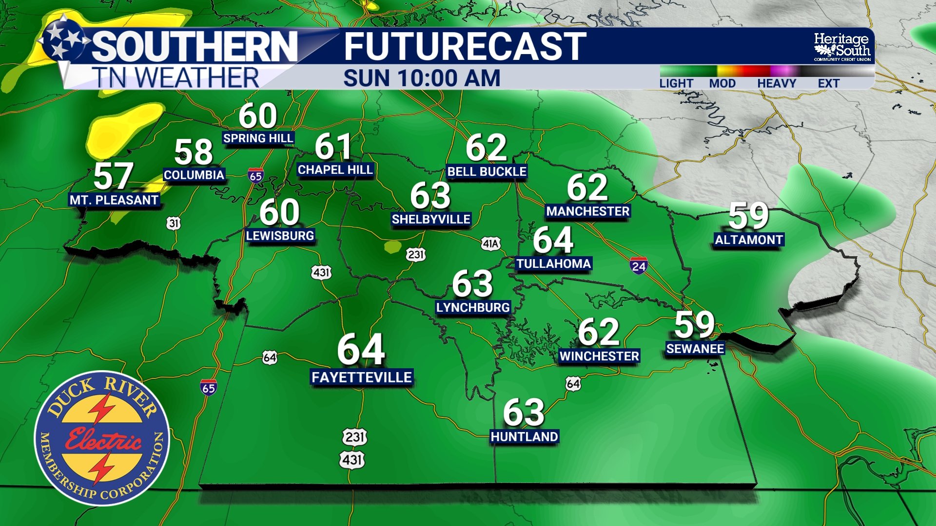
Unfortunately, our mostly dry Halloween weather won't last much longer. As we head into Saturday night, an approaching disturbance in the upper atmosphere will begin interacting with increasing moisture moving northward from the Gulf of Mexico. This will create a much more favorable environment for widespread cloud development and precipitation. Rain chances should gradually increase during the evening and overnight hours, with the most widespread rainfall expected to develop after midnight and continue into Sunday morning.
Sunday is shaping up to be a rather gloomy day compared to the beautiful autumn weather we've enjoyed recently. Widespread cloud cover will dominate, with periods of rain continuing through the morning and into the afternoon. Now, I want to emphasize that THIS DOESN'T NECESSARILY MEAN IT WILL RAIN EVERY SINGLE MINUTE OF SUNDAY! There will likely be some breaks in the precipitation, particularly as the system gradually moves across the region. However, I do expect wet periods to be considerably more common than dry ones throughout much of the day.
A few embedded thunderstorms are also possible, although the overall atmosphere doesn't appear particularly favorable for organized severe weather. Instability is expected to remain relatively limited, which should help keep the threat of strong or severe thunderstorms quite low. Temperatures will be noticeably cooler as well. Instead of the upper 70s and lower 80s we've experienced recently, afternoon highs Sunday should generally remain in the 60s. Combine those cooler temperatures with widespread clouds, occasional rainfall, and a steady breeze, and it's going to feel like a completely different season!
Rainfall should gradually become less widespread Sunday afternoon and evening as our first weather system begins moving away from Southern Middle Tennessee. Some lingering showers may continue into the evening, but the overall trend should be toward improving conditions overnight.
How Much Rainfall Are We Actually Expecting?
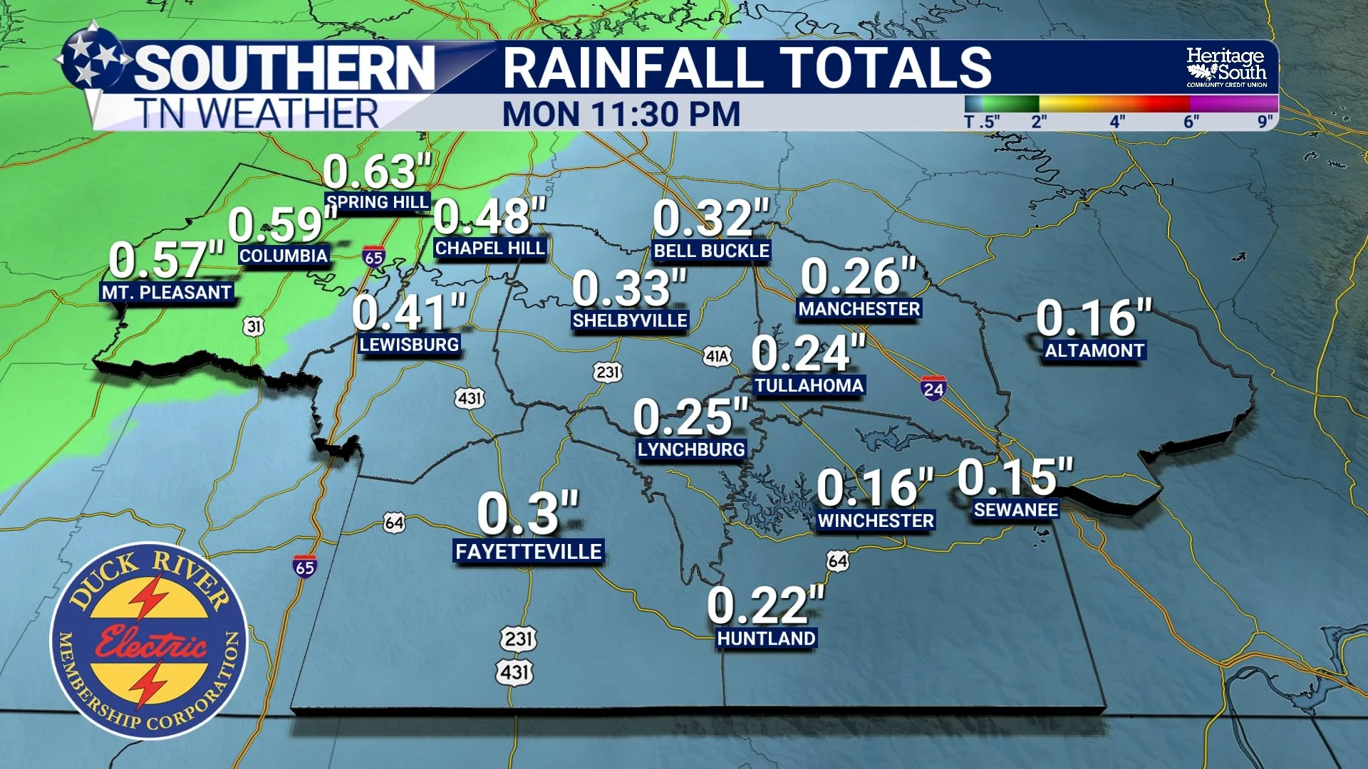
Now, let's talk about the BIG question. How much rain are we going to receive? Considering how rapidly our drought has worsened over the past several weeks, I know many of you are hoping for a widespread soaking rainfall. And while this weekend's system should provide some beneficial precipitation, I want to make sure we're keeping our expectations realistic. Right now, I'm generally expecting rainfall totals around 0.25–0.50 inches across much of Southern Middle Tennessee through Sunday night, although some communities could receive higher amounts depending on where the more persistent rainfall develops.
A few locations could approach or exceed one inch if heavier showers become established, but I don't expect those higher totals to be widespread. There may also be a noticeable difference in rainfall amounts from west to east. Communities across Maury, Marshall, and western Bedford counties could have a somewhat better opportunity for higher totals, while locations farther east, particularly across the Cumberland Plateau, may receive considerably less. Of course, these totals remain subject to change as the exact track and intensity of the approaching system become clearer.
And while any rainfall would certainly be welcome, THIS WEEKEND'S RAIN IS NOT GOING TO END OUR DROUGHT! As we discussed in yesterday's blog, D3 Extreme Drought has expanded across substantial portions of Southern Middle Tennessee. Those conditions have developed because of accumulated rainfall deficits over an extended period, and one relatively modest rainfall event isn't going to erase those deficits overnight.
However, even a quarter-inch or half-inch of rain could provide some temporary relief for dry vegetation and help replenish moisture in the upper layers of soil. It may also help slow further deterioration in areas that have experienced particularly dry conditions. But to make meaningful progress against our ongoing drought, we're going to need additional rainfall. And thankfully, there may be another opportunity just around the corner!
Another, Potentially STRONGER Weather System Next Week?
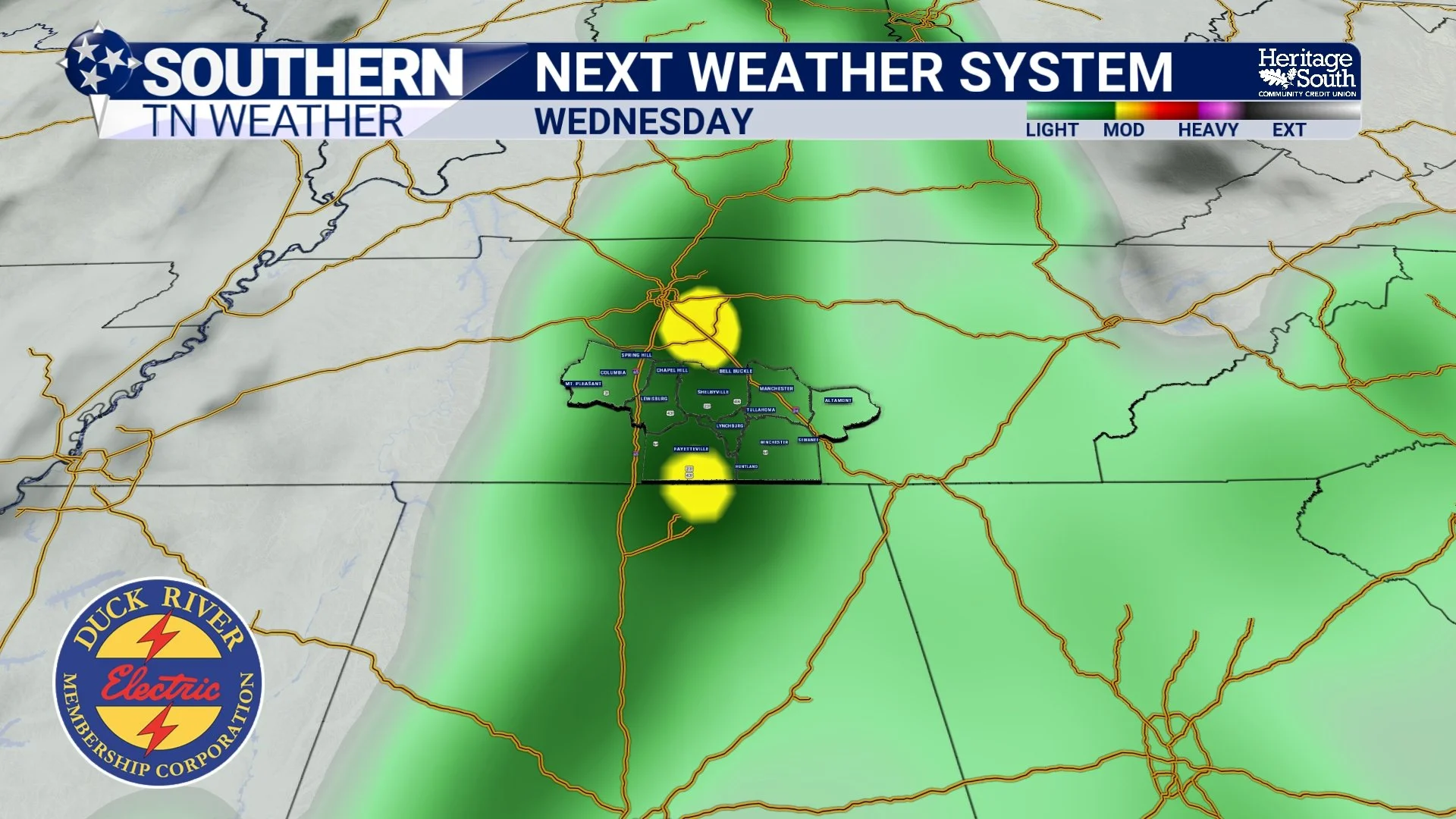
Believe it or not, our weekend rainfall may only be the first chapter in a much more active weather pattern! After our first system moves away Sunday evening, high pressure should briefly return to the region, allowing conditions to improve Monday and potentially much of Tuesday. Temperatures should rebound into the 70s, with some sunshine returning as the atmosphere temporarily settles down. However, another disturbance is expected to develop across the central United States and eventually move toward our region during the middle of next week.
And this second system could be considerably more substantial than the one we're expecting this weekend. Current guidance suggests that a stronger, slower-moving upper-level disturbance may help organize a larger area of precipitation across portions of the Southeast. If sufficient moisture becomes established ahead of the system, we could see a more widespread soaking rainfall across Southern Middle Tennessee. At this point, Wednesday appears to be one of the more favored periods for widespread precipitation, although the exact timing remains uncertain.
What's particularly encouraging is that some of the latest probabilistic guidance is showing a relatively high likelihood of receiving at least an inch of rainfall with this second system across portions of Middle Tennessee. There are even some scenarios suggesting locally higher totals. Now, before we get TOO excited, remember what we discussed in Tuesday's weather blog about computer models! We're still several days away, and differences in the track, strength, and timing of this system could significantly influence rainfall totals.
There's also some uncertainty regarding how quickly the system will organize and move eastward. Some guidance has trended toward a slower arrival, which could delay the better rainfall opportunities until later in the week. As for thunderstorms, a few could develop if enough instability becomes available. However, the overall severe weather potential currently appears limited. That's certainly encouraging, but we'll continue evaluating the atmospheric environment as the system gets closer.
The important takeaway is that WE MAY FINALLY BE TRANSITIONING INTO A MORE ACTIVE WEATHER PATTERN! And considering the drought conditions we're experiencing across Southern Middle Tennessee, that's exactly what we need to see.
Could This Be the Beginning of Meaningful Drought Relief?
This is probably the most encouraging part of our forecast. For much of October, we've been stuck beneath a persistent ridge of high pressure that has repeatedly limited our opportunities for meaningful rainfall. Even when weak disturbances moved through the region, the atmosphere remained too dry to support widespread precipitation. Now, we're beginning to see signs that this pattern is changing.
The first system arrives this weekend, potentially bringing some beneficial rainfall. Another, potentially stronger system could follow during the middle of next week. And when we look farther ahead, the latest 8–14 day outlook favors increased chances for above-normal precipitation across Tennessee during November 5–11. That's certainly an encouraging development! However, it's important to understand that a wetter forecast doesn't automatically mean drought conditions will improve immediately. Our soils have experienced prolonged moisture deficits, and some of our deeper water resources may take considerably longer to recover.
The type of rainfall we receive will also matter. A slow, steady soaking rain is generally more beneficial for replenishing soil moisture than a brief, intense downpour that produces excessive runoff. That's why I'll be watching not only how much rain falls over the next week, but also how quickly it falls and how widespread the precipitation becomes. If we can string together several beneficial rainfall events during November, we may finally begin making some meaningful progress against our worsening drought.
And after weeks of watching the rain repeatedly miss Southern Middle Tennessee, I think we're ALL ready for a change!
The Bottom Line 🧾
Friday: Increasing clouds with afternoon highs in the upper 70s to lower 80s. Dry conditions continue.
Halloween: Mostly cloudy and warm, with afternoon highs generally in the 70s. Much of the day should remain dry.
Trick-or-treating: Temperatures falling through the 60s during the evening. Isolated showers or patches of drizzle are possible, but widespread rainfall is not currently expected during the early evening hours.
Winds: East-to-southeast winds will increase Saturday, with occasional gusts of 25–30 MPH possible, especially across southern communities and higher elevations.
Saturday night: Rain chances increase, with more widespread precipitation developing overnight.
Sunday: Periods of rainfall are expected, particularly during the morning and midday hours. Highs generally in the 60s.
Thunderstorms: A few rumbles of thunder are possible, but organized severe weather is not expected with the weekend system.
Rainfall totals: Generally 0.25–0.50 inches across much of Southern Middle Tennessee, with locally higher amounts possible. Eastern communities and the Cumberland Plateau may receive less.
Monday and Tuesday: Improving conditions with a temporary return to drier weather and afternoon highs in the 70s.
Middle of next week: Another, potentially stronger system could bring more widespread and substantial rainfall, particularly around Wednesday.
Drought relief: This weekend's rainfall alone won't eliminate our drought, but multiple rainfall opportunities could finally help us begin making progress.
📰 Reminder: The Southern Tennessee Weather Blog, presented by Heritage South Community Credit Union, is updated Monday through Friday with fresh, locally tailored forecasts you can trust
