
Why Do Weather Models Disagree SO MUCH? Here's Why Forecasting Rain Isn't as Easy as You Think!

The Southern Tennessee Weather Blog is proudly presented by Heritage South Community Credit Union.
We Help When Others Won’t!
Visit https://www.heritagesouth.org/ today to see how HSCCU can help YOU!
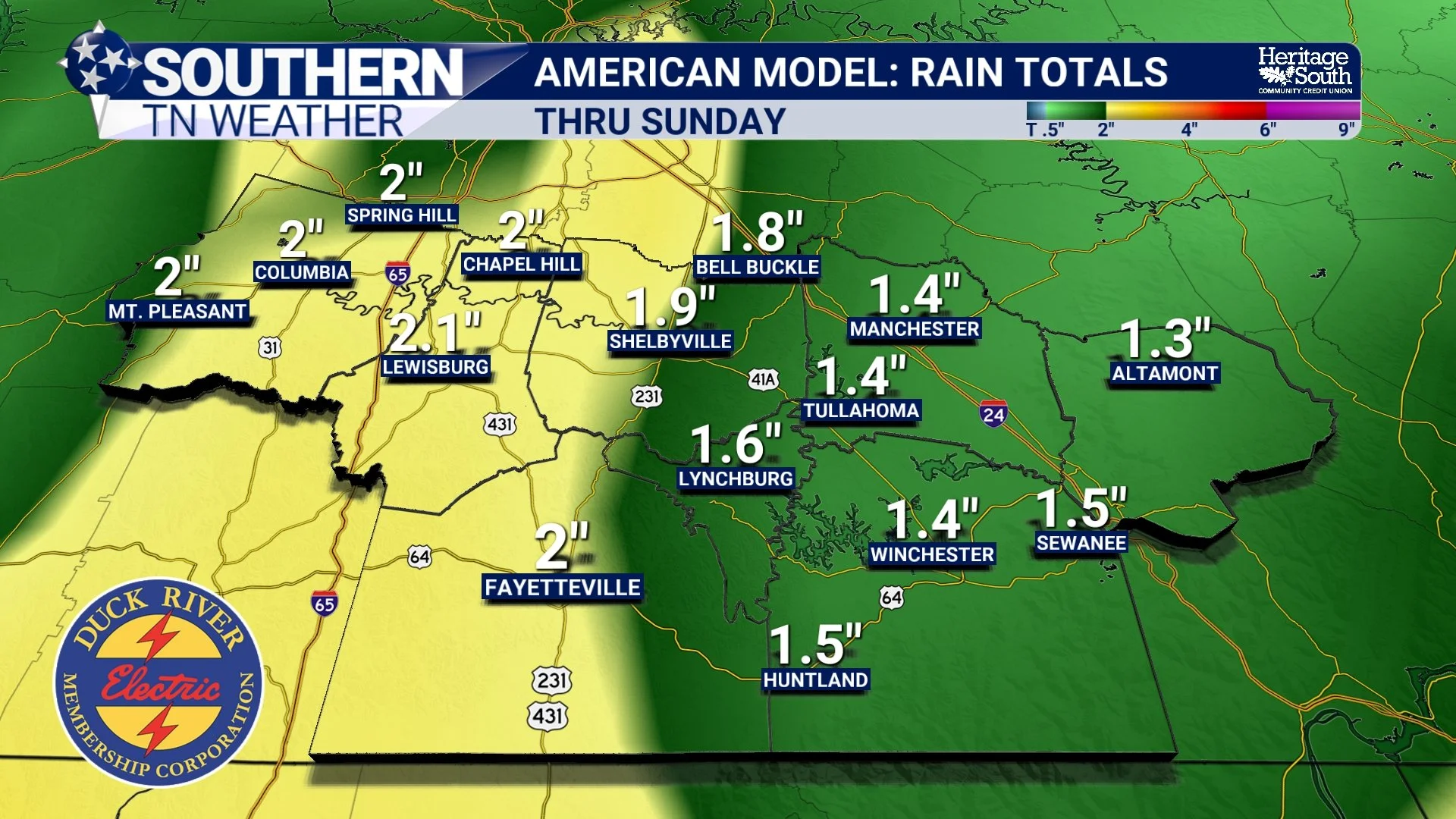
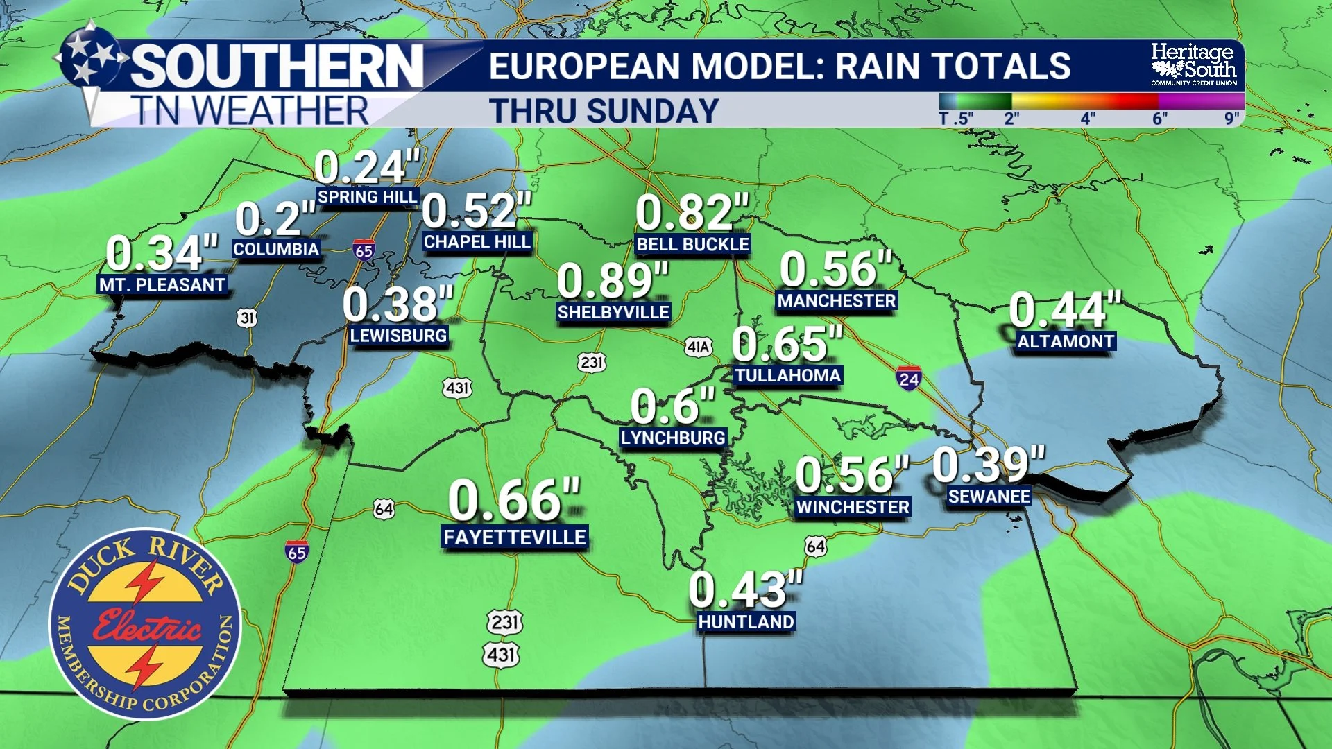
HAVE YOU EVER WONDERED WHY TWO COMPUTER MODELS CAN SHOW COMPLETELY DIFFERENT WEATHER FORECASTS FOR THE EXACT SAME DAY? One model might show two inches of rainfall across Southern Middle Tennessee, while another barely shows enough to wet the pavement. One might bring a storm system through Saturday afternoon, while another holds it off until Sunday morning. And somehow, BOTH models are attempting to predict the exact same atmosphere! It sounds a little ridiculous, doesn't it? Well, with our first meaningful rain chances in more than two weeks potentially approaching this weekend, I figured today would be the PERFECT opportunity to discuss one of the most fascinating, and sometimes frustrating, aspects of meteorology: WHY COMPUTER WEATHER MODELS DISAGREE!
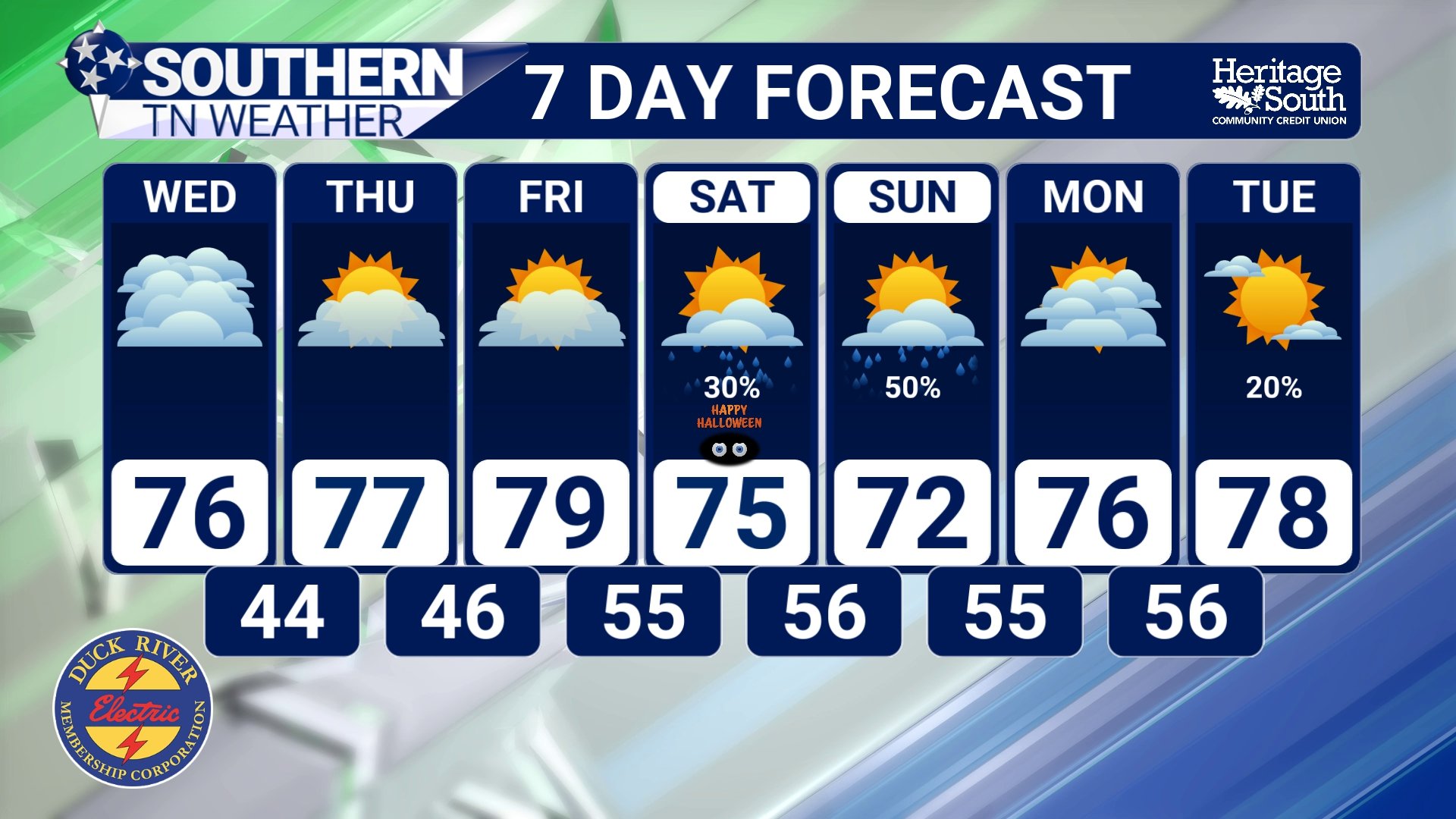
Before we dive into the science, let's briefly discuss today's weather. We're enjoying another beautiful fall day across Southern Middle Tennessee, with a mixture of sunshine and clouds and temperatures climbing into the middle to upper 70s. More pleasant weather is expected through the remainder of the workweek, with afternoon highs potentially approaching 80 degrees by Thursday and Friday. Unfortunately, our ongoing drought isn't going anywhere just yet, with dry conditions expected through at least Friday night.
However, our stubborn weather pattern is beginning to show signs of changing. Rain chances are expected to return this weekend, with the better opportunities currently looking to arrive Saturday night into Sunday. And THAT'S where today's discussion becomes particularly relevant. With Halloween approaching, computer models are beginning to show a more unsettled weather pattern developing across our region, but there are still differences regarding the timing, placement, and amount of rainfall. So, why can't these incredibly sophisticated computer models simply agree on what's going to happen?
First, What Exactly IS a Computer Weather Model?
When meteorologists talk about the American model, European model, or any other computer forecast model, we're referring to something called a Numerical Weather Prediction (NWP) model. Essentially, these are incredibly sophisticated computer programs that use mathematical equations to simulate how the atmosphere is expected to evolve over time. And when I say sophisticated, I mean REALLY sophisticated!
The atmosphere is constantly changing. Air is moving horizontally and vertically, temperatures are fluctuating, moisture is being transported from one region to another, and atmospheric pressure is continuously adjusting. All these processes interact with one another, creating the weather we experience every single day. Computer models attempt to simulate those interactions using equations based on the fundamental laws of physics, including the conservation of mass, energy, and momentum.
To accomplish this, a computer model divides the atmosphere into an enormous three-dimensional grid containing millions of individual points or cells. At each location, the model represents atmospheric conditions such as temperature, pressure, wind, and moisture. It then uses mathematical calculations to estimate how those conditions will change over time. Those calculations are repeated again and again as the simulation moves forward into the future, eventually producing the colorful forecast maps you've probably seen shared across social media. But there's one BIG problem. THE ATMOSPHERE IS INCREDIBLY COMPLICATED, AND WE CAN'T MEASURE EVERY SINGLE PART OF IT PERFECTLY!
Problem #1: We Don't Know EXACTLY What's Happening Everywhere!
Before a computer model can predict what the atmosphere will do tomorrow, it first needs to know what's happening RIGHT NOW. Meteorologists refer to this as the initial state of the atmosphere. To estimate that initial state, forecasting systems collect enormous amounts of information from weather stations, weather balloons, satellites, aircraft, ocean buoys, radar systems, and other observing networks. However, despite all our technological advancements, there are still significant gaps in our observations. We have relatively dense networks of weather stations across populated areas of the United States, but what about the middle of the Pacific Ocean? What about remote mountain ranges? Or atmospheric conditions thousands of feet above regions with very few weather observations? We simply cannot measure every single part of the atmosphere.
Instead, models use a process called data assimilation to combine available observations with information from previous forecasts and estimate the most likely current atmospheric conditions. Different forecasting systems use different methods to accomplish this, and even small differences in those initial conditions can eventually lead to noticeably different forecasts.
Think about it this way. Imagine two people trying to predict where a leaf floating down a river will end up. Both know the general direction of the current, but one estimates the leaf's starting position just a few inches differently. At first, their predictions might look nearly identical. But as the leaf encounters different currents and obstacles, those small differences could eventually lead to completely different outcomes. The atmosphere behaves in a somewhat similar way, although the physics involved are considerably more complicated. A SMALL DIFFERENCE IN TODAY'S ATMOSPHERIC CONDITIONS CAN SOMETIMES BECOME A MUCH BIGGER DIFFERENCE SEVERAL DAYS DOWN THE ROAD!
Problem #2: The Atmosphere Is CHAOTIC!
Have you ever heard of the Butterfly Effect? It's a concept commonly associated with meteorologist and mathematician Edward Lorenz, whose research helped establish the foundations of chaos theory. The basic idea is that certain complex systems are extremely sensitive to their starting conditions. Very small differences in the initial state can eventually produce substantially different outcomes. And our atmosphere is one of those systems! Now, this doesn't mean a butterfly flapping its wings literally causes a tornado somewhere else. That's a popular oversimplification of the concept. What it DOES mean is that the atmosphere contains countless interacting processes, and tiny differences in those processes can grow over time.
For example, imagine a developing storm system moving across the central United States. One computer model might predict that an upper-level disturbance will strengthen slightly faster than another model predicts. That small difference could influence the development of a surface low-pressure system, the direction of the winds, and the amount of moisture transported northward. Several days later, one model might bring widespread rainfall into Southern Middle Tennessee on Saturday afternoon, while another delays the heaviest precipitation until Sunday morning. Both forecasts may have started with atmospheric conditions that were extremely similar!
This is one reason FORECAST CONFIDENCE GENERALLY DECREASES THE FARTHER INTO THE FUTURE WE LOOK. Modern computer models are remarkably good at identifying many large-scale weather patterns well in advance, but predicting the general arrival of a storm system is often easier than determining the exact hour rainfall will begin in Shelbyville, Tullahoma, Winchester, or Columbia. And when we're talking about Halloween festivities, a difference of just SIX HOURS could be a pretty big deal!
Problem #3: The American and European Models Aren't Built Exactly the Same!
Now, let's talk about two of the most recognizable computer models in meteorology: the American GFS, which stands for Global Forecast System, and the European ECMWF forecasting system, commonly referred to as the European model. Both are global numerical weather prediction systems designed to simulate atmospheric conditions across the planet, but they don't operate in exactly the same way. Each system uses its own combination of numerical methods, atmospheric physics, data assimilation techniques, and methods for representing processes that are too small to calculate directly. Remember how we discussed computer models dividing the atmosphere into a three-dimensional grid? Well, even the most advanced forecasting systems cannot explicitly simulate every individual cloud droplet, turbulent air current, or small-scale atmospheric interaction.
To account for these smaller processes, models use mathematical approximations called parameterizations. These help represent things like cloud formation, convection, radiation, and exchanges of heat and moisture between the ground and atmosphere. Different models handle these processes differently, which can eventually influence the predicted location, timing, and intensity of precipitation.
So, WHICH MODEL IS BETTER? That's a question I get ALL THE TIME! And the answer isn't quite as simple as declaring one model the winner. Some forecasting systems perform better than others for certain variables, geographic regions, and forecast periods. While the European forecasting system has historically demonstrated strong performance in many medium-range forecasting situations, that doesn't mean it will outperform every other model during every individual weather event. Likewise, the American GFS can sometimes identify important developments that other models struggle to resolve.
That's why professional meteorologists generally don't rely on just ONE computer model. We compare multiple sources of guidance, examine their strengths and weaknesses, and use our understanding of atmospheric science to determine which solutions appear most realistic. Because here's something I want everyone to understand: A COMPUTER MODEL IS A FORECASTING TOOL. IT IS NOT THE FORECAST ITSELF!
Why Are Rainfall Totals Especially Difficult to Predict?
Now, let's get into something that's particularly relevant to our current situation. RAINFALL TOTALS! You've probably seen those colorful computer-model maps showing projected rainfall accumulations over the next several days. Some show widespread areas of green, yellow, orange, and red, representing increasingly significant rainfall totals. And after more than two weeks without meaningful rainfall across Southern Middle Tennessee, I completely understand why people get excited when those maps start showing a couple of inches of rain!
But here's the problem. RAINFALL TOTALS ARE OFTEN ONE OF THE MORE DIFFICULT DETAILS TO PREDICT SEVERAL DAYS IN ADVANCE. There are several reasons for this. First, the exact track of an approaching weather system can dramatically influence where the greatest rainfall occurs. If a developing low-pressure system tracks slightly farther north, the heaviest precipitation might remain displaced from Southern Middle Tennessee. If it tracks farther south, our region could end up closer to the most favorable area for widespread rainfall.
Second, the amount of atmospheric moisture available makes a tremendous difference. A storm system moving into a relatively dry atmosphere may struggle to produce significant precipitation, even if the upper-level disturbance itself is fairly strong. On the other hand, a system with access to abundant Gulf moisture could produce considerably more rainfall. The speed of the weather system also matters. A fast-moving system may produce a relatively brief period of rain, while a slower-moving system could allow precipitation to continue over a longer period. And finally, the development of individual showers and thunderstorms can create substantial differences in rainfall totals over relatively short distances.
That's why I encourage everyone to be VERY cautious when sharing individual computer-model rainfall maps several days before a potential event. A model showing two inches of rainfall over Bedford County doesn't mean Bedford County is guaranteed to receive two inches of rainfall. It simply means that particular model simulation produced that amount based on its representation of the atmosphere at that forecast time.
So, How Do Meteorologists Figure Out Which Model to Trust?
Rather than simply choosing whichever model shows the most exciting weather, meteorologists examine several different factors. One of the first things we look for is CONSISTENCY. Has a model been showing a similar solution over several consecutive forecast runs? Or does it keep changing the timing and location of the approaching system? Consistency can be encouraging, although it doesn't automatically mean a model is correct. We also look for AGREEMENT BETWEEN DIFFERENT MODELS. If several independent forecasting systems begin showing a similar atmospheric pattern, that can increase our confidence that the general scenario is becoming more likely. However, agreement doesn't guarantee accuracy either. Different models can sometimes share similar biases or respond similarly to errors in their initial conditions.
Another important consideration is whether the model solution makes sense meteorologically. For example, if a model predicts widespread heavy rainfall across Southern Middle Tennessee while simultaneously showing very limited atmospheric moisture and weak upward motion, that would raise some questions. We would want to investigate whether the model's precipitation forecast is supported by the larger-scale atmospheric environment. And perhaps most importantly, we examine something called ENSEMBLE FORECASTING. This is one of the most valuable tools we have for understanding uncertainty.
Imagine you're trying to predict what the weather will look like this Saturday. Instead of running a computer model just once, what if you ran it dozens of times, each with slightly different initial conditions or representations of atmospheric processes? That's essentially the idea behind ensemble forecasting! An ensemble forecasting system produces multiple simulations of the atmosphere, with each simulation called an ensemble member. If nearly every ensemble member predicts a similar storm track and timing, that generally suggests greater confidence in the overall forecast. But if some members bring widespread rainfall into Southern Middle Tennessee Saturday afternoon, others delay it until Sunday, and several keep most of the precipitation away from our region entirely, that tells us something VERY important: THERE'S STILL CONSIDERABLE UNCERTAINTY!
Ensembles can also help us estimate the probability of certain events, such as receiving at least a quarter-inch or one inch of rainfall. Rather than relying on one individual model run, we can examine a broader range of possible outcomes and determine which scenarios appear most likely.
What Does All This Mean for Halloween Weekend?
Now that we've covered the science, let's bring everything back home to Southern Middle Tennessee. Our stubborn ridge of high pressure is expected to maintain generally dry conditions through the remainder of the workweek. However, the larger-scale atmospheric pattern is expected to become more favorable for unsettled weather as we approach the weekend. An approaching upper-level disturbance, increasing atmospheric moisture, and the potential development of a secondary surface low-pressure system could help bring showers back into our region. At this point, rain chances are expected to begin increasing Saturday, with better opportunities Saturday night and into Sunday.
But there are still some important details that need to be resolved. How quickly will the system approach? How much moisture will return? Where will the strongest atmospheric lift develop? And perhaps most importantly, will this system produce enough rainfall to provide meaningful drought relief? One encouraging development is that the potential for unsettled weather may not end with this weekend. Another weather system could approach early next week, potentially providing additional opportunities for rainfall. However, the timing and impacts of that second system remain uncertain.
The important takeaway is that we're becoming more confident in the possibility of a BROADER PATTERN CHANGE, even though the specific rainfall amounts and timing are still coming into focus. And that's a perfect example of why computer models can agree on the BIG picture while continuing to disagree on the smaller details.
Before we wrap things up, I want to address something that occasionally frustrates people. You might see a forecast showing rain Saturday afternoon, only to check again the next morning and discover that the better rain chances have shifted to Saturday night. Does that mean the forecast was wrong? Not necessarily! Weather forecasting is a continuous process of updating predictions as new observations become available. Every day, weather balloons are launched, satellites collect new measurements, radar systems monitor developing precipitation, and computer models incorporate additional atmospheric information. As we get closer to a potential weather event, that new information can help narrow the range of possible outcomes.
A CHANGING FORECAST DOESN'T NECESSARILY MEAN METEOROLOGISTS DON'T KNOW WHAT THEY'RE DOING. IT OFTEN MEANS WE'RE LEARNING MORE ABOUT WHAT THE ATMOSPHERE IS ACTUALLY GOING TO DO! Of course, forecasts can absolutely be wrong, and meteorologists should be willing to acknowledge those misses. But there's an important difference between an inaccurate forecast and a forecast that becomes more precise as an event approaches. Our goal is to communicate what we know, what remains uncertain, and how our confidence changes as new information becomes available.
The Bottom Line 🧾
Different models can begin with slightly different estimates of current conditions, which can lead to increasingly different forecasts over time.
The atmosphere is chaotic! Small differences in initial conditions can eventually produce significant differences in storm tracks, timing, and rainfall amounts.
The American GFS and European ECMWF models use different forecasting techniques, and neither model is guaranteed to be correct during every weather event.
Rainfall totals are particularly difficult to predict several days in advance, especially when the exact storm track and moisture availability remain uncertain.
Ensemble forecasting helps meteorologists evaluate multiple possible outcomes, rather than relying on one individual model run.
Rain chances are expected to return around Halloween, with better opportunities Saturday night into Sunday.
Our ongoing drought continues to worsen in the meantime, and the amount of potential relief from the upcoming systems remains uncertain.
Another weather system could approach early next week, potentially bringing additional opportunities for rainfall.
📰 Reminder: The Southern Tennessee Weather Blog, presented by Heritage South Community Credit Union, is updated Monday through Friday with fresh, locally tailored forecasts you can trust.
