
How Do We FINALLY Break This Stubborn Weather Pattern? Here's What Has to Happen!

The Southern Tennessee Weather Blog is proudly presented by Heritage South Community Credit Union.
We Help When Others Won’t!
Visit https://www.heritagesouth.org/ today to see how HSCCU can help YOU!
IT'S AN ABSOLUTELY BEAUTIFUL MONDAY ACROSS SOUTHERN MIDDLE TENNESSEE! We're kicking off the final week of October with another pleasant autumn afternoon, featuring a mixture of sunshine and clouds and temperatures climbing into the 70s. And believe it or not, this remarkably consistent weather pattern isn't finished with us just yet! We're expecting more pleasant conditions through much of the workweek, with afternoon highs potentially warming into the lower 80s by Thursday and Friday. But there's one thing that's becoming increasingly frustrating... IT HAS BEEN SUPER DRY! We've now gone more than two weeks without meaningful rainfall across much of Southern Middle Tennessee, and our ongoing drought continues to worsen. At this point, I'm beginning to think Mother Nature has forgotten where she put the rain button! 😂
So, how in the WORLD can we go this long without any significant rainfall? What's keeping storm systems away from our region? And perhaps the most important question of all, WHAT DOES IT ACTUALLY TAKE TO BREAK A STUBBORN WEATHER PATTERN LIKE THIS? That's exactly what we're going to discuss in today's blog. And believe it or not, the answer involves a fascinating chain reaction that can begin thousands of miles away from Southern Middle Tennessee, sometimes over the Pacific Ocean!
First, Let's Talk About What's Keeping Us So Dry!
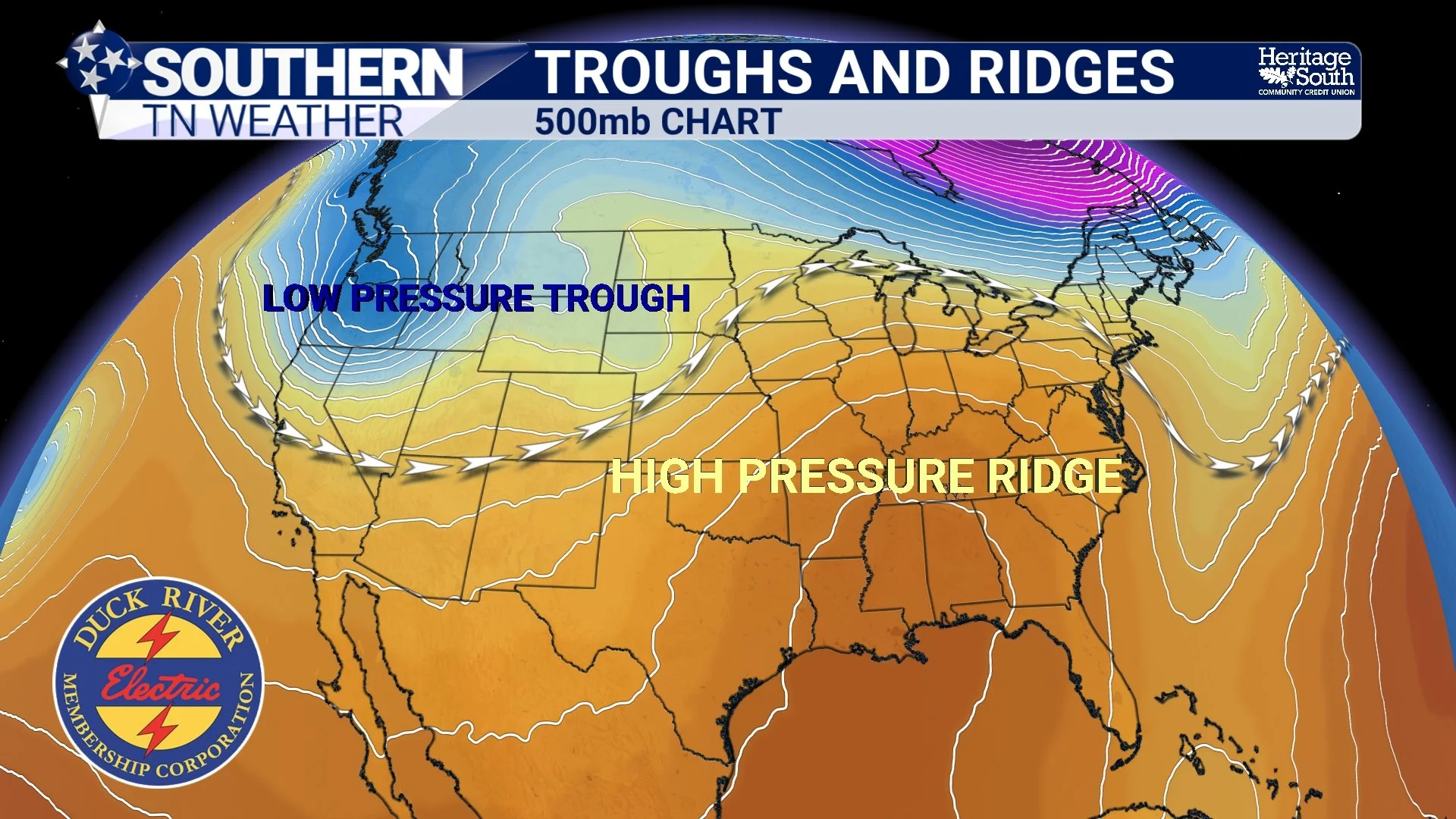
As you've probably noticed, we've been dealing with a LOT, and I mean A LOT, of sunshine and dry air recently. The primary reason involves a persistent ridge in the upper atmosphere, combined with a broad area of high pressure closer to the surface. To understand what's happening, we need to travel several miles above our heads into the middle levels of the atmosphere. One of the most useful places to examine these large-scale weather patterns is the 500-millibar pressure level, which is typically located around 18,000 feet above sea level. Now, you might be wondering why meteorologists spend so much time looking at the atmosphere nearly four miles above the ground. Well, this is where we can identify many of the large-scale features that influence how weather systems develop and move across North America. We can see ridges, troughs, and the broader atmospheric circulation that helps steer storms across the country.
And right now, one of those features has been causing us quite a few problems. It's called an upper-level ridge. A ridge gets its name from the elongated, hump-like pattern it creates on upper-air weather maps. In the Northern Hemisphere, ridges are commonly associated with a northward bulge in the atmospheric flow, while troughs generally appear as southward dips. These features are closely connected to the larger-scale circulation of the atmosphere, including the jet stream. However, a ridge isn't simply a bubble of high pressure that storms physically bounce off. Instead, it represents a region of relatively higher atmospheric heights that influences the direction of winds and the movement of weather disturbances. Ridges are also frequently associated with a process called subsidence, which is the sinking of air through the atmosphere.
As air sinks, it encounters increasing atmospheric pressure and becomes compressed. That compression causes the air to warm, which generally lowers its relative humidity. This makes widespread cloud formation more difficult because the atmosphere becomes less favorable for the sustained rising motion needed to produce clouds and precipitation. Think about what happens when we get a good summertime thunderstorm. Warm, moist air rises, cools, and eventually condenses into clouds and precipitation. Under a strong ridge, the broader atmospheric environment often works against that process by favoring sinking motion and limiting the development of organized upward motion. That's one reason ridges are commonly associated with sunny skies, relatively stable conditions, and extended periods of dry weather. And that's EXACTLY what we've been experiencing across Southern Middle Tennessee!
But Why Can't Storm Systems Just Move Through the Ridge?
Here's where things get particularly interesting. Storm systems don't necessarily move in a straight line from west to east across the United States. Their movement is strongly influenced by the larger-scale atmospheric circulation, particularly the winds in the middle and upper levels of the atmosphere. When a pronounced ridge becomes established over a region, those winds can curve around it, directing weather disturbances along different paths. Depending on the position and strength of the ridge, storm systems may track well to our north or remain displaced to our west or south. This is why we can sometimes watch active weather unfold across other parts of the country while Southern Middle Tennessee experiences absolutely NOTHING!
However, it's important to understand that a ridge doesn't necessarily destroy every storm system that approaches it. Instead, the ridge can alter the steering flow, suppress the upward motion associated with developing precipitation, or help maintain an environment that lacks sufficient moisture. Sometimes smaller disturbances can move through or around a ridge without producing much noticeable weather at the surface. Other times, the ridge is strong and persistent enough to maintain generally quiet conditions for an extended period. And that brings us to our next question.
WHY HAS THIS PARTICULAR PATTERN LASTED SO LONG? The atmosphere is constantly moving, but that doesn't mean its larger-scale circulation patterns change dramatically every day. Sometimes the arrangement of ridges and troughs becomes relatively persistent, allowing similar weather conditions to continue for days or even weeks. In our case, persistent upper-level ridging and surface high pressure have helped maintain an exceptionally dry atmosphere. Even when subtle disturbances move through the region, there simply hasn't been enough moisture or favorable atmospheric lift to produce meaningful rainfall. But thankfully, these patterns don't last forever!
It All Starts With Changes in the Jet Stream!
To understand how we can FINALLY break our stubborn weather pattern, we need to look farther upstream, often toward the western United States and the Pacific Ocean. The jet stream is a relatively narrow corridor of strong winds located high in the atmosphere. It plays an important role in guiding large-scale weather systems across North America, and changes in its configuration can have significant downstream effects. The jet stream doesn't flow in a perfectly straight line. Instead, it frequently develops large northward and southward bends associated with ridges and troughs. These large-scale atmospheric disturbances are commonly described using the concept of Rossby waves.
Rossby waves are influenced by Earth's rotation and the variation of the Coriolis effect with latitude. They help explain why the atmosphere develops broad, meandering patterns rather than simply flowing directly from west to east. Now, here's the fascinating part: Changes in the atmospheric circulation thousands of miles to our west can eventually influence our weather here in Southern Middle Tennessee!
For example, a disturbance developing over the Pacific Ocean may move toward the western United States and alter the position or strength of an existing trough. As that disturbance interacts with the larger-scale atmospheric flow, it can influence the arrangement of ridges and troughs farther downstream. Meteorologists sometimes refer to this process as downstream development. Essentially, changes occurring upstream can help trigger adjustments in the atmospheric circulation farther east. These adjustments may strengthen an existing ridge, weaken it, shift its position, or contribute to the development of a new trough.
It's almost like watching a series of waves move across a pond. The water doesn't have to travel all the way across the pond for the disturbance to influence what happens farther away. Similarly, energy and wave disturbances can propagate through the atmospheric flow, altering weather patterns downstream. Of course, the atmosphere is considerably more complicated than a pond, and not every disturbance becomes stronger as it moves east. Some weaken, some amplify, and others interact with surrounding weather systems in ways that make their evolution difficult to predict. But this is one of the fundamental ways our larger-scale weather patterns begin changing.
So, How Does a Trough Actually BREAK DOWN a Ridge?
Now we're getting to the REALLY good stuff! Let's imagine that a relatively strong trough begins developing across the western United States. Remember, a trough is an elongated area of lower atmospheric heights, often associated with cooler air aloft and a greater potential for unsettled weather. As that trough moves eastward, it can begin interacting with the ridge that's been dominating our weather pattern. Depending on the strength, orientation, and movement of these features, the approaching trough may help weaken the ridge, shift its axis farther east, or alter the larger-scale atmospheric flow enough to allow weather disturbances to move into our region. However, IT DOESN'T ALWAYS HAPPEN WITH JUST ONE TROUGH!
Sometimes an approaching disturbance is simply too weak to significantly alter a persistent ridge. It may move around the ridge, weaken as it approaches, or pass through the broader region without producing much noticeable weather. Other times, several disturbances moving through the atmospheric flow can gradually change the overall pattern. Each disturbance may contribute to adjustments in the position and strength of the ridge, eventually allowing a more substantial trough to develop or move into an area that previously experienced persistent high pressure. But I want to make one important scientific distinction here. It's not necessarily a matter of several troughs physically pushing a ridge out of the way. The atmosphere behaves as a connected fluid system, with ridges and troughs evolving through changes in wind patterns, temperature distributions, and the movement of atmospheric wave energy.
Sometimes a single strong disturbance can produce a dramatic pattern change. Other times, the transition occurs gradually as several interacting weather systems reorganize the larger-scale circulation. And occasionally, a ridge may actually become STRONGER in response to upstream changes! That's one reason forecasting the breakdown of a persistent weather pattern can be so challenging. Meteorologists aren't simply watching for a trough to approach. We're trying to determine how that trough will interact with the existing ridge and whether those interactions will be strong enough to change the weather across our region.
Those High Clouds Today? They Could Be Giving Us Some Clues!
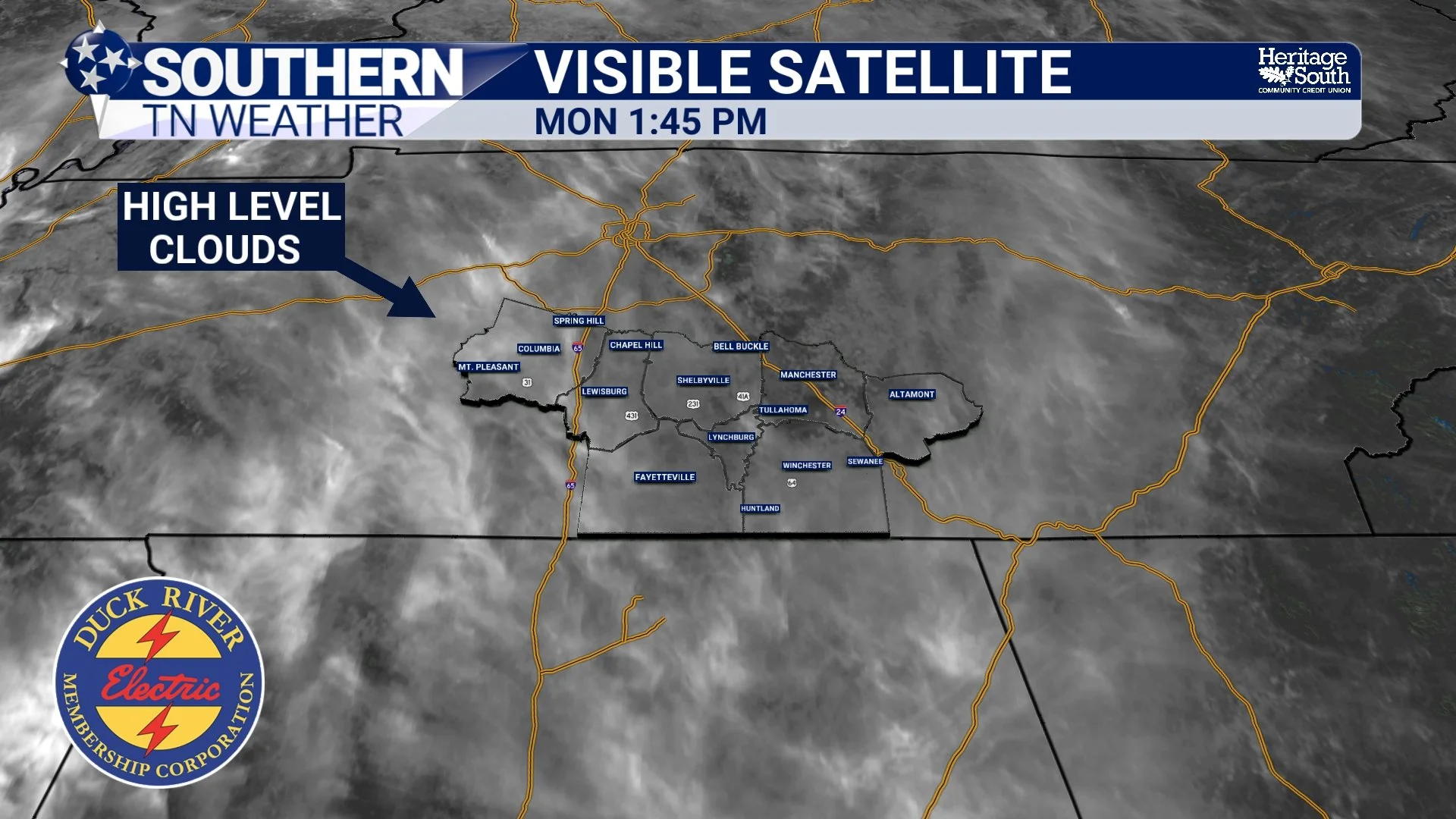
Now, let's bring this discussion back down to what we're actually seeing outside today. Have you noticed the increase in high clouds streaming across Southern Middle Tennessee? After so many days featuring nearly cloudless skies, it's certainly a noticeable change! Those clouds can tell us something interesting about what's happening in the atmosphere several miles above the ground. High clouds, including cirrus and cirrostratus, often form when moisture is present in the upper levels of the atmosphere. They can develop as air moves through regions of favorable upper-level lift, including areas associated with approaching weather disturbances or changing wind patterns.
In some situations, high clouds begin increasing well before a significant weather system reaches the surface. That's because moisture and atmospheric disturbances can arrive in the upper levels of the atmosphere before substantial changes occur closer to the ground. And that's an important part of our current situation. While the lower levels of the atmosphere remain exceptionally dry, subtle changes in the upper-level flow can allow additional moisture to move overhead. This may produce increasing high clouds even while conditions at the surface remain dry and relatively unchanged. However, high clouds alone DO NOT guarantee that rainfall is coming!
Sometimes high clouds simply represent moisture moving through the upper atmosphere without any significant disturbance capable of producing precipitation. Other times, they may be associated with a weather system that ultimately passes too far away to affect our region. In fact, it's entirely possible to have increasing cloud cover thousands of feet above the ground while the atmosphere closer to the surface remains far too dry to support measurable rainfall. That's why we have to look at the entire atmospheric profile rather than relying on cloud cover alone.
Still, the appearance of more high clouds is a useful reminder that the atmosphere is never completely stagnant. Even during an extended dry pattern, changes are constantly occurring above our heads. And as we approach the upcoming weekend, those changes could become increasingly important.
What Happens to Atmospheric Pressure When a Ridge Begins Weakening?
Another important part of breaking a stubborn weather pattern involves changes in atmospheric pressure and the vertical structure of the atmosphere. When we talk about an upper-level ridge, we're generally referring to relatively high geopotential heights on a constant-pressure surface, such as the 500-millibar level. When those heights begin falling, it can indicate that the atmospheric column is changing, often in association with cooling aloft or an approaching trough. As a ridge weakens or shifts away, the larger-scale atmospheric environment may become more favorable for rising motion. This can allow clouds and precipitation to develop if sufficient moisture and other necessary ingredients are present.
At the surface, pressure may also begin falling as high pressure weakens or a low-pressure system approaches. However, surface pressure changes and upper-level height changes are not the same thing, and they don't always occur together in a simple, predictable way. For example, a disturbance can move through the middle levels of the atmosphere while surface high pressure remains firmly established. In that situation, we might see increasing clouds or changing winds aloft without any meaningful rainfall reaching the ground.
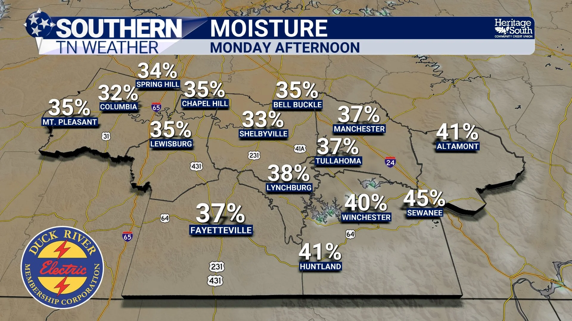
And that's particularly important when we're dealing with an atmosphere as dry as ours has been recently. Even if our upper-level ridge begins weakening, we still need enough moisture to support cloud development and precipitation. Without it, an approaching disturbance might produce little more than some passing clouds and a subtle shift in the wind. Breaking the ridge is only part of the equation. We also have to bring the moisture back!
Why Moisture Is the Missing Ingredient
This is probably the most important part of the entire discussion. We can have a perfectly positioned trough, falling atmospheric heights, and increasing cloud cover, but if the atmosphere doesn't contain enough moisture, meaningful rainfall may still be difficult to produce. Right now, our lower atmosphere has been exceptionally dry. And while that dry air has helped produce beautiful autumn weather, it also makes it difficult for precipitation to reach the ground.
When rainfall develops in a cloud and begins falling into a dry layer of air, some or all of those droplets can evaporate before reaching the surface. This process can produce something called virga, which is precipitation that falls from a cloud but evaporates before reaching the ground. To finally produce widespread, beneficial rainfall across Southern Middle Tennessee, we generally need a combination of increasing atmospheric moisture, sufficient upward motion, and a weather system capable of organizing that moisture into precipitation.
One potential source of moisture is the Gulf. When the larger-scale atmospheric circulation becomes favorable, southerly winds can transport moisture northward into Tennessee, increasing humidity and making the atmosphere more supportive of rainfall. However, the exact placement of an approaching trough or surface low-pressure system matters tremendously. A slight difference in the storm track can influence how much moisture reaches our region, where the strongest lift develops, and which communities receive the heaviest rainfall. That's why forecasting exact rainfall totals several days in advance can be so difficult, particularly when we're transitioning out of a long-lasting dry pattern.
We may become increasingly confident that a weather system will approach the region before we can confidently determine exactly when rainfall will begin or how much any particular community will receive. And that brings us to our upcoming weekend!
Could This Weekend FINALLY Bring Our First Meaningful Rainfall in Weeks?
After more than two weeks without meaningful rainfall across much of Southern Middle Tennessee, there are growing indications that our larger-scale weather pattern could begin changing as we head toward the upcoming weekend and the beginning of November. Our stubborn ridge of high pressure may begin weakening or shifting enough to allow a more organized weather system to approach the region. If that happens, increasing atmospheric moisture and more favorable lifting mechanisms could eventually provide our first meaningful opportunity for rainfall in quite some time. But before anybody starts sharing those colorful computer-model rainfall maps and celebrating the end of our drought, WE NEED TO PUMP THE BRAKES A LITTLE BIT!
We're still several days away from the potential event, and there's considerable uncertainty surrounding the exact evolution of the atmospheric pattern. Small changes in the position, strength, or timing of an approaching trough can have a significant influence on where precipitation develops and how much rainfall reaches Southern Middle Tennessee. Some model solutions may advertise widespread, beneficial rainfall, while others may keep the more substantial precipitation displaced away from our region. And even if the overall pattern becomes more favorable for rain, that doesn't guarantee every community will receive the same amount. It's also important to remember that one rainfall event, even a fairly substantial one, wouldn't necessarily eliminate our ongoing drought. We've accumulated significant moisture deficits over the past several weeks, and meaningful drought recovery will likely require multiple beneficial rainfall events rather than one isolated storm system.
For now, the best approach is to recognize that THE POTENTIAL FOR A PATTERN CHANGE IS THERE, while avoiding too much confidence in specific rainfall totals or timing this far in advance. We'll continue watching how the upper-level ridge evolves, whether approaching disturbances become better organized, and how quickly atmospheric moisture can return to Southern Middle Tennessee. Those details will ultimately determine whether our first meaningful rain chance in more than two weeks becomes a reality.
First, We've Still Got Several Beautiful Fall Days Ahead!
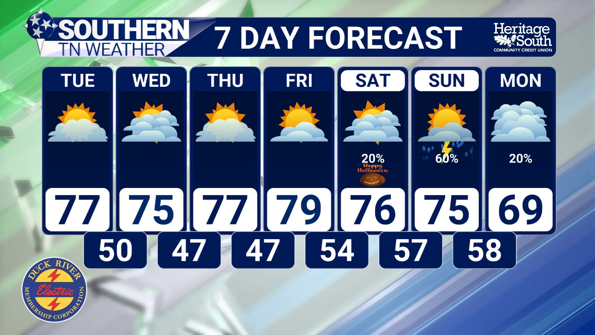
Before any potential changes arrive, we're looking at several more days of pleasant autumn weather across Southern Middle Tennessee. Today will feature a mixture of sunshine and clouds, with afternoon temperatures generally climbing into the middle 70s. Those high clouds will occasionally filter the sunshine, but no meaningful rainfall is expected. Tonight will be another cool autumn night, with temperatures generally falling into the 40s.
Tuesday and Wednesday should feature more pleasant conditions, with a mixture of sunshine and occasional clouds and afternoon highs generally remaining in the 70s. Overnight temperatures will continue falling into the 40s and lower 50s, depending on cloud cover and local conditions.
By Thursday and Friday, temperatures may warm even further, with afternoon highs potentially reaching the lower 80s in portions of our coverage area. That's certainly on the warm side for the final days of October, although not entirely unusual when a persistent ridge continues influencing our weather.
Unfortunately, our ongoing drought will remain a concern throughout the workweek. The combination of continued dry weather, relatively warm afternoon temperatures, and periods of low humidity will do little to improve soil moisture conditions. Fire safety will also remain important, especially in areas containing dry grasses, fallen leaves, and other vegetation. As we head toward Saturday and Sunday, we'll be watching for the possibility of a more substantial change in the atmospheric pattern. Rain chances may begin increasing as a weather system approaches, but the exact timing, coverage, and rainfall amounts remain uncertain. And if you've got Halloween plans Saturday evening, don't cancel anything just yet! We're still far enough away that the forecast could change considerably as we get closer to the weekend. The important takeaway is that our weather pattern may FINALLY be showing some signs of becoming more active, but we need several more days of forecast guidance before making confident predictions about rainfall.
The Bottom Line 🧾
☀️ Another beautiful fall day is underway! Expect a mixture of sunshine and clouds with temperatures generally in the 70s across Southern Middle Tennessee.
🌎 A persistent upper-level ridge has helped keep our weather exceptionally dry, favoring sinking air and limiting widespread cloud development and rainfall.
🌬️ The jet stream plays a major role in breaking stubborn weather patterns. Changes in the atmospheric circulation upstream can eventually influence the position and strength of ridges and troughs over our region.
🌊 Rossby waves help explain how atmospheric disturbances evolve and influence weather patterns thousands of miles downstream.
📉 An approaching trough can weaken or displace an existing ridge, but the exact interaction depends on the larger-scale atmospheric flow.
☁️ Increasing high clouds can indicate changes occurring in the upper atmosphere, although they don't necessarily guarantee rainfall.
💧 Moisture is a critical ingredient! Even if our ridge weakens, we still need sufficient atmospheric moisture and upward motion to produce meaningful precipitation.
🌡️ Beautiful weather continues through much of the workweek, with highs generally in the 70s and potentially reaching the lower 80s Thursday and Friday.
🌵 Our ongoing drought remains a serious concern, with no meaningful rainfall expected during the first part of the week.
🌧️ A potential pattern change could bring rain chances back this weekend, but confidence in the exact timing and rainfall amounts remains limited.
📰 Reminder: The Southern Tennessee Weather Blog, presented by Heritage South Community Credit Union, is updated Monday through Friday with fresh, locally tailored forecasts you can trust.
