
Extreme Drought Expands Across Southern Middle Tennessee

The Southern Tennessee Weather Blog is proudly presented by Heritage South Community Credit Union.
We Help When Others Won’t!
Visit https://www.heritagesouth.org/ today to see how HSCCU can help YOU!
EXTREME DROUGHT CONTINUES TO EXPAND ACROSS SOUTHERN MIDDLE TENNESSEE! The latest U.S. Drought Monitor was released this morning, and unfortunately, the news isn't good. After several weeks of unusually warm temperatures and very little meaningful rainfall, drought conditions have deteriorated significantly across much of our region. In fact, a large portion of Middle Tennessee is now experiencing D3 Extreme Drought, the second-highest classification on the U.S. Drought Monitor scale.
If you've been following our weather updates over the past several weeks, this probably doesn't come as much of a surprise. We've been dealing with a remarkably persistent weather pattern featuring abundant sunshine, afternoon temperatures well above seasonal averages, and very little precipitation. While the weather has certainly been enjoyable for outdoor activities, the lack of rainfall has taken a considerable toll on our soils, vegetation, and overall drought conditions.
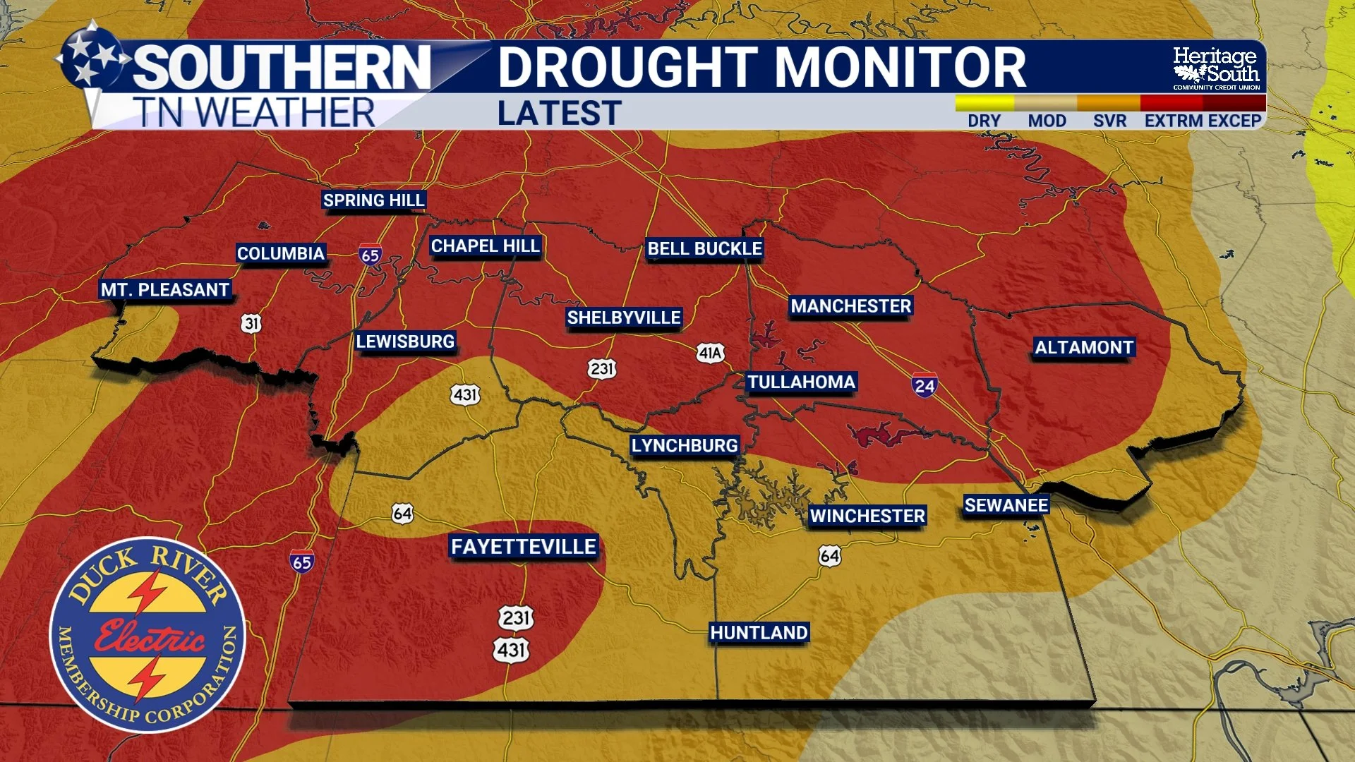
The latest Drought Monitor map, valid October 27 and released this morning, shows just how widespread these conditions have become. Extreme Drought has expanded across substantial portions of Middle Tennessee, including parts of our Southern Middle Tennessee coverage area. Meanwhile, other communities remain under Severe or Moderate Drought conditions, with some of the easternmost areas experiencing less significant drought impacts. And unfortunately, these conditions didn't develop overnight. They've been building for weeks, and in some locations, months.
Just How Bad Has Our Drought Become?
To put things into perspective, the U.S. Drought Monitor uses five categories to describe the severity of dry conditions, ranging from D0 Abnormally Dry to D4 Exceptional Drought. The higher the classification, the more significant the drought conditions and potential impacts. D3 Extreme Drought is a serious classification. It can be associated with substantial agricultural losses, significant reductions in soil moisture, increased wildfire concerns, and declining water availability. However, the specific impacts vary depending on local conditions, water supplies, and how long the drought persists.
Across Southern Middle Tennessee, the expansion of D3 conditions is particularly concerning because we're entering a time of year when fallen leaves, dormant grasses, and other vegetation can provide additional fuel for wildfires. And while we've been fortunate to experience relatively light winds on many of our recent dry afternoons, that doesn't eliminate the potential for fires to develop and spread. The latest Drought Monitor also shows just how quickly conditions have deteriorated statewide. As of this week's update, approximately 38.64% of Tennessee is experiencing Extreme Drought or worse, compared to 18.80% just one week ago. That's an increase of nearly 20 percentage points in only seven days!
Meanwhile, nearly 60% of Tennessee is experiencing Severe Drought or worse, and more than 91% of the state is classified as Abnormally Dry or worse. Those are some pretty remarkable numbers, and they demonstrate just how widespread our ongoing drought has become. However, I want to emphasize that the most severe category, D4 Exceptional Drought, remains confined to a small portion of West Tennessee. Our primary concern here in Southern Middle Tennessee is the expansion of D3 Extreme Drought and the persistence of Severe Drought in surrounding communities.
Why Have Conditions Deteriorated So Quickly?
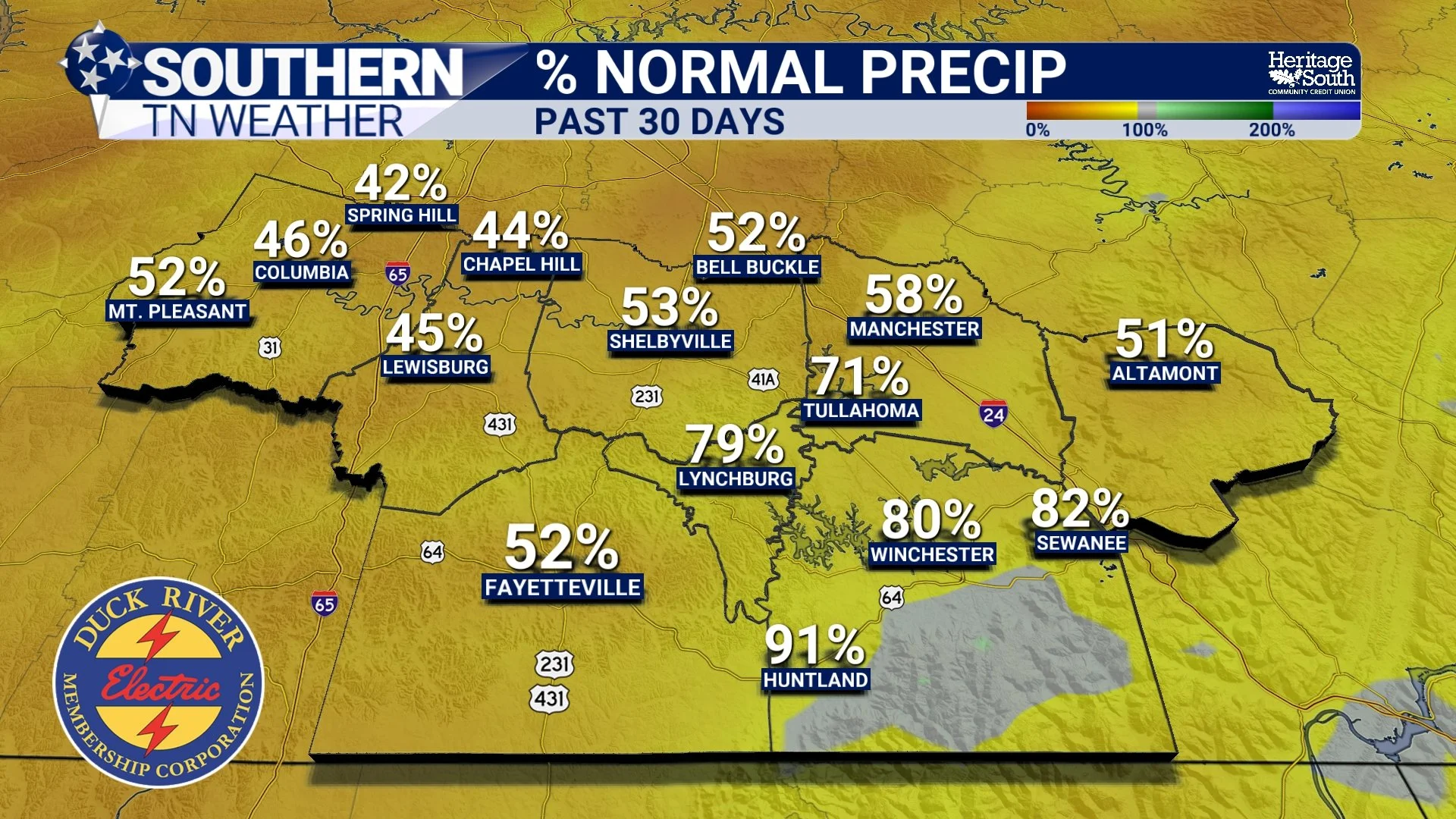
The answer comes down to a combination of insufficient rainfall, unusually warm temperatures, and a remarkably persistent atmospheric pattern. Over the past month, much of Tennessee has received considerably less rainfall than normal. The latest precipitation analysis indicates that many locations across the state have accumulated only one to two inches of rainfall over the past 30 days, although portions of Southern Middle Tennessee have received somewhat higher totals.
Across much of the state, those amounts represent only about 25% to 50% of normal precipitation. And when you combine below-normal rainfall with above-normal temperatures, drought conditions can worsen relatively quickly. Over the past 30 days, temperatures across Tennessee have generally averaged between two and eight degrees above normal. Those warmer conditions can increase evaporation and the atmospheric demand for moisture, particularly during periods featuring low humidity.
Of course, October naturally brings shorter days and a gradual reduction in evaporation compared to the summer months. However, prolonged warm and dry conditions can still contribute to declining soil moisture, especially when meaningful rainfall remains absent. We've also spent much of the past several weeks underneath a persistent ridge of high pressure. As we've discussed in previous weather blogs, these atmospheric ridges frequently promote sinking air and suppress widespread precipitation. The result has been a frustratingly consistent pattern of sunny skies, mild afternoons, cool nights, and very little rainfall. And while that pattern may finally be showing signs of changing, the drought impacts aren't going to disappear overnight.
What Does Extreme Drought Actually Mean for Our Communities?
When people hear the term Extreme Drought, they sometimes imagine completely dried-up lakes, widespread water shortages, or barren landscapes. However, drought impacts can develop gradually, and they don't necessarily look the same in every community. One of the earliest and most noticeable impacts involves soil moisture. As precipitation deficits accumulate, the upper layers of soil begin drying out. If the dry weather persists, moisture deficits can extend deeper into the ground, affecting vegetation, agricultural operations, and the ability of soils to support healthy plant growth.
For our agricultural communities across Bedford, Coffee, Franklin, Lincoln, Marshall, Maury, Moore, and Grundy counties, prolonged drought can create challenges involving pasture conditions, forage availability, and soil moisture. Another concern involves streams, creeks, and other water resources. Streamflow naturally fluctuates throughout the year, and lower flows are common during autumn. However, extended precipitation deficits can contribute to reduced streamflow and declining water availability in some locations.
Then there's the wildfire concern. As vegetation continues drying out, fallen leaves, grasses, and other fuels can become increasingly susceptible to ignition. Even when winds are relatively light, a fire can still spread through sufficiently dry vegetation. And with the latest outlook indicating above-normal significant wildfire potential across much of Tennessee during November, this is something we'll need to take seriously as we head into the coming weeks.
The bottom line is that drought isn't simply about how long it's been since your backyard received rainfall. It's about how prolonged moisture deficits affect the environment, agriculture, water resources, and the communities that depend on them.
Could This Weekend FINALLY Bring Some Much-Needed Rainfall?
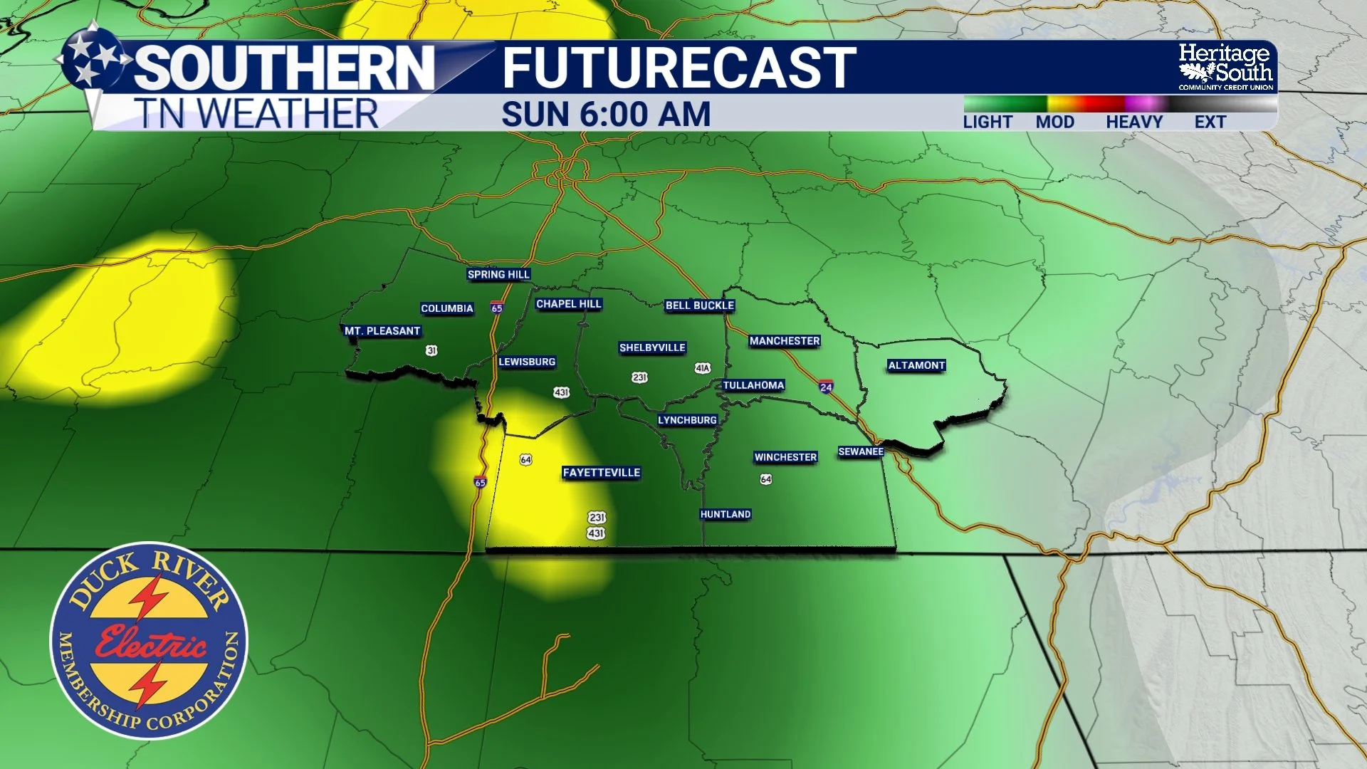
Now, let's talk about something a little more encouraging! After more than two weeks without meaningful rainfall across much of Southern Middle Tennessee, our stubborn weather pattern is FINALLY beginning to change. We're expecting another warm and generally dry day today, with afternoon highs climbing into the upper 70s and lower 80s for many communities. Similar conditions are expected Friday before our attention turns toward an approaching weather system this weekend. Rain chances are expected to begin increasing Saturday, particularly as we head into Saturday night. The better opportunity for more widespread rainfall currently appears to arrive late Saturday night into Sunday, although the exact timing remains somewhat uncertain.
And with Halloween festivities scheduled for Saturday evening, that timing will certainly be important! While a few scattered showers could develop during the afternoon or evening hours, there's still a reasonable possibility that much of the traditional trick-or-treating period will remain dry. However, rain chances are expected to increase as the evening progresses, especially overnight. As we head into Sunday, more widespread showers are possible, potentially providing our first meaningful rainfall in quite some time.
But here's where we need to be careful. ONE RAINFALL EVENT IS NOT GOING TO ELIMINATE OUR DROUGHT! Even if we receive a widespread soaking rainfall, the accumulated moisture deficits across our region are substantial. It will likely take multiple rainfall events over an extended period to produce meaningful and sustained improvements in drought conditions.
Nevertheless, rainfall this weekend would certainly be welcome. It could help replenish some of the moisture in the upper layers of soil, provide temporary relief for dry vegetation, and potentially slow or halt further deterioration in some areas. And believe it or not, this weekend's system may not be our only opportunity for rainfall!
Could November FINALLY Bring a Wetter Weather Pattern?
This is where the longer-range forecast becomes particularly interesting. In addition to the approaching weekend system, another weather disturbance could affect our region during the first half of next week. While the exact timing and rainfall amounts remain uncertain, the possibility of multiple precipitation events is an encouraging development after such an extended dry spell. The latest seven-day precipitation outlook indicates that portions of Tennessee could receive approximately one to two and a half inches of rainfall through the middle of next week, with some of the highest totals potentially occurring in areas currently experiencing the most significant drought conditions.
However, these are forecast amounts covering multiple potential weather systems, not guaranteed rainfall totals from a single event. The exact distribution of precipitation across Southern Middle Tennessee will depend on how those systems develop and track. Looking a little farther ahead, the Climate Prediction Center's 8–14 day outlook provides another encouraging signal. For the November 5–11 period, Tennessee has approximately a 33% to 40% probability of above-normal precipitation. That doesn't guarantee a wet week, but it does indicate that the odds are tilted somewhat toward wetter-than-normal conditions during that period. And when we look even farther ahead into November, December, and January, the seasonal outlook generally favors near-normal to above-normal precipitation across much of Tennessee.
That's certainly encouraging news considering how dry conditions have become. However, there's an important distinction between a wetter forecast and immediate drought recovery. Even if we transition into a more active weather pattern, the atmosphere will need to produce enough rainfall over time to overcome the moisture deficits that have accumulated during our extended dry period.
Some improvements could occur relatively quickly in surface soil moisture, while deeper soil moisture, groundwater, and other water resources may take considerably longer to recover. The latest drought outlook suggests that drought conditions will likely persist in the short term, with gradual improvements possible as we move deeper into late fall and early winter. And at this point, I think we'll gladly take ANY encouraging signs we can get!
The Bottom Line 🧾
Extreme Drought (D3) has expanded across substantial portions of Southern Middle Tennessee, with Severe Drought continuing in surrounding communities.
Approximately 38.64% of Tennessee is now experiencing Extreme Drought or worse, compared to 18.80% last week.
Nearly 60% of Tennessee is experiencing Severe Drought or worse, while more than 91% is classified as Abnormally Dry or worse.
The most severe category, D4 Exceptional Drought, remains confined to a small portion of West Tennessee.
Below-normal rainfall, above-normal temperatures, and persistent high pressure have contributed to rapidly worsening drought conditions.
Wildfire concerns remain elevated as vegetation continues drying out, with above-normal significant wildfire potential forecast across much of Tennessee during November.
Rain chances return this weekend, with the better opportunity for widespread rainfall currently expected late Saturday night into Sunday.
The seven-day precipitation outlook indicates that portions of Tennessee could receive approximately 1 to 2.5 inches of rainfall through the middle of next week.
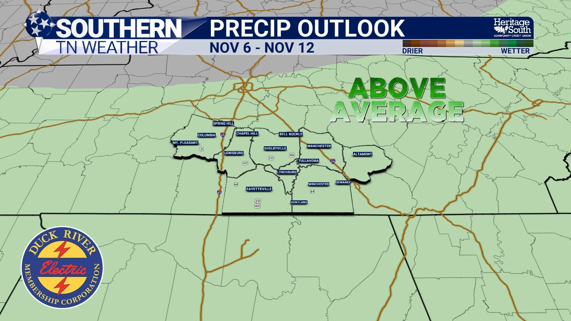
The November 6–12 outlook favors increased chances for above-normal precipitation, providing some hope for a wetter weather pattern.
Drought conditions are expected to persist in the short term, but gradual improvement may become possible if beneficial rainfall continues into November and early winter.
📰 Reminder: The Southern Tennessee Weather Blog, presented by Heritage South Community Credit Union, is updated Monday through Friday with fresh, locally tailored forecasts you can trust
