

The Southern Tennessee Weather Blog is proudly presented by Heritage South Community Credit Union.
We Help When Others Won’t!
Visit https://www.heritagesouth.org/ today to see how HSCCU can help YOU!
If you've stepped outside today, you've probably already noticed that our MUCH colder air mass has arrived across Southern Middle Tennessee! After enjoying temperatures in the 70s earlier this week, we're now dealing with a completely different weather pattern, and some of the coldest temperatures of the fall season are still ahead of us. In fact, we're looking at our first widespread HARD FREEZE of the season this weekend, with overnight lows dropping well into the 20s across much of our region!
The good news is that the weekend itself is shaping up to be rather nice if you don't mind the cold. Sunshine will gradually return, temperatures will slowly begin recovering, and by the middle of next week, we could be back into the 60s. However, there's one downside to the extended forecast, especially considering our ongoing drought conditions. We're looking at another stretch of dry weather, with little to no meaningful rainfall expected over the next several days.
So, let's break down what to expect this weekend, why our coldest temperatures may actually arrive Sunday morning, and when we'll finally start warming back up!
Friday: A Chilly Start to the Weekend!
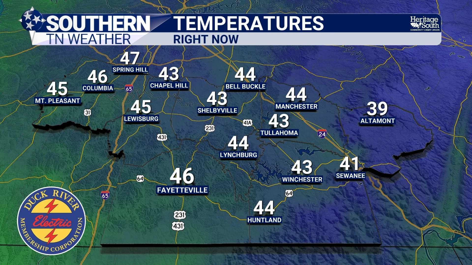
We're dealing with a rather chilly Friday across Southern Middle Tennessee, with afternoon temperatures struggling to climb much beyond the 40s. Most communities will see highs in the lower to middle 40s, while locations along the Cumberland Plateau may struggle to get out of the upper 30s. For perspective, our average high temperature for November 13 is around 62 degrees, meaning we're running nearly 20 degrees BELOW average!
We'll see a mixture of clouds and sunshine throughout the afternoon, although exactly how warm we get will depend heavily on how much sunshine manages to break through. A little more sunshine could push temperatures a few degrees higher than forecast, but either way, it's going to feel CHILLY with a brisk northwest wind. Winds will generally run around 10–15 MPH, with occasional higher gusts possible, especially across our more exposed locations. That means even if the thermometer reads 43 degrees, it could FEEL more like the middle 30s at times!
There's also a small chance for a few isolated light rain showers this afternoon and evening, especially east of Interstate 65, as another upper-level disturbance rotates through our region. However, these showers should be few and far between, with little to no measurable rainfall expected. Many communities will remain completely dry, and any lingering precipitation should come to an end later tonight as our weather pattern begins settling down.
Saturday and Sunday: Our First Widespread Hard Freeze!
Once we get past Friday's lingering clouds and isolated precipitation, our attention turns toward the BIG weather story of the weekend: freezing temperatures! A strong area of high pressure will begin building into the region, allowing skies to gradually clear and winds to become lighter. While that will make for some rather pleasant afternoon conditions, it also creates an ideal setup for temperatures to drop quickly after sunset.
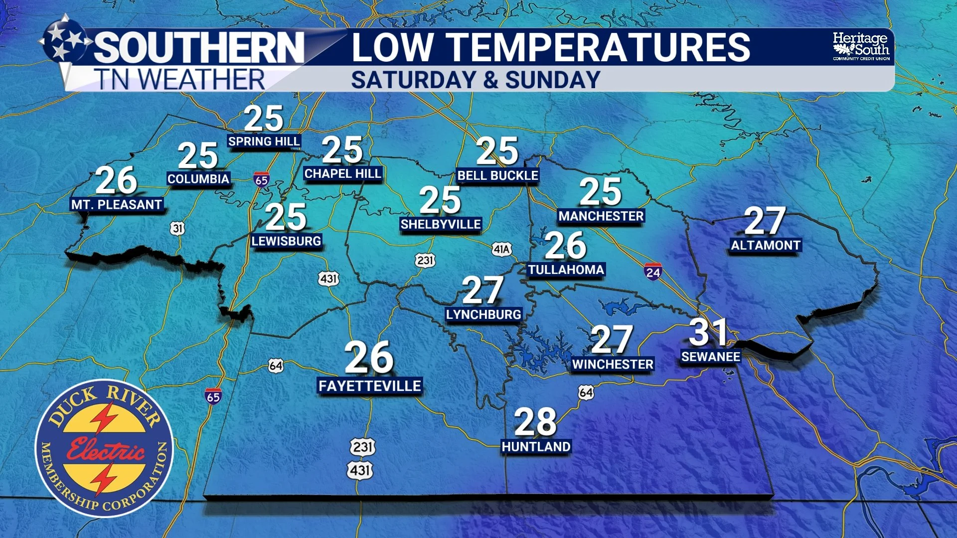
By Saturday morning, temperatures are expected to fall into the middle to upper 20s across much of Southern Middle Tennessee, with some sheltered valleys potentially becoming even colder. Locations that hang on to cloud cover a little longer Friday night, especially near the Cumberland Plateau, may not cool quite as efficiently as communities farther west. Nevertheless, widespread freezing temperatures are expected, and many locations will experience their first hard freeze of the season.
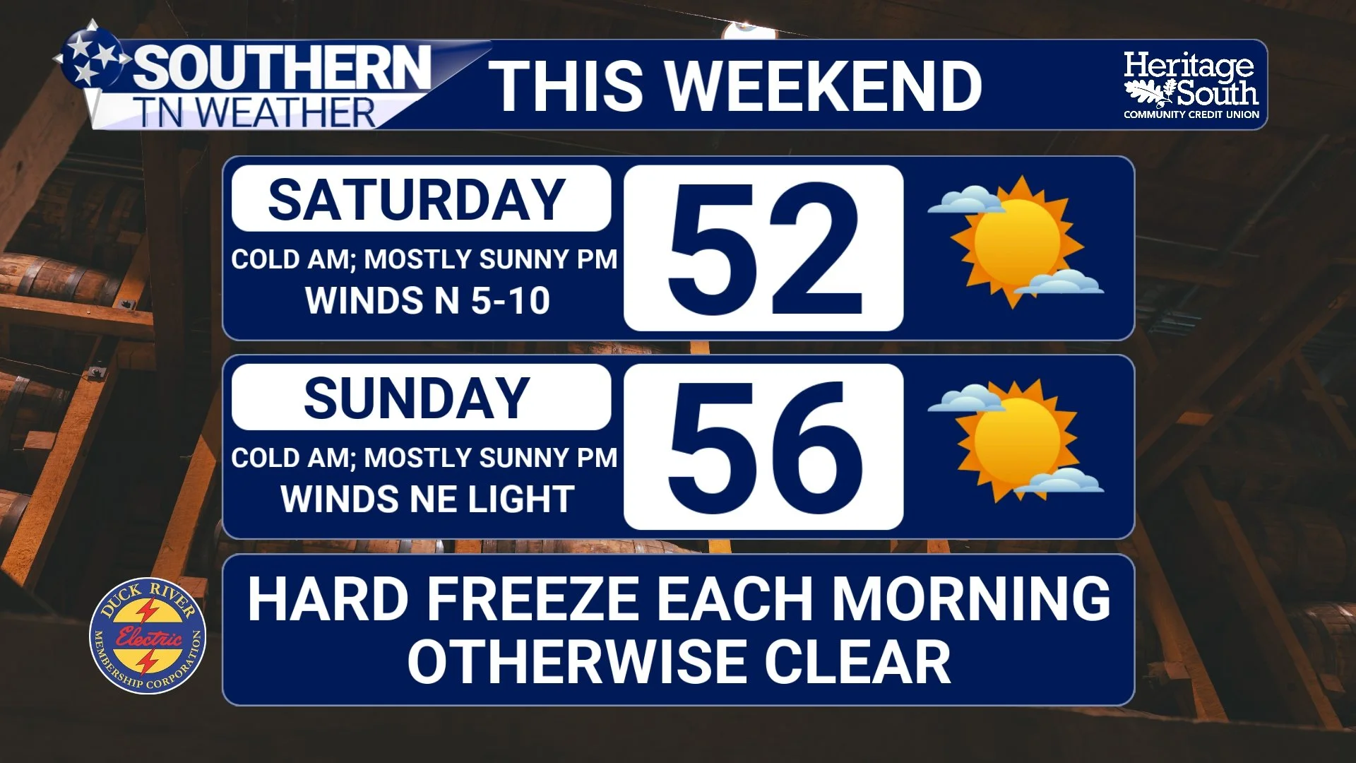
Saturday afternoon will actually be rather nice compared to Friday, with mostly sunny skies and highs recovering into the lower 50s. Winds will be much lighter, generally out of the north around 5–10 MPH, so we won't have quite the same biting wind chill that we're dealing with today. If you've got outdoor plans Saturday afternoon, the weather should cooperate nicely, although you'll certainly want a jacket during the morning and evening hours.
But here's where things get interesting. Despite temperatures warming a few degrees Saturday afternoon, Sunday morning could actually be COLDER than Saturday morning! As high pressure settles over the region, skies should become mostly clear and winds will turn nearly calm. Those conditions allow the ground to lose heat efficiently overnight through radiational cooling, while colder air settles into our valleys and other low-lying areas.
As a result, widespread lows in the middle 20s look likely Sunday morning, with a few of our colder sheltered communities potentially dipping into the lower 20s. This will likely be our coldest morning of the weekend, and it could be the event that officially brings the growing season to an end across much of Southern Middle Tennessee. Remember, temperatures don't have to reach the teens or single digits to cause significant damage to vegetation. Several hours with temperatures at or below 28 degrees can be enough to produce a hard freeze, especially for sensitive plants that haven't fully adapted to colder weather.
If you still have any tender outdoor plants, now is the time to protect them or bring them indoors if possible. It's also a good idea to disconnect garden hoses, take precautions with exposed plumbing, and make sure outdoor pets have adequate protection from the cold. And as a reminder, the National Weather Service Nashville office no longer routinely issues Frost Advisories or Freeze Watches and Warnings after October 1, but that certainly doesn't mean damaging freezing temperatures can't occur!
Once we get through Sunday's cold start, afternoon temperatures should recover into the middle to upper 50s under mostly sunny skies. That's still a little cooler than average for the middle of November, but compared to Friday, it's going to feel considerably more comfortable!
Next Week: Temperatures Recover, but Where's the Rain?
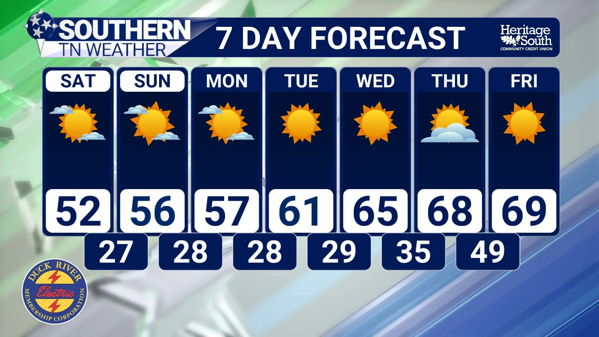
Looking beyond the weekend, our weather pattern will begin transitioning away from the deep upper-level trough responsible for our current cold outbreak. An upper-level ridge will gradually build eastward across the region, allowing temperatures to slowly moderate as we head through the first half of next week. Monday should feature highs in the middle to upper 50s, with temperatures gradually climbing into the lower and middle 60s by Tuesday and Wednesday.
However, don't expect our overnight temperatures to warm up quite as quickly! With high pressure remaining in control, relatively dry air, clear skies, and light winds will continue to favor chilly mornings. Overnight lows could remain in the upper 20s and lower 30s early next week, particularly in our sheltered valleys, before gradually moderating as the week progresses.
Unfortunately, there's one aspect of this forecast that I'm not particularly excited about, and that's the lack of rainfall. As we discussed in Thursday's drought update, the latest U.S. Drought Monitor finally showed some improvement across portions of western and central Tennessee following the beneficial rainfall we received earlier this month. That was certainly welcome news, especially after watching drought conditions worsen throughout much of September and October. However, those improvements don't mean our drought has ended, and additional rainfall will be necessary to continue replenishing soil moisture, streams, and groundwater supplies.
With high pressure dominating our weather pattern through much of next week, widespread rainfall simply doesn't look likely. While the sunshine and milder temperatures will certainly be enjoyable, it's not exactly the pattern we need for continued drought recovery. We'll have to keep watching the longer-range forecast for signs of another organized storm system, but for now, our next meaningful opportunity for rain remains uncertain.
The Bottom Line 🧾
Friday: A chilly afternoon with highs generally in the lower to middle 40s, brisk northwest winds, and a mixture of clouds and sunshine. A few isolated light rain showers are possible, especially east of Interstate 65.
Friday night: Widespread freezing temperatures, with lows generally in the middle to upper 20s.
Saturday: Mostly sunny and chilly, with highs in the lower 50s and lighter winds.
Saturday night into Sunday morning: Likely our COLDEST period of the weekend, with widespread lows in the middle 20s and some colder valleys potentially dipping into the lower 20s.
Sunday: Mostly sunny with highs recovering into the middle to upper 50s.
Hard freeze: Our first widespread hard freeze of the season is expected this weekend. Protect sensitive vegetation, outdoor pets, and exposed plumbing.
Early next week: A gradual warming trend brings afternoon highs back into the 60s by Tuesday and Wednesday, although mornings remain chilly.
Rain chances: Little to no meaningful rainfall expected through the middle of next week, which isn't ideal for our ongoing drought conditions.
📰 Reminder: The Southern Tennessee Weather Blog, presented by Heritage South Community Credit Union, is updated Monday through Friday with fresh, locally tailored forecasts you can trust
