

The Southern Tennessee Weather Blog is proudly presented by Heritage South Community Credit Union.
We Help When Others Won’t!
Visit https://www.heritagesouth.org/ today to see how HSCCU can help YOU!
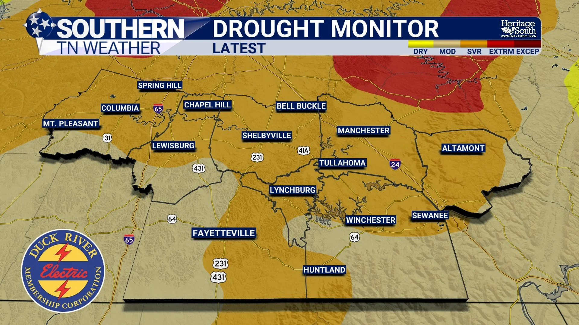
FINALLY! After weeks of watching drought conditions worsen across Southern Middle Tennessee, we’ve got some GOOD NEWS to share! The latest U.S. Drought Monitor, released Thursday morning, shows some much-needed improvement across western and central Tennessee following the beneficial rainfall we received during the first week of November. While we’re certainly not out of the woods just yet, this is an encouraging development after a rather frustrating stretch of dry weather throughout much of the fall.
According to this week’s Drought Monitor assessment, significant drought relief occurred across portions of western and central Tennessee, where several inches of rainfall helped reduce the coverage and intensity of Extreme Drought (D3). That’s especially welcome news considering how quickly conditions deteriorated during September and October. However, the improvement hasn’t been uniform, and substantial drought conditions remain across portions of Southern Middle Tennessee.
The rainfall responsible for much of this improvement arrived in two separate rounds. Our first widespread rainfall event occurred Sunday, November 1, bringing beneficial moisture to much of the region. Then, on Wednesday, November 4, another organized storm system produced widespread totals of 1–2 inches, with localized amounts exceeding 3 inches. Some of the heaviest rainfall occurred across eastern Maury, Marshall, and western Bedford counties, helping provide much-needed moisture to areas that had been experiencing significant rainfall deficits.
What’s particularly important about this week’s update is that it FINALLY includes the November 4 rainfall event. Last Thursday’s Drought Monitor was based on conditions through November 3, meaning that substantial rainfall hadn’t yet been factored into the assessment. This week’s map reflects conditions through Tuesday, November 10, giving us a better picture of how those recent rainfall events have affected our ongoing drought.
However, there’s a rather interesting contrast developing across the southern United States. While portions of Tennessee have experienced some improvement, exceptional drought has continued worsening across parts of Arkansas, Louisiana, Mississippi, southeastern Oklahoma, and eastern Texas. According to the National Centers for Environmental Information, some of those hardest-hit areas would need approximately 20–30 inches of rainfall over a three-month period to eliminate their Exceptional Drought (D4) conditions. Meanwhile, portions of southern and western Texas experienced substantial improvement following rainfall totals reaching as high as 9 inches in some locations. It’s a good reminder that drought conditions can vary dramatically from one region to another, even across neighboring states. And here locally, although we’re finally moving in the right direction, we still have plenty of ground to make up.
Why One Good Rain Doesn’t End a Drought
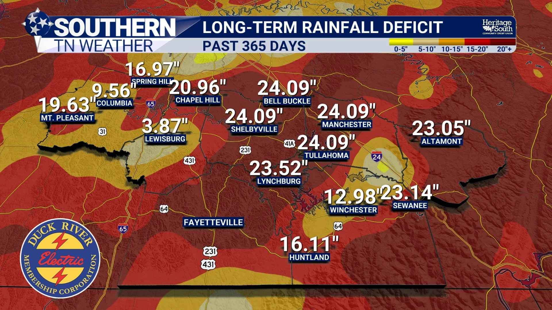
One of the biggest misconceptions about drought is that a single heavy rainfall event can completely eliminate it. Unfortunately, that’s rarely how things work, especially when drought conditions have been developing for several months. Our region accumulated substantial rainfall deficits throughout the fall, and while last week’s precipitation certainly helped, restoring deeper soil moisture, streamflow, and groundwater supplies generally requires a more sustained period of beneficial rainfall.
When rain falls after an extended dry spell, some of that moisture is absorbed into the upper layers of soil, while some runs off into nearby creeks and streams. Depending on rainfall intensity, soil conditions, and local terrain, a portion may also begin working deeper into the ground. However, replenishing deeper moisture supplies takes time, which is why a few inches of rainfall don’t necessarily translate into the complete elimination of drought conditions.
Another important factor is the difference between short-term and long-term drought. Short-term drought conditions are generally associated with more recent rainfall deficits and impacts on vegetation, agriculture, and topsoil moisture. Longer-term drought can affect groundwater, reservoirs, and streamflow over a much greater period. A few substantial rainfall events can sometimes produce noticeable improvements in short-term conditions, but eliminating longer-term deficits often requires several weeks or months of more consistent precipitation.
The good news is that we’re entering a time of year when cooler temperatures and reduced evaporation can help make rainfall more effective at replenishing soil moisture. Vegetation also generally requires less water during the colder months, meaning more of the moisture that falls can remain available for infiltration and runoff. Unfortunately, there’s one rather important ingredient we still need if we’re going to continue making progress, and that’s MORE RAIN!
A BIG Cooldown Arrives, but Rainfall Remains Limited
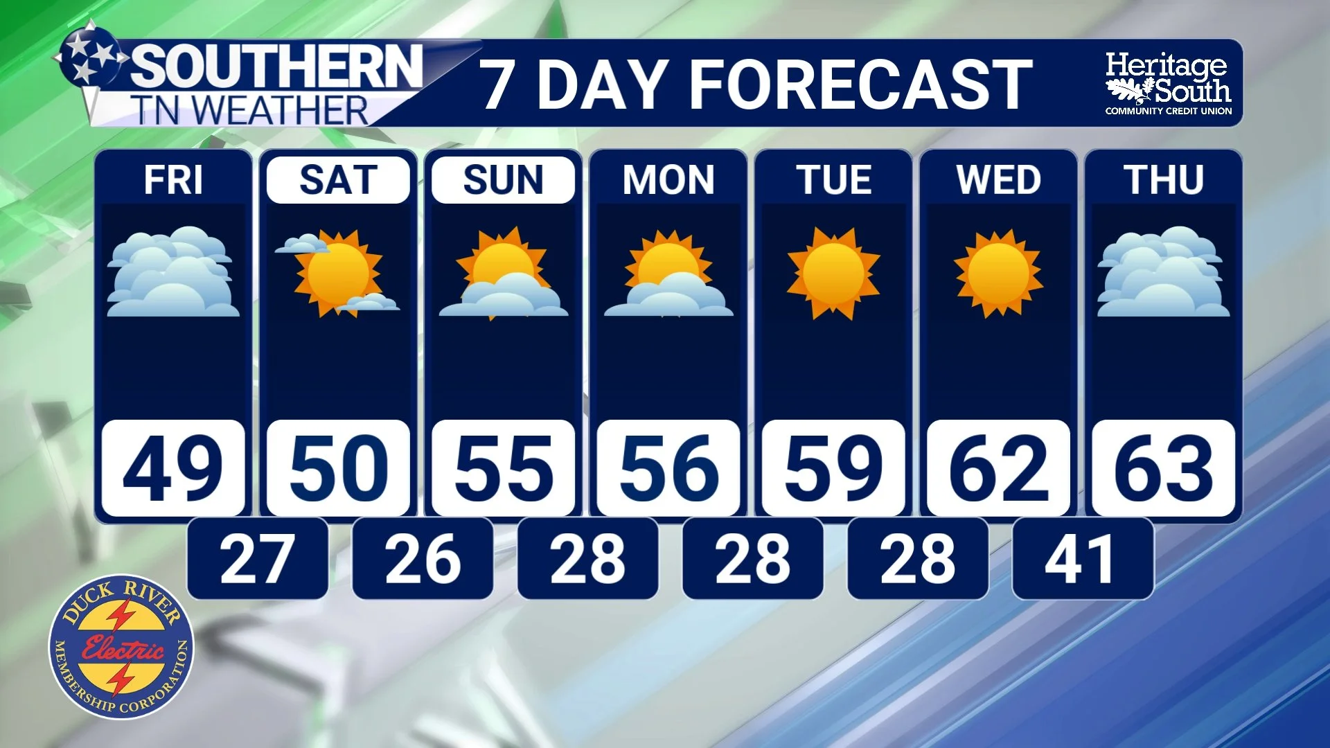
Now, let’s shift gears and talk about our forecast because we’ve got some significant weather changes underway across Southern Middle Tennessee! The strong cold front that moved through Wednesday evening has ushered in a much colder air mass, and temperatures are going to take a pretty substantial tumble over the next several days. After enjoying highs in the 70s earlier this week, we’ll struggle to reach the upper 50s today, with even colder conditions expected Friday and into the weekend.
Thursday will feature a mixture of sun and clouds, with afternoon highs generally in the middle to upper 50s. As an upper-level disturbance rotates through the region, a few scattered light showers and areas of drizzle could develop during the afternoon and evening. However, widespread rainfall is NOT expected, and many communities may not receive anything measurable. Any lingering light precipitation should gradually come to an end overnight, with temperatures falling into the upper 20s and lower 30s by Friday morning.
Friday will be another rather chilly day, with afternoon highs struggling to climb beyond the middle to upper 40s across much of Southern Middle Tennessee. We’ll see a mixture of sun and clouds, and I’m still keeping an eye on the possibility of a few passing snow flurries, especially across the higher elevations of the Cumberland Plateau. Communities around Monteagle, Sewanee, and Altamont would have the best opportunity to see a few flakes, although the overall chance remains relatively low. I’m NOT expecting any meaningful snowfall accumulations or travel impacts, and chances decrease substantially as you move westward off the Plateau.
But the BIG story arrives Friday night into Saturday morning as our first widespread HARD FREEZE of the season becomes increasingly likely! Temperatures are expected to fall into the middle 20s across much of Southern Middle Tennessee, with some of our colder, sheltered valleys potentially dropping even lower. Another round of widespread freezing temperatures is expected Saturday night into Sunday morning, meaning we could experience two consecutive mornings with temperatures well below freezing.
This will likely be the event that effectively brings the growing season to an end across much of our region. If you still have sensitive outdoor vegetation, now is the time to make preparations. Remember, the National Weather Service no longer routinely issues Frost Advisories or Freeze Watches and Warnings across our region after October 1, but that certainly doesn’t mean damaging freezing temperatures can’t occur!
As we head into the weekend, high pressure will gradually build into the region, bringing generally dry conditions and a mixture of sunshine and clouds. Afternoon temperatures should slowly recover into the 50s, with a more noticeable warming trend developing early next week. By the middle of next week, highs could return to the 60s, although overnight temperatures will remain rather chilly.
Unfortunately, the extended forecast doesn’t offer much encouragement for additional drought relief. While we’ll certainly enjoy the return of sunshine and somewhat milder temperatures, there aren’t any convincing signs of a substantial rainfall event developing over the next several days. That means our recent drought improvements could be followed by another stretch of dry weather, potentially slowing our progress toward more widespread recovery.
The Bottom Line 🧾
Drought improvement: The November 12 U.S. Drought Monitor reports significant drought relief across portions of western and central Tennessee following last week’s rainfall.
Extreme Drought: Some areas experienced reductions in D3 conditions, but significant drought remains across portions of our region.
Recent rainfall: Widespread totals of 1–2 inches, with localized amounts exceeding 3 inches on November 4, helped provide much-needed moisture.
Thursday: Cooler, with highs in the middle to upper 50s. A few light showers or areas of drizzle are possible.
Friday: Highs generally in the 40s, with a small chance of snow flurries, mainly along the Cumberland Plateau. No accumulation expected.
Friday night and Saturday morning: Our first widespread HARD FREEZE of the season is likely, with temperatures falling into the middle 20s.
Saturday night and Sunday morning: Another round of widespread freezing temperatures is expected.
Early next week: Temperatures gradually moderate, but generally dry conditions continue.
Looking ahead: Additional rainfall will be necessary to continue improving our drought situation.
📰 Reminder: The Southern Tennessee Weather Blog, presented by Heritage South Community Credit Union, is updated Monday through Friday with fresh, locally tailored forecasts you can trust
