

The Southern Tennessee Weather Blog is proudly presented by Heritage South Community Credit Union.
We Help When Others Won’t!
Visit https://www.heritagesouth.org/ today to see how HSCCU can help YOU!
What a difference a week makes! At this time last Friday, we were discussing our first widespread hard freeze of the fall season, with temperatures eventually dropping into the 20s across much of Southern Middle Tennessee. Fast forward to today, and we're enjoying afternoon temperatures in the lower 70s under mostly sunny skies! Considering our average high temperature for this time of year is around 60 degrees, we're running a good 10 to 15 degrees above normal.
The good news is that this beautiful weather will stick around for most of the upcoming weekend. However, we've reached the latter stages of our prolonged stretch of quiet weather, with a cold front expected to move through late Sunday into Monday morning. Beyond that, another disturbance could bring additional rainfall opportunities heading into Thanksgiving, along with a reinforcing shot of colder air.
There's quite a bit to unpack as we head into one of the busiest travel weeks of the year, so let's take a closer look!
A Beautiful Start to the Weekend
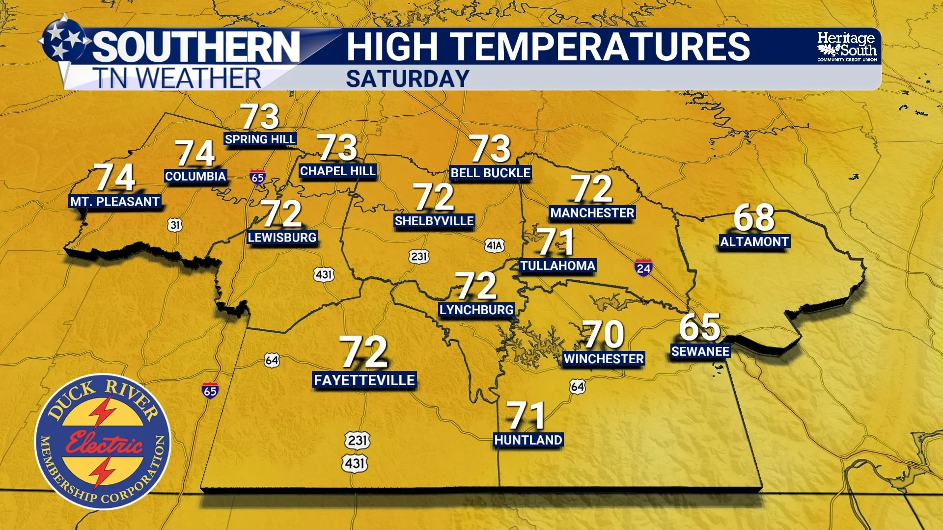
High pressure centered to our northeast will continue influencing our weather through Saturday, keeping any meaningful precipitation well away from Southern Middle Tennessee. We've seen a few high clouds filtering into the region today, but they certainly haven't prevented temperatures from warming nicely. Most communities will finish the afternoon in the lower 70s, with upper 60s across the higher elevations of the Cumberland Plateau.
If you're heading out to a high school football game this evening or have other outdoor plans, the weather couldn't be much more cooperative for late November. Temperatures will fall through the 50s following sunset before eventually settling into the upper 30s and lower 40s overnight. Winds will remain relatively light, so we won't have much of a wind chill to contend with.
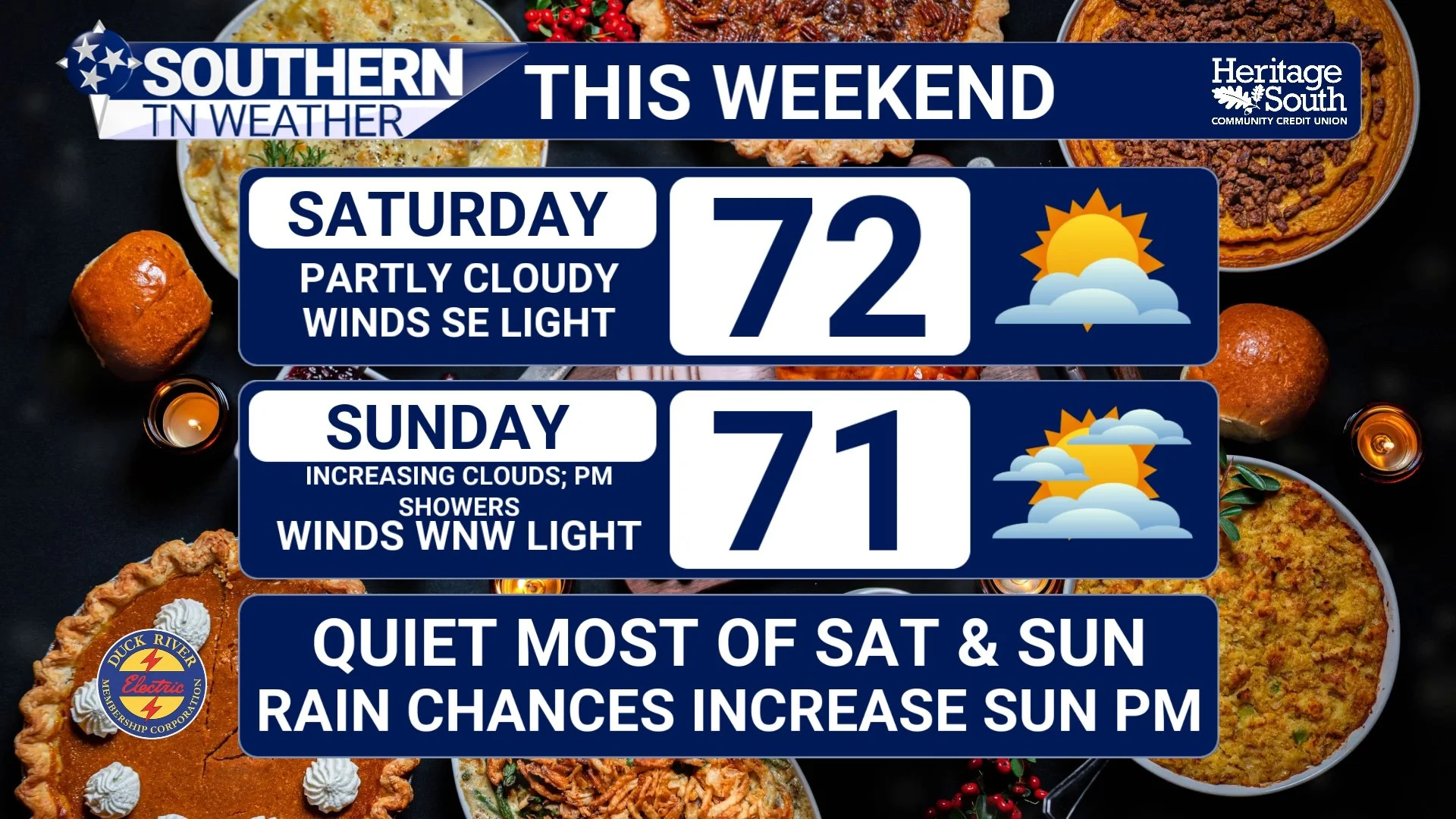
Saturday is shaping up to be another near-perfect day in the weather department. As high pressure gradually retreats farther northeast, a light southerly flow will become established across the region, allowing temperatures to remain well above average. Afternoon highs will once again climb into the lower 70s for most communities, with a few locations potentially reaching the middle 70s.
We may see some additional mid and high-level cloud cover filtering into the region, particularly across our eastern counties, thanks in part to a developing area of low pressure near the southeastern Atlantic coastline. However, that system will remain far enough away from us to prevent any meaningful local impacts. Saturday will remain dry across Southern Middle Tennessee, and it looks like an excellent opportunity to put up Christmas decorations, tackle some yard work, or simply spend some time outdoors.
Saturday night will be noticeably milder than many of the nights we've experienced recently, with lows generally in the 40s.
A Cold Front Brings Rain Chances Late Sunday
Things will gradually begin changing on Sunday as an upper-level trough and its associated cold front approach from the north and west. If you've been following my forecasts throughout the week, you've probably noticed that the timing of this system has gradually been pushed back. Earlier forecast guidance suggested we could see a few showers as early as Saturday, but the latest data continues to favor a late Sunday evening into Monday morning timeframe.
In fact, most of Sunday is looking rather pleasant! Afternoon temperatures should climb into the upper 60s and near 70 degrees across much of Southern Middle Tennessee, with cloud cover gradually increasing as the cold front approaches. I certainly wouldn't cancel any outdoor plans during the daytime hours on Sunday, as the vast majority of the region should remain dry until after sunset.
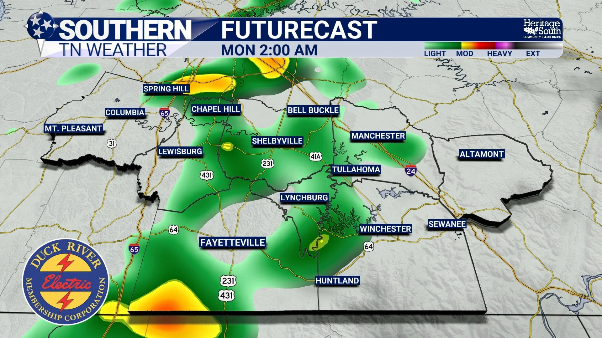
As the front moves closer Sunday evening, we'll begin introducing rain chances from west to east. Rain chances will generally range between 20% and 60% across Southern Middle Tennessee, with the higher probabilities across our western counties and somewhat lower probabilities farther east. A few scattered showers could continue into Monday morning before the cold front clears the region.
Unfortunately, I'm still not particularly impressed with this system from a drought relief standpoint. Despite atmospheric moisture gradually increasing ahead of the cold front, the overall setup doesn't appear favorable for widespread, substantial rainfall. Most communities that receive rain will likely see around a tenth of an inch or less, with localized totals approaching a quarter of an inch possible, particularly farther west. Some communities could miss out on measurable rainfall altogether.
Atmospheric instability will also be quite limited, so while an isolated rumble of thunder cannot be completely ruled out, the probability of thunderstorms remains very low. Severe weather is not currently a concern with this system.
As we discussed in yesterday's drought update, approximately half of Tennessee is experiencing severe drought conditions or worse. While any rainfall is certainly welcome at this point, we're going to need considerably more than what Sunday's system appears capable of producing to make another meaningful dent in our ongoing drought conditions.
A Much Cooler Thanksgiving Week Ahead
Once the cold front clears Southern Middle Tennessee by midday Monday, we'll begin feeling a rather noticeable change in our weather. Colder air will filter into the region from the north and west, bringing afternoon temperatures much closer to what we would normally expect for late November.
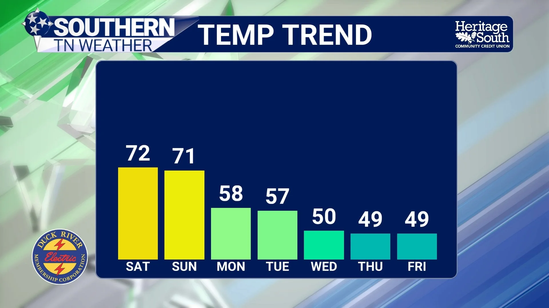
Highs on Monday and Tuesday will generally be in the middle and upper 50s, with some locations across our southern counties potentially reaching the lower 60s. Overnight temperatures will also return to the 30s in many communities. Both days are looking predominantly dry following the departure of Monday morning's showers, although we'll likely have a bit of a breeze to contend with behind the cold front.
Our attention will then turn toward another upper-level disturbance forecast to dig southward toward the Gulf Coast during the middle of next week. This will be our next opportunity for rainfall, and I'm a little more encouraged by the overall potential with this system compared to Sunday's cold front. Both the American and European ensemble guidance continue to support the possibility of showers on Wednesday, with rain chances currently running between 30% and 60%.
However, there are still some considerable differences among our forecast models regarding the strength, timing, and eventual track of this upper-level disturbance. Those details will ultimately determine how widespread rainfall becomes across Southern Middle Tennessee, how much rain we receive, and how quickly the system moves out of the region.
Considering Wednesday is one of the busiest travel days of the entire year, this will certainly be a system worth monitoring over the next several days. I'm not anticipating widespread significant weather-related travel disruptions at this point, but you'll want to keep an eye on forecast updates, especially if you're traveling outside of Southern Middle Tennessee for Thanksgiving.
An Early Look at Thanksgiving Day
Believe it or not, Thanksgiving Day is now less than a week away! While there are still some uncertainties surrounding our midweek storm system, the general temperature trend is becoming increasingly clear.
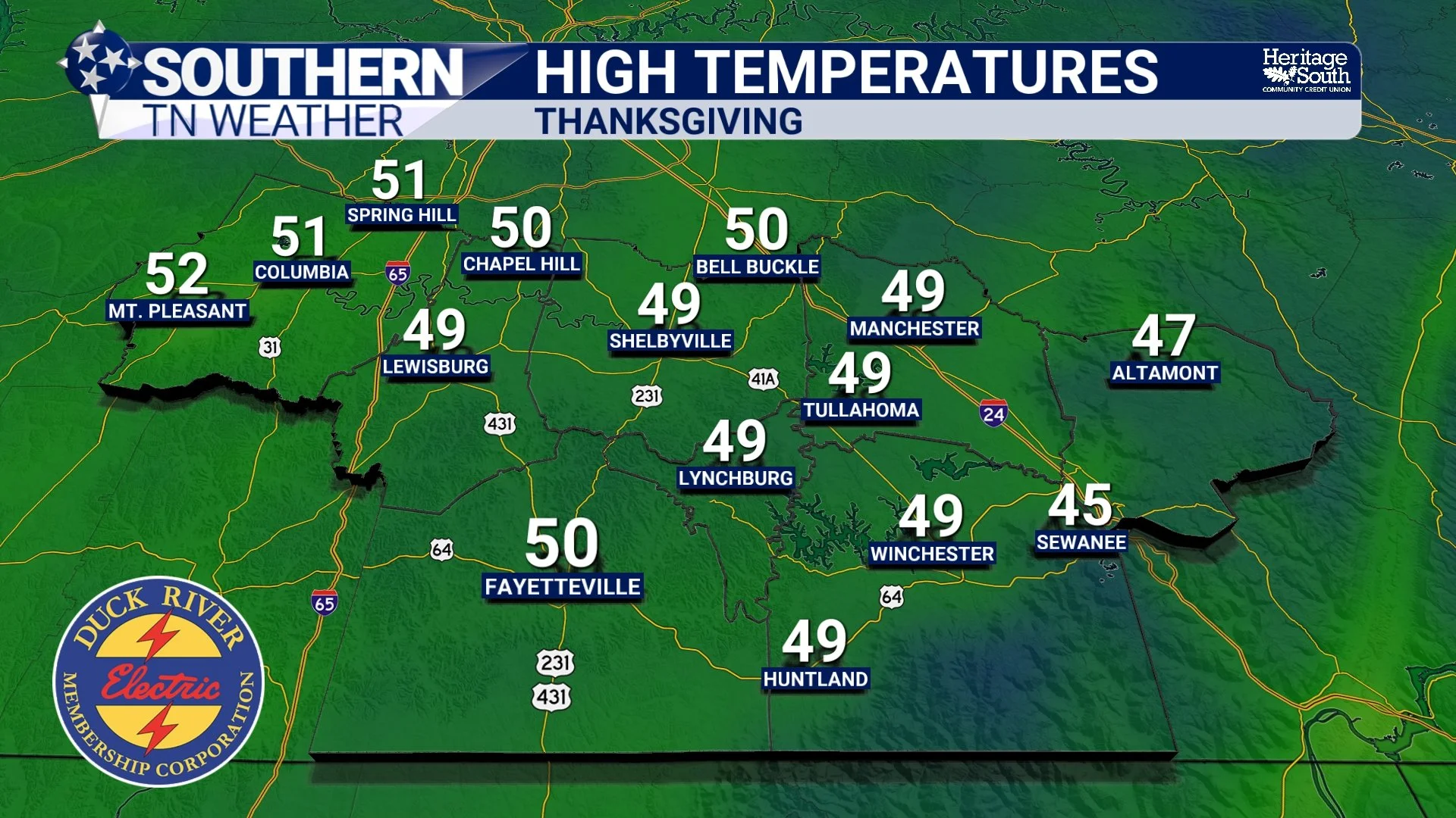
Following Wednesday's disturbance, another infusion of colder air is expected to move into the southeastern United States. This should make Thanksgiving Day considerably colder than what we're experiencing today and tomorrow, with afternoon highs generally in the upper 40s and near 50 degrees across Southern Middle Tennessee. Some of our higher-elevation communities could struggle to climb out of the middle 40s.
Morning temperatures on Thanksgiving Day could be near or below freezing in many locations, meaning we may be dealing with another round of frost as well. Quite the difference from the lower 70s we're enjoying this afternoon!
As far as precipitation is concerned, Thanksgiving Day itself is currently trending predominantly dry. However, that forecast is somewhat dependent on how quickly Wednesday's disturbance moves out of the region. A slower-moving system could result in lingering cloud cover or precipitation, while a faster-moving system would allow for more favorable conditions on Thanksgiving Day.
Beyond Thanksgiving, I'll continue monitoring the potential for additional disturbances moving through the region as we head toward the final days of November and the beginning of December. As we've discussed throughout the week, the broader upper-level weather pattern looks more active than what we've experienced recently. That's certainly encouraging news from a drought relief standpoint, but it's still too early to confidently discuss individual storm systems beyond Thanksgiving.
The Bottom Line 🧾
Beautiful weather continues through Saturday, with highs in the lower 70s and no rain expected.
Most of Sunday will remain dry, with highs in the upper 60s and near 70 degrees.
Scattered rain showers return late Sunday evening into Monday morning.
Rainfall totals will generally be around a tenth of an inch or less, with localized totals approaching a quarter of an inch.
Cooler and predominantly dry conditions return Monday and Tuesday following the cold front.
Another opportunity for rainfall arrives Wednesday, although timing and rainfall totals remain uncertain.
Thanksgiving Day is currently trending dry and chilly, with highs in the upper 40s and near 50 degrees.
📰 Reminder: The Southern Tennessee Weather Blog, presented by Heritage South Community Credit Union, is updated Monday through Friday with fresh, locally tailored forecasts you can trust
