

The Southern Tennessee Weather Blog is proudly presented by Heritage South Community Credit Union.
We Help When Others Won’t!
Visit https://www.heritagesouth.org/ today to see how HSCCU can help YOU!
It's Thursday, which means we have another update from the U.S. Drought Monitor! After finally seeing some meaningful improvements to drought conditions across Southern Middle Tennessee over the past couple of weeks, we're once again finding ourselves in an extended stretch of dry weather. While the sunshine and unseasonably warm temperatures have certainly been enjoyable, we're still in desperate need of additional rainfall before heading into the winter months.
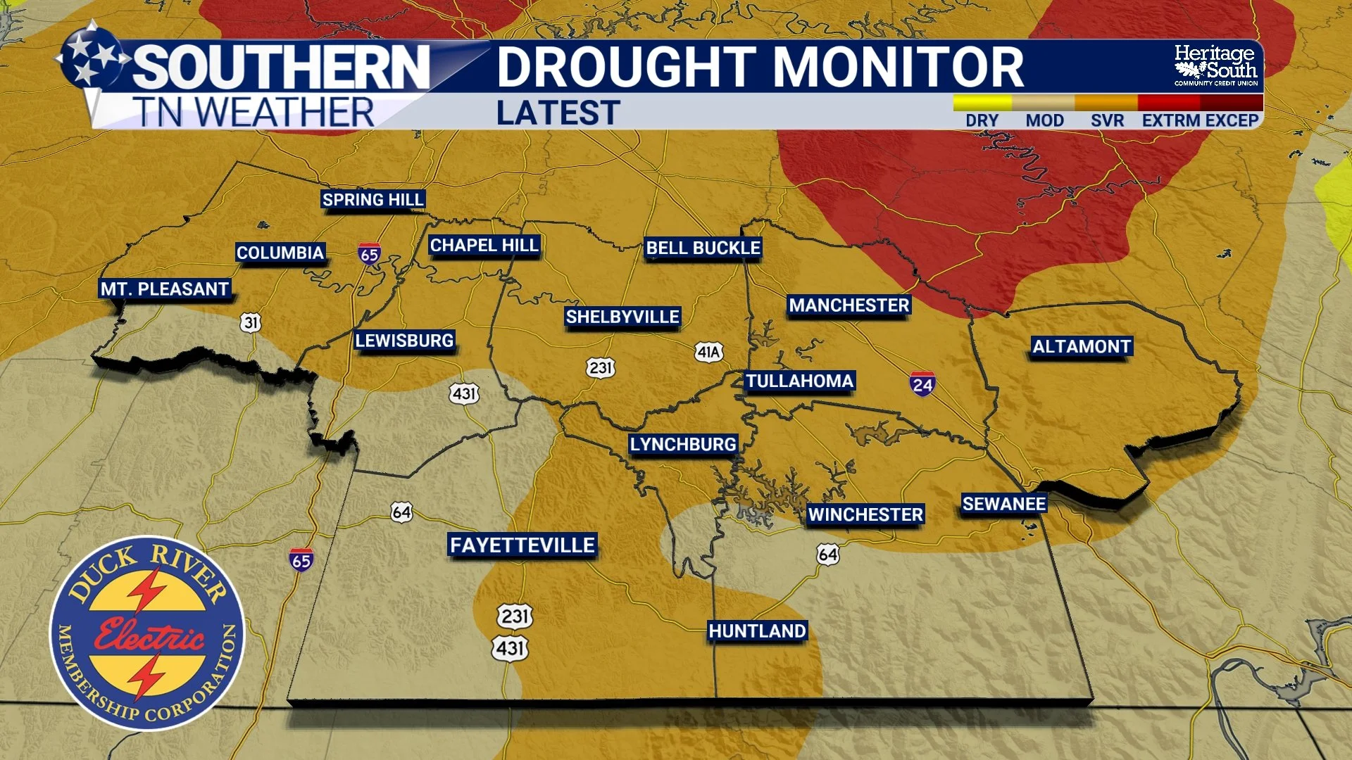
This morning's drought update, which reflects conditions through Tuesday, November 17, paints a rather concerning picture across much of the southern United States. Some areas are continuing to make considerable progress toward drought recovery, while others are experiencing some of their worst drought conditions in years. Here in Tennessee, the improvements we've seen recently haven't necessarily translated into a statewide recovery, with conditions actually deteriorating in some parts of the state.
Let's take a closer look at where things currently stand, how we compare to some of our neighboring states, and whether our upcoming weather pattern could provide another opportunity for meaningful drought relief.
A Closer Look at Drought Conditions Across Tennessee
Despite the beneficial rainfall that fell across portions of Tennessee earlier this month, the overwhelming majority of our state continues to experience some degree of abnormal dryness or drought. In fact, several of our statewide drought statistics have worsened slightly compared to last Thursday's update.
Here's a breakdown of the latest statewide figures, including how they relate to last week:
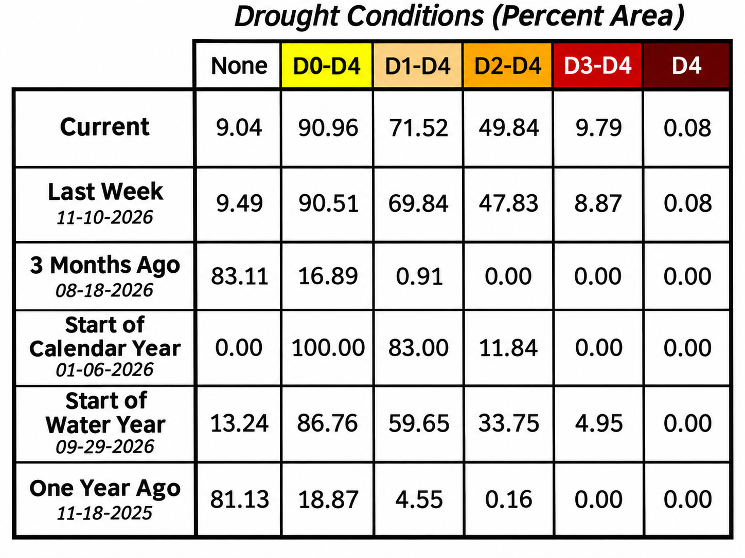
Nearly THREE-QUARTERS of Tennessee is experiencing moderate drought conditions or worse, while approximately half of the state is experiencing severe drought conditions or worse. What's particularly concerning is how rapidly these conditions have developed over the past several months. Just three months ago, less than 1% of Tennessee was experiencing moderate drought, with no portion of the state experiencing severe drought or worse.
Here in Southern Middle Tennessee, the improvements we've seen over the past month can largely be attributed to the rainfall events that occurred during the first week of November. If you recall, several communities received upwards of three inches of rain during that stretch, particularly across portions of Maury, Marshall, and Bedford counties. That rainfall was certainly beneficial, but we're now approaching another two-week stretch with little to no measurable precipitation across much of the region.
Looking at the four-week change in drought intensity across Tennessee, there's a fairly noticeable geographical divide. Several counties along the southern portion of the state have experienced improvements of one or two drought categories, while portions of the Cumberland Plateau and Great Smoky Mountains have experienced deterioration of as many as three categories. Unfortunately, where you live has made a considerable difference in how much beneficial rainfall you've received this fall.
Over the past 30 days, much of the western half of Tennessee has received between three and six inches of rainfall, compared to two inches or less across much of the eastern half of the state. We've also been dealing with generally warmer-than-average temperatures, which haven't necessarily helped our moisture deficits.
Streamflow conditions remain another concern, with observations ranging from normal to substantially below normal across Tennessee. Although recent rainfall has helped, the underlying hydrological impacts of our prolonged dry weather are still present.
Exceptional Drought Continues to Expand Across the South
While our drought conditions here in Southern Middle Tennessee are certainly concerning, the situation becomes considerably more alarming as you travel farther southwest into Arkansas, Louisiana, and Mississippi. All three states continue to experience exceptional drought conditions, which is the highest classification on the U.S. Drought Monitor's five-category scale.
Mississippi experienced a particularly large expansion of exceptional drought across the central portion of the state in this week's update. The lack of meaningful rainfall continues to compound precipitation deficits that have been accumulating for well over a year in some locations.
According to this week's U.S. Drought Monitor discussion, many communities across Arkansas, Louisiana, and Mississippi would need between 20 and 30 inches of rainfall over a three-month period to overcome their existing drought conditions. To put that into perspective, we're talking about roughly seven to ten inches of rainfall per month for three consecutive months. That's an enormous amount of precipitation, even for a portion of the country that typically receives considerable rainfall during the cooler months of the year.
On the other hand, there continues to be encouraging news coming out of Texas. Another round of heavy rainfall impacted central and southeastern portions of the state over the past week, with some communities along the Gulf Coast between Corpus Christi and Houston receiving three to four inches of rain or more. This resulted in additional improvements to the severe and extreme drought conditions that have plagued southeastern Texas. Central Oklahoma also benefited from one to two inches of rainfall, allowing drought conditions to improve there as well.
The contrast between these areas is a good reminder of just how geographically uneven drought recovery can be. While we're all dealing with the broader effects of a relatively dry weather pattern across the southern United States, the tracks of individual storm systems ultimately determine which communities receive much-needed rainfall and which communities continue accumulating precipitation deficits.
What Does the Drought Outlook Look Like Heading Into Winter?
One of the questions I've been interested in lately is whether we'll be able to make substantial progress toward drought recovery during the upcoming winter months. Historically, the cooler months provide a favorable opportunity for replenishing moisture reserves across Southern Middle Tennessee. Evaporation rates generally decrease, vegetation becomes dormant, and more of the precipitation we receive can contribute to soil moisture, groundwater recharge, and streamflow.
However, that obviously requires us to receive meaningful rainfall in the first place!
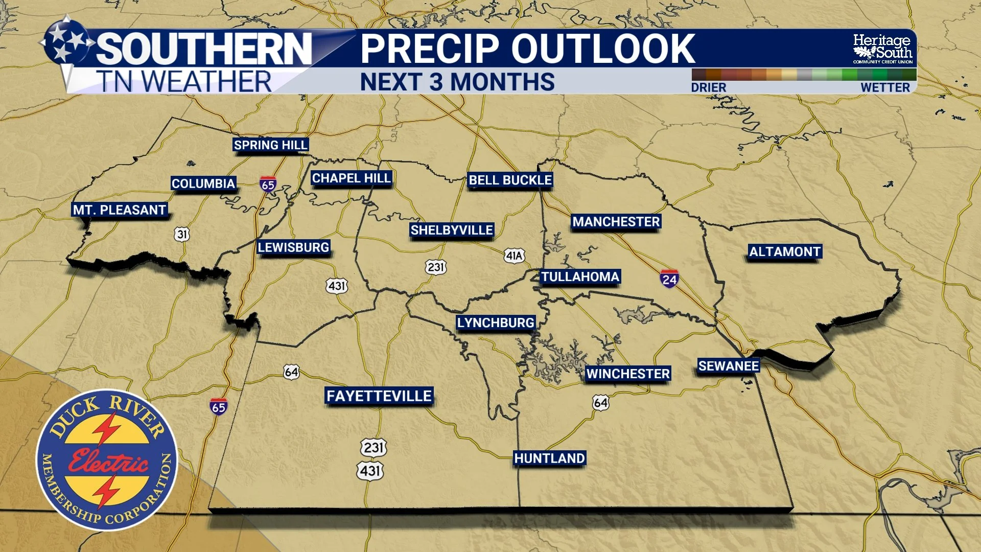
The latest seasonal outlook from the Climate Prediction Center, released this morning and valid for December, January, and February, favors above-average temperatures across Tennessee. As far as precipitation is concerned, the outlook shows our area receiving near or slightly below-average precipitation.
It's important to understand that a seasonal outlook favoring above-average precipitation doesn't automatically mean our drought will come to an end. These outlooks describe the probability of precipitation falling within certain categories over a three-month period, rather than predicting specific rainfall amounts. We could technically experience an above-average winter in the rainfall department and still enter spring with lingering precipitation deficits.
Unfortunately, the latest seasonal drought outlook continues to favor drought persistence through February across drought-affected portions of Tennessee. That doesn't necessarily mean drought conditions will remain at their current intensity throughout the entire winter, but it does suggest that a complete recovery is not currently favored.
I'd certainly love to see that outlook change over the next several weeks, especially as we begin looking ahead toward the 2027 growing season.
When Will It Rain Again Across Southern Middle Tennessee?
Before we get into any potentially significant changes to our weather pattern, we still have a few more days of beautiful, unseasonably warm November weather to enjoy. Afternoon highs will climb into the lower 70s across much of Southern Middle Tennessee today and Friday under mostly sunny skies, with slightly cooler temperatures across the higher elevations of the Cumberland Plateau. Considering our average high temperature for this time of year is around 60 degrees, we're running approximately 10 degrees above normal!
Our next opportunity for rainfall will come late Sunday into early Monday as a cold front and relatively weak upper-level disturbance move through the region. Unfortunately, I'm still not particularly impressed with this system from a drought relief standpoint. Rainfall activity looks isolated to scattered, with totals around a tenth of an inch possible for many of the locations that receive rain. Some communities may miss out altogether.
The latest seven-day precipitation outlook continues to favor totals below half an inch across Tennessee. While any rainfall is certainly welcome at this point, we're going to need considerably more than that to make another meaningful dent in our drought conditions.
Beyond Monday, however, things start getting a little more interesting. As we discussed in yesterday's educational weather blog, the jet stream plays an incredibly important role in determining how active our weather pattern becomes. We're beginning to see indications that the upper-level flow could become more active across our portion of the country heading into Thanksgiving week and the following weekend, potentially allowing additional storm systems to move through the region.
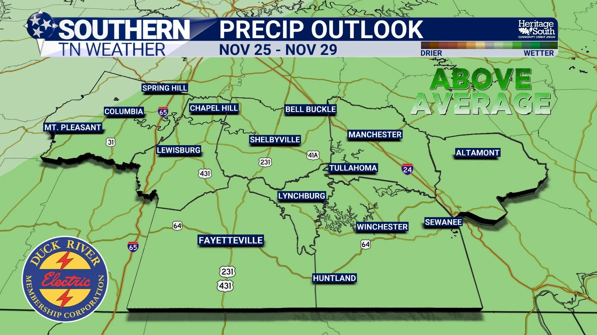
The Climate Prediction Center's latest eight-to-fourteen-day outlook, valid from Thanksgiving Day through December 2, also offers some encouragement, with portions of Tennessee leaning toward above-average precipitation.
At this range, I'm much more interested in the overall evolution of the upper-level weather pattern than the exact timing or rainfall totals associated with individual storm systems. Forecast guidance will inevitably fluctuate considerably over the next several days, but the broader signal for a potentially more active pattern is certainly something worth keeping an eye on.
Of course, a more active weather pattern doesn't guarantee a widespread, soaking rainfall, and I'm not quite ready to make any promises just yet. Nevertheless, I'm a little more optimistic about our rainfall opportunities heading into the final days of November than I've been over the past couple of weeks. Stay tuned!
The Bottom Line 🧾
Nearly 91% of Tennessee is experiencing abnormal dryness or drought.
Approximately half of the state is experiencing severe drought or worse.
Recent rainfall has improved drought conditions across portions of Southern Middle Tennessee, but considerable moisture deficits remain.
Exceptional drought continues to expand across portions of Arkansas, Louisiana, and Mississippi.
Our next opportunity for light rainfall arrives late Sunday into early Monday.
A potentially more active weather pattern heading into Thanksgiving week and early December offers some encouragement.
The latest seasonal drought outlook continues to favor drought persistence through February.
📰 Reminder: The Southern Tennessee Weather Blog, presented by Heritage South Community Credit Union, is updated Monday through Friday with fresh, locally tailored forecasts you can trust
