
Weekend Outlook: BEAUTIFUL Fall Weather on Tap Across Southern Middle Tennessee!

The Southern Tennessee Weather Blog is proudly presented by Heritage South Community Credit Union.
We Help When Others Won’t!
Visit https://www.heritagesouth.org/ today to see how HSCCU can help YOU!
GOT ANY OUTDOOR PLANS THIS WEEKEND? WELL, YOU COULDN'T HAVE PICKED A MUCH BETTER ONE! Southern Middle Tennessee is in for another absolutely BEAUTIFUL stretch of autumn weather, with plenty of sunshine, comfortable afternoon temperatures, and crisp, chilly mornings. Whether you're heading to a high school football game tonight, visiting a local pumpkin patch, getting some yard work done, or simply enjoying a little time outside, Mother Nature is certainly cooperating!
We're talking afternoon highs generally in the 70s, overnight lows in the 40s, and virtually ZERO chance of rainfall throughout the entire weekend. Winds should also remain relatively light, making for some fantastic conditions for just about any outdoor activity. And honestly, after the heat and humidity we endured earlier this year, it's hard to complain about weather like this!
However, there's one important concern that continues to linger beneath all this beautiful sunshine: OUR ONGOING DROUGHT. While the weather looks nearly perfect for outdoor activities, the lack of rainfall is becoming increasingly problematic across Southern Middle Tennessee. And unfortunately, there's still no meaningful rain in sight for at least the next seven days. But first, let's take a closer look at what you can expect heading into the weekend!
Friday Night Lights: PERFECT Football Weather!
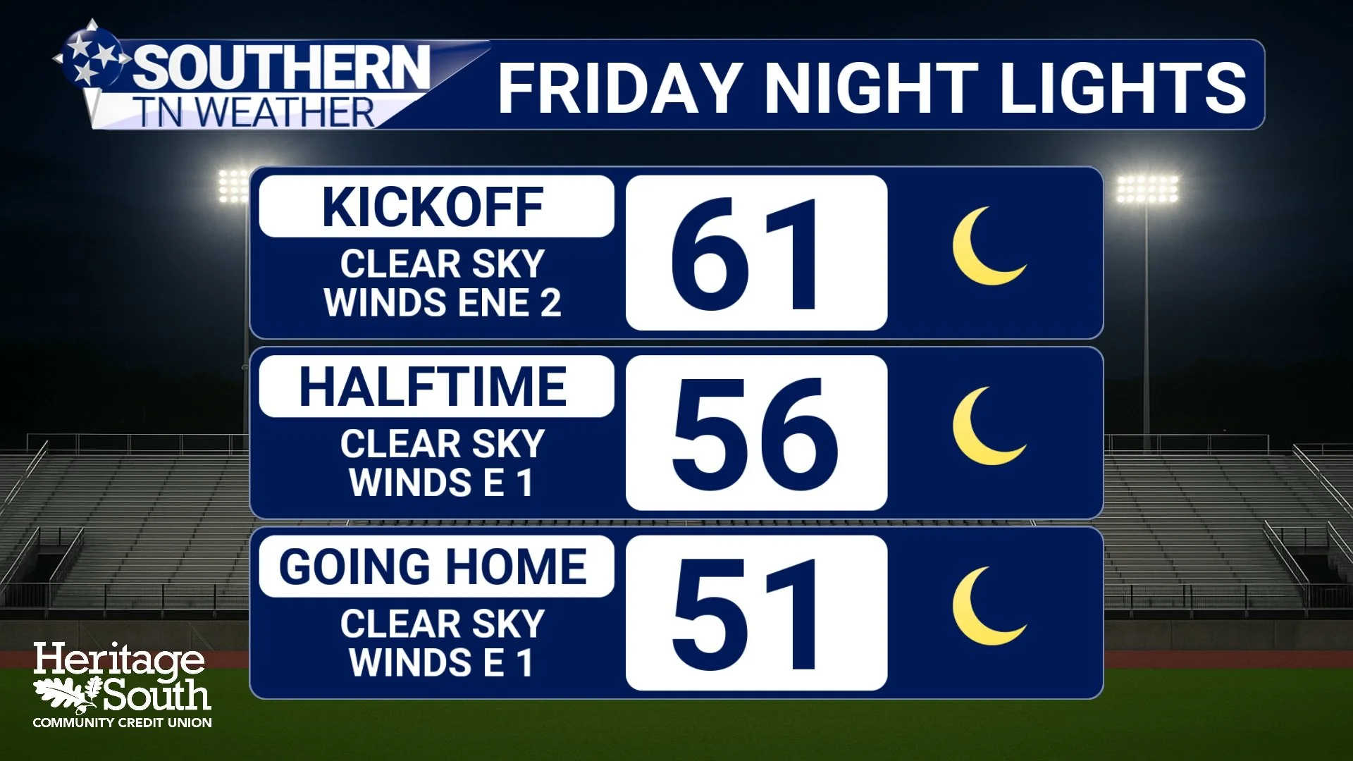
If you're heading out to support your favorite high school football team tonight, you might want to grab a light jacket before leaving the house. We're expecting a beautiful evening across Southern Middle Tennessee, with clear skies, relatively light winds, and temperatures gradually cooling after sunset.
Afternoon highs should climb into the middle to upper 70s today, but once the sun goes down, temperatures will begin dropping fairly quickly. By kickoff, many communities should be settling into the lower 60s, with temperatures falling into the 50s as we progress through halftime and the final whistle.
And here's something the kickers will certainly appreciate: Winds should remain relatively light throughout the evening! We aren't expecting any particularly gusty conditions, so the weather should have very little influence on tonight's games. No excuses for missing that field goal, fellas! 😂
The combination of clear skies, light winds, and dry air will also allow temperatures to continue falling overnight. By Saturday morning, most of us should wake up to temperatures in the 40s, with some of our sheltered valleys and low-lying communities potentially dropping into the lower 40s. That's what I call TRUE football weather!
Saturday: Another BEAUTIFUL Autumn Afternoon!
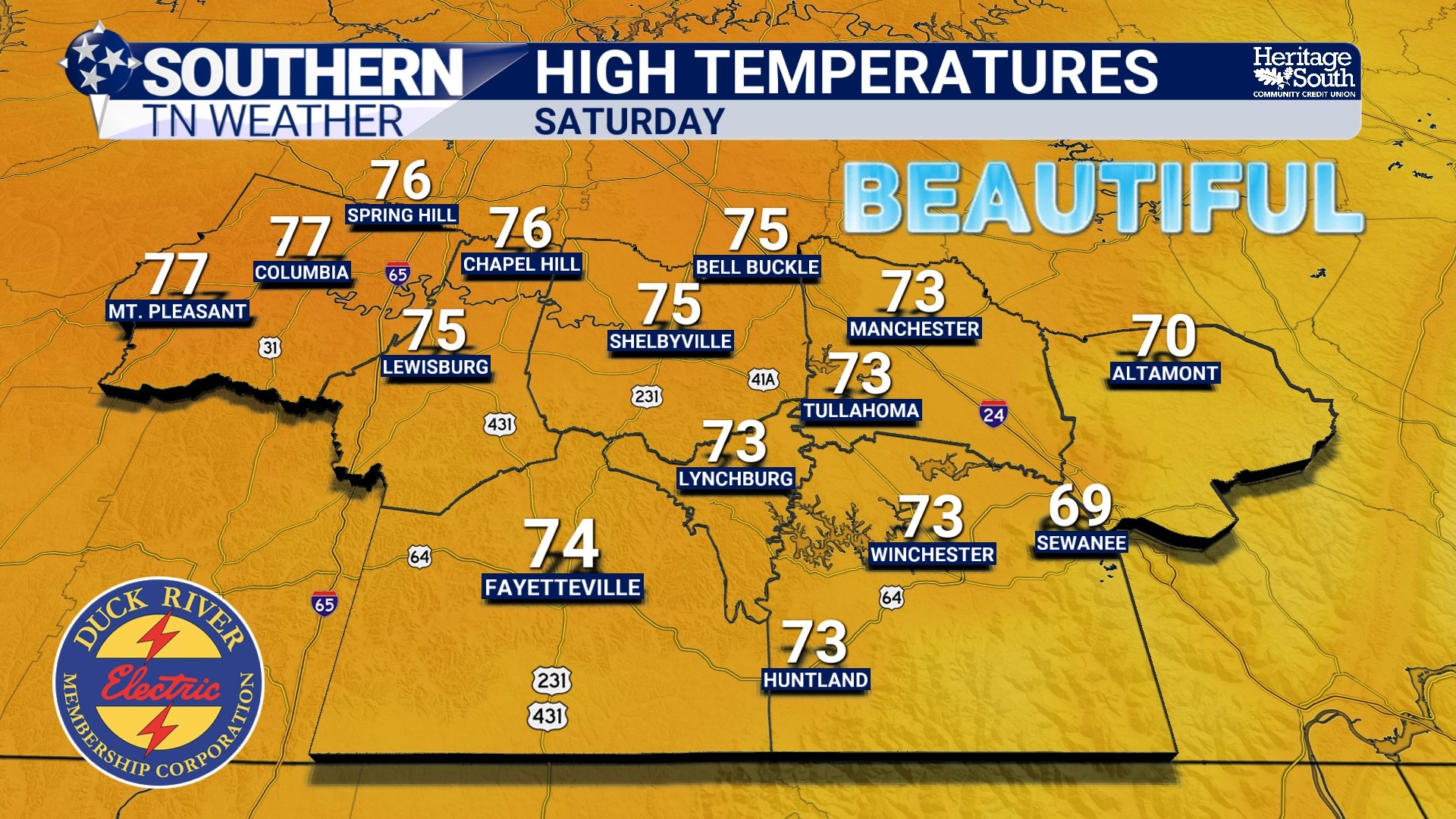
Saturday is shaping up to be an absolutely fantastic day across Southern Middle Tennessee. We'll wake up to chilly temperatures in the 40s before abundant sunshine allows readings to warm comfortably through the morning and afternoon. High temperatures should generally reach the middle 70s, although some of our warmer communities could climb into the upper 70s. A few locations may even approach 80 degrees, depending on how much influence our persistent upper-level ridge has on afternoon temperatures.
Interestingly, there's a little bit of uncertainty surrounding exactly how warm we'll become this weekend. A strong atmospheric ridge will continue building eastward across portions of the central and southeastern United States, generally favoring warmer temperatures and dry weather. However, a weak push of cooler air from the east could partially offset that warming, especially across some of our eastern communities.
In other words, don't be surprised if afternoon temperatures end up running a few degrees warmer than forecast in certain locations. Regardless, we're looking at another very pleasant day with sunshine, comfortable temperatures, and relatively light winds.
Saturday evening will be equally nice, with temperatures gradually cooling through the 60s and eventually into the 50s after sunset. By early Sunday morning, most of us should be back in the lower to middle 40s, although some higher elevations and exposed ridges may remain a little warmer. If you've got plans to visit a pumpkin patch, attend a fall festival, or spend some time outside, Saturday looks like a WINNER!
Sunday: More of the Same... And That's Not a Bad Thing!
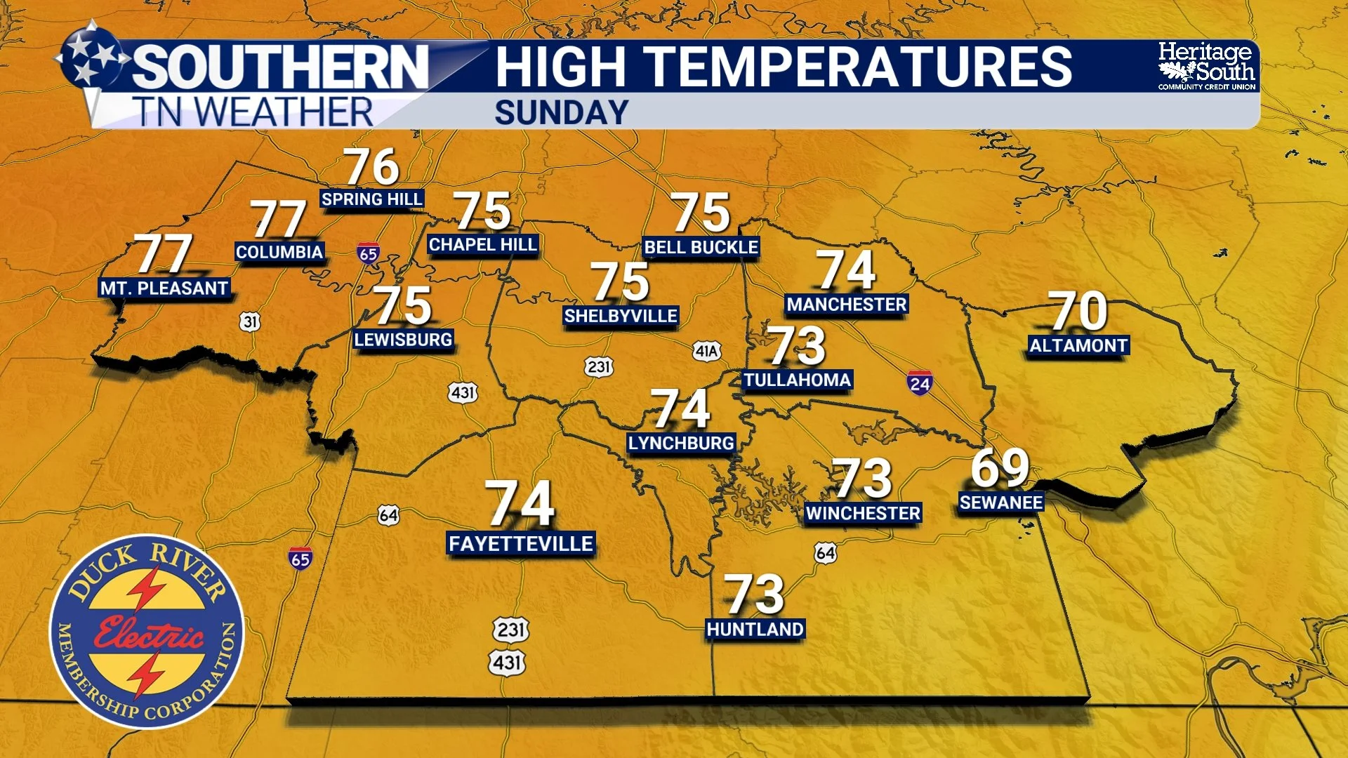
If Saturday's forecast sounds good to you, I've got some excellent news. Sunday is shaping up to be almost identical! Expect another chilly start with temperatures generally in the 40s, followed by plenty of sunshine and afternoon highs climbing into the 70s. Once again, some locations could approach the upper 70s, depending on how the upper-level ridge and cooler easterly flow interact across our region.
There may be a few subtle differences in temperatures from one community to another, especially between our lower elevations and areas closer to the Cumberland Plateau. However, those differences shouldn't have much impact on outdoor activities. For the vast majority of Southern Middle Tennessee, Sunday looks like another beautiful autumn day.
And here's the best part: We're expecting absolutely NO organized rainfall throughout the weekend! No thunderstorms to dodge, no soaking showers to interrupt your plans, and no significant weather systems moving through our coverage area. Of course, while that's fantastic news for anyone hoping to enjoy the outdoors, it brings us right back to the biggest concern in our forecast.
The One Downside: Our Drought Continues to Worsen
As beautiful as our weather has been recently, we desperately need some meaningful rainfall across Southern Middle Tennessee. The latest U.S. Drought Monitor continues to show widespread Moderate to Severe Drought across much of our coverage area, with pockets of Extreme Drought affecting portions of the region. And unfortunately, this weekend's forecast isn't going to help.
A broad area of high pressure remains established across much of the eastern United States, maintaining a very dry and stable atmosphere. This system is helping suppress widespread cloud development and meaningful rainfall, while an upper-level ridge continues influencing the larger-scale weather pattern. The result is an extended stretch of sunny days, cool nights, and virtually no precipitation. And while temperatures aren't particularly hot, the lack of rainfall is allowing soil moisture deficits to continue accumulating.
Another concern involves our exceptionally dry afternoon air. Relative humidity values have recently fallen into the 20–25% range across portions of the region, and additional periods of low humidity are possible this weekend. When relative humidity becomes that low, fine vegetation such as fallen leaves, dead grass, and small twigs can lose moisture relatively quickly. That becomes especially important during October, when leaves are beginning to accumulate across the ground and Tennessee's fall wildfire season is getting underway.
Thankfully, winds should remain relatively light throughout the weekend, which will help limit the potential for rapidly spreading, wind-driven fires. However, LIGHT WINDS DO NOT MEAN ZERO FIRE DANGER! With vegetation becoming increasingly dry, even a relatively small fire could become difficult to control under the wrong circumstances. If you're planning to clean up leaves, work around dry vegetation, or spend time outdoors this weekend, please be especially careful with anything that could produce sparks or open flames. And before conducting any outdoor burning, make sure to check for applicable restrictions and local regulations. We can certainly enjoy this beautiful weather while still being mindful of the increasingly dry conditions around us.
Why Has Our Weather Been So Consistent?
At this point, I think we've all noticed that our forecast has become rather repetitive. Sunshine, highs in the 70s, chilly mornings, and absolutely no rainfall. Day after day after day! The reason involves a persistent combination of surface high pressure and an atmospheric ridge several miles above the ground. These features have helped maintain a relatively stable atmosphere across Southern Middle Tennessee, making it difficult for organized storm systems to bring meaningful rainfall into our region.
High pressure is often associated with sinking air, which tends to warm and dry as it descends through the atmosphere. This process makes widespread cloud development more difficult, especially when the atmosphere already contains very little moisture. Meanwhile, the upper-level ridge is influencing the larger-scale atmospheric circulation, helping maintain our remarkably consistent temperatures and dry conditions. Even though the ridge will gradually shift and evolve over the next several days, the overall pattern isn't expected to change enough to produce significant rainfall across our area.
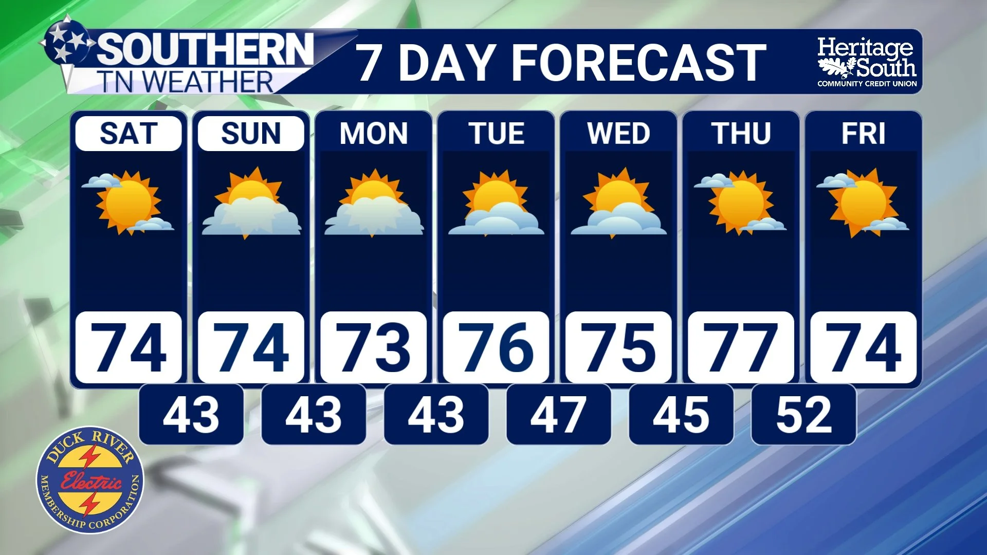
That's why our seven-day forecast looks almost identical from one day to the next. We simply don't have a strong enough weather system, sufficient atmospheric moisture, or favorable lifting mechanisms to produce meaningful precipitation. And unfortunately, that pattern looks likely to continue into next week.
Could We FINALLY See Some Rain as November Approaches?
Now, here's where things get a little more interesting. While our weekend forecast is about as straightforward as it gets, there are some early indications that the larger-scale atmospheric pattern could begin evolving as we head toward the end of October and the beginning of November.
Our persistent upper-level ridge may begin weakening early next week as a disturbance moves out of the southwestern United States and into the Plains and Ohio Valley. A portion of that disturbance could move through the broader region around Tuesday or Wednesday, potentially bringing some changes to the atmospheric circulation. However, there's one BIG problem: THE ATMOSPHERE IS STILL EXPECTED TO BE TOO DRY TO SUPPORT MEANINGFUL RAINFALL!
Even if a disturbance moves through our region, it won't necessarily produce precipitation unless sufficient moisture is available. And right now, forecast guidance continues suggesting that our atmosphere will remain exceptionally dry through much of next week. Temperatures may cool slightly on Monday, with highs generally in the upper 60s to lower 70s in some communities, before climbing back into the lower to middle 70s Tuesday and Wednesday. Overnight lows should remain in the 40s, gradually moderating toward the middle 40s to around 50 degrees by the middle of next week.
Looking a little farther ahead, there are some encouraging signals that our stubborn ridge could weaken enough to allow better rainfall opportunities as we transition into November. However, confidence remains limited, and there's still no guarantee that any meaningful rainfall will materialize. For now, the forecast remains dry for at least the next seven days, and drought conditions are expected to continue worsening.
The Bottom Line 🧾
☀️ A BEAUTIFUL fall weekend is on tap! Expect abundant sunshine and comfortable afternoon temperatures across Southern Middle Tennessee.
🏈 Friday Night Lights look FANTASTIC! Clear skies, light winds, and temperatures falling from the lower 60s around kickoff into the 50s later in the evening.
🍂 Saturday and Sunday will feature highs generally in the 70s, with some warmer communities potentially approaching 80 degrees.
🧥 Mornings will remain chilly, with overnight lows generally in the 40s. Some sheltered valleys could be a little cooler than surrounding ridges.
🌧️ No meaningful rainfall is expected this weekend, and the dry pattern will likely continue for at least another seven days.
🌵 Our ongoing drought remains a serious concern, with widespread Moderate to Severe Drought and pockets of Extreme Drought across portions of our coverage area.
🔥 Fire danger deserves attention, especially during afternoons featuring low relative humidity and increasingly dry vegetation.
🌎 High pressure and an upper-level ridge will continue dominating our weather, keeping conditions remarkably consistent.
👀 A potential pattern change may develop as we head into November, but meaningful rainfall remains uncertain.
📰 Reminder: The Southern Tennessee Weather Blog, presented by Heritage South Community Credit Union, is updated Monday through Friday with fresh, locally tailored forecasts you can trust.
