
Drought Conditions Continue to Worsen Across Southern Middle Tennessee

The Southern Tennessee Weather Blog is proudly presented by Heritage South Community Credit Union.
We Help When Others Won’t!
Visit https://www.heritagesouth.org/ today to see how HSCCU can help YOU!
ANOTHER THURSDAY, ANOTHER DROUGHT MONITOR UPDATE... AND UNFORTUNATELY, THE NEWS ISN'T GETTING ANY BETTER! The latest U.S. Drought Monitor has been released, and Southern Middle Tennessee continues to struggle with widespread drought conditions following weeks of below-normal rainfall and unusually warm weather. Moderate to Severe Drought remains a significant concern across our coverage area, with pockets of Extreme Drought still affecting portions of the region. And perhaps the most frustrating part? There's virtually NO meaningful rainfall in our forecast for at least the next seven days.
If you've been enjoying our beautiful autumn weather recently, you're certainly not alone. Sunshine, afternoon highs in the 70s, and chilly mornings in the 40s have made for some absolutely fantastic conditions across Southern Middle Tennessee. However, all this pleasant weather is coming at a cost. Our soils are continuing to dry out, vegetation is becoming increasingly stressed, and the potential for brush fires and other outdoor fires is becoming a growing concern.
The latest drought update, valid Tuesday, October 20, shows that drought conditions remain firmly established across much of our region. While some locations benefited from rainfall earlier this month, including precipitation associated with the remnants of Hurricane Isaias, that moisture wasn't nearly enough to erase the deficits that have accumulated over the past several weeks and months. And with our stubborn high-pressure pattern showing very little indication of changing, the situation is likely to become even more concerning as we approach November.
What Does the Latest Drought Monitor Show Across Our Area?
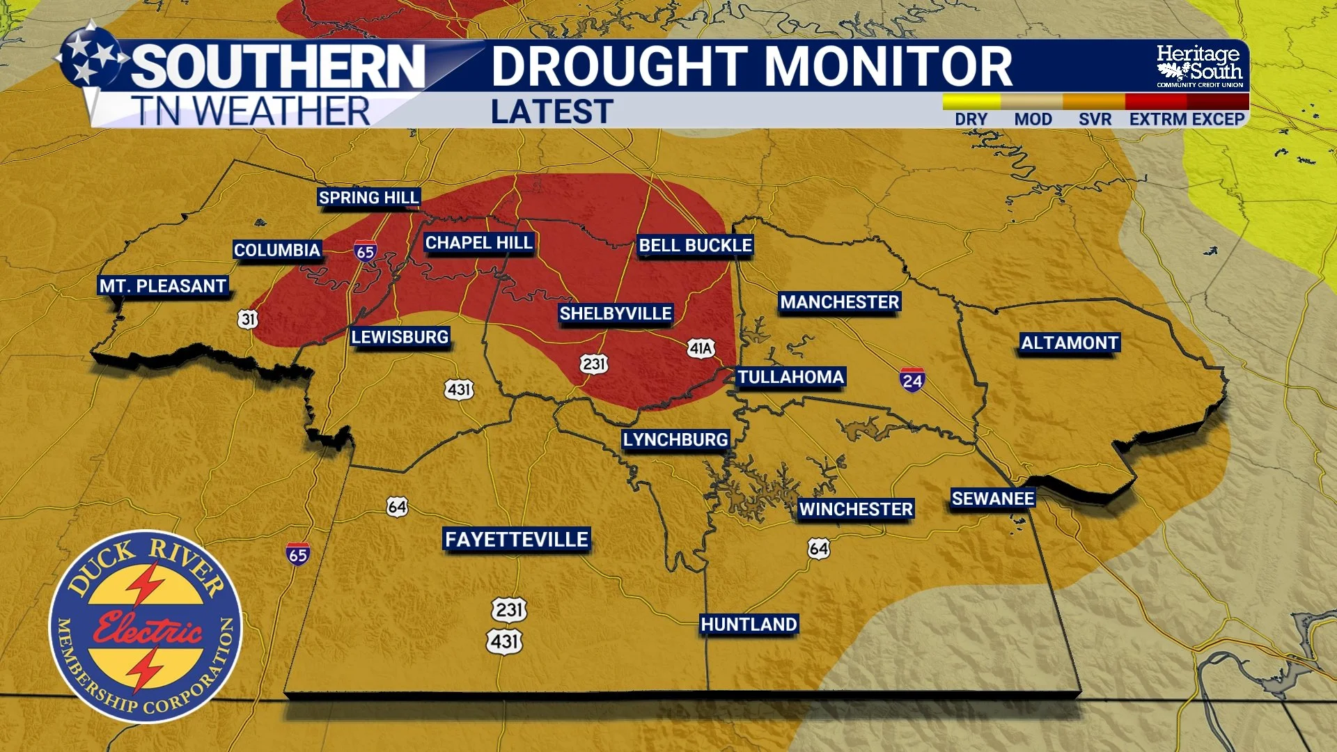
Looking at the latest drought map, the biggest takeaway for Southern Middle Tennessee is that widespread Moderate to Severe Drought continues, with pockets of Extreme Drought affecting portions of our coverage area. Conditions vary from county to county, and even within individual counties, depending on recent rainfall, soil moisture, and other drought indicators. Across portions of Maury, Marshall, Bedford, and Moore counties, drought conditions remain particularly concerning, with some areas experiencing Extreme Drought. Farther east, including portions of Coffee, Franklin, and Grundy counties, conditions are generally less intense, although drought and abnormally dry conditions remain an issue across much of the region.
It's important to understand that the drought classifications on the map aren't simply based on how long it's been since a particular community received rainfall. The U.S. Drought Monitor considers a variety of factors, including recent precipitation, longer-term rainfall deficits, soil moisture, streamflow, vegetation conditions, and reports of drought impacts. That's why two nearby communities can fall into different drought categories even when they've experienced similar weather over the past several days.
And while the latest statewide map does show Exceptional Drought developing in a small portion of West Tennessee, that highest drought classification is NOT currently affecting Southern Middle Tennessee. Our local concern remains the widespread Moderate and Severe Drought, along with the areas already experiencing Extreme Drought. Unfortunately, those conditions are serious enough on their own, especially considering the lack of rainfall in our upcoming forecast. One particularly concerning aspect of the latest update is how quickly drought intensity has been increasing across Tennessee. The portion of the state experiencing Severe Drought or worse has climbed from 36.93% last week to 48.15% this week. Meanwhile, Extreme Drought or worse has expanded from 7.46% to 18.80% statewide. Those numbers demonstrate just how quickly drought conditions can deteriorate when prolonged rainfall deficits combine with warmer-than-normal temperatures.
Although those percentages represent Tennessee as a whole rather than our individual counties, they reinforce the broader concern that drought conditions are intensifying across much of the state. Here in Southern Middle Tennessee, we're certainly not immune to that trend.
Why Is Our Drought Continuing to Worsen?
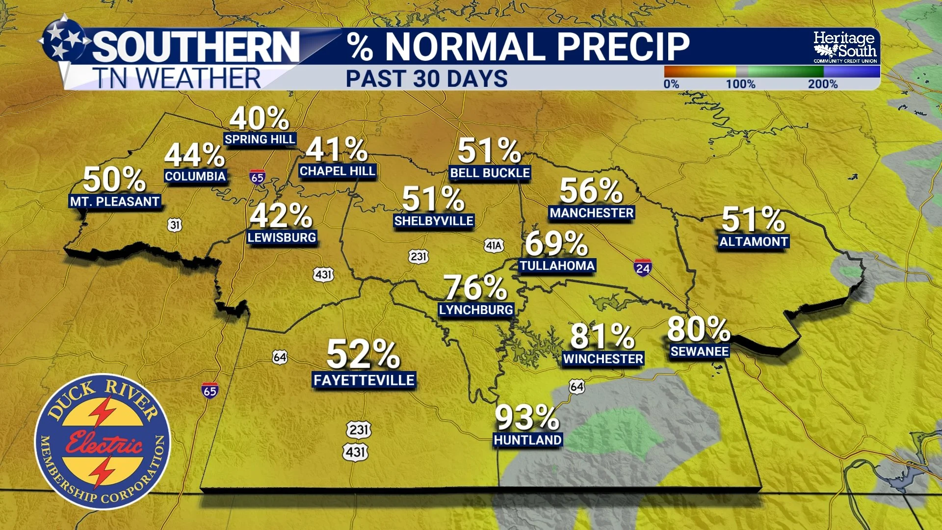
The answer is relatively straightforward: We simply haven't received enough rainfall to keep up with what our region normally needs this time of year. Over the past 30 days, much of Middle Tennessee has received two inches of rainfall or less, with many locations experiencing precipitation totals around 50% of normal or lower. At the same time, temperatures across Tennessee have generally averaged approximately 2–6 degrees above normal during that period. That combination of warmer weather and below-normal rainfall has helped accelerate the drying of soils and vegetation.
Now, some of you may be thinking back to the rainfall we received earlier this month when Hurricane Isaias moved inland from the Gulf. And you're absolutely right! That system did bring some beneficial rainfall to Southern Middle Tennessee, with many communities picking up around an inch of rain. However, one decent rainfall event simply isn't enough to erase the effects of an extended dry period.
Think of our soil moisture like a bank account. Every time it rains, we're making a deposit. But when we go weeks without meaningful precipitation, moisture continues being withdrawn through evaporation, plant water use, and other natural processes. Eventually, those withdrawals begin exceeding the deposits, and the account starts running low. A single rainfall event might provide a temporary boost, but it doesn't necessarily restore everything that's been lost. That's essentially what's happening across our region right now. We received some much-needed moisture earlier this month, but our prolonged dry weather pattern has quickly returned. Without additional rainfall, the upper layers of the soil will continue drying out, and the longer-term moisture deficits will become increasingly difficult to overcome.
Another important factor is the time of year. Although cooler autumn temperatures generally reduce evaporation compared with the middle of summer, we can still experience significant drying during extended periods of sunshine, low humidity, and little rainfall. And that's exactly the pattern we're currently dealing with.
Fire Danger Is Becoming an Increasing Concern
One of the biggest concerns associated with our ongoing drought is the increasing potential for brush fires, field fires, and wildfires. October marks the beginning of Tennessee's traditional fall wildfire season, and our current weather pattern is creating increasingly favorable conditions for vegetation to dry out. During the afternoon hours, relative humidity values are expected to fall into the 20–25% range in portions of Southern Middle Tennessee. That's exceptionally dry air, especially when combined with the ongoing drought and the abundance of dry grasses, leaves, and other vegetation across our region.
But what exactly does relative humidity have to do with fire danger? Relative humidity describes how close the air is to saturation at its current temperature. When relative humidity becomes very low, the atmosphere can more readily draw moisture from exposed materials, including fine vegetation such as dead grass and fallen leaves. As those materials dry out, they become easier to ignite. Thankfully, winds are expected to remain relatively light over the next several days, which should help limit the potential for rapidly spreading, wind-driven fires. However, light winds don't completely eliminate the danger. Fires can still ignite and spread under dry conditions, particularly in areas with abundant dead vegetation or other combustible materials.
And as we move closer to November, the concern may become even more significant. The latest wildland fire potential outlook indicates that much of Tennessee could experience above-normal significant fire potential during November. That doesn't mean widespread wildfires are guaranteed, but it does suggest that our ongoing drought could become increasingly problematic if meaningful rainfall doesn't return. I'd strongly encourage everyone to avoid unnecessary outdoor burning and use additional caution around equipment that produces sparks, discarded cigarettes, and other potential ignition sources. A small fire can become a much bigger problem when vegetation is exceptionally dry, and the last thing we need right now is a preventable wildfire.
Our Seven-Day Forecast: Sunshine, 70s, and Absolutely NO Rainfall
Unfortunately, there's very little encouragement in our immediate weather forecast. A broad area of high pressure remains firmly established across much of the eastern United States, keeping our atmosphere dry and stable. This pattern has been responsible for our seemingly endless stretch of sunshine and comfortable temperatures, and it shows very little indication of breaking down anytime soon.
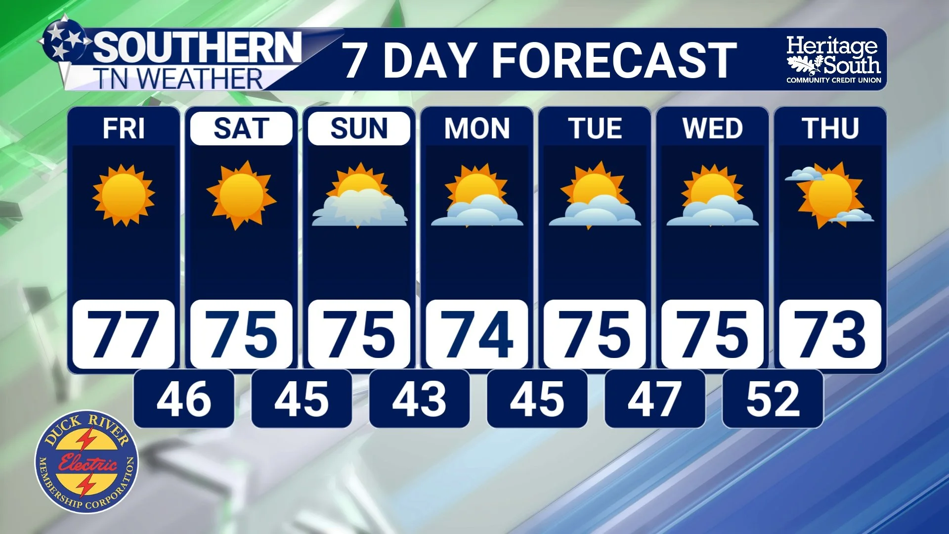
Thursday: Another beautiful autumn afternoon is underway, with abundant sunshine and temperatures generally climbing into the middle to upper 70s. Some of our warmer communities could approach 80 degrees, particularly across western and southern portions of the region. Afternoon relative humidity values may fall into the 20–25% range, so fire safety remains important despite relatively light winds. Tonight will be clear and chilly, with lows generally in the lower to middle 40s in our sheltered valleys and low-lying areas. Higher elevations and ridges may remain a little warmer, generally in the middle 40s to around 50 degrees.
Friday: Expect another sunny and pleasant afternoon, with highs generally in the middle to upper 70s. The atmosphere will remain exceptionally dry, and afternoon humidity values could once again become quite low. Friday night will feature clear skies and chilly temperatures, with lows generally in the 40s.
Saturday and Sunday: Our beautiful autumn weather will continue through the weekend, with plenty of sunshine and afternoon highs generally in the 70s. Some locations could approach 80 degrees, although a slightly more easterly wind component may keep certain communities a little cooler. Overnight lows will generally remain in the 40s, and no meaningful rainfall is expected.
Monday: A slightly cooler influence may develop across portions of our coverage area as the surface high-pressure pattern evolves. Afternoon highs should generally range from the upper 60s to lower 70s in some eastern communities, with temperatures closer to the lower or middle 70s elsewhere. Skies should remain mostly sunny, with overnight lows generally falling into the lower to middle 40s.
Tuesday and Wednesday: A disturbance moving through the larger-scale atmospheric pattern may begin weakening our persistent ridge, but the atmosphere is still expected to remain too dry to support meaningful precipitation. Afternoon highs should generally remain in the lower to middle 70s, with overnight lows gradually moderating into the middle 40s to around 50 degrees.
The bottom line is that no meaningful rainfall is expected across Southern Middle Tennessee for at least the next seven days, and there's a very real possibility that our dry weather pattern could continue even longer. That's certainly not the news we want to hear as drought conditions continue worsening.
Is There Any Hope for Rainfall as We Head Into November?
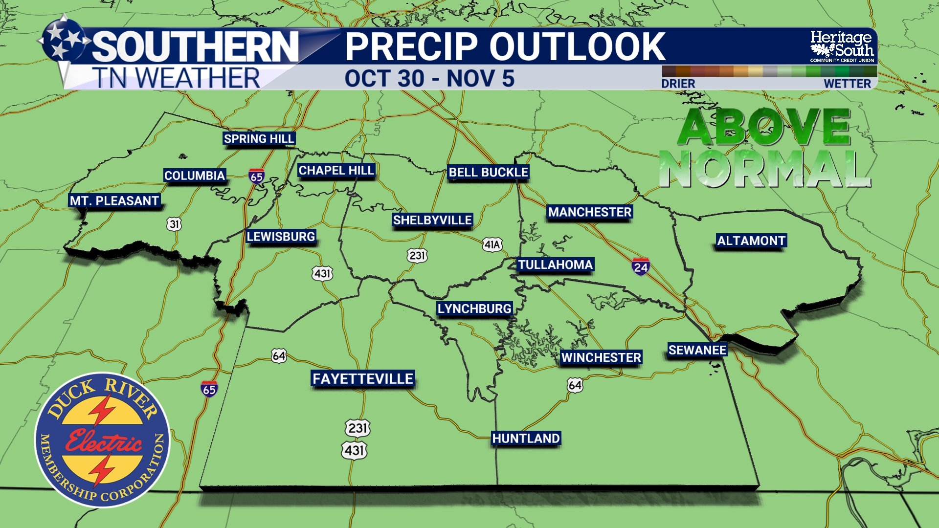
Now, before we get too discouraged, there is at least a little encouraging news when we look beyond the immediate forecast. While the next seven days look essentially rain-free, some longer-range guidance suggests our stubborn atmospheric ridge could begin weakening as we transition into November. That could eventually allow more organized weather systems to move into our region, potentially bringing better opportunities for rainfall.
The latest 8–14 day outlook, covering October 29 through November 4, indicates a 40–50% probability of above-normal precipitation across Tennessee. It also favors above-normal temperatures, with probabilities around 60–70%. However, I want to emphasize that these are longer-range outlooks, NOT guarantees of rainfall. A 40–50% probability of above-normal precipitation doesn't mean there's a 40–50% chance of rain every day, and it certainly doesn't guarantee that we'll receive enough rainfall to improve our drought. Instead, it reflects a modest tilt toward wetter-than-normal conditions over that particular period.
Looking even farther ahead, the seasonal outlook for November through January generally favors near- to above-normal precipitation across Tennessee. There's also some indication that drought conditions could gradually improve later this fall and into early winter if those wetter conditions materialize. That's encouraging, but seasonal outlooks describe broad probabilities over extended periods rather than predicting exactly when individual storm systems will arrive or how much rainfall we'll receive in any particular community. For now, drought conditions are expected to persist over the next several weeks, with any meaningful improvement more likely to occur once our larger-scale weather pattern becomes more favorable for widespread precipitation. And after looking at the latest drought map, I think we can all agree that a pattern change can't come soon enough!
The Bottom Line 🧾
🌵 Moderate to Severe Drought remains widespread across Southern Middle Tennessee, with pockets of Extreme Drought affecting portions of our coverage area.
📍 Maury, Marshall, Bedford, and Moore counties remain among the areas of concern, while drought conditions are generally less intense farther east.
🚨 Exceptional Drought is NOT currently affecting Southern Middle Tennessee. That classification is confined to a small portion of West Tennessee.
🌧️ Much of Middle Tennessee has received two inches of rainfall or less over the past 30 days, generally around 50% of normal or lower.
🔥 Fire danger remains a growing concern, with afternoon relative humidity values potentially falling into the 20–25% range.
☀️ The next seven days look essentially rain-free, with mostly sunny skies, highs generally in the 70s, and overnight lows in the 40s.
📉 Drought conditions are expected to continue worsening without additional meaningful rainfall.
👀 There is some hope for a wetter pattern heading into November, but confidence in substantial drought relief remains limited.
💧 Meaningful drought recovery will require sustained, beneficial rainfall, not simply one isolated rain event.
📰 Reminder: The Southern Tennessee Weather Blog, presented by Heritage South Community Credit Union, is updated Monday through Friday with fresh, locally tailored forecasts you can trust.
