
A Weak Front, A Brief Cooldown… Then Warmth Reloads

The Southern Tennessee Weather Blog is proudly presented by Heritage South Community Credit Union.
We Help When Others Won’t!
Visit https://www.heritagesouth.org/ today to see how HSCCU can help YOU!
At first glance, the forecast across Southern Middle Tennessee doesn’t look all that dramatic. We’re warm today, a weak front comes through tomorrow, and then we settle back into quiet weather. But underneath that simple surface story, there are some important atmospheric processes at play — and they help explain both why today is so warm and why tomorrow’s system is so underwhelming.
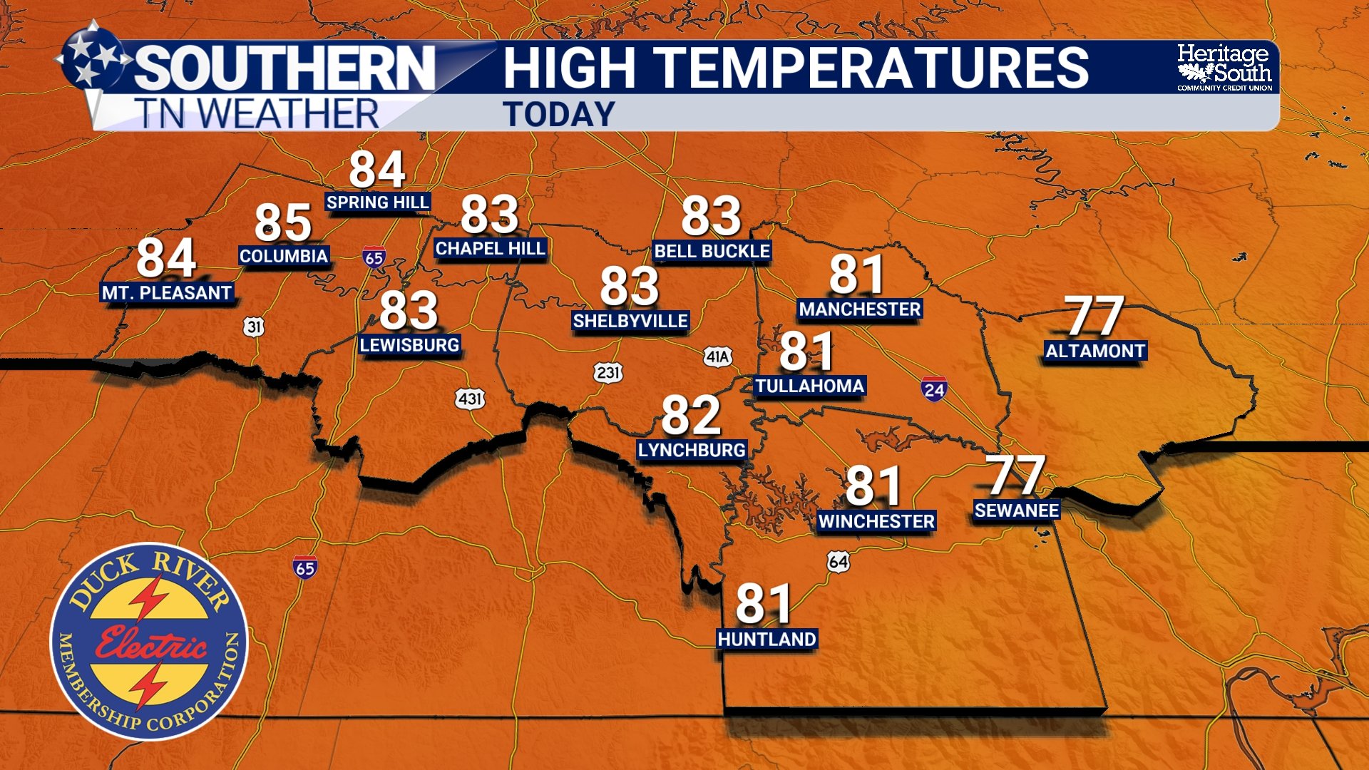
Why Today Feels More Like Late April
Temperatures this afternoon are climbing into the low to mid 80s, putting us right in line with record highs for late March. This kind of warmth isn’t just about sunshine. It’s being driven by a combination of warm air advection and a strengthening ridge aloft. Southerly winds ahead of an approaching front are transporting warmer air northward, while at the same time, rising heights at the 500mb level (roughly 18,000 feet up) are signaling the expansion of an upper-level ridge.
That ridge promotes sinking air, which compresses and warms as it descends. This process, combined with strong daytime mixing, allows that warmth to efficiently reach the surface. It’s why temperatures today are running 20+ degrees above normal in some spots — and why this warmth feels so persistent.
The Front on Friday
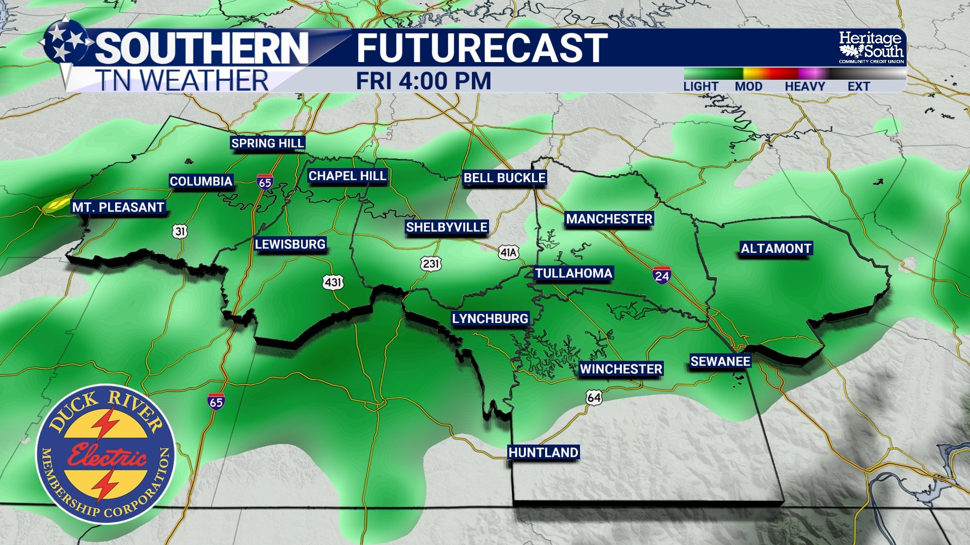
A cold front will move through the region on Friday, but it’s not the kind of system that brings widespread rain or storms. The key reason is lack of atmospheric support. For more impactful weather, you typically need:
Strong lift (forcing)
Adequate moisture
Instability
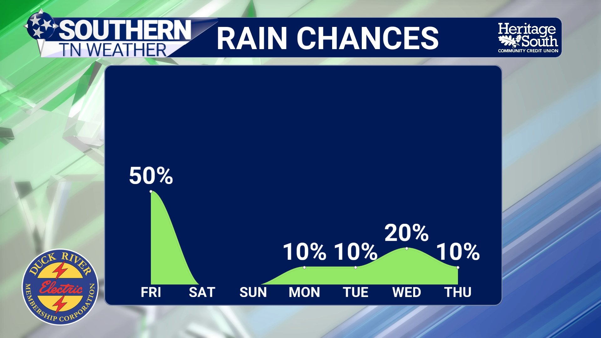
This system checks only one of those boxes (lift) and even that is marginal. The front itself is fairly shallow, and the best upper-level dynamics remain well to our north. At the same time, instability is minimal, and lapse rates are poor, meaning the atmosphere isn’t very efficient at producing rising motion. As a result, most of the precipitation will be in the form of light showers along and behind the front, rather than organized thunderstorms. I expect most of our area to see at least scattered showers between noon and 6 PM tomorrow. Rainfall totals will mostly be under a tenth of an inch.
What Happens Behind the Front
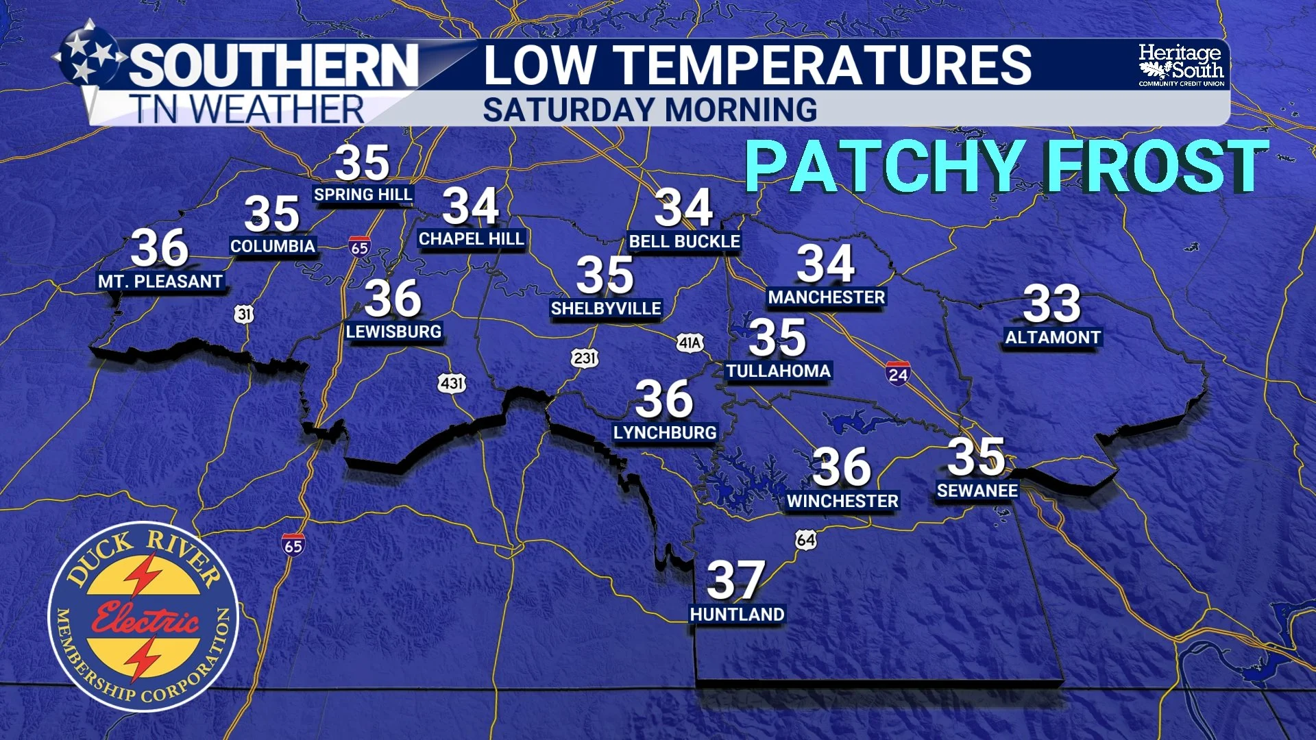
Once the front passes, the air mass changes quickly, but not dramatically. Winds will shift out of the north and increase, with gusts up to around 25 mph. This signals the arrival of a cooler and much drier air mass, driven by high pressure building in from the north. By Saturday morning, some locations( especially across northern Middle Tennessee and the higher elevations of the Plateau) could dip into the lower 30s, flirting with a light freeze. Light frost will be possible across the entire area though. Make sure to prepare sensitive vegetation…
What’s interesting here is how shallow this cooler air mass is. It’s not a deep, long-lasting cold pattern. Instead, it’s more of a quick intrusion of cooler air, typical of late-season fronts.
A Dry Air Mass Takes Over
Behind the front, the bigger story becomes the dryness of the air mass. Relative humidity values are expected to drop significantly over the weekend, in some cases down into the mid 20% range during the afternoon.
This happens because the incoming air originates from a continental source region, meaning it has very little moisture content. With clear skies and full sun, that dry air mixes down efficiently during the day. Even though temperatures will be cooler, the atmosphere will feel noticeably drier — a reminder that temperature and moisture don’t always move together.
The Pattern Reloads Next Week
The cooldown this weekend doesn’t last long. By Sunday, winds begin to turn back out of the south as high pressure shifts east. This re-establishes return flow, allowing warmer and slightly more humid air to move back into the region.
At the same time, the upper-level ridge redevelops and shifts eastward, anchoring itself near the Southeast. That combination leads to another warming trend, with temperatures likely returning to the 80s by Tuesday and Wednesday … and once again approaching record levels.
Looking Ahead
Beyond midweek next week, there are early signals that the pattern could become more active again. However, there’s still a good amount of uncertainty in how that evolves, particularly with the timing and strength of the next system.
The Bottom Line 🧾
• Very warm today with highs in the 80s and record highs possible
• A weak cold front brings light showers Friday afternoon
• Rainfall will be limited, generally under a tenth of an inch
• Cooler and drier air arrives Saturday, with some areas near freezing by morning
• Dry weather continues through the weekend
• Temperatures climb back into the 80s early next week
📰 Reminder: The Southern Tennessee Weather Blog, presented by Heritage South Community Credit Union, is updated Monday through Friday with fresh, locally tailored forecasts you can trust.