
Two Storm Threats to Watch Over the Next 5 Days

The Southern Tennessee Weather Blog is proudly presented by Heritage South Community Credit Union.
We Help When Others Won’t!
Visit https://www.heritagesouth.org/ today to see how HSCCU can help YOU!
The recent stretch of warm, dry, and comfortable weather across Southern Middle Tennessee has been driven by a ridge of high pressure. In simple terms, that means air is sinking from above. Sinking air warms and dries out as it moves downward, which prevents clouds and rain from forming. That’s why we’ve had so many sunny days in a row. The downside is that this same pattern has allowed drought conditions to worsen. Now, that setup is beginning to change…
Over the next several days, the overall weather pattern across the country becomes more “zonal,” meaning winds in the upper atmosphere shift to more of a west-to-east flow. When that happens, storm systems can move more freely into our area. At the same time, surface winds turn out of the south, pulling moisture north from the Gulf. That combination of increasing moisture and incoming disturbances is what leads to a more active pattern. Within that shift, there are two storm systems worth watching.
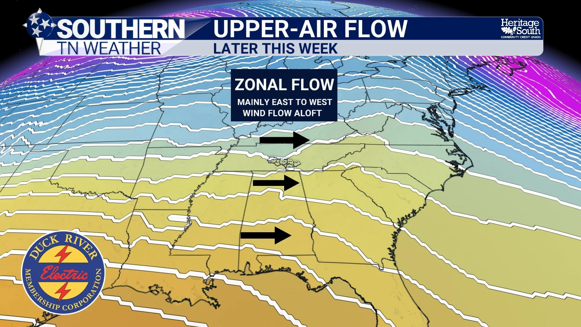
UPPER-AIR PATTERN - LATE THIS WEEK
FRIDAY NIGHT INTO SATURDAY MORNING: LIMITED BUT NOT ZERO
The first round arrives late Friday into early Saturday. This setup depends heavily on storms developing to our west and then moving into Middle Tennessee. That’s what meteorologists call “upstream convection,” meaning storms that form somewhere else and then travel into our area. As these storms approach Southern Middle Tennessee, they will be moving into an environment that is not particularly supportive of strong storms.
One of the key ingredients we look at is instability, which is essentially how much energy the atmosphere has available for storms. This is often measured using something called CAPE. Higher CAPE values mean stronger updrafts and more intense storms. In this case, CAPE values look fairly low, which limits storm strength. Another important factor is lapse rates, which describe how quickly temperature decreases with height. Steeper lapse rates allow air to rise more quickly, helping storms grow stronger. Right now, those lapse rates are not very impressive. Finally, wind shear is also on the weaker side. Wind shear refers to how much the wind changes in speed or direction with height. Strong shear helps storms organize and last longer. Without it, storms tend to be more scattered and short-lived.
On top of all that, timing works against us. These storms arrive at night, and storms rely on daytime heating to build energy. Without that heating, they tend to weaken. So what does all of this mean? Most of Southern Middle Tennessee will see scattered showers and thunderstorms, with lightning and brief heavy rain being the main impacts. A few storms could produce gusty winds, especially if a stronger cluster holds together, but overall this is a low-end threat. Also, this type of setup is rarely uniform. Some areas will pick up a quick downpour, while others may see very little rain. The Storm Prediction Center has a MARGINAL risk (level 1/5) for severe weather in place.
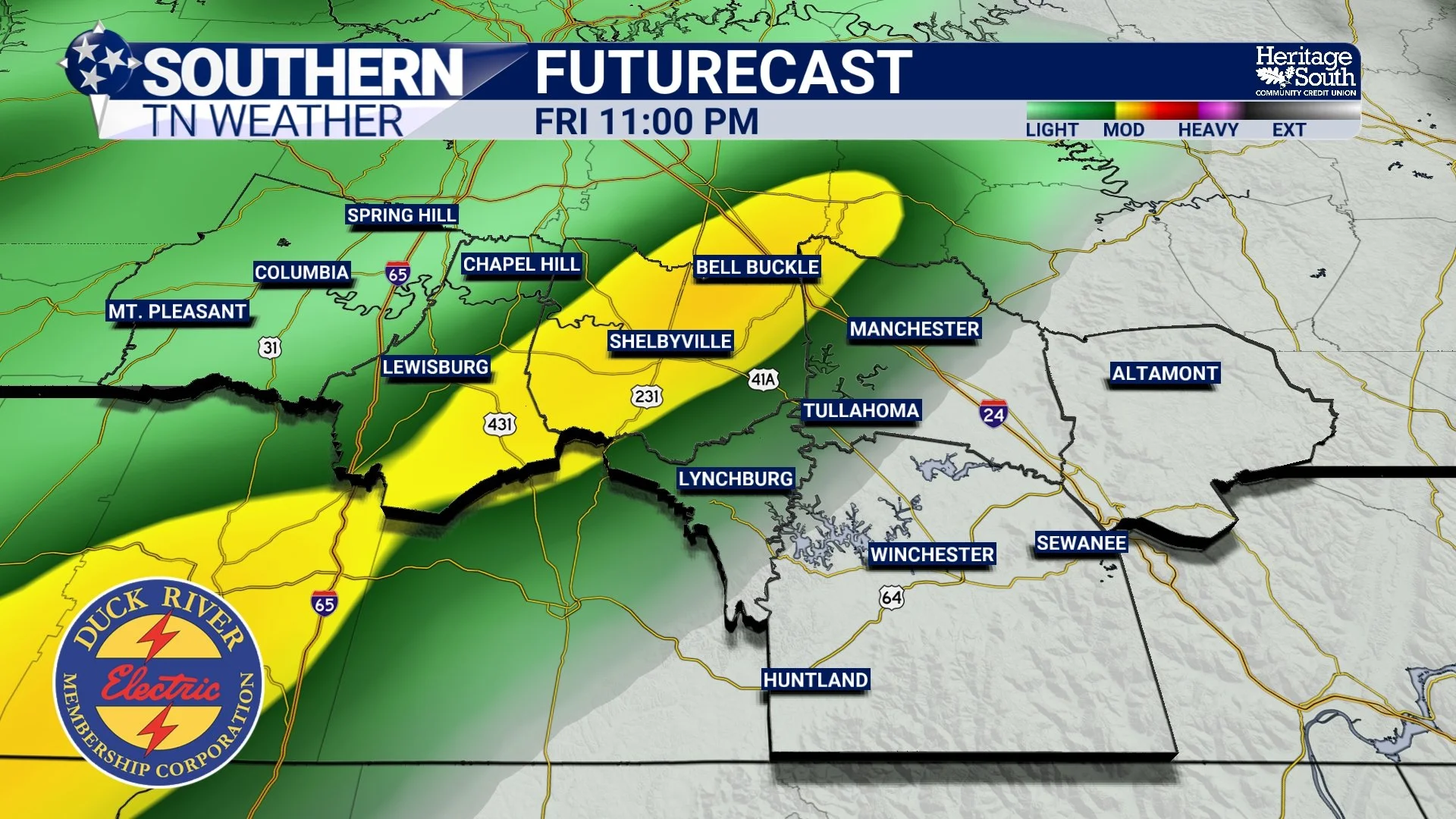
FUTURECAST - FRIDAY NIGHT
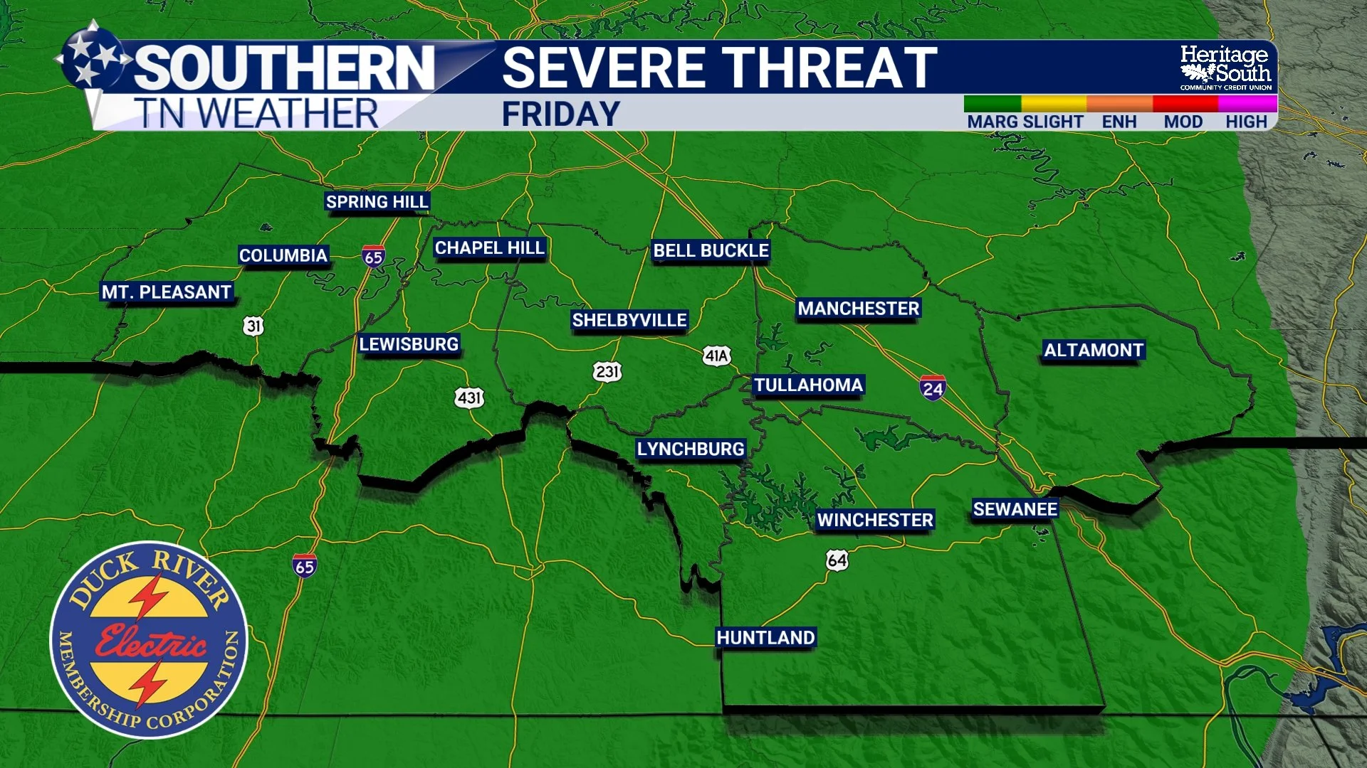
SEVERE WEATHER THREAT - FRIDAY
SATURDAY: MORE RAIN, BUT STILL LIMITED ORGANIZATION
Saturday keeps us in an unsettled pattern, but not necessarily a more dangerous one. We may see additional rounds of showers and storms as smaller disturbances move through the flow. Moisture will be higher compared to Friday, which helps with rain potential, but the atmosphere still lacks the stronger wind dynamics needed for widespread severe weather. In practical terms, that means periods of rain, occasional thunder, and some locally heavier downpours, but storms will likely remain disorganized.
From a drought perspective, this is helpful, but not a complete fix. These systems may provide some beneficial rainfall, but totals will vary quite a bit from one location to another.
MONDAY: A MORE CLASSIC SPRING SETUP
Monday is a different story… A stronger storm system is expected to develop to our west and move toward the Midwest. This system has much better large-scale support, meaning the overall atmosphere is working together in a way that is more favorable for organized storms. Ahead of this system, winds will pull in deeper Gulf moisture, with dew points rising into the 60s. Dew point is a measure of how much moisture is in the air, and higher values mean a more humid and storm-friendly environment.
At the same time, daytime heating will help build instability, with CAPE values potentially reaching 1500 to 2000 J/kg. That’s enough energy to support strong storms. Wind shear also increases into the 35 to 40 knot range. That’s important because it helps storms rotate and maintain structure. When storms can stay organized, they are more capable of producing severe weather. Another factor is lapse rates, which are expected to improve into a range that supports stronger updrafts. This increases the potential for hail and enhances overall storm intensity.
Putting all of this together, Monday has the potential to support all types of severe weather, including damaging winds, large hail, and possibly tornadoes, especially across areas along and west of I-65. HOWEVER, there are still uncertainties. The exact track of the system, how far north the strongest dynamics stay, and whether earlier storms interfere with the setup will all influence the final outcome. At this point, it is something to monitor closely, not something to overreact to. Monday, a level 2/5 SLIGHT risk is in place from the Storm Prediction Center for areas along and west of Interstate 65.
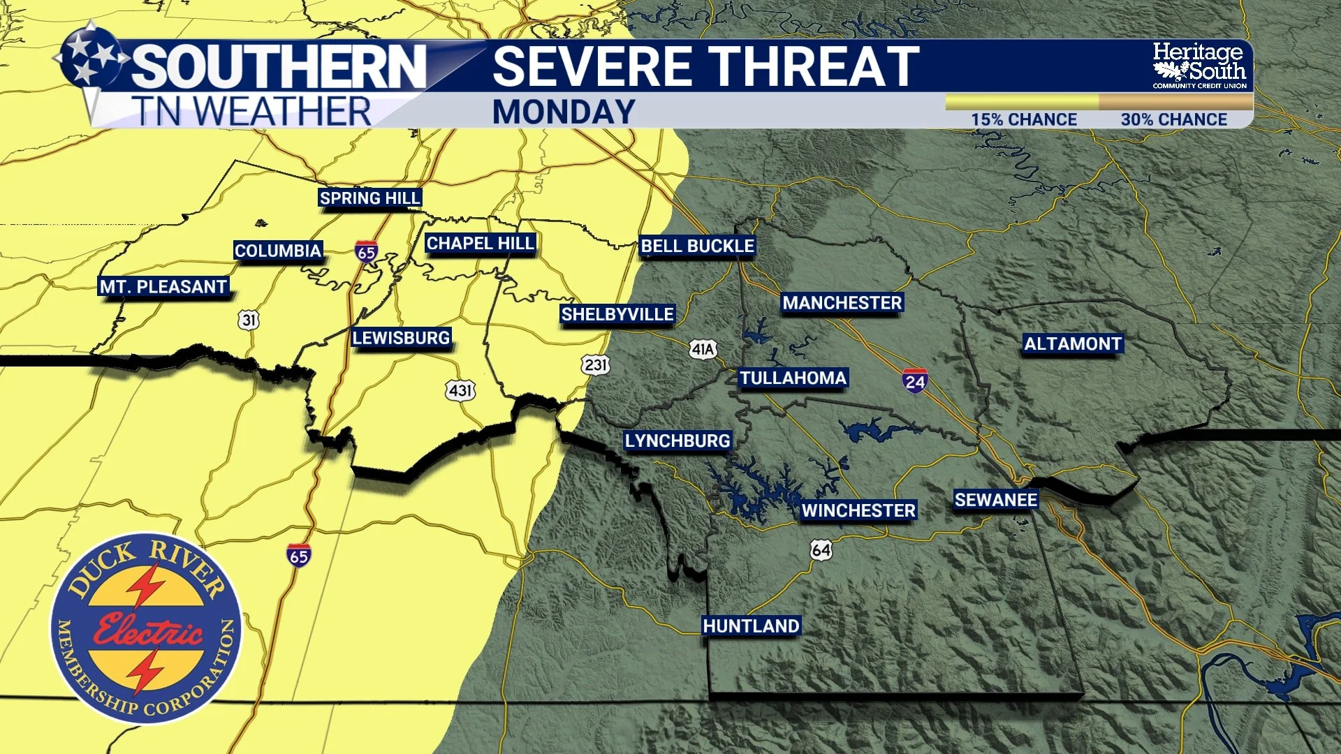
SEVERE THREAT - MONDAY
THE BIGGER PICTURE
We are moving from a quiet, stable setup into a more typical late-April pattern where the atmosphere becomes more active. That means increasing humidity, more frequent rain chances, and occasional opportunities for stronger storms. It also means we finally have a chance to chip away at the drought, even if it happens gradually rather than all at once!
The Bottom Line 🧾
Dry and warm conditions continue through Thursday
Storms arrive late Friday into early Saturday with limited severe potential
Additional showers and storms possible Saturday with modest rainfall
Monday presents a more favorable setup for severe weather
Overall pattern transitioning to a more active spring regime
📰 Reminder: The Southern Tennessee Weather Blog, presented by Heritage South Community Credit Union, is updated Monday through Friday with fresh, locally tailored forecasts you can trust.