
A Strong Cold Front Is Coming... But Where's the Rain?

The Southern Tennessee Weather Blog is proudly presented by Heritage South Community Credit Union.
We Help When Others Won’t!
Visit https://www.heritagesouth.org/ today to see how HSCCU can help YOU!
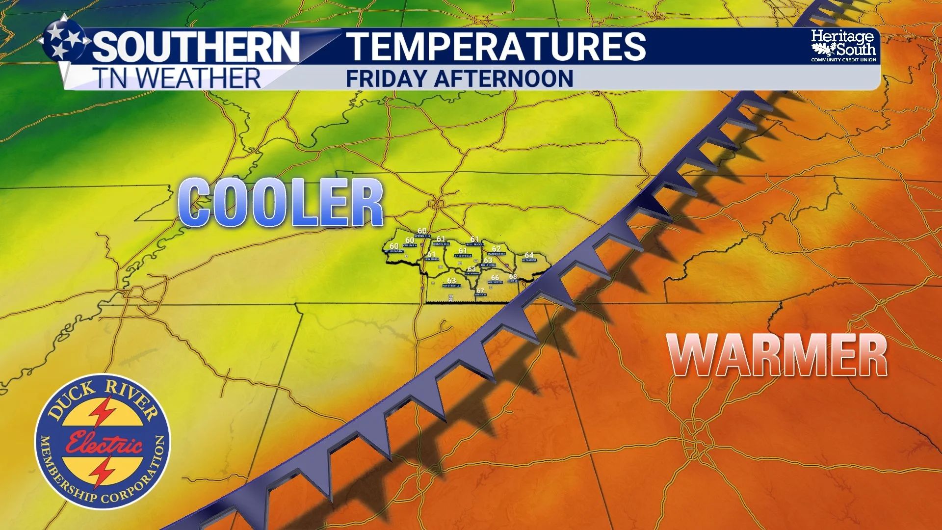
We've got a pretty significant change in our weather headed toward Southern Middle Tennessee later this week, and I think most of us are going to appreciate it after several days of temperatures that have felt more like the middle of August than the middle of October. A strong cold front is expected to sweep through the region Friday, bringing gusty northerly winds and a MUCH cooler air mass just in time for the weekend. We're talking about going from afternoon highs approaching 90 degrees to temperatures struggling to climb out of the 60s by Saturday, with some locations potentially experiencing their first temperatures in the 30s by Sunday morning.
That sounds like a pretty impressive cold front, doesn't it? And it is! However, there's one rather important ingredient missing from this forecast, especially considering our ongoing drought: RAIN.
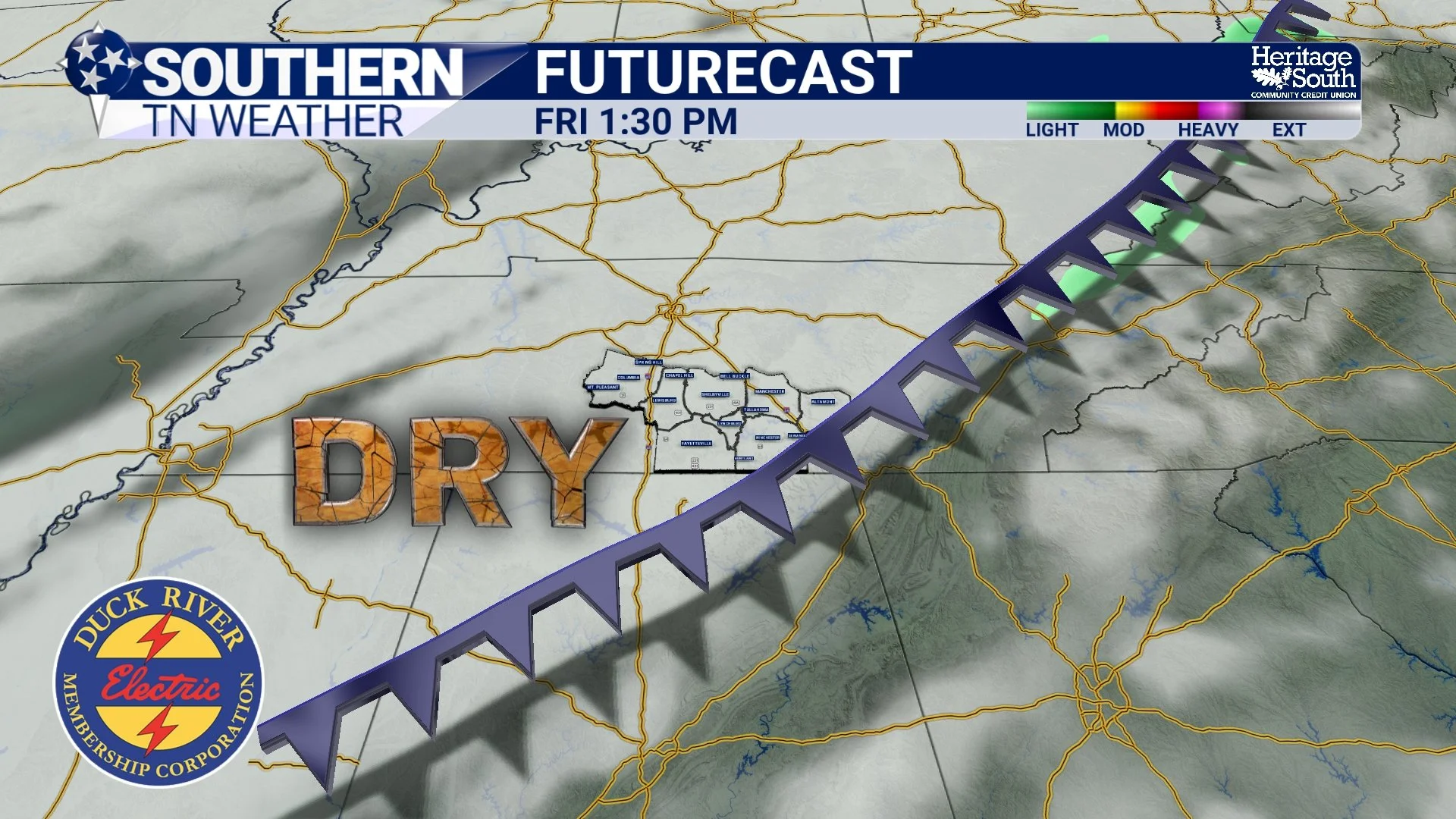
Despite the strength of Friday's cold front, we're not expecting much, if any, meaningful rainfall as it moves through Southern Middle Tennessee. In fact, the latest forecast guidance suggests the frontal passage could be almost completely dry. That's certainly not what we'd prefer after dealing with weeks of significant rainfall deficits, but it's also a perfect opportunity to answer a question that comes up quite frequently: How can a cold front be strong enough to drop our temperatures by 20 degrees or more, yet fail to produce a single drop of rain?
The answer involves several different atmospheric ingredients, and it turns out that a strong cold front doesn't necessarily mean we're going to experience strong thunderstorms, or even ordinary rain showers. Let's talk about why.
A Cold Front Doesn't Actually Produce Rain by Itself
One of the biggest misconceptions about cold fronts is that they automatically produce rainfall. After all, when we watch weather forecasts on television or look at weather maps, cold fronts are frequently associated with clouds, showers and thunderstorms. It makes sense that people would assume the arrival of a strong front means rain is on the way.
However, a cold front is simply the leading edge of an advancing colder air mass. It marks the boundary between air masses with different temperatures and densities, and its primary job, so to speak, is to replace the warmer air already in place with cooler air moving into the region. Because colder air is generally denser than warmer air, it tends to wedge underneath the warmer air ahead of the front. That process can force the warmer air upward, which is one of the important ingredients needed for cloud and precipitation development. But here's the catch: lifting air doesn't automatically produce rainfall.
For precipitation to develop, the atmosphere needs sufficient moisture. As air rises, it expands and cools, and if enough moisture is present, water vapor can condense into cloud droplets. With continued lifting and favorable cloud conditions, those droplets or ice particles can grow large enough to fall as precipitation. If the atmosphere is too dry, however, that same lifting process might produce little more than a few clouds. In some cases, clouds may not develop at all. Even if precipitation forms several thousand feet above the ground, it can evaporate before reaching the surface if the air underneath is particularly dry. Meteorologists call that phenomenon virga.
So, a cold front can bring a dramatic temperature change, a noticeable wind shift and rising atmospheric pressure without producing any measurable rainfall. The strength of the incoming cold air and the amount of moisture available are two different parts of the forecast. And this Friday, those two ingredients simply aren't lining up very well.
Moisture Is the Missing Ingredient This Time Around
To understand why Friday's cold front is expected to be relatively dry, we need to look at the larger weather pattern developing across the United States. A strong upper-level disturbance is forecast to move through the Great Lakes and Ohio Valley region, helping drive a cold front southward through Southern Middle Tennessee. However, the primary area of low pressure and strongest upper-level forcing will remain well to our north and northeast. That's an important distinction because the most favorable ingredients for widespread precipitation won't necessarily be located along the portion of the front moving through our area. While the front will have plenty of colder air behind it, the deeper atmospheric moisture needed to support widespread showers and thunderstorms is expected to be limited.
We’re noting that a separation between the main low-pressure system farther north and east and the drier air moving in from the west will favor a dry frontal passage. Meanwhile, the Nashville forecast continues to indicate that Friday's cold front will arrive with very little meaningful rainfall. In other words, the front is going to be quite effective at changing our temperatures, but not particularly effective at producing precipitation.
There's also another important factor worth discussing: the timing of our available moisture. A separate disturbance and moisture axis will be positioned farther north across the Ohio Valley on Wednesday, bringing opportunities for showers and thunderstorms primarily along and north of Interstate 40. By the time Friday's stronger cold front reaches Southern Middle Tennessee, that better moisture will no longer be positioned to interact with it. That's why we can have rain chances associated with one disturbance on Wednesday, followed by a stronger cold front on Friday that produces little or no rainfall. The atmosphere is essentially delivering the ingredients at different times instead of bringing them together in the same place.
Why Can Some Cold Fronts Produce Severe Thunderstorms While Others Stay Dry?
This is where the science gets particularly interesting. If a cold front doesn't automatically produce rain, what determines whether we experience widespread thunderstorms, a few scattered showers or absolutely nothing? Meteorologists often focus on three basic ingredients when forecasting thunderstorm development: moisture, instability and lift. Each plays a different role, and the absence of even one can significantly limit the potential for storms.
Moisture provides the water vapor needed for cloud and precipitation development. Instability determines how readily parcels of air can continue rising once they're lifted, while lift provides the initial upward motion needed to get the process started. A cold front can provide that lifting mechanism, but if the air is too dry or stable, widespread thunderstorms may never develop. For organized severe thunderstorms, additional factors such as vertical wind shear become important. Wind shear describes changes in wind speed or direction with height, and it can help storms become stronger and more organized when the other ingredients are favorable. During spring, for example, Southern Middle Tennessee frequently experiences weather systems that combine strong cold fronts, abundant Gulf moisture, considerable instability and powerful upper-level winds. When those ingredients overlap, the result can be widespread thunderstorms, sometimes including severe weather.
However, that same type of frontal boundary moving through a much drier atmosphere might produce little more than a wind shift and falling temperatures. Think of it like trying to bake a cake. You might have a perfectly good oven and plenty of heat, but if you're missing several important ingredients, you're not going to end up with much of a cake. In our case, Friday's front has plenty of colder air available, but the moisture and other ingredients needed for widespread rainfall simply aren't expected to come together.
A Strong Temperature Drop Doesn't Require Strong Thunderstorms
Another common misconception is that the more dramatic the temperature change, the stronger the thunderstorms must be. While powerful cold fronts can certainly be associated with severe weather, the temperature difference between two air masses doesn't automatically determine how much rain or thunderstorm activity will develop. The temperature drop associated with a front depends heavily on the characteristics of the incoming air mass. If a cold front is transporting air that originated much farther north, temperatures can fall substantially regardless of whether clouds or precipitation develop.
That's exactly what we're expecting this week. An upper-level ridge has been responsible for our unusually warm weather, allowing afternoon temperatures to climb into the upper 80s and lower 90s across portions of the region. Once that ridge begins shifting away and the approaching trough helps drive the cold front southward, our prevailing winds will shift from the southwest toward the north and northwest. That wind shift will allow much cooler air to spread into Southern Middle Tennessee, with temperatures dropping considerably Friday afternoon and especially Friday night. In fact, the National Weather Service in Huntsville expects temperatures to fall into the lower and middle 60s by Friday evening, with overnight lows dropping into the 40s across much of the area by Saturday morning.
By Saturday afternoon, many communities may struggle to climb beyond the middle and upper 60s. That's a dramatic change compared to the near-90-degree temperatures we're experiencing right now, and it doesn't require a single thunderstorm to make it happen. There's also a good chance Friday will be rather breezy. Winds are expected to turn north-northwesterly behind the front, with sustained speeds around 15 to 25 MPH possible in portions of the region. Those winds will help transport the cooler air southward and make the temperature change feel even more noticeable. So, even though the radar may look relatively quiet Friday, the atmosphere will still be undergoing a substantial transition.
What Does This Mean for Our Ongoing Drought?
Unfortunately, the lack of meaningful rainfall with Friday's cold front isn't particularly encouraging when we consider the drought conditions across Southern Middle Tennessee. As we've discussed in recent drought updates, much of our region continues to experience Moderate to Severe Drought, with Extreme Drought affecting portions of the upper Duck River Basin. The prolonged stretch of hot, dry weather during September created substantial moisture deficits, and while last weekend's rainfall associated with Hurricane Isaias provided some beneficial moisture, it wasn't necessarily enough to eliminate those longer-term shortages. A strong cold front bringing cooler temperatures is certainly welcome, especially after several days of record-challenging heat. Cooler conditions can help reduce the atmosphere's demand for moisture, and lower temperatures generally slow evaporation compared to similarly sunny, hotter conditions. However, cooler weather doesn't actually replace the rainfall we're missing.
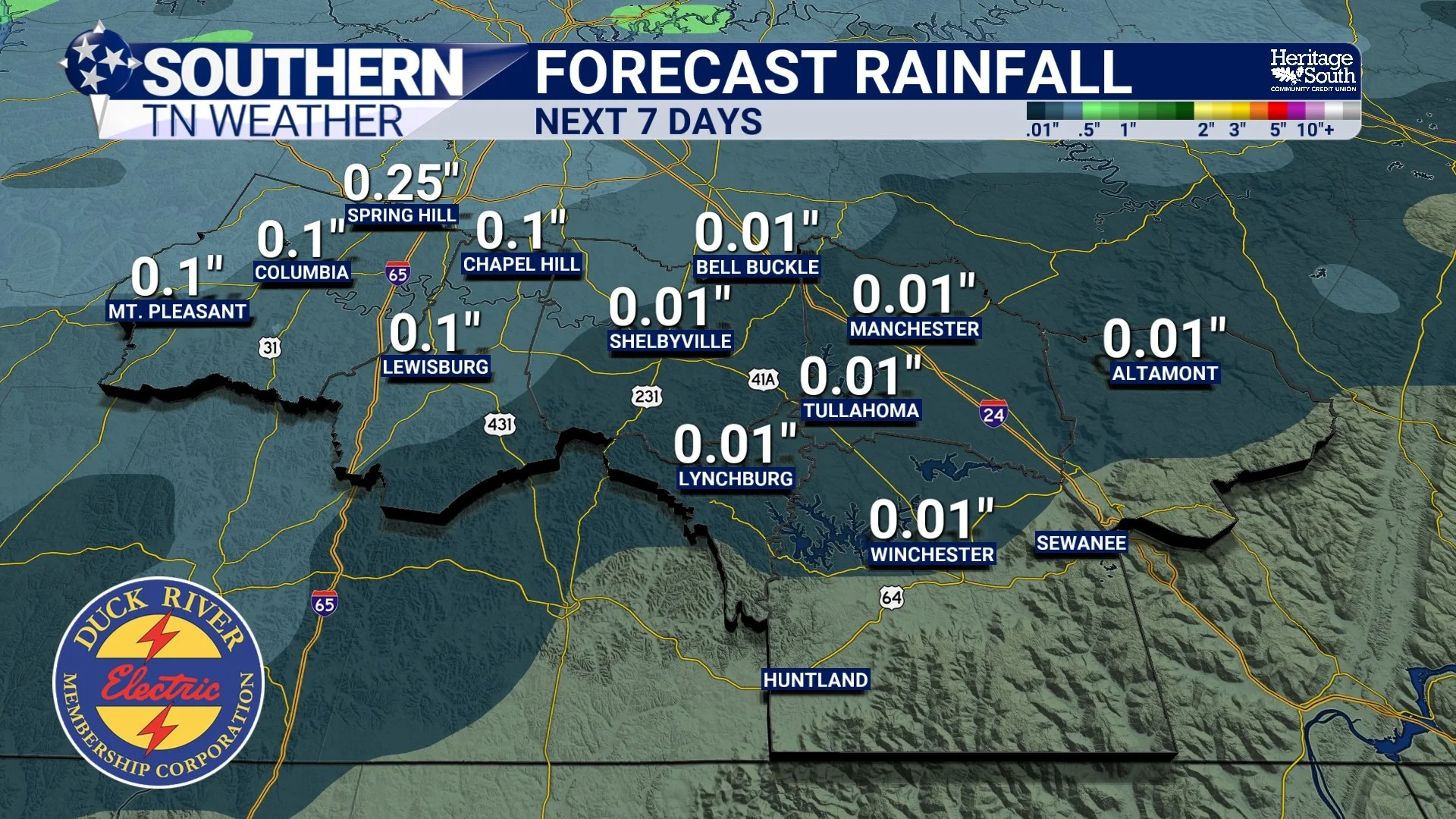
That's the frustrating part of this particular forecast. We're finally getting a substantial change in our temperatures, but we're not expecting the widespread, soaking rainfall that would help replenish soil moisture, streams and agricultural water supplies. Today's rain chances aren't looking especially promising for most of our coverage area, either. The better opportunities for showers and thunderstorms will remain primarily along and north of Interstate 40, where the National Weather Service in Nashville indicates a 50–70% chance of receiving at least one-tenth of an inch of rainfall. Farther south, across most of Southern Middle Tennessee, the influence of upper-level high pressure should keep conditions predominantly dry.
After Friday's front moves through, another stretch of dry weather appears likely through the weekend and into early next week. While the cooler air will be a welcome change, we're going to need additional rainfall events before we can begin talking about a more substantial recovery from our ongoing drought. And unfortunately, the current forecast isn't offering much in that department.
This Week's Forecast: Record Heat, Then a Sharp Cooldown
Now that we've covered why Friday's cold front isn't expected to produce much rainfall, let's take a closer look at how the weather will unfold across Southern Middle Tennessee over the next several days.
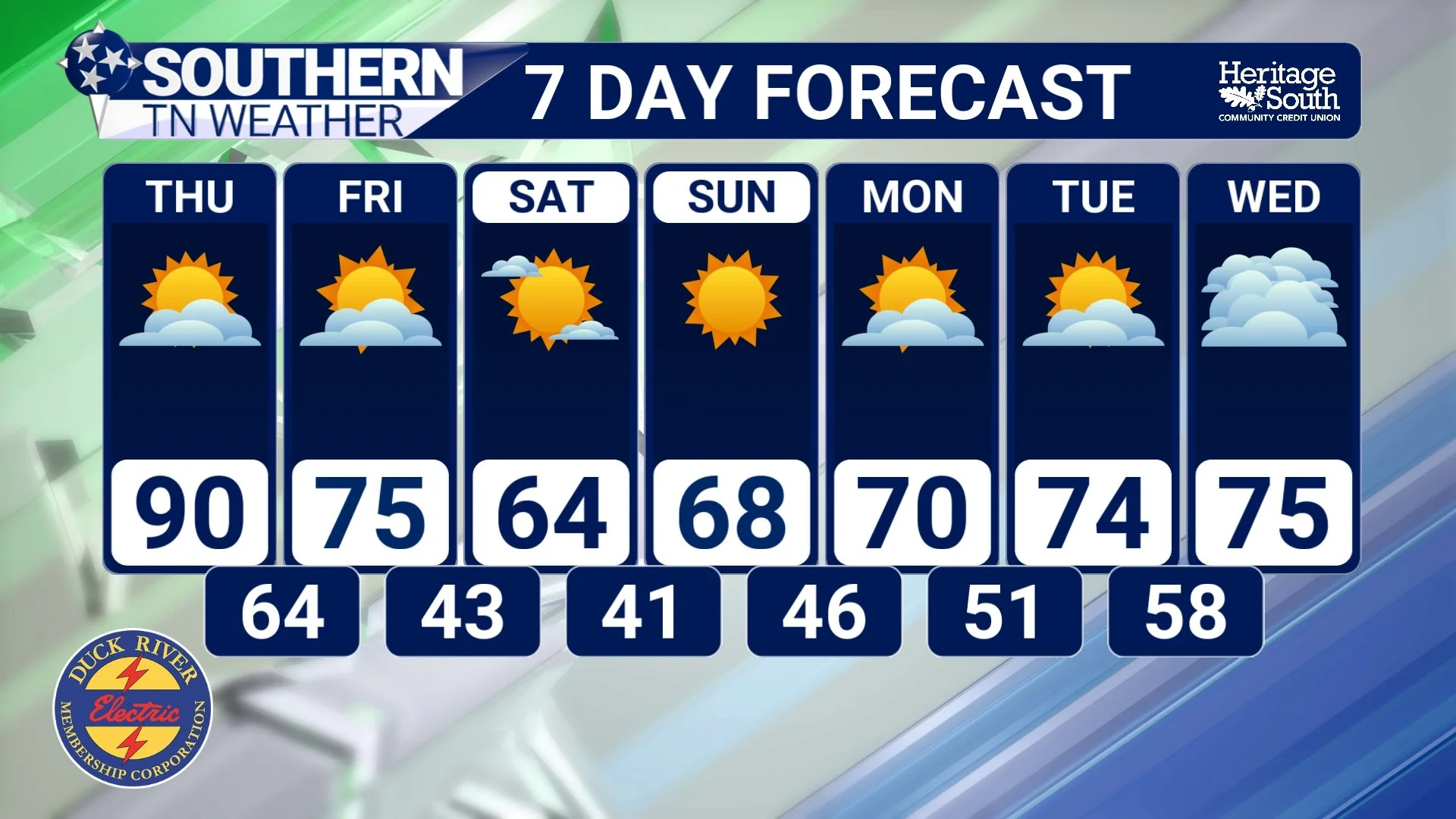
Wednesday: We're expecting another unusually warm day, with high temperatures climbing into the middle and upper 80s and some locations potentially reaching the lower 90s. That's roughly 15 degrees warmer than normal for the middle of October, and daily record highs could be challenged or broken in portions of Middle Tennessee. Humidity will also be noticeable, with dew points climbing into the 60s. An atmospheric disturbance passing to our north will bring increasing clouds and a chance of showers and thunderstorms during the afternoon and evening, but the best opportunities for rainfall will remain along and north of Interstate 40. Most of Southern Middle Tennessee should remain dry.
Thursday: One more very warm day is expected before our weather pattern begins changing. Afternoon highs will generally reach the upper 80s to around 90 degrees, with some communities once again flirting with record highs. Skies should remain mostly sunny to partly cloudy, and widespread rainfall is not expected. Overnight temperatures will remain relatively mild ahead of the approaching cold front, generally falling into the lower and middle 60s.
Friday: Our strong cold front will move through Southern Middle Tennessee, likely during the morning hours, although some timing differences remain possible. Temperatures may reach the 70s to around 80 degrees before the cooler air becomes firmly established, but conditions will change noticeably throughout the day. Winds will shift toward the north and northwest and become rather gusty, with some locations experiencing sustained winds of 15 to 25 MPH. Temperatures should fall considerably by Friday evening, potentially reaching the lower and middle 60s around sunset. Unfortunately, the front currently looks predominantly dry.
Saturday: A much cooler air mass will be firmly established across the region, bringing our first real taste of autumn in quite some time. Morning lows will generally fall into the middle and upper 40s, while afternoon highs should only reach the middle and upper 60s. Breezy northerly winds may continue for part of the day, making conditions feel even cooler, especially during the morning hours.
Sunday: The cooler weather will continue, with afternoon highs generally in the upper 60s to lower 70s. Overnight temperatures could fall into the upper 30s and 40s, with the coldest readings favored across the Cumberland Plateau and our typically colder valleys. Some frost will be possible. Widespread frost or freezing temperatures aren't guaranteed, but it's certainly something worth keeping an eye on as we get closer.
Early Next Week: Unfortunately for those hoping fall weather is finally here to stay, another upper-level ridge is expected to develop across the Southeast. This should allow temperatures to gradually warm back into the middle and upper 70s by Monday and Tuesday, with continued dry conditions across much of the region.
The Bottom Line 🧾
🌬️ A strong cold front is expected Friday, bringing a substantial cooldown to Southern Middle Tennessee.
🌧️ Cold fronts do NOT automatically produce rainfall. They need sufficient moisture and favorable atmospheric conditions to generate showers and thunderstorms.
💨 Friday's front will have plenty of colder air behind it, but the deeper moisture needed for widespread rainfall is expected to be limited.
⛈️ Showers and thunderstorms require moisture, instability and lift. Organized severe storms also depend on factors such as vertical wind shear.
🔥 High temperatures will remain in the upper 80s and lower 90s through Thursday, with additional record highs possible.
🌦️ Rain and storm chances increase Wednesday afternoon and evening, primarily along and north of Interstate 40. Most of Southern Middle Tennessee should remain dry.
🍂 Friday's cold front will bring gusty northerly winds and falling temperatures, with little meaningful rainfall expected.
🥶 Saturday's highs will generally only reach the middle and upper 60s, a dramatic change compared to the near-90-degree warmth earlier in the week.
❄️ Overnight temperatures could fall into the upper 30s and 40s by Sunday morning, with a potential frost concern across portions of the Cumberland Plateau.
🌵 Unfortunately, the lack of rainfall means our ongoing drought will remain a concern despite the cooler temperatures.
☀️ Another warming trend is expected early next week as upper-level high pressure returns to the Southeast.
📰 Reminder: The Southern Tennessee Weather Blog, presented by Heritage South Community Credit Union, is updated Monday through Friday with fresh, locally tailored forecasts you can trust.
