
Frost vs. Freeze: What's the Difference, and When Should We Start Paying Attention?

The Southern Tennessee Weather Blog is proudly presented by Heritage South Community Credit Union.
We Help When Others Won’t!
Visit https://www.heritagesouth.org/ today to see how HSCCU can help YOU!
It's the middle of October, temperatures are approaching 90 degrees across portions of Southern Middle Tennessee, and we're still talking about the possibility of breaking daily record highs. Not exactly the kind of weather that makes you want to dig out the winter coat, is it? However, if there's one thing we've learned about October weather around here, it's that conditions can change in a hurry. After several afternoons of summerlike warmth, a strong cold front is expected to move through our region Friday, bringing a much cooler air mass just in time for the weekend.
While the latest forecast doesn't necessarily point toward a widespread frost or freeze event this weekend, we're quickly approaching the time of year when those possibilities become increasingly important. Overnight temperatures will be falling back into the 40s behind Friday's cold front, and as we move deeper into October, it won't be long before some of our colder valleys and sheltered communities begin flirting with the 30s more regularly.
That brings up a question I hear just about every fall: What's the difference between frost and a freeze, and why does it matter? After all, both involve cold temperatures, both can damage sensitive plants, and both tend to send gardeners scrambling to cover whatever is still growing outside. However, there's actually some pretty interesting meteorology behind the distinction, and understanding it can help you make better decisions as our first genuinely cold mornings approach.
STNWX TITLE PAGE
Frost and Freezes Aren't Actually the Same Thing
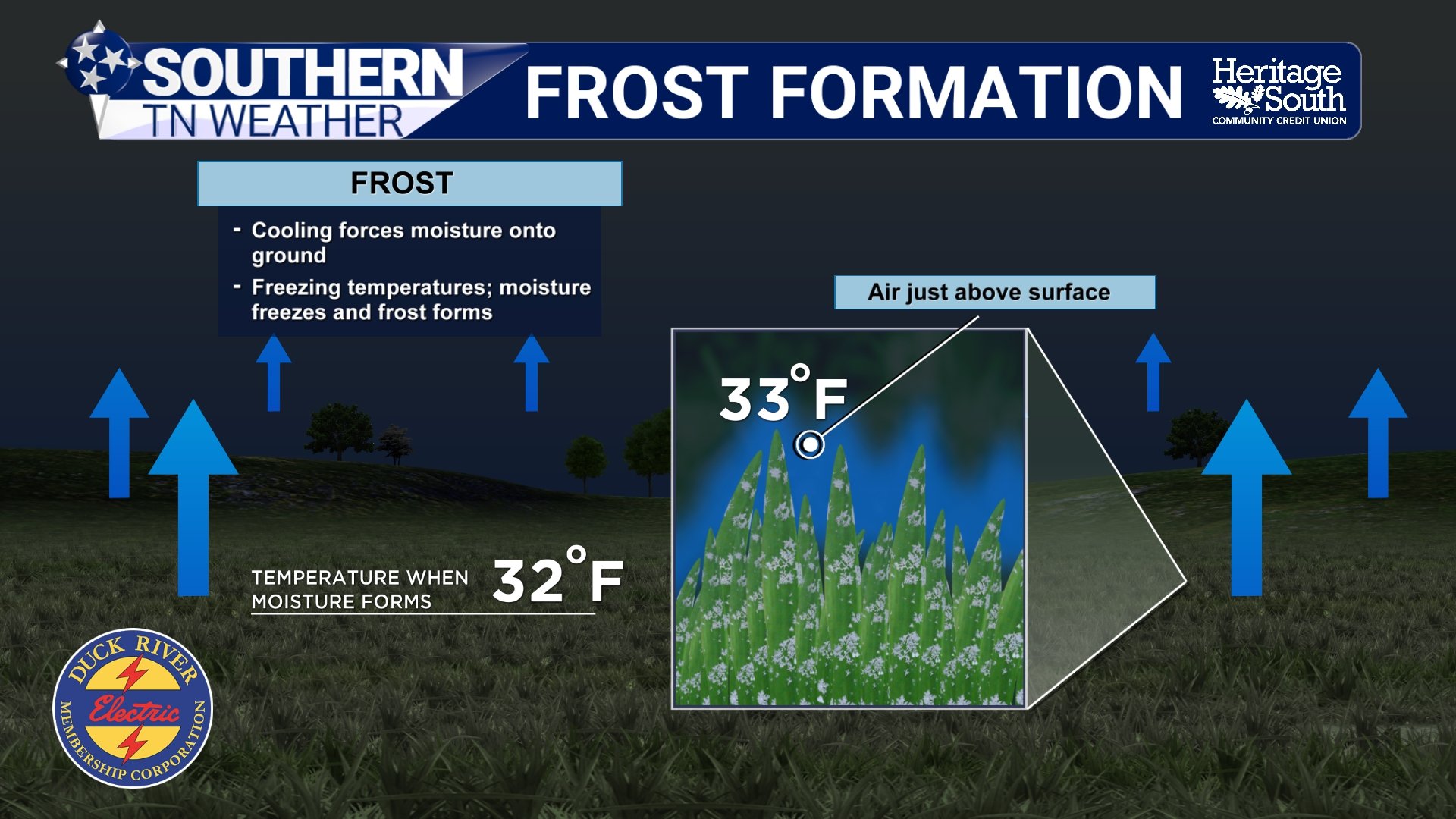
Let's start with frost, because it's probably the term most people are familiar with. Frost is the thin layer of ice crystals that can form on exposed surfaces such as grass, leaves, vehicles and rooftops when those surfaces become cold enough. Under the right conditions, water vapor in the surrounding air deposits directly onto a surface as ice, creating the familiar white coating we often see on chilly autumn mornings. Here's where things get interesting: frost can develop even when the official air temperature never reaches 32 degrees.
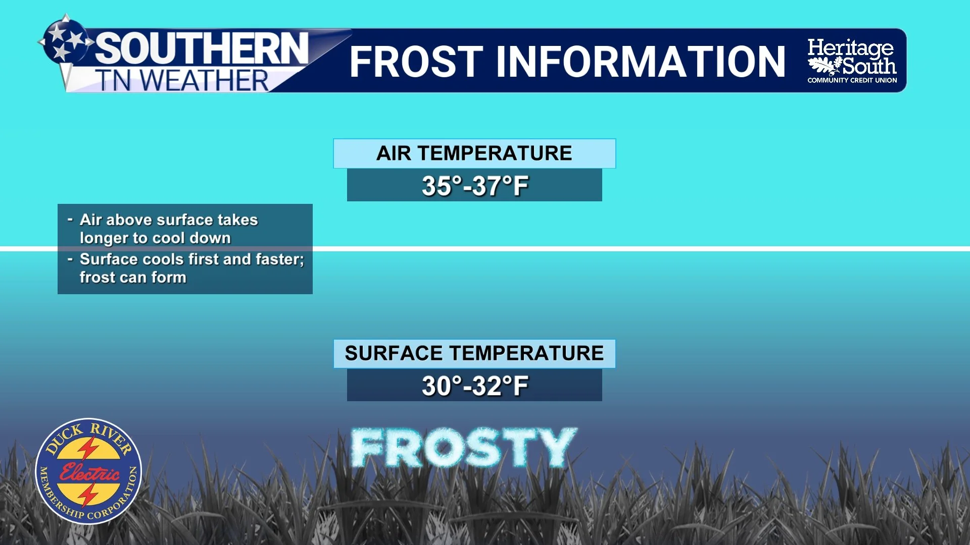
That's because the temperatures you see in a weather forecast are generally measured approximately five feet above the ground, while the surfaces where frost forms can become considerably colder. On a clear, calm night, grass and other exposed objects lose heat through infrared radiation, sometimes cooling several degrees below the surrounding air. That means a thermometer at the official observation height might read 35 or 36 degrees while the grass itself has cooled to freezing or below.
This is why meteorologists begin paying attention to frost potential when forecast lows approach the middle 30s, particularly in sheltered valleys and low-lying areas. However, temperature alone doesn't determine whether frost forms. There also needs to be sufficient moisture in the air near those surfaces, and conditions generally favor frost development when skies are clear and winds are light.
A freeze, on the other hand, refers to the air temperature itself reaching 32 degrees or lower at the standard observation height. Unlike frost, which describes ice forming on surfaces, a freeze describes the temperature of the surrounding air. A freeze can occur with or without visible frost. If the air is extremely dry, temperatures can fall below freezing without producing that familiar white coating on the grass. Likewise, if winds remain strong, the atmosphere may stay sufficiently mixed to limit frost formation on exposed surfaces, even when the air temperature reaches freezing. So, while frost and freezing temperatures frequently occur together, they aren't interchangeable terms.
Why Can Frost Form When It's 36 Degrees Outside?
To understand why frost can develop above freezing, we need to talk about something called radiational cooling. Don't worry, it's not nearly as complicated as it sounds. Throughout the day, sunlight warms the Earth's surface. That surface then transfers heat into the air immediately above it, helping temperatures rise during the afternoon. Once the sun sets, the ground begins losing energy by emitting infrared radiation. Without incoming sunlight to replace that energy, the surface gradually cools, and the air closest to the ground often follows. On clear nights, that energy can escape more efficiently because there are fewer clouds to absorb and reemit infrared radiation back toward the surface. Light winds also allow the coldest air to remain concentrated near the ground instead of mixing with warmer air above it.
Under these conditions, the temperature of exposed surfaces can fall below the temperature measured several feet above the ground. That's particularly important for grass, garden plants and other vegetation because their leaves can cool to freezing even when the official air temperature remains a few degrees warmer. Humidity also plays a role. If the air near the surface contains enough moisture and the surface temperature falls below freezing, ice crystals may begin forming. However, if the air is too dry, you might experience freezing surface temperatures without seeing much visible frost. This is why a forecast low of 35 degrees doesn't automatically guarantee frost, but it certainly doesn't eliminate the possibility either. Meteorologists have to consider the entire nighttime environment, including wind speeds, cloud cover, dew points and local terrain. And here in Southern Middle Tennessee, that last factor can make a pretty substantial difference.
FROST INFORMATION
Why Some Communities Get Frost Before Others
If you've ever noticed that one community wakes up with frost-covered grass while another location just a few miles away doesn't, there's a good reason for that. Our terrain plays a significant role in how temperatures behave overnight, especially during the fall. Cold air is denser than warm air, and under clear, calm conditions, it tends to drain downhill and collect in valleys, hollows and other low-lying areas. Meteorologists refer to this process as cold-air drainage, and the resulting accumulation of colder air is known as cold-air pooling.
Across Southern Middle Tennessee, we have plenty of locations where this can occur. Sheltered valleys around Lynchburg, low-lying portions of Bedford and Marshall counties, and hollows along the Cumberland Plateau can all experience colder overnight temperatures than nearby elevated locations. For example, a weather station on an exposed hilltop might report a temperature of 41 degrees while a sheltered valley only a short distance away falls to 35 degrees. Both observations can be completely accurate because the local environment is influencing how efficiently the air cools. The Cumberland Plateau adds another interesting wrinkle. Higher elevations are generally cooler than surrounding lower elevations during the day, but nighttime temperature patterns can become more complicated. A sheltered valley below the Plateau may actually become colder than an exposed ridge because cold air settles into the lower terrain while winds keep the air mixed along the higher elevations.
This is one reason why the first frost of the season rarely occurs across our entire coverage area on the same morning. Some communities may experience frost several days or even weeks before others, depending on their elevation, terrain and local weather conditions. It's also why I encourage folks to pay attention to their own backyard conditions rather than relying exclusively on a single forecast temperature for an entire county.
FROST FORMATION
What About a Hard Freeze?
Now that we've covered frost and ordinary freezes, there's another term you'll frequently hear as we move toward November: hard freeze. A hard freeze generally refers to temperatures falling to approximately 28 degrees or lower for a sufficiently long period. Unlike a brief dip to 31 or 32 degrees, which may only damage particularly sensitive vegetation, a hard freeze can cause more extensive damage to plants and typically brings an end to the growing season for many crops and garden plants. The duration of the cold is extremely important. A temperature of 29 degrees for fifteen minutes may produce a very different outcome than a temperature of 29 degrees that persists for several hours. Plant species, their stage of growth, how well they've acclimated to colder weather and the amount of protection they receive all influence the severity of potential damage.
For gardeners, the distinction matters because a light frost might only damage the most sensitive leaves, while a prolonged freeze can damage stems and other plant tissues. Tender summer vegetables such as tomatoes, peppers and squash are particularly vulnerable, while some cool-season plants can tolerate considerably colder temperatures. It's also worth mentioning that the term hard freeze isn't defined by one universally applied threshold in every forecast product. The 28-degree benchmark is commonly used, but local National Weather Service offices may consider additional factors when issuing freeze-related alerts. The important thing to remember is that not every frost is a freeze, and not every freeze is severe enough to produce widespread damage.
Frost Advisory vs. Freeze Warning: What's the Difference?
As we get deeper into autumn, you'll probably begin seeing the National Weather Service issue frost and freeze-related alerts. These products are designed to help people protect sensitive vegetation during the growing season, but they serve slightly different purposes. A Frost Advisory is generally issued when conditions are favorable for frost formation that could damage sensitive outdoor plants. Forecast temperatures are often in the middle 30s, although the exact criteria can vary depending on the local forecast office and growing-season considerations. A Freeze Warning is issued when freezing temperatures are expected during the growing season, creating a more substantial threat to sensitive vegetation. This generally involves air temperatures reaching 32 degrees or lower, although local criteria and expected duration can influence the decision.
You may also hear about a Freeze Watch, which highlights the potential for damaging freezing temperatures when confidence or timing doesn't yet support a warning. One important detail is that frost and freeze products are primarily intended to protect agricultural interests and sensitive vegetation. They aren't issued simply because the temperature gets cold. Once the growing season has ended and a widespread killing freeze has occurred, National Weather Service offices typically discontinue these products until the following growing season. That's why you might see a Freeze Warning issued for temperatures near 30 degrees in October but no similar warning when temperatures fall into the 20s during January.
The temperature itself isn't necessarily less dangerous in January. The difference is that most sensitive vegetation has already entered dormancy or been damaged by earlier freezes, so the agricultural purpose of those warnings has largely ended for the season.
When Should We Start Paying Attention in Southern Middle Tennessee?
For our region, October is absolutely the time to begin monitoring overnight temperatures more closely. Our average first frost dates vary considerably depending on location, elevation and local terrain, but many communities across Southern Middle Tennessee typically experience their first frost sometime during October or early November. Some of our colder valleys and higher-elevation communities can experience frost earlier, while more sheltered urban locations and areas near larger bodies of water may hold onto warmer temperatures a little longer.
If you're still growing tender vegetables, maintaining outdoor flowers or trying to protect sensitive landscaping, I'd recommend becoming more attentive whenever forecast overnight lows begin approaching 36 to 38 degrees. That doesn't mean frost is guaranteed at those temperatures, but it provides a reasonable point to start checking the forecast more carefully, particularly if clear skies and light winds are expected. Once forecast lows begin approaching 32 degrees, the concern shifts toward an actual freeze, and protecting vulnerable plants becomes considerably more important.
For those with gardens, lightweight frost cloths or other breathable plant coverings can help retain some warmth around vegetation. Covers generally work best when they extend to the ground and are secured so that warmth from the soil remains trapped around the plants. It's also important to avoid allowing heavy coverings to crush delicate vegetation and to remove or ventilate coverings when temperatures warm during the day.
And remember, your backyard may be several degrees colder than the nearest official weather station. If you live in a particularly cold valley or hollow, a reliable outdoor thermometer can be extremely helpful as we move deeper into fall.
This Week's Forecast: Record Heat First, Then a Taste of Fall
Now, before anybody starts rushing outside to cover their tomatoes, let's talk about what we're actually expecting over the next several days. While our first frost of the season is certainly getting closer from a climatological standpoint, the latest forecast does not currently indicate a widespread frost or freeze event across Southern Middle Tennessee this weekend. In fact, we're going to experience almost the complete opposite through Thursday!
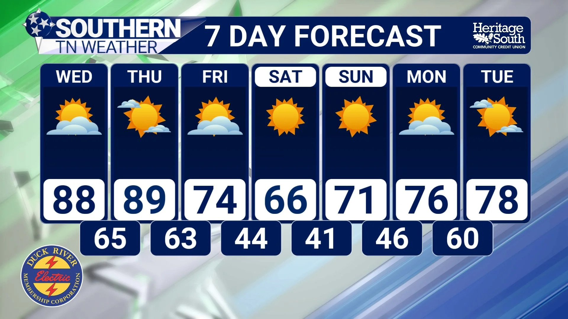
Tuesday through Thursday: A persistent upper-level ridge will continue dominating our weather pattern, allowing temperatures to climb well above normal for the middle of October. Highs will generally reach the middle and upper 80s, with some locations approaching or reaching 90 degrees. That's approximately 15 degrees warmer than normal for this time of year!
Overnight temperatures will remain relatively mild, generally falling into the upper 50s and lower 60s. Most locations will remain dry, although there will be some opportunities for showers and thunderstorms Wednesday afternoon and evening, primarily across areas north of Interstate 40. For our Southern Middle Tennessee coverage area, widespread rainfall is not expected, and most communities should remain dry.
Friday: A strong cold front will move through the region, bringing a noticeable change in our weather pattern. Afternoon temperatures may still reach the upper 70s or lower 80s in some locations, depending on the timing of the front, but breezy conditions and a shift toward northerly or northwesterly winds will signal the arrival of a much cooler air mass. Unfortunately, this front appears likely to move through with little meaningful rainfall, which isn't particularly encouraging given our ongoing drought.
Saturday: Much more seasonable autumn weather will finally return. High temperatures are expected to reach the upper 60s to around 70 degrees across much of Southern Middle Tennessee, a dramatic difference compared to the near-90-degree warmth earlier in the week. Morning temperatures will generally be in the 40s, making jackets a pretty good idea for anyone heading outside early.
Sunday: Another chilly morning is expected, with temperatures generally falling into the 40s. Some of our typically colder valleys could run a few degrees cooler, depending on cloud cover and wind conditions, but widespread freezing temperatures are not currently anticipated. Afternoon highs should recover into the upper 60s and lower 70s, providing some pretty pleasant fall weather.
And here's another interesting twist: this cooler weather may not stick around for very long. Forecast guidance is already suggesting that another upper-level ridge could develop across the Southeast next week, allowing temperatures to climb back above normal once again. So, while this weekend should provide a nice taste of autumn, it doesn't necessarily mean we're finished with unusually warm weather for the season.
STNWX 7-DAY FORECAST
The Bottom Line 🧾
❄️ Frost and freezing temperatures are NOT the same thing. Frost describes ice crystals forming on exposed surfaces, while a freeze occurs when the air temperature reaches 32 degrees or lower.
🌡️ Frost can form even when official air temperatures remain in the middle 30s because exposed surfaces can cool below freezing.
🌙 Clear skies, light winds and sufficient moisture near the surface favor frost development.
🏞️ Valleys, hollows and sheltered low-lying areas often experience colder overnight temperatures than nearby elevated locations.
🥶 A hard freeze generally involves temperatures around 28 degrees or lower for an extended period and can cause substantial damage to sensitive vegetation.
⚠️ Frost Advisories and Freeze Warnings help alert gardeners and agricultural interests when damaging cold temperatures are expected during the growing season.
🌱 If you're protecting sensitive plants, begin paying closer attention when forecast lows approach the middle 30s, especially in colder valleys.
🔥 Record-breaking warmth is possible through Thursday, with highs in the middle and upper 80s and some locations approaching 90 degrees.
🌧️ Showers and thunderstorms are possible Wednesday afternoon and evening, primarily north of Interstate 40, but most of Southern Middle Tennessee should remain dry.
🍂 A strong cold front arrives Friday, bringing much cooler temperatures into the weekend.
🧥 Highs will generally fall into the upper 60s and lower 70s this weekend, with overnight lows primarily in the 40s.
❄️ A widespread frost or freeze is NOT currently expected this weekend, although our colder valleys are always worth monitoring as temperatures drop.
☀️ Another warming trend may develop next week as upper-level ridging returns to the Southeast
📰 Reminder: The Southern Tennessee Weather Blog, presented by Heritage South Community Credit Union, is updated Monday through Friday with fresh, locally tailored forecasts you can trust.
