
Storms Return: A 48-Hour Look at What to Expect

The Southern Tennessee Weather Blog is proudly presented by Heritage South Community Credit Union.
We Help When Others Won’t!
Visit https://www.heritagesouth.org/ today to see how HSCCU can help YOU!
We are entering one of the more active stretches of weather we’ve seen in a while across Southern Middle Tennessee, and the next 48 hours will feature two distinct rounds of storms, both with their own characteristics and uncertainties. This is not a clean, textbook setup. It’s a layered, evolving situation where what happens tonight will directly influence what happens tomorrow. That’s important to understand up front, because this is not a one-and-done forecast. This is a process that will continue to evolve in real time.
TONIGHT: A MESSY, LATE-NIGHT LINE
Let’s start with tonight, because that’s the most immediate concern. Upstream, a significant severe weather outbreak will occur across parts of Missouri, Arkansas, and Illinois. That’s where the atmosphere is most favorable for organized supercells and stronger tornado potential. As those storms mature, they will begin to grow upscale into clusters and lines as they move southeast toward Tennessee.
By the time this activity reaches Southern Middle Tennessee, we are no longer dealing with that same clean, organized environment. Instead, what we expect between roughly 1 AM and 5 AM Tuesday morning is a messy, broken line of showers and storms moving in from the northwest. When meteorologists describe something as “messy,” we’re talking about a lack of clear structure. Rather than one solid, organized line, this will likely be a cluster of segments, gaps, and embedded stronger pockets.
That matters, because storm structure directly impacts storm intensity. A more disorganized system tends to limit widespread severe weather, but it does not eliminate it. Within that broken line, there can still be localized areas where storms briefly intensify, especially where small-scale boundaries or pockets of instability exist. Across Southern Middle Tennessee, the best chance for any stronger storms will be WEST of I-65, where the atmosphere will still hold onto a bit more instability and better wind dynamics. In those areas, a few storms could produce damaging wind gusts up to around 60 MPH and some hail, and while the tornado risk is low, it is not zero. The Storm Prediction Center has most of our area under a SLIGHT risk (level 2/5), with areas further east towards the Plateau under a level 1/5 MARGINAL risk.
Farther east, toward the Plateau, storms will likely be more elevated and weaker overall as instability drops off through the night. Another wrinkle in tonight’s forecast is the potential for isolated storms ahead of the main line during the evening hours. These would be more scattered in nature, and most will stay below severe limits, but one or two could briefly become stronger before the main system arrives. Main timeframe would be after sunset.
The biggest concern with tonight’s setup is not necessarily intensity. It’s timing. This is a late-night, early-morning system, which means most people will be asleep when storms move through. Even a low-end severe threat becomes more impactful when it happens overnight, simply because people are less likely to receive warnings in real time.
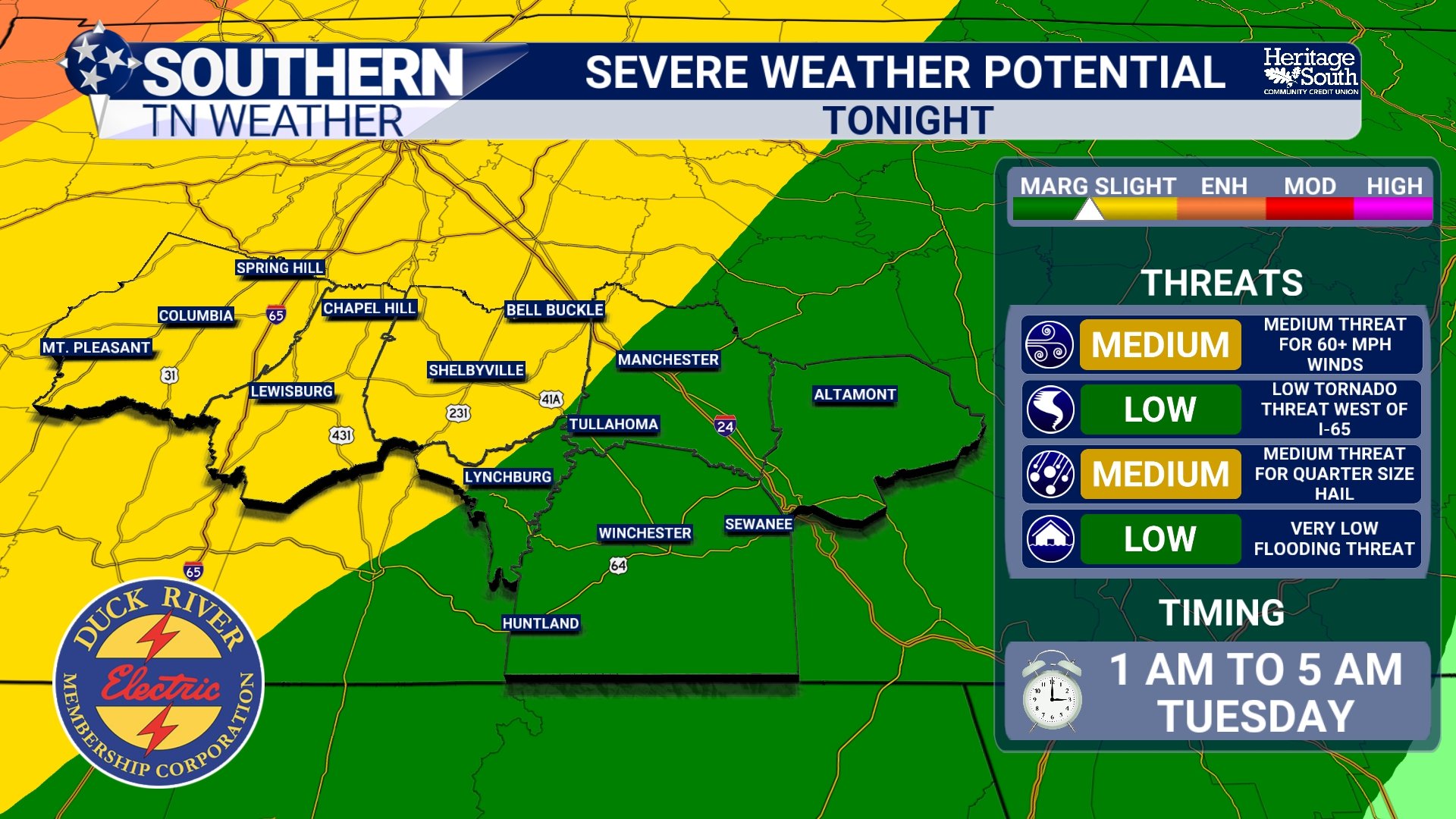
SEVERE POTENTIAL - TONIGHT
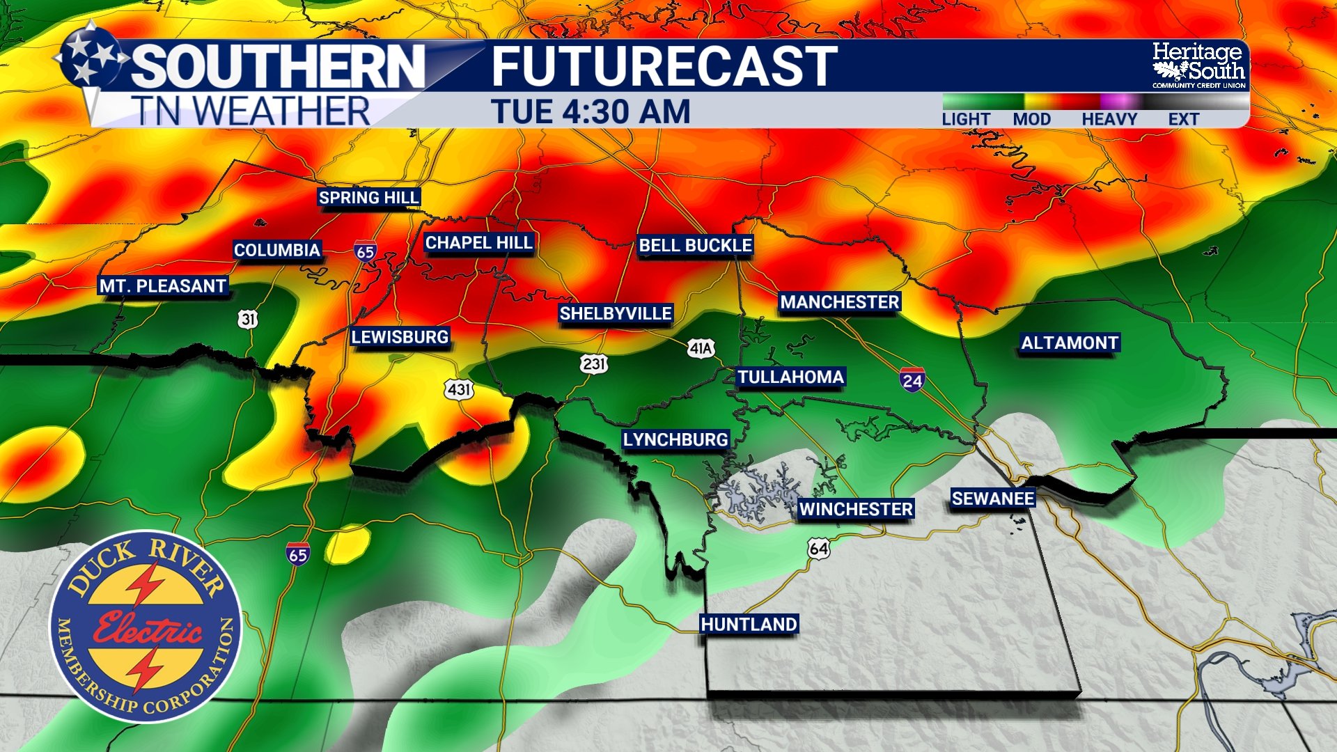
FUTURECAST - TONIGHT
TUESDAY: RESETTING THE ATMOSPHERE
Once this first round moves through, attention quickly shifts to what happens during the day Tuesday, and this is where things get complicated.
The atmosphere will likely be “worked over” Tuesday morning. That means the earlier storms will have stabilized the environment, reducing instability and temporarily limiting storm potential. In meteorology, we often talk about recovery. That refers to how quickly the atmosphere can regain heat, moisture, and instability after a round of storms. If we see enough sunshine and warming during the day Tuesday, the atmosphere can recover. If clouds linger and temperatures stay suppressed, recovery will be limited.
That recovery process is critical for what happens next.
TUESDAY NIGHT INTO WEDNESDAY: ROUND TWO
By Tuesday evening into early Wednesday morning, another system begins to take shape. This round is tied to a secondary disturbance riding along a leftover boundary from tonight’s storms. That boundary acts as a focus point for new storm development, especially if warmer, more unstable air can build back in south of it. Right now, timing for this second round is broad, generally 6 PM Tuesday through 6 AM Wednesday.
The environment Tuesday night looks somewhat more supportive of stronger storms compared to tonight, but it is still not a perfectly clean setup. There will be better moisture in place, improving instability, and increasing wind shear, all of which are ingredients for stronger storms.
However, there are still uncertainties. The exact position of that leftover boundary will determine where storms can develop and intensify. If it sets up farther south, that could shift the better threat away from parts of Southern Middle Tennessee. If it sets up closer to us, the risk increases locally. At this point, the main threats Tuesday night appear to be damaging winds and hail, with a low tornado risk. A level 2/5 SLIGHT risk is in place for the entire area.
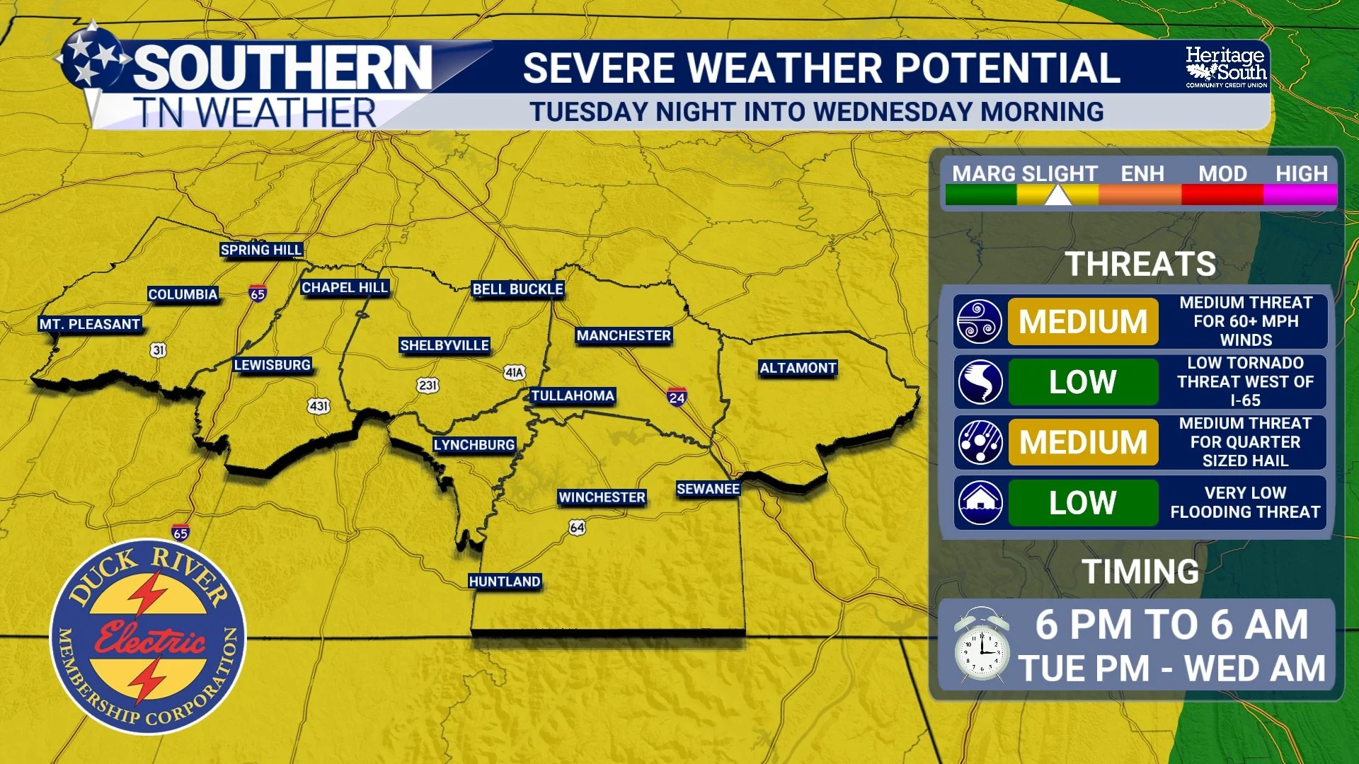
SEVERE POTENTIAL - TUESDAY NIGHT
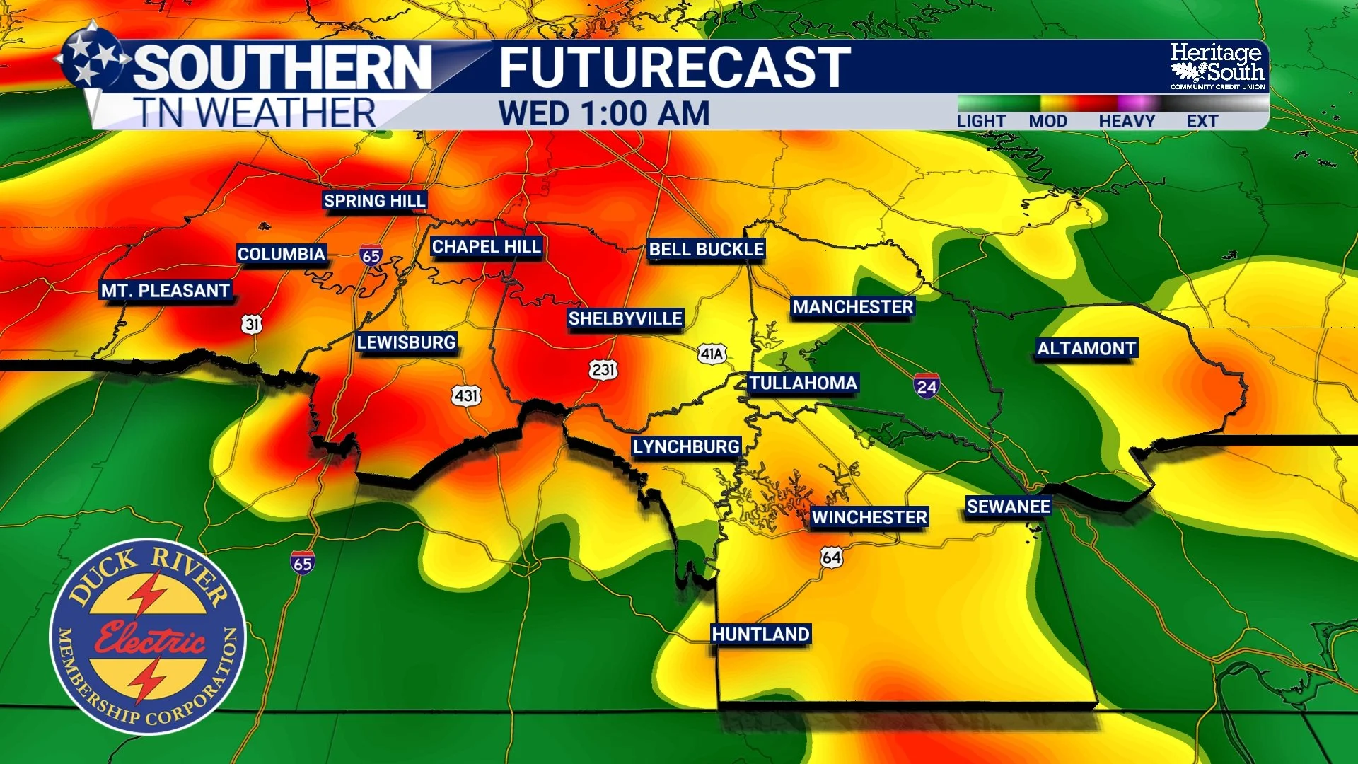
FUTURECAST - WEDNESDAY AM
RAINFALL AND THE DROUGHT
One of the more consistent aspects of this forecast is rainfall. Through both rounds of storms, most of Southern Middle Tennessee is expected to receive between 2 and 3 inches of rain by midweek. That is significant, especially given how dry it has been.
There will likely be periods of heavy downpours, and some areas could see brief ponding of water or standing water in low spots. However, this does not look like a widespread flooding event. The rain should come in waves rather than one prolonged, intense period. From a drought perspective, this is very welcome!
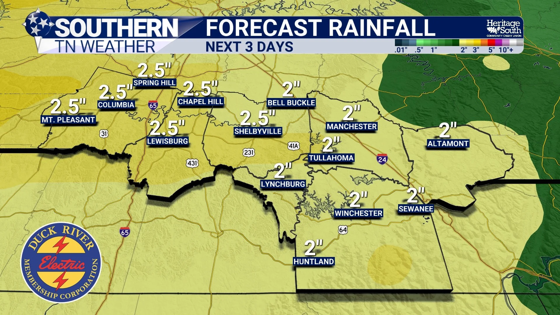
FORECAST RAINFALL - NEXT 3 DAYS
THE BIG PICTURE
This is a classic example of a multi-round storm setup where no single round is perfectly organized, but each carries its own set of impacts. Tonight’s system is messy and weakening, but still capable of producing isolated stronger storms, especially west of I-65. Tuesday’s weather depends heavily on how the atmosphere recovers. And Tuesday night brings a second opportunity for stronger storms, with slightly better ingredients in place but still plenty of uncertainty.
This is not a “set it and forget it” forecast. It’s one where you need to stay engaged over the next couple of days! We’ll have constant updates through the afternoon and evening.
The Bottom Line 🧾
Storms move in overnight tonight (1–5 AM) in a messy, broken line
A few stronger storms possible west of I-65 with gusty winds and hail
Main concern tonight is timing while people are asleep
Tuesday depends on how the atmosphere recovers
Second round of storms possible Tuesday night into Wednesday
2 to 3 inches of rain expected through midweek, helping the drought
📰 Reminder: The Southern Tennessee Weather Blog, presented by Heritage South Community Credit Union, is updated Monday through Friday with fresh, locally tailored forecasts you can trust.