
Monday: A Deeper Look into the Evolving Forecast

The Southern Tennessee Weather Blog is proudly presented by Heritage South Community Credit Union.
We Help When Others Won’t!
Visit https://www.heritagesouth.org/ today to see how HSCCU can help YOU!
We’re heading into a more active stretch of weather across Southern Middle Tennessee, and while there are some rain chances to get through this weekend, the bigger story is how the forecast has evolved for Monday. This is one of those situations where it’s worth slowing down and explaining not just what is happening, but WHY it’s happening.
Because this is meteorology in real time.
WEEKEND SETUP: SCATTERED AND UNEVEN
Let’s start with what’s right in front of us… Showers and storms begin to increase later today, but the environment across Southern Middle Tennessee is not particularly supportive of strong storm development. Instability remains limited, meaning there is not much energy available for storms to grow and intensify. Wind shear is also fairly weak, and the temperature profile of the atmosphere does not favor rapid vertical development.
What that leads to is a scattered setup. Some areas will see a round of showers and storms this evening into tonight, especially as a small disturbance moves overhead and provides additional lift. That lift simply helps air rise, which is necessary for clouds and rain to form. Even so, coverage will not be uniform. Some communities will pick up a decent shower, while others may barely see anything at all.
As we move into Saturday, there may still be some lingering showers during the morning hours, followed by a transition into more isolated, hit-or-miss activity during the afternoon. It will feel more humid, and a pop-up storm or two is possible, but overall organization remains weak and the severe threat stays very low. Due to the scattered nature of this activity, it’s hard to give a set timeframe.
Sunday should be mostly dry with highs in the 80s.
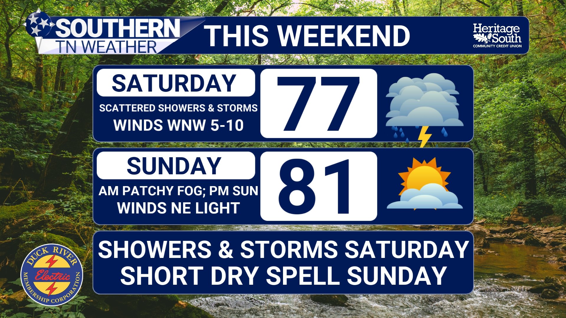
FORECAST - THIS WEEKEND
WHAT HAS CHANGED WITH MONDAY?
Earlier this week, there were stronger signals pointing toward a more widespread severe weather setup across Middle Tennessee on Monday. Since then, the forecast has adjusted, and the higher-end threat has shifted more toward the northwest across Missouri, Illinois, and Western Kentucky. The main reason comes down to the track of the upper-level trough.
A trough is essentially a dip in the jet stream, and it plays a critical role in storm development. It provides large-scale lift and helps organize thunderstorms. The latest data shows this trough tracking farther north than what we were seeing a couple of days ago. That shift matters, because when the core of the system tracks farther north, the strongest dynamics go with it. That includes the best lift, the strongest winds aloft, and the most favorable overlap of ingredients needed for severe storms. As a result, the highest-end threat is now aligning more with areas closer to the Ohio Valley and Mid-Mississippi Valley rather than being centered directly over all of Middle Tennessee. With that being said< i still think some sort of low-end severe risk will be at play for Monday night into Tuesday morning.
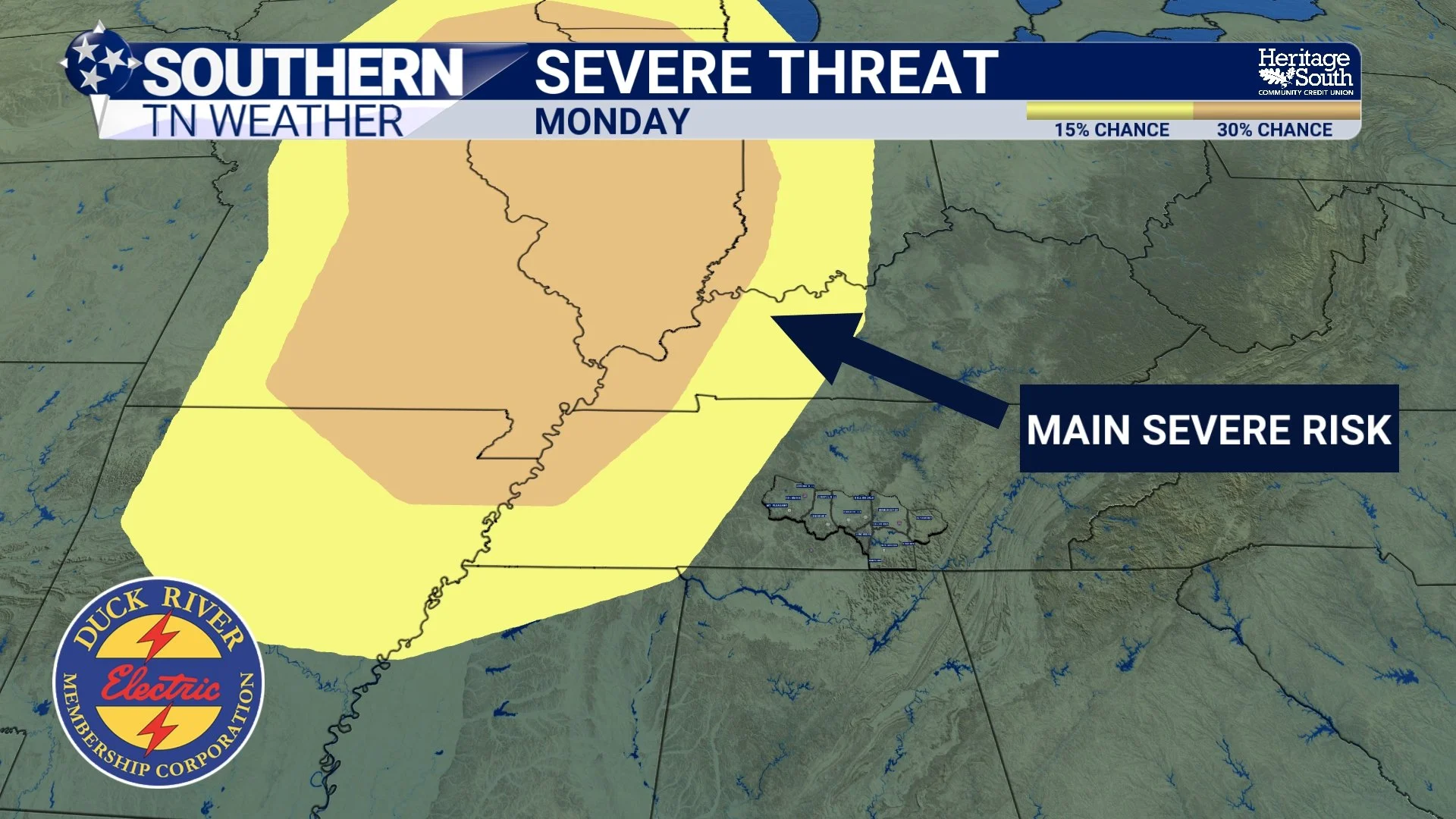
SEVERE THREAT - MONDAY
THE ROLE OF THE “CAP” AND TIMING
There are also some more subtle factors at play. One of those is the potential development of a cap. A cap is a layer of warm air above the surface that can suppress storm development. It acts like a lid, preventing air from rising freely. If that cap holds strong, it can limit how many storms form or delay development until later in the day.
Timing is also becoming more of a factor. Right now, the cold front associated with this system is expected to move into our area during the overnight hours. That is not ideal for severe weather locally, because instability tends to decrease after sunset as we lose daytime heating. So even though the system itself is strong, the local environment may not be at its peak when it arrives.
WHY WE ARE STILL WATCHING CLOSELY
Even with those changes, this is not a “nothing” setup. There will still be plenty of moisture in place, with dew points climbing into a more storm-friendly range. Wind shear is expected to increase significantly, which helps storms organize and sustain themselves. There will also still be enough instability to support thunderstorm development.
And that combination matters, because it does not take a perfect setup to produce impactful weather (a great example of this was last Thursday). If storms can develop ahead of the front, or if the cap weakens more than expected, we could still see strong to severe storms across parts of Southern Middle Tennessee. Damaging winds would be the primary concern, but hail and even a tornado cannot be completely ruled out. I do expect some sort of a broken line of showers / storms on Monday night into early Tuesday morning, which will bring the chance for some damaging wind gusts.
This is why we continue to talk about it. There is a difference between hyping a storm system and communicating a risk. Even if the overall threat has shifted, it is still important to stay aware and prepared.
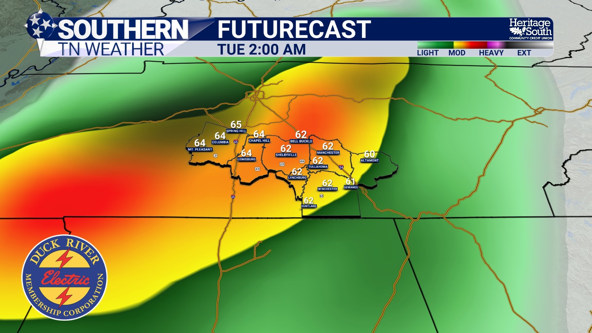
FUTURECAST - TUESDAY AM
A QUICK WORD ON FORECAST CHANGES
This is a great example of how forecasts evolve. Meteorology is not static. New data comes in constantly, and small changes in storm track, timing, or atmospheric structure can lead to noticeable differences in the final outcome. What we are seeing now is NOT a contradiction of earlier forecasts, but a refinement of them. We are getting closer, and therefore getting more precise.
THE BIG PICTURE
Friday and Saturday bring scattered, uneven rain chances with very low severe weather concerns. Monday remains the system with the higher ceiling, even though the greatest threat has shifted a bit to our northwest. The pattern overall is becoming more active, which is something we’ve needed given the drought. It also means we are entering a time where we need to stay a little more weather aware. And to my farmers… Don’t worry! Plenty of rain is still ON THE WAY over the next 7 days.
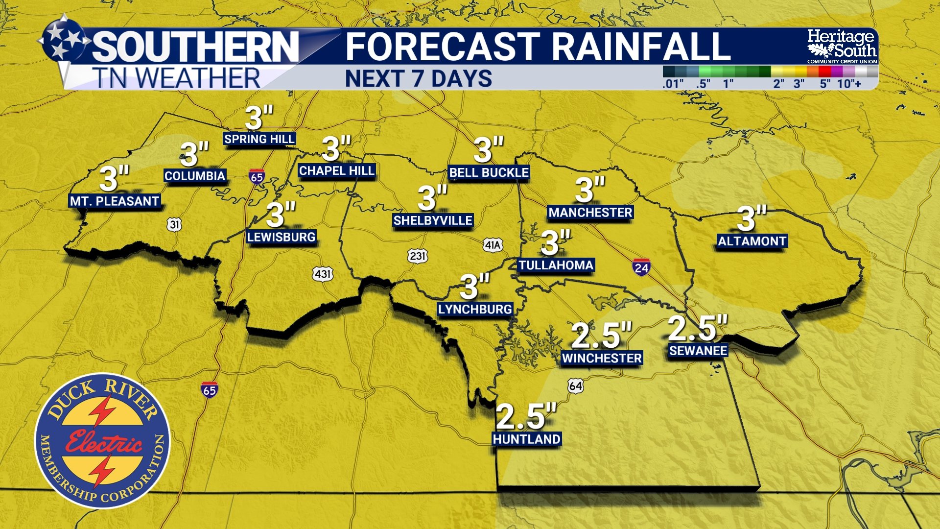
FORECAST RAINFALL - NEXT 7 DAYS
The Bottom Line 🧾
Scattered showers and storms today into tonight, severe threat very low
Better rain chances overnight into Saturday morning
Rain becomes more isolated Saturday afternoon
Monday’s higher-end severe threat has shifted northwest due to track changes
Still enough ingredients locally for strong storms, stay weather aware
📰 Reminder: The Southern Tennessee Weather Blog, presented by Heritage South Community Credit Union, is updated Monday through Friday with fresh, locally tailored forecasts you can trust.